Yeah it appears the leading edge of the colder airmass / front is progressing south much faster than most of the guidance, almost into the dfw area, global models are already a good 5-8 degrees l too warm, it will be colder than forecast! Bring it on!
I believe the secondary push of the really cold air with the reinforcing front will arrive Saturday night- early Sunday morning
Texas Fall 2023
Moderator: S2k Moderators
Forum rules

The posts in this forum are NOT official forecast and should not be used as such. They are just the opinion of the poster and may or may not be backed by sound meteorological data. They are NOT endorsed by any professional institution or STORM2K.
-
Stratton23
- Category 5

- Posts: 3434
- Joined: Fri Jul 21, 2023 10:59 pm
- Location: Katy, Tx
Re: Texas Fall 2023
1 likes

Re: Texas Fall 2023
Stratton23 wrote:Yeah it appears the leading edge of the colder airmass / front is progressing south much faster than most of the guidance, almost into the dfw area, global models are already a good 5-8 degrees l too warm, it will be colder than forecast! Bring it on!
I believe the secondary push of the really cold air with the reinforcing front will arrive Saturday night- early Sunday morning
I was thinking this earlier today however the front really hit a wall and the hourly forecast seem to lineup pretty well. I’m more interested in the rain possibility’s.
0 likes

Re: Texas Fall 2023
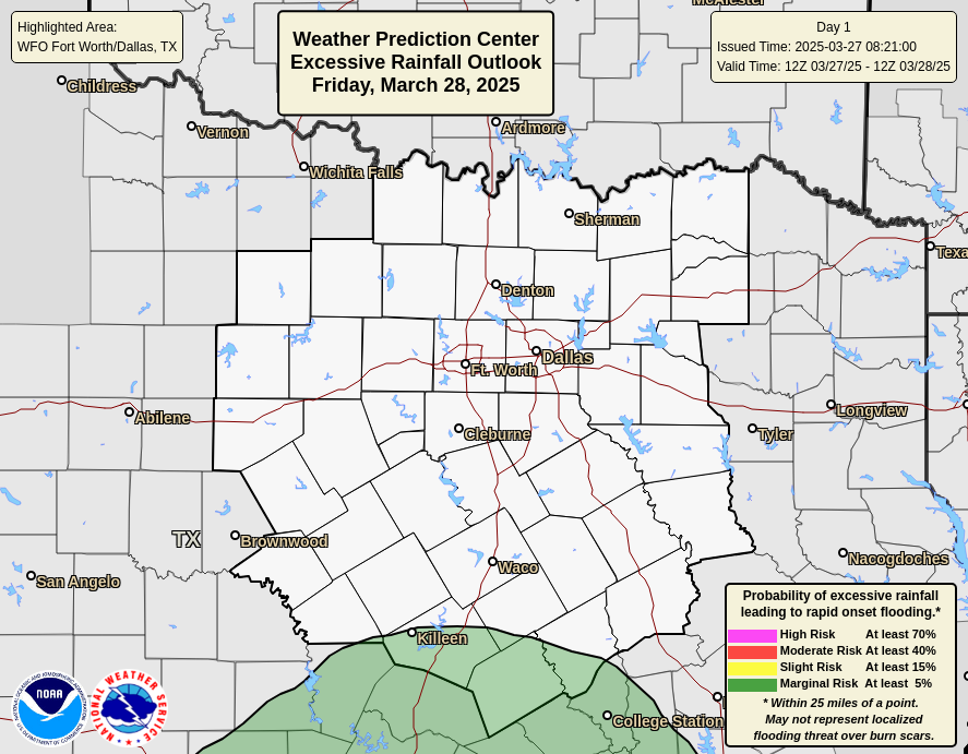
Flood Watch including Dallas and Tarrant counties until tomorrow morning.. 2-4 inches of rain with isolated areas getting 6+
2 likes
Re: Texas Fall 2023
JayDT wrote:Flood Watch including Dallas and Tarrant counties until tomorrow morning.. 2-4 inches of rain with isolated areas getting 6+
Hope some of that pushes west.
0 likes
-
bubba hotep

- S2K Supporter

- Posts: 5987
- Joined: Wed Dec 28, 2016 1:00 am
- Location: Collin County Texas
Re: Texas Fall 2023
JayDT wrote:Flood Watch including Dallas and Tarrant counties until tomorrow morning.. 2-4 inches of rain with isolated areas getting 6+

2 likes
Winter time post are almost exclusively focused on the DFW area.
-
tajmahal
- Tropical Storm

- Posts: 168
- Age: 68
- Joined: Tue Jan 10, 2012 10:09 am
- Location: Austin, TX area & eastern Africa
Re: Texas Fall 2023
Brent wrote:OKC has already dropped 20 degrees... Final hours of the 70s here. I don't even see a high of 70 anytime soon
Back to 70° for Tulsa by next Friday or Saturday.
0 likes
-
Iceresistance

- Category 5
- Posts: 9560
- Age: 22
- Joined: Sat Oct 10, 2020 9:45 am
- Location: Tecumseh, OK/Norman, OK
Re: Texas Fall 2023
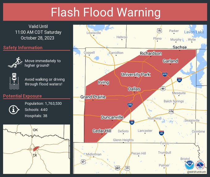
PDS Flash Flood Warning for Dallas
...FLASH FLOOD WARNING REMAINS IN EFFECT UNTIL 945 PM CDT THIS
EVENING FOR SOUTHEASTERN DALLAS, NORTHWESTERN KAUFMAN AND ROCKWALL
COUNTIES...
At 718 PM CDT, Doppler radar indicated thunderstorms producing heavy
rain across southwestern Dallas and Rockwall County. Between 3 and
3.5 inches of rain have fallen. Additional rainfall amounts of 1 to
2 inches are possible. Flash flooding is ongoing or expected to
begin shortly.
HAZARD...Life threatening flash flooding. Thunderstorms producing
flash flooding.
SOURCE...Radar.
IMPACT...Life threatening flash flooding of creeks and streams,
urban areas, highways, streets and underpasses.
Some locations that will experience flash flooding include...
Dallas, Garland, Mesquite, Rowlett, Desoto, Cedar Hill,
Duncanville, Rockwall, Lancaster, Balch Springs, Seagoville,
Forney, Glenn Heights, Hutchins, Royse City, Heath, Fate,
Sunnyvale, Wilmer and Ovilla.
PRECAUTIONARY/PREPAREDNESS ACTIONS...
Dangerous flash flooding is occurring or is imminent. Do not attempt
to travel unless you are fleeing flood waters. If you are in an area
subject to flooding, move to higher ground now.
Be especially cautious at night when it is harder to recognize the
dangers of flooding.
&&
LAT...LON 3255 9697 3278 9670 3298 9648 3298 9647
3298 9633 3273 9645 3255 9672 3255 9686
FLASH FLOOD...RADAR INDICATED
FLASH FLOOD DAMAGE THREAT...CONSIDERABLE
1 likes
Bill 2015 & Beta 2020
Winter 2020-2021
All observations are in Tecumseh, OK unless otherwise noted.
Winter posts are focused mainly for Oklahoma & Texas.
Take any of my forecasts with a grain of salt, refer to the NWS, SPC, and NHC for official information
Never say Never with weather! Because ANYTHING is possible!
Winter 2020-2021
All observations are in Tecumseh, OK unless otherwise noted.
Winter posts are focused mainly for Oklahoma & Texas.
Take any of my forecasts with a grain of salt, refer to the NWS, SPC, and NHC for official information
Never say Never with weather! Because ANYTHING is possible!

Re: Texas Fall 2023
Iceresistance wrote:PDS Flash Flood Warning for Dallas...FLASH FLOOD WARNING REMAINS IN EFFECT UNTIL 945 PM CDT THIS
EVENING FOR SOUTHEASTERN DALLAS, NORTHWESTERN KAUFMAN AND ROCKWALL
COUNTIES...
At 718 PM CDT, Doppler radar indicated thunderstorms producing heavy
rain across southwestern Dallas and Rockwall County. Between 3 and
3.5 inches of rain have fallen. Additional rainfall amounts of 1 to
2 inches are possible. Flash flooding is ongoing or expected to
begin shortly.
HAZARD...Life threatening flash flooding. Thunderstorms producing
flash flooding.
SOURCE...Radar.
IMPACT...Life threatening flash flooding of creeks and streams,
urban areas, highways, streets and underpasses.
Some locations that will experience flash flooding include...
Dallas, Garland, Mesquite, Rowlett, Desoto, Cedar Hill,
Duncanville, Rockwall, Lancaster, Balch Springs, Seagoville,
Forney, Glenn Heights, Hutchins, Royse City, Heath, Fate,
Sunnyvale, Wilmer and Ovilla.
PRECAUTIONARY/PREPAREDNESS ACTIONS...
Dangerous flash flooding is occurring or is imminent. Do not attempt
to travel unless you are fleeing flood waters. If you are in an area
subject to flooding, move to higher ground now.
Be especially cautious at night when it is harder to recognize the
dangers of flooding.
&&
LAT...LON 3255 9697 3278 9670 3298 9648 3298 9647
3298 9633 3273 9645 3255 9672 3255 9686
FLASH FLOOD...RADAR INDICATED
FLASH FLOOD DAMAGE THREAT...CONSIDERABLE
I’m so jealous. Models took almost all the rain away from me here in southeast TX over the past few days after looking so promising for several runs in a row.
0 likes
-
bubba hotep
- S2K Supporter
- Posts: 5987
- Joined: Wed Dec 28, 2016 1:00 am
- Location: Collin County Texas
-
Iceresistance
- Category 5
- Posts: 9560
- Age: 22
- Joined: Sat Oct 10, 2020 9:45 am
- Location: Tecumseh, OK/Norman, OK
Re: Texas Fall 2023
Brent wrote:OKC has already dropped 20 degrees... Final hours of the 70s here. I don't even see a high of 70 anytime soon
I do see 70s returning, but not the 80s.
0 likes
Bill 2015 & Beta 2020
Winter 2020-2021
All observations are in Tecumseh, OK unless otherwise noted.
Winter posts are focused mainly for Oklahoma & Texas.
Take any of my forecasts with a grain of salt, refer to the NWS, SPC, and NHC for official information
Never say Never with weather! Because ANYTHING is possible!
Winter 2020-2021
All observations are in Tecumseh, OK unless otherwise noted.
Winter posts are focused mainly for Oklahoma & Texas.
Take any of my forecasts with a grain of salt, refer to the NWS, SPC, and NHC for official information
Never say Never with weather! Because ANYTHING is possible!
-
Brent
- S2K Supporter
- Posts: 38683
- Age: 37
- Joined: Sun May 16, 2004 10:30 pm
- Location: Tulsa Oklahoma
- Contact:
Re: Texas Fall 2023
tajmahal wrote:Brent wrote:OKC has already dropped 20 degrees... Final hours of the 70s here. I don't even see a high of 70 anytime soon
Back to 70° for Tulsa by next Friday or Saturday.
I guess we will see and it's possible but so far the warmest high then is 68.
In more current news there's definitely a chill in the air. It finally feels like Halloween
 still wonder if we might see some rogue snowflakes or sleet pellets nearby
0 likes
#neversummer
-
bubba hotep
- S2K Supporter
- Posts: 5987
- Joined: Wed Dec 28, 2016 1:00 am
- Location: Collin County Texas


Re: Texas Fall 2023
Love all the rain we have gotten here but need a chance to dry out and send it south some. Ready for the cold.
3 likes
The above post and any post by Ntxw is NOT an official forecast and should not be used as such. It is just the opinion of the poster and may or may not be backed by sound meteorological data. It is NOT endorsed by any professional institution including Storm2k. For official information, please refer to NWS products.
Help support Storm2K!
-
bubba hotep
- S2K Supporter
- Posts: 5987
- Joined: Wed Dec 28, 2016 1:00 am
- Location: Collin County Texas
Re: Texas Fall 2023
Some areas down near Glen Rose are pushing 1' of rain since this rainy period started 
1 likes
Winter time post are almost exclusively focused on the DFW area.
-
bubba hotep
- S2K Supporter
- Posts: 5987
- Joined: Wed Dec 28, 2016 1:00 am
- Location: Collin County Texas
Re: Texas Fall 2023
cstrunk wrote:Parts of the Dallas area have received 6-10" in the last 12 hours.
SE Dallas County got hammered
0 likes
Winter time post are almost exclusively focused on the DFW area.
-
wxman57

- Moderator-Pro Met

- Posts: 23168
- Age: 68
- Joined: Sat Jun 21, 2003 8:06 pm
- Location: Houston, TX (southwest)
Re: Texas Fall 2023
6Z GFS has us a little less cold behind the front. My wall reinforcement is working. A few more layers to add...

0 likes
-
bubba hotep
- S2K Supporter
- Posts: 5987
- Joined: Wed Dec 28, 2016 1:00 am
- Location: Collin County Texas
Re: Texas Fall 2023
Lake Travis up 4' now.
EWX has pushed up FROPApassage here (Austin) from Sunday evening to Sunday noon-ish.
Edit: I suppose "FROPA passage" is redundant. /pedantry
EWX has pushed up FROPA
Edit: I suppose "FROPA passage" is redundant. /pedantry
Last edited by utpmg on Sat Oct 28, 2023 10:12 am, edited 1 time in total.
1 likes
-
rwfromkansas
- Category 5
- Posts: 2999
- Joined: Sat Aug 27, 2005 12:47 am
- Location: North Fort Worth
Re: Texas Fall 2023
Up to another 1.5 inches after being dry most of the night.
Fine with me since was in the bullseye last time so 1-2 inches additional is reasonable. Don’t need another 8!
Fine with me since was in the bullseye last time so 1-2 inches additional is reasonable. Don’t need another 8!
1 likes
Return to “USA & Caribbean Weather”
Who is online
Users browsing this forum: No registered users and 77 guests