Possible Development in the Central / SW Caribbean (Is Invest 97L)
Moderator: S2k Moderators
Forum rules

The posts in this forum are NOT official forecasts and should not be used as such. They are just the opinion of the poster and may or may not be backed by sound meteorological data. They are NOT endorsed by any professional institution or STORM2K. For official information, please refer to products from the National Hurricane Center and National Weather Service.
-
DunedinDave
- Category 1

- Posts: 269
- Joined: Fri Aug 25, 2023 10:31 am
Re: Possible Development in the Central / SW Caribbean
Two cold fronts expected to sweep through Florida—Wednesday and then next Thursday or Friday. So the only way I can see Fla hit by this is if something forms from the front this weekend and pulls north within a few days. Possible but I think Fla may be protected by the time of year. The front this week is expected to bring temps in low 50s near Tampa Bay, so it will def cool the waters in East Gulf.
1 likes

Re: Possible Development in the Central / SW Caribbean
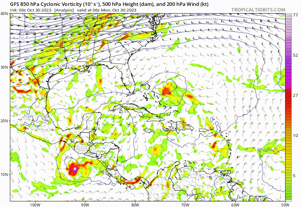
Here's the latest GFS run 06z, look like Nicaragua will be getting another storm.
0 likes
-
REDHurricane

- Category 1
- Posts: 438
- Age: 28
- Joined: Sun Jul 03, 2022 2:36 pm
- Location: Northeast Pacific Ocean
Re: Possible Development in the Central / SW Caribbean
ChrisH-UK wrote:Here's the latest GFS run 06z, look like Nicaragua will be getting another storm.
[url]https://imagizer.imageshack.com/img922/8464/0mN1cl.gif [/url]
GFS ensemble is still split between the two solutions (west into Nicaragua/Honduras vs. recurve through Cuba/Bahamas/maybe south Florida) somewhat evenly, though all of the ensembles seem to be trending towards the western track over the past few runs. However, I think we're just going to have to wait until a LLC actually forms before the models can forecast this storm's path with any degree of certainty.
3 likes
-
cycloneye

- Admin

- Posts: 149696
- Age: 69
- Joined: Thu Oct 10, 2002 10:54 am
- Location: San Juan, Puerto Rico
Re: Possible Development in the Central / SW Caribbean
REDHurricane wrote:ChrisH-UK wrote:Here's the latest GFS run 06z, look like Nicaragua will be getting another storm.
[url]https://imagizer.imageshack.com/img922/8464/0mN1cl.gif [/url]
GFS ensemble is still split between the two solutions (west into Nicaragua/Honduras vs. recurve through Cuba/Bahamas/maybe south Florida) somewhat evenly, though all of the ensembles seem to be trending towards the western track over the past few runs. However, I think we're just going to have to wait until a LLC actually forms before the models can forecast this storm's path with any degree of certainty.
https://media1.giphy.com/media/v1.Y2lkPTc5MGI3NjExM20wd25hejV2NDhxNDExd2NncXc1OG4ybTVxeTIxOWN5N3k2NHdwYiZlcD12MV9pbnRlcm5hbF9naWZfYnlfaWQmY3Q9Zw/ODTz6OxGqLaEQADVpZ/giphy.gif
When the invest is tagged, we will get the full package of models and a more clear picture will unfold.
1 likes
Visit the Caribbean-Central America Weather Thread where you can find at first post web cams,radars
and observations from Caribbean basin members Click Here
and observations from Caribbean basin members Click Here
-
Iceresistance

- Category 5

- Posts: 9605
- Age: 22
- Joined: Sat Oct 10, 2020 9:45 am
- Location: Tecumseh, OK/Norman, OK
Re: Possible Development in the Central / SW Caribbean
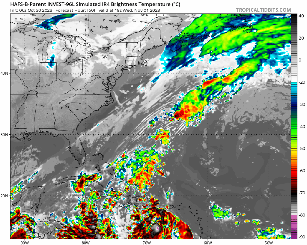
This looks nasty, panned back to the SW to see what is going on in the Caribbean
https://s6.gifyu.com/images/S873d.gif
https://s6.gifyu.com/images/S873d.gif
1 likes
Bill 2015 & Beta 2020
Winter 2020-2021
All observations are in Tecumseh, OK unless otherwise noted.
Winter posts are focused mainly for Oklahoma & Texas.
Take any of my forecasts with a grain of salt, refer to the NWS, SPC, and NHC for official information
Never say Never with weather! Because ANYTHING is possible!
Winter 2020-2021
All observations are in Tecumseh, OK unless otherwise noted.
Winter posts are focused mainly for Oklahoma & Texas.
Take any of my forecasts with a grain of salt, refer to the NWS, SPC, and NHC for official information
Never say Never with weather! Because ANYTHING is possible!
-
ThunderForce

- Tropical Storm

- Posts: 208
- Age: 26
- Joined: Tue Sep 27, 2022 6:20 pm
- Location: Calhoun County, Florida
Re: Possible Development in the Central / SW Caribbean
Iceresistance wrote:This looks nasty, panned back to the SW to see what is going on in the Caribbean
https://s6.gifyu.com/images/S873d.gif
https://s6.gifyu.com/images/S873d.gif
Yikes, that looks more like a monstrous Pacific typhoon than it does your typical Atlantic hurricane.
0 likes
Please refer to the NWS, NHC, SPC or a professional meteorologist for information and decision making during storms.
-
SFLcane

- S2K Supporter

- Posts: 10281
- Age: 48
- Joined: Sat Jun 05, 2010 1:44 pm
- Location: Lake Worth Florida
Re: Possible Development in the Central / SW Caribbean
Iceresistance wrote:This looks nasty, panned back to the SW to see what is going on in the Caribbean
https://s6.gifyu.com/images/S873d.gif
https://s6.gifyu.com/images/S873d.gif
Never use the parent domain of a nested model. The convective parameterization always spins systems up to quickly.
1 likes

Re: Possible Development in the Central / SW Caribbean
Kind of ironic that the CONUS has been spared from all the Cape Verde storms by persistent troughing, but now that there's a Caribbean storm it may be saved by ridging.
7 likes
Igor 2010, Sandy 2012, Fay 2014, Gonzalo 2014, Joaquin 2015, Nicole 2016, Humberto 2019, Imelda 2025
I am only a tropical weather enthusiast. My predictions are not official and may or may not be backed by sound meteorological data. For official information, please refer to the NHC and NWS products.
I am only a tropical weather enthusiast. My predictions are not official and may or may not be backed by sound meteorological data. For official information, please refer to the NHC and NWS products.
-
cycloneye
- Admin
- Posts: 149696
- Age: 69
- Joined: Thu Oct 10, 2002 10:54 am
- Location: San Juan, Puerto Rico
Re: Possible Development in the Central / SW Caribbean
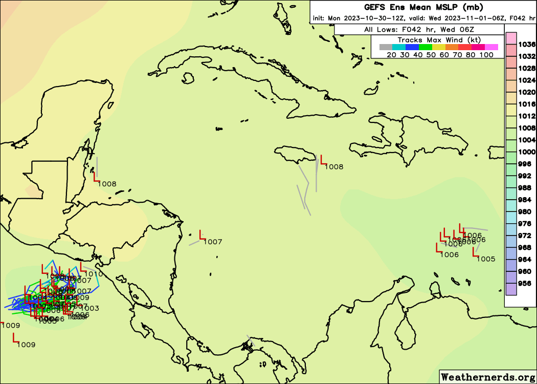
12 GFS =Much weaker amd more buried in CA.

0 likes
Visit the Caribbean-Central America Weather Thread where you can find at first post web cams,radars
and observations from Caribbean basin members Click Here
and observations from Caribbean basin members Click Here

Re: Possible Development in the Central / SW Caribbean
12z GFS weaker, but would be a rain disaster for parts of CA with 24+ inches along the coast.

1 likes
-
ElectricStorm

- Category 5
- Posts: 5153
- Age: 25
- Joined: Tue Aug 13, 2019 11:23 pm
- Location: Norman, OK
Re: Possible Development in the Central / SW Caribbean
I think the 12z GFS is more realistic, similar to the other models. I think a TS tracking into CA is most likely, although I could see a Julia or Lisa situation where it really starts to get going right before landfall, but runs out of time to get too strong. I'd be hesitant to expect anything more than a minimal Cat 1 for now, unless it develops way earlier than expected
0 likes
B.S Meteorology, University of Oklahoma '25
Please refer to the NHC, NWS, or SPC for official information.
Please refer to the NHC, NWS, or SPC for official information.
-
Weathertracker96
- Tropical Storm
- Posts: 150
- Joined: Mon Oct 16, 2023 3:41 pm
Re: Possible Development in the Central / SW Caribbean
Just checked the 12z GFS, is it trying to strength the system again? It seems be staying in the NW Caribbean and the frame I just saw had it 999mb down from 1004mb
1 likes
-
cycloneye
- Admin
- Posts: 149696
- Age: 69
- Joined: Thu Oct 10, 2002 10:54 am
- Location: San Juan, Puerto Rico
Re: Possible Development in the Central / SW Caribbean
The long range 12z GFS is the most crazy one I'd ever seen and I have seen a lot of model runs since I began at S2K. 
2 likes
Visit the Caribbean-Central America Weather Thread where you can find at first post web cams,radars
and observations from Caribbean basin members Click Here
and observations from Caribbean basin members Click Here
-
ElectricStorm
- Category 5
- Posts: 5153
- Age: 25
- Joined: Tue Aug 13, 2019 11:23 pm
- Location: Norman, OK
Re: Possible Development in the Central / SW Caribbean
The GFS really is something else 
I think it's time for another upgrade lol
I think it's time for another upgrade lol
1 likes
B.S Meteorology, University of Oklahoma '25
Please refer to the NHC, NWS, or SPC for official information.
Please refer to the NHC, NWS, or SPC for official information.
-
Hurricane2022

- Category 5
- Posts: 2090
- Joined: Tue Aug 23, 2022 11:38 pm
- Location: Araçatuba, Brazil
Re: Possible Development in the Central / SW Caribbean
I'm sure I've seen worse rounds than this 12Z but it shows the GFS in its purest possible state.
Last edited by Hurricane2022 on Mon Oct 30, 2023 12:18 pm, edited 1 time in total.
1 likes
Sorry for the bad English sometimes...!
For reliable and detailed information for any meteorological phenomenon, please consult the National Hurricane Center, Joint Typhoon Warning Center , or your local Meteo Center.
--------
ECCE OMNIA NOVA FACIAM (Ap 21,5).
For reliable and detailed information for any meteorological phenomenon, please consult the National Hurricane Center, Joint Typhoon Warning Center , or your local Meteo Center.
--------
ECCE OMNIA NOVA FACIAM (Ap 21,5).
-
Iceresistance
- Category 5
- Posts: 9605
- Age: 22
- Joined: Sat Oct 10, 2020 9:45 am
- Location: Tecumseh, OK/Norman, OK
Re: Possible Development in the Central / SW Caribbean

2 likes
Bill 2015 & Beta 2020
Winter 2020-2021
All observations are in Tecumseh, OK unless otherwise noted.
Winter posts are focused mainly for Oklahoma & Texas.
Take any of my forecasts with a grain of salt, refer to the NWS, SPC, and NHC for official information
Never say Never with weather! Because ANYTHING is possible!
Winter 2020-2021
All observations are in Tecumseh, OK unless otherwise noted.
Winter posts are focused mainly for Oklahoma & Texas.
Take any of my forecasts with a grain of salt, refer to the NWS, SPC, and NHC for official information
Never say Never with weather! Because ANYTHING is possible!
-
cheezyWXguy

- Category 5
- Posts: 6282
- Joined: Mon Feb 13, 2006 12:29 am
- Location: Dallas, TX
Re: Possible Development in the Central / SW Caribbean
Lol not gonna comment much on the absurdity of the storm track itself, but what I glean from the run is the favorability of conditions in the western Caribbean and weak steering currents if any diving fronts aren’t strong enough to lift it out. Basically just confirms the notion that storm strength will be determined by how much land interaction the ridging produces.
With the ensemble signal looking more like a probability cloud than a cone of uncertainty, deterministic model runs will likely continue to be useless in determining track until something forms imo.
With the ensemble signal looking more like a probability cloud than a cone of uncertainty, deterministic model runs will likely continue to be useless in determining track until something forms imo.
1 likes
-
ScottNAtlanta

- Category 5
- Posts: 2535
- Joined: Sat May 25, 2013 3:11 pm
- Location: Atlanta, GA
Re: Possible Development in the Central / SW Caribbean
The front going through Atlanta toady (which will bring our first freeze tomorrow) is the strongest front so far and the strongest one modeled for the next week, so the fronts not digging down far enough is a very real possibility. Hopefully I dont hurt my back pulling my plants back in the house.
0 likes
The posts in this forum are NOT official forecast and should not be used as such. They are just the opinion of the poster and may or may not be backed by sound meteorological data. They are NOT endorsed by any professional institution or storm2k.org. For official information, please refer to the NHC and NWS products.
-
cycloneye
- Admin
- Posts: 149696
- Age: 69
- Joined: Thu Oct 10, 2002 10:54 am
- Location: San Juan, Puerto Rico
Re: Possible Development in the Central / SW Caribbean
2 PM TWO:
A trough of low pressure over the eastern Caribbean Sea is producing
disorganized showers and thunderstorms. This system is expected to
move westward during the next several days, and environmental
conditions appear conducive for gradual development. A tropical
depression could form late this week when the system reaches the
central or southwestern Caribbean Sea.
* Formation chance through 48 hours...low...20 percent.
* Formation chance through 7 days...medium...60 percent.
0 likes
Visit the Caribbean-Central America Weather Thread where you can find at first post web cams,radars
and observations from Caribbean basin members Click Here
and observations from Caribbean basin members Click Here
Who is online
Users browsing this forum: No registered users and 204 guests