tolakram wrote:I've seen people argue, but is there any professional grade material that indicates this was an unusual start to el nino?
BOM's ENSO outlooks prior to their declaration of El Niño this year
Moderator: S2k Moderators


tolakram wrote:I've seen people argue, but is there any professional grade material that indicates this was an unusual start to el nino?


dexterlabio wrote:Kingarabian wrote:Successive WWB's to close out the year.
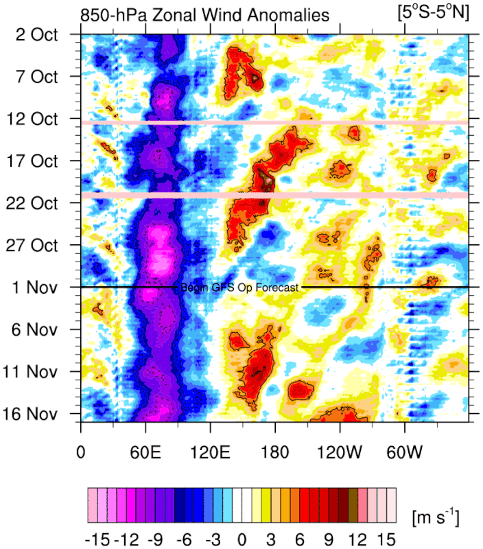
https://i.postimg.cc/x8QcY0rd/u-anom-30-5-S-5-N.gif
Wouldn't this help the chances of a second-year Niño?


weeniepatrol wrote:dexterlabio wrote:Kingarabian wrote:Successive WWB's to close out the year.
https://i.postimg.cc/x8QcY0rd/u-anom-30-5-S-5-N.gif
Wouldn't this help the chances of a second-year Niño?
I don't think so, multiple points to be made here:
1. Historically el Ninos of this amplitude always transition the following year
2. PDO remains negative
3. WPAC warm pool is becoming increasingly depleted. Not going to be much fuel left for any sort of El Nino next year. Need some strong trades to pile warm waters back west
https://i.imgur.com/jD6mxxA.gif
dexterlabio wrote:Dean_175 wrote:dexterlabio wrote:
Wouldn't this help the chances of a second-year Niño?
No, second year El Nino events are usually events that begin without much atmospheric coupling (like 2014) or begin late in the year like 1986 and therefore have abnormal coupling to the seasonal cycle. It will help push some more warm water east to boost the peak of this year but not likely to produce warm ENSO next year. There is decent model support for the creation of a subsurface cool pool that will spread eastward in 2024, possibly leading to La Nina, but almost certainly ending El Nino. Going by climatology, this event has been strong enough for long enough to produce negative feedback and the end of the event next year. Despite being a positive feedback coupled interaction, ENSO events are self limiting/are part of an oscillation and El Nino does not typically extend to two northern hemisphere winters. For example, while there was WWB activity in early 2016 and early 1998, both years evolved into La Nina due to changes in the distribution of Pacific equatorial ocean heat content. Since 1950, only one strong (>1.5C ONI) El Nino was followed by another El Nino (1957 was strong and 1958 was weak).
In short, a WWB now is just an indication the atmosphere is responding typically to an El Nino ocean.
But the atmosphere-ocean coupling seems to be happening only now. Many people would argue that the atmosphere for the past few months was not really El Niño-like with the lack of true WWBs in the Pacific, this in contrast to the warm Niño regions.
As you said, second year Niños seem to happen when the atmospheric response occured late in the game. This is definitely just a speculation though.
Teban54 wrote:One thing I'm wondering: If this El Nino is so atypical (warm Atlantic, slow atmospheric coupling, lack of WWBs until fall, etc) and in uncharted territory, how can we be sure that the typical climo of "strong El Ninos often turn into La Ninas" still applies well here? In other words, if the reduced temperature difference due to a warm Atlantic made this year more like a weak El Nino rather than a strong one, perhaps it may also not follow the traditional transition patterns of a strong Nino?
This is just one factor out of many that others have explained really well, but it's just something to think about.

weeniepatrol wrote:Teban54 wrote:One thing I'm wondering: If this El Nino is so atypical (warm Atlantic, slow atmospheric coupling, lack of WWBs until fall, etc) and in uncharted territory, how can we be sure that the typical climo of "strong El Ninos often turn into La Ninas" still applies well here? In other words, if the reduced temperature difference due to a warm Atlantic made this year more like a weak El Nino rather than a strong one, perhaps it may also not follow the traditional transition patterns of a strong Nino?
This is just one factor out of many that others have explained really well, but it's just something to think about.
I get what you're saying, but I don't buy it yet. Again the WPAC is developing a cool pool, but Antimeridian westerlies are forecast to continue, which will reinforce this cool pool as yet more Pacific heat is redistributed towards the east. Nino 3.4 will peak in anomalies in a month or two due to these westerlies, but underneath the surface (literally and metaphorically) the beginnings of a transition to cold ENSO are initiating. For what little it's worth climate models love the idea of cold neutral by Summer. Of course, We still have an entire SPB coming up, and intraseasonal forcing could go either way. So, I'm not thinking it's impossible, but just quite likely that this el Nino dissipates next year. As long as the cool pool remains (and perhaps expands/strengthens following the next downwelling Kelvin wave or two that is imminent from the Dateline westerly wind burst), any inactive MJO forcing next Spring should result in upwelling Kelvin wave activity and SSTs from enhanced trades.


USTropics wrote:Teban54 wrote:One thing I'm wondering: If this El Nino is so atypical (warm Atlantic, slow atmospheric coupling, lack of WWBs until fall, etc) and in uncharted territory, how can we be sure that the typical climo of "strong El Ninos often turn into La Ninas" still applies well here? In other words, if the reduced temperature difference due to a warm Atlantic made this year more like a weak El Nino rather than a strong one, perhaps it may also not follow the traditional transition patterns of a strong Nino?
This is just one factor out of many that others have explained really well, but it's just something to think about.
In the grand scheme of things, ENSO is the driving force for atmosphere-ocean coupling. The Atlantic doesn't really have much say in it (i.e., Atlantic can negate some of the negative effects imposed on it by ENSO, but it's not a driving force for ENSO state). It's difficult to get multi year El ninos (after all, at its core mother nature is always trying to correct back to equilibrium). So I don't think the Atlantic SSTA would have an impact on this, it would have to be external forcings acting on ENSO state. In meteorology you learn to never say never (and we did just have a 3 year Nina essentially), but it would be highly anomalous and require extensive external forcings.


SFLcane wrote:Cool neutral is one of the more dangerous setups for the CONUS
Users browsing this forum: gib, Google Adsense [Bot] and 166 guests

