
These late season systems are notoriously difficult to forecast, especially when interacting with a frontal low so it is surprising to see the models in pretty good agreement this early on.
What I have noticed is the models will be over bullish on one of the lows, and bearish on the other. If the frontal low is stronger, what maybe future Vince will be weaker and if the front is weaker Vince is stronger.
While unlikely, I suppose it is not impossible to see one giant nor'easter type of system instead of two distinct lows...gotta through the worst case scenario out there.
Possible development in the SW Caribbean (Is Invest 98L)
Moderator: S2k Moderators
Forum rules

The posts in this forum are NOT official forecasts and should not be used as such. They are just the opinion of the poster and may or may not be backed by sound meteorological data. They are NOT endorsed by any professional institution or STORM2K. For official information, please refer to products from the National Hurricane Center and National Weather Service.
-
USTropics
- Professional-Met

- Posts: 2739
- Joined: Sun Aug 12, 2007 3:45 am
- Location: Florida State University
Re: Possible development in the SW Caribbean
underthwx wrote:
So, is the GFS the favored model with this system?
A blend of model and ensemble output is the favored forecast here. ECMWF/GFS ensembles are in relatively good agreement on two potential tracks now: (1) a system that has weak steering currents and either dissipates or drifts towards Central America and (2) a quick track towards the NE across potentially Jamaica/Cuba/Hispaniola. Given our global numerical model outputs (GFS/ECMWF/CMC), solutions for (2) seem more probable at this time.
12z ECMWF ensembles:

12z GFS ensembles:

2 likes
Re: Possible development in the SW Caribbean
For the first time I can recall, the UKMET (12Z) has TCG for this in their textual product. Actual TCG isn’t until the C Bahamas after which it moves NE toward Bermuda as a 994 mb TS:
NEW TROPICAL CYCLONE FORECAST TO DEVELOP AFTER 144 HOURS
FORECAST POSITION AT T+144 : 22.3N 73.6W
LEAD CENTRAL MAXIMUM WIND
VERIFYING TIME TIME POSITION PRESSURE (MB) SPEED (KNOTS)
-------------- ---- -------- ------------- -------------
1200UTC 18.11.2023 144 22.3N 73.6W 1001 32
0000UTC 19.11.2023 156 25.2N 69.9W 1000 40
1200UTC 19.11.2023 168 30.0N 64.9W 994 42
2 likes
Personal Forecast Disclaimer:
The posts in this forum are NOT official forecasts and should not be used as such. They are just the opinion of the poster and may or may not be backed by sound meteorological data. They are NOT endorsed by any professional institution or storm2k.org. For official information, please refer to the NHC and NWS products.
The posts in this forum are NOT official forecasts and should not be used as such. They are just the opinion of the poster and may or may not be backed by sound meteorological data. They are NOT endorsed by any professional institution or storm2k.org. For official information, please refer to the NHC and NWS products.
-
cycloneye

- Admin

- Posts: 149696
- Age: 69
- Joined: Thu Oct 10, 2002 10:54 am
- Location: San Juan, Puerto Rico
Re: Possible development in the SW Caribbean
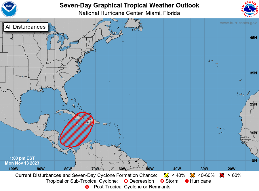
Tropical Weather Outlook
NWS National Hurricane Center Miami FL
700 PM EST Sun Nov 12 2023
For the North Atlantic...Caribbean Sea and the Gulf of Mexico:
1. Southwestern Caribbean Sea:
A broad area of low pressure is likely to form over the
southwestern Caribbean Sea in a few days. Gradual development is
possible thereafter, and a tropical depression could form late this
week while the system drifts northeastward across the western and
central portions of the Caribbean Sea.
* Formation chance through 48 hours...low...near 0 percent.
* Formation chance through 7 days...medium...60 percent.
Forecaster Blake
1 likes
Visit the Caribbean-Central America Weather Thread where you can find at first post web cams,radars
and observations from Caribbean basin members Click Here
and observations from Caribbean basin members Click Here
Re: Possible development in the SW Caribbean
0Z UKMET:
NEW TROPICAL CYCLONE FORECAST TO DEVELOP AFTER 108 HOURS
FORECAST POSITION AT T+108 : 29.3N 78.0W
LEAD CENTRAL MAXIMUM WIND
VERIFYING TIME TIME POSITION PRESSURE (MB) SPEED (KNOTS)
-------------- ---- -------- ------------- -------------
1200UTC 17.11.2023 108 29.3N 78.0W 1005 38
0000UTC 18.11.2023 120 30.1N 78.3W 1003 32
1200UTC 18.11.2023 132 31.1N 76.6W 1000 23
0000UTC 19.11.2023 144 31.7N 72.9W 998 29
1200UTC 19.11.2023 156 CEASED TRACKING
1 likes
Personal Forecast Disclaimer:
The posts in this forum are NOT official forecasts and should not be used as such. They are just the opinion of the poster and may or may not be backed by sound meteorological data. They are NOT endorsed by any professional institution or storm2k.org. For official information, please refer to the NHC and NWS products.
The posts in this forum are NOT official forecasts and should not be used as such. They are just the opinion of the poster and may or may not be backed by sound meteorological data. They are NOT endorsed by any professional institution or storm2k.org. For official information, please refer to the NHC and NWS products.

Re: Possible development in the SW Caribbean
Tropical Weather Outlook
NWS National Hurricane Center Miami FL
700 AM EST Mon Nov 13 2023
For the North Atlantic...Caribbean Sea and the Gulf of Mexico:
Southwestern Caribbean Sea:
A broad area of low pressure is expected to form over the
southwestern Caribbean Sea in a few days. Gradual development of
this system is possible thereafter, and a tropical depression could
form late this week while the system begins moving northeastward
across the western and central portions of the Caribbean Sea.
* Formation chance through 48 hours...low...near 0 percent.
* Formation chance through 7 days...medium...60 percent.
$$
Forecaster Papin
0 likes
Re: Possible development in the SW Caribbean
I think we may see a 24 hr lemon soon.
I am amazed at the model agreement on track, towards Jamaica, east Cuba and Haiti and accelerating to the northeast.
I am amazed at the model agreement on track, towards Jamaica, east Cuba and Haiti and accelerating to the northeast.
1 likes
Re: Possible development in the SW Caribbean
Tropical Weather Outlook
NWS National Hurricane Center Miami FL
100 PM EST Mon Nov 13 2023
For the North Atlantic...Caribbean Sea and the Gulf of Mexico:
Southwestern Caribbean Sea:
A broad area of low pressure is expected to form over the
southwestern Caribbean Sea in the next few days. Environmental
conditions appear favorable for additional development of this
system thereafter, and a tropical depression is likely to form late
this week while the system begins moving northeastward across the
western and central portions of the Caribbean Sea. Interests in
Jamaica, Haiti, and the Dominican Republic should monitor the
progress of this system. Regardless of development, this system has
the potential to produce heavy rains over portions of the Caribbean
coast of Central America and the Greater Antilles towards to latter
portions of this week.
* Formation chance through 48 hours...low...near 0 percent.
* Formation chance through 7 days...high...70 percent.
$$
Forecaster Papin/Roberts
0 likes
Re: Possible development in the SW Caribbean
[youtube]https://youtu.be/DtpkcPcyWLQ[/youtube]
0 likes
-
wxman57

- Moderator-Pro Met

- Posts: 23175
- Age: 68
- Joined: Sat Jun 21, 2003 8:06 pm
- Location: Houston, TX (southwest)
Re: Possible development in the SW Caribbean
Wow! NHC now has 70% by around Thursday! Who would have thought the probability would be so high? I don't buy the GFS intensity at all, though. Sheared TD or weak, sheared TS most likely.
2 likes
-
IsabelaWeather
- Category 1

- Posts: 316
- Age: 36
- Joined: Tue Jul 07, 2020 7:29 am
- Location: Isabela, Puerto Rico
Re: Possible development in the SW Caribbean
wxman57 wrote:Wow! NHC now has 70% by around Thursday! Who would have thought the probability would be so high? I don't buy the GFS intensity at all, though. Sheared TD or weak, sheared TS most likely.
Any chance for some really heavy rain for PR or will most of the rain be west of the island?
0 likes
-
Hurricane2022

- Category 5

- Posts: 2092
- Joined: Tue Aug 23, 2022 11:38 pm
- Location: Araçatuba, Brazil
Re: Possible development in the SW Caribbean
wxman57 wrote:Wow! NHC now has 70% by around Thursday! Who would have thought the probability would be so high? I don't buy the GFS intensity at all, though. Sheared TD or weak, sheared TS most likely.
It's sad to see the name "Vince" go to waste in a sloppy storm like this...
2 likes
Sorry for the bad English sometimes...!
For reliable and detailed information for any meteorological phenomenon, please consult the National Hurricane Center, Joint Typhoon Warning Center , or your local Meteo Center.
--------
ECCE OMNIA NOVA FACIAM (Ap 21,5).
For reliable and detailed information for any meteorological phenomenon, please consult the National Hurricane Center, Joint Typhoon Warning Center , or your local Meteo Center.
--------
ECCE OMNIA NOVA FACIAM (Ap 21,5).
Re: Possible development in the SW Caribbean
[youtube]https://youtu.be/PJMeMFNHLQQ[/youtube]
1 likes
-
cycloneye
- Admin
- Posts: 149696
- Age: 69
- Joined: Thu Oct 10, 2002 10:54 am
- Location: San Juan, Puerto Rico
Re: Possible development in the SW Caribbean
Convection is increasing in the area.

2 likes
Visit the Caribbean-Central America Weather Thread where you can find at first post web cams,radars
and observations from Caribbean basin members Click Here
and observations from Caribbean basin members Click Here
-
jlauderdal
- S2K Supporter

- Posts: 7240
- Joined: Wed May 19, 2004 5:46 am
- Location: NE Fort Lauderdale
- Contact:
Re: Possible development in the SW Caribbean
They took over 48 hours to catch up to you.wxman57 wrote:Wow! NHC now has 70% by around Thursday! Who would have thought the probability would be so high? I don't buy the GFS intensity at all, though. Sheared TD or weak, sheared TS most likely.
3 likes
-
cycloneye
- Admin
- Posts: 149696
- Age: 69
- Joined: Thu Oct 10, 2002 10:54 am
- Location: San Juan, Puerto Rico
Re: Possible development in the SW Caribbean
Tropical Weather Outlook
NWS National Hurricane Center Miami FL
700 PM EST Mon Nov 13 2023
For the North Atlantic...Caribbean Sea and the Gulf of Mexico:
1. Southwestern Caribbean Sea:
A broad area of low pressure is expected to form over the
southwestern Caribbean Sea in the next few days. Environmental
conditions appear favorable for additional development of this
system thereafter, and a tropical depression is likely to form late
this week while the system begins moving northeastward across the
western and central portions of the Caribbean Sea. Interests in
Jamaica, Haiti, and the Dominican Republic should monitor the
progress of this system. Regardless of development, this system has
the potential to produce heavy rains over portions of the Caribbean
coast of Central America and the Greater Antilles towards the latter
portions of this week.
* Formation chance through 48 hours...low...near 0 percent.
* Formation chance through 7 days...high...70 percent.
Forecaster Kelly
0 likes
Visit the Caribbean-Central America Weather Thread where you can find at first post web cams,radars
and observations from Caribbean basin members Click Here
and observations from Caribbean basin members Click Here
Re: Possible development in the SW Caribbean
0Z UKMET near Bermuda:
NEW TROPICAL CYCLONE FORECAST TO DEVELOP AFTER 96 HOURS
FORECAST POSITION AT T+ 96 : 21.7N 74.6W
LEAD CENTRAL MAXIMUM WIND
VERIFYING TIME TIME POSITION PRESSURE (MB) SPEED (KNOTS)
-------------- ---- -------- ------------- -------------
0000UTC 18.11.2023 96 21.7N 74.6W 1002 41
1200UTC 18.11.2023 108 24.8N 71.8W 998 46
0000UTC 19.11.2023 120 30.9N 66.5W 994 47
1200UTC 19.11.2023 132 38.1N 60.3W 986 50
0000UTC 20.11.2023 144 45.9N 54.0W 986 50
1200UTC 20.11.2023 156 CEASED TRACKING
0 likes
Personal Forecast Disclaimer:
The posts in this forum are NOT official forecasts and should not be used as such. They are just the opinion of the poster and may or may not be backed by sound meteorological data. They are NOT endorsed by any professional institution or storm2k.org. For official information, please refer to the NHC and NWS products.
The posts in this forum are NOT official forecasts and should not be used as such. They are just the opinion of the poster and may or may not be backed by sound meteorological data. They are NOT endorsed by any professional institution or storm2k.org. For official information, please refer to the NHC and NWS products.
-
Blown Away

- S2K Supporter
- Posts: 10253
- Joined: Wed May 26, 2004 6:17 am
Re: Possible development in the SW Caribbean
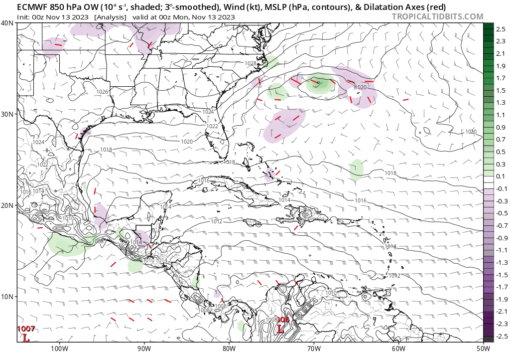
00z Euro… Low moving over GOM/FL more distinct before it appears to merge w/ our SW Caribbean low in the SW Atlantic… Maybe NHC going to tag this area, some ensembles starting to pickup on the GOM low becoming a TS before crossing or along FL coast…
0 likes
Hurricane Eye Experience: David 79, Irene 99, Frances 04, Jeanne 04, Wilma 05… Hurricane Brush Experience: Andrew 92, Erin 95, Floyd 99, Matthew 16, Irma 17, Ian 22, Nicole 22…
Re: Possible development in the SW Caribbean
Tropical Weather Outlook
NWS National Hurricane Center Miami FL
700 AM EST Tue Nov 14 2023
For the North Atlantic...Caribbean Sea and the Gulf of Mexico:
Southwestern Caribbean Sea:
An area of disturbed weather located over the southwestern Caribbean
Sea is currently associated with a broad area of showers and
thunderstorms. Environmental conditions appear favorable for
additional development of this system, and a tropical depression is
likely to form towards the end of this week while the system begins
moving northeastward across the western and central portions of the
Caribbean Sea. Interests in Cuba, Jamaica, Haiti, and the Dominican
Republic should monitor the progress of this system. Regardless of
development, this system has the potential to produce heavy rains
over portions of the Caribbean coast of Central America and the
Greater Antilles through the end of this week.
* Formation chance through 48 hours...low...10 percent.
* Formation chance through 7 days...high...70 percent.
$$
Forecaster Papin/Berg
0 likes
-
jlauderdal
- S2K Supporter
- Posts: 7240
- Joined: Wed May 19, 2004 5:46 am
- Location: NE Fort Lauderdale
- Contact:
Re: Possible development in the SW Caribbean
Blown Away wrote:[url]https://i.postimg.cc/8k96vR0W/ec-fast-ow850-watl-fh-24-144.gif [/url]
00z Euro… Low moving over GOM/FL more distinct before it appears to merge w/ our SW Caribbean low in the SW Atlantic… Maybe NHC going to tag this area, some ensembles starting to pickup on the GOM low becoming a TS before crossing or along FL coast…
Fascinating if it comes close to verifying. Regardless, the rainy season has returned to South Florida M-Th this week, prime time tomorrow into Thursday.
1 likes
Who is online
Users browsing this forum: No registered users and 220 guests