Texas Winter 2023-2024

Winter Weather Discussion

Moderator: S2k Moderators

Forum rules

The posts in this forum are NOT official forecast and should not be used as such. They are just the opinion of the poster and may or may not be backed by sound meteorological data. They are NOT endorsed by any professional institution or STORM2K.

Help Support Storm2K
Message
Author
User avatar
txtwister78
Category 5
Category 5
Posts: 1859
Joined: Wed Jan 30, 2019 12:56 pm
Location: San Antonio

Re: Texas Winter 2023-2024

#3061 Postby txtwister78 » Wed Jan 17, 2024 11:54 am

Cpv17 wrote:
HockeyTx82 wrote:
Edwards Limestone wrote:Ensembles still looking strong for significant rainfall for TX next week


What about cold? I keep seeing mentions of a possible ice storm for NTX.

So this past week we had the cold and moisture was in question, and now next week we have the moisture and cold in question?


Actually next week it warms up quite a bit and then we should enter a significant wet period. Don’t look for any significant cold to come back till very late this month or early February.


I would bet more on early February in my opinion. MJO has to swing into better phases to reload. NO PV to help mute that. That will take some time to do (couple weeks). Definitely ready for a break through along with some rainfall across SC TX.
4 likes   

Fifty Rock
Tropical Storm
Tropical Storm
Posts: 112
Joined: Mon Sep 11, 2023 10:08 am
Location: Albany, Texas

Re: Texas Winter 2023-2024

#3062 Postby Fifty Rock » Wed Jan 17, 2024 12:16 pm

Can someone post the expected rainfall totals across Texas next week?
0 likes   

User avatar
bubba hotep
S2K Supporter
S2K Supporter
Posts: 5837
Joined: Wed Dec 28, 2016 1:00 am
Location: Collin County Texas

Re: Texas Winter 2023-2024

#3063 Postby bubba hotep » Wed Jan 17, 2024 12:20 pm

DallasAg wrote:
Gotwood wrote:
Iceresistance wrote:I really hope there is no ice storm.

Even if there is some ice it seems like it will melt very quickly so I doubt there will be many issues.


This has the feel of one of those cases where surface temps will be borderline at best, and the temps at the cloud level will be way warmer and will just drag >32F air down with it. The raindrops themselves wouldn't be supercooled so it would be hard to accumulate much ice even with a 31-32 degree surface temp. So while technically you'd have "freezing rain" it's not going to be a crippling ice storm. Still lots of days out, but these systems that come in as cold air is retreating historically have that type of setup.


I wouldn't be surprised to see some areas start out as freezing rain, but I agree that temps will probably moderate enough to keep it from being more than a short-term novelty before it melts off.

Image

Image

Pivotal doesn't have ICON freezing rain totals, but it looks like similar areas start out as the other models

Image
3 likes   
Winter time post are almost exclusively focused on the DFW area.

User avatar
bubba hotep
S2K Supporter
S2K Supporter
Posts: 5837
Joined: Wed Dec 28, 2016 1:00 am
Location: Collin County Texas

Re: Texas Winter 2023-2024

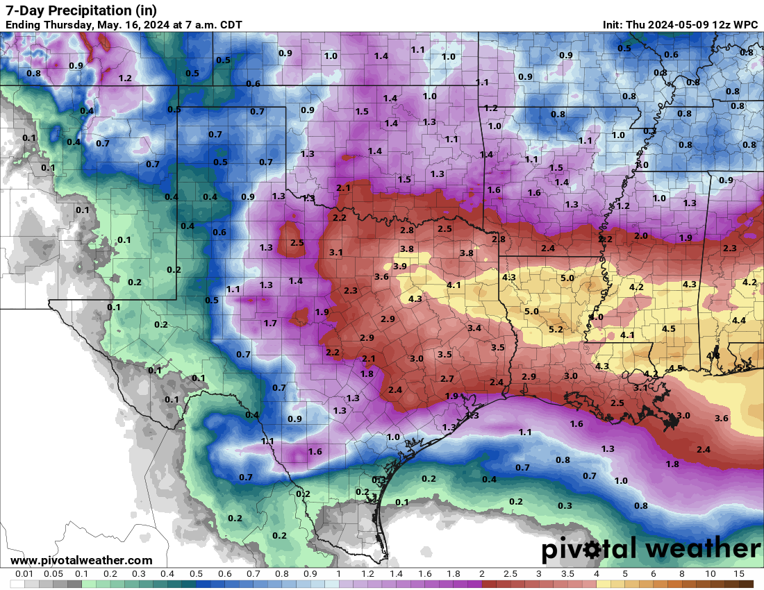
#3064 Postby bubba hotep » Wed Jan 17, 2024 12:21 pm

Fifty Rock wrote:Can someone post the expected rainfall totals across Texas next week?


WPC Forecast

Image
1 likes   
Winter time post are almost exclusively focused on the DFW area.

Stratton23
Category 5
Category 5
Posts: 2535
Joined: Fri Jul 21, 2023 10:59 pm
Location: Katy, Tx

Re: Texas Winter 2023-2024

#3065 Postby Stratton23 » Wed Jan 17, 2024 12:30 pm

Ill believe the rain fall when i see it, models have burnt me way too many times
4 likes   

User avatar
Cpv17
Category 5
Category 5
Posts: 4982
Joined: Wed Dec 07, 2016 2:24 pm
Location: Wharton/El Campo, TX

Re: Texas Winter 2023-2024

#3066 Postby Cpv17 » Wed Jan 17, 2024 1:25 pm

bubba hotep wrote:
Fifty Rock wrote:Can someone post the expected rainfall totals across Texas next week?


WPC Forecast

https://x-hv1.pivotalweather.com/maps/wpc/latest/wpc_qpf_168h_p.us_sc.png


That will go up.
0 likes   

rwfromkansas
Category 5
Category 5
Posts: 2627
Joined: Sat Aug 27, 2005 12:47 am
Location: North Fort Worth

Re: Texas Winter 2023-2024

#3067 Postby rwfromkansas » Wed Jan 17, 2024 1:49 pm

Unless it trends colder, even if it's freezing rain, it won't even cause tiny issues at 32 degrees.
2 likes   

User avatar
Iceresistance
Category 5
Category 5
Posts: 9288
Age: 21
Joined: Sat Oct 10, 2020 9:45 am
Location: Tecumseh, OK/Norman, OK

Re: Texas Winter 2023-2024

#3068 Postby Iceresistance » Wed Jan 17, 2024 1:52 pm

This is not one of the headfake SSWs, this is the real deal, and a big one as well.

Image
https://s13.gifyu.com/images/S06rw.png
4 likes   
Bill 2015 & Beta 2020

Winter 2020-2021 :cold:

All observations are in Tecumseh, OK unless otherwise noted.

Winter posts are focused mainly for Oklahoma & Texas.

Take any of my forecasts with a grain of salt, refer to the NWS, SPC, and NHC for official information

Never say Never with weather! Because ANYTHING is possible!

Stratton23
Category 5
Category 5
Posts: 2535
Joined: Fri Jul 21, 2023 10:59 pm
Location: Katy, Tx

Re: Texas Winter 2023-2024

#3069 Postby Stratton23 » Wed Jan 17, 2024 2:16 pm

Iceresistance did this SSWE just occur? Havent heard of any talk about one on social media
0 likes   

User avatar
Ntxw
Storm2k Moderator
Storm2k Moderator
Posts: 22787
Joined: Wed Oct 21, 2009 6:34 pm
Location: DFW, Texas

Re: Texas Winter 2023-2024

#3070 Postby Ntxw » Wed Jan 17, 2024 2:25 pm

Stratton23 wrote:Iceresistance did this SSWE just occur? Havent heard of any talk about one on social media


A wind reversal did occur yesterday/today, which means it was a major SSW technically. Propagation downward would typically be expected, in this case early to mid February. We'll have to watch AO response in a few weeks.

Image

Amy H Butler is the go to for all things SSW.

https://www.climate.gov/news-features/blogs/polar-vortex/polar-vortex-acting

This is one of those things where you have to view the strat PV from a much more complicated perspective. The strat-troposphere weakened part of the vortex has been disrupting the upper portion, this is part of the reason it's been cold. As the upper portion is disrupted it can't be the force to recover the lower portion, so there will be continued weakened state of the PV.
3 likes   
The above post and any post by Ntxw is NOT an official forecast and should not be used as such. It is just the opinion of the poster and may or may not be backed by sound meteorological data. It is NOT endorsed by any professional institution including Storm2k. For official information, please refer to NWS products.

  Help support Storm2K!
Help Support Storm2K

Itryatgolf
Category 1
Category 1
Posts: 305
Joined: Mon Jul 18, 2022 8:04 pm
Location: Jackson tn

Re: Texas Winter 2023-2024

#3071 Postby Itryatgolf » Wed Jan 17, 2024 2:39 pm

Ntxw wrote:
Stratton23 wrote:Iceresistance did this SSWE just occur? Havent heard of any talk about one on social media


A wind reversal did occur yesterday/today, which means it was a major SSW technically. Propagation downward would typically be expected, in this case early to mid February. We'll have to watch AO response in a few weeks.

https://i.imgur.com/wqKowXl.png

Amy H Butler is the go to for all things SSW.

https://www.climate.gov/news-features/blogs/polar-vortex/polar-vortex-acting

This is one of those things where you have to view the strat PV from a much more complicated perspective. The strat-troposphere weakened part of the vortex has been disrupting the upper portion, this is part of the reason it's been cold. As the upper portion is disrupted it can't be the force to recover the lower portion, so there will be continued weakened state of the PV.

SSW events are tricky. Fun when we get real cold and stormier from them. Not all are the same. I'm thinking of the first week in February before we get colder again imo. It kinda sucks to get the mjo in the warm phases for a while :grrr:
0 likes   

User avatar
Iceresistance
Category 5
Category 5
Posts: 9288
Age: 21
Joined: Sat Oct 10, 2020 9:45 am
Location: Tecumseh, OK/Norman, OK

Re: Texas Winter 2023-2024

#3072 Postby Iceresistance » Wed Jan 17, 2024 3:01 pm

Itryatgolf wrote:
Ntxw wrote:
Stratton23 wrote:Iceresistance did this SSWE just occur? Havent heard of any talk about one on social media


A wind reversal did occur yesterday/today, which means it was a major SSW technically. Propagation downward would typically be expected, in this case early to mid February. We'll have to watch AO response in a few weeks.

https://i.imgur.com/wqKowXl.png

Amy H Butler is the go to for all things SSW.

https://www.climate.gov/news-features/blogs/polar-vortex/polar-vortex-acting

This is one of those things where you have to view the strat PV from a much more complicated perspective. The strat-troposphere weakened part of the vortex has been disrupting the upper portion, this is part of the reason it's been cold. As the upper portion is disrupted it can't be the force to recover the lower portion, so there will be continued weakened state of the PV.

SSW events are tricky. Fun when we get real cold and stormier from them. Not all are the same. I'm thinking of the first week in February before we get colder again imo. It kinda sucks to get the mjo in the warm phases for a while :grrr:


MJO will get out of the warm phases, likely in February

Image
https://s13.gifyu.com/images/S065f.png
2 likes   
Bill 2015 & Beta 2020

Winter 2020-2021 :cold:

All observations are in Tecumseh, OK unless otherwise noted.

Winter posts are focused mainly for Oklahoma & Texas.

Take any of my forecasts with a grain of salt, refer to the NWS, SPC, and NHC for official information

Never say Never with weather! Because ANYTHING is possible!

User avatar
Texas Snow
S2K Supporter
S2K Supporter
Posts: 784
Joined: Mon Oct 19, 2015 12:06 pm
Location: N. Dallas & Cedar Creek Lake

Re: Texas Winter 2023-2024

#3073 Postby Texas Snow » Wed Jan 17, 2024 3:02 pm

DallasAg wrote:
This has the feel of one of those cases where surface temps will be borderline at best, and the temps at the cloud level will be way warmer and will just drag >32F air down with it. The raindrops themselves wouldn't be supercooled so it would be hard to accumulate much ice even with a 31-32 degree surface temp. So while technically you'd have "freezing rain" it's not going to be a crippling ice storm. Still lots of days out, but these systems that come in as cold air is retreating historically have that type of setup.


Told my wife this exact same thing on one of our 2 walks out in the amazing cold yesterday. Not concerned about this in North Texas at all.
0 likes   
"Don't let wishcastin get in the way of your forecastin"

Image

Brent
S2K Supporter
S2K Supporter
Posts: 38093
Age: 37
Joined: Sun May 16, 2004 10:30 pm
Location: Tulsa Oklahoma
Contact:

Re: Texas Winter 2023-2024

#3074 Postby Brent » Wed Jan 17, 2024 3:03 pm

Finally above freezing here after 5 days and it feels amazing. Sunday apparently ended up being the 12th coldest day on record here :double:

I'm not really worried about Monday much... At worst probably a few hours with an icy bridge or something. We're gonna warmup for sure unlike behind this last storm so yeah it's not gonna be anything crazy
1 likes   
#neversummer

User avatar
txtwister78
Category 5
Category 5
Posts: 1859
Joined: Wed Jan 30, 2019 12:56 pm
Location: San Antonio

Re: Texas Winter 2023-2024

#3075 Postby txtwister78 » Wed Jan 17, 2024 3:09 pm

3 likes   

User avatar
bubba hotep
S2K Supporter
S2K Supporter
Posts: 5837
Joined: Wed Dec 28, 2016 1:00 am
Location: Collin County Texas

Re: Texas Winter 2023-2024

#3076 Postby bubba hotep » Wed Jan 17, 2024 3:27 pm

1 likes   
Winter time post are almost exclusively focused on the DFW area.

User avatar
Portastorm
Storm2k Moderator
Storm2k Moderator
Posts: 9914
Age: 63
Joined: Fri Jul 11, 2003 9:16 am
Location: Round Rock, TX
Contact:

Re: Texas Winter 2023-2024

#3077 Postby Portastorm » Wed Jan 17, 2024 3:34 pm


I’m very excited about the prospects of desperately needed rainfall down here … bring it! Travis and Williamson counties are in severe/extreme drought conditions.
5 likes   
Any forecasts under my name are to be taken with a grain of salt. Get your best forecasts from the National Weather Service and National Hurricane Center.

weatherdude1108
Category 5
Category 5
Posts: 4228
Joined: Tue Dec 13, 2011 1:04 pm
Location: Northwest Austin/Cedar Park, TX

Re: Texas Winter 2023-2024

#3078 Postby weatherdude1108 » Wed Jan 17, 2024 4:15 pm

According to my weather station, we bottomed out at 15.6 degrees on Monday. Had some freezing drizzle, sleet, and flurries on Monday, most of which evaporated (sublimated) by Monday night.

Stayed below freezing from 12:15am Sunday to 10:55am today (Wednesday). Roughly 82 hours and 40 minutes at 32 degrees or below. Not 144 hours (record for Mabry). But long enough!!lol

Tired of watching dripping/covered pipes and making sure covered plants stay covered. :jacket: :froze: I'll keep covers on plants until Saturday morning and drip faucets without as much cover as this last event (low 20s Saturday morning instead of mid-teens).

We rescheduled our Kalahari visit for this Sunday to Monday (good choice). Looks like cold rain.
Anyway, looking forward to a good night's rest, and possibilities for significant rain next week! :rain: :rain: :rain:
0 likes   
The preceding post is NOT an official forecast, and should not be used as such. It is only the opinion of the poster and may or may not be backed by sound meteorological data. It is NOT endorsed by any professional institution including storm2k.org. For Official Information please refer to the NHC and NWS products.

Yukon Cornelius
S2K Supporter
S2K Supporter
Posts: 1798
Age: 41
Joined: Thu Dec 20, 2012 9:23 pm
Location: Dean, TX/Westcliffe, CO

Re: Texas Winter 2023-2024

#3079 Postby Yukon Cornelius » Wed Jan 17, 2024 4:25 pm

96 hours below freezing. The lowest temp was 4. Ready for the next one!
3 likes   
#neversummer

User avatar
CaptinCrunch
S2K Supporter
S2K Supporter
Posts: 8728
Age: 57
Joined: Mon Nov 03, 2003 4:33 pm
Location: Kennedale, TX (Tarrant Co.)

Re: Texas Winter 2023-2024

#3080 Postby CaptinCrunch » Wed Jan 17, 2024 4:41 pm

NWS FTW
Long Range Discussion

The break in colder temperatures will be short-lived as another
strong push of arctic air is expected across North and Central
Texas Thursday night. Although not as cold as the last arctic
blast, hazardous cold is still expected and it will be important
to remember the 4 P`s when preparing for cold temperatures:
people, pets, plants, and pipes.

Friday morning will start in the teens to low 20s across North
Texas and the mid to upper 20s across Central Texas. Strong
northerly winds at 15-20 mph gusting to 30 mph at times will allow
for wind chills in the single digits Friday morning, so bundle
up! With plentiful sunshine, most locations south of I-20 will
climb above freezing Friday afternoon, however there is a 40-50%
chance that locations along the Red River will struggle to get
above freezing through the entirety of Friday. Friday night into
Saturday morning will be the coldest period of the extended
forecast with widespread overnight lows in the teens. There is a
low (10%) chance that locations along the immediate Red River
Valley drop into the single digits Friday night. Saturday will
feature more cold conditions with afternoon highs in the 30s
across the region. By late Saturday, arctic high pressure will
move east of the region allowing for a prolonged period of strong
warm/moist advection to begin into early next week.

Broad-scale troughing will develop across the western CONUS early
next week placing North and Central Texas under persistent
southwesterly flow aloft. A series of shortwave disturbances
ejecting out ahead of the main trough axis and increasing
isentropic ascent atop a cool near-surface airmass will lead to
increased rain chances the latter half of Sunday through at least
the middle of next week. Anomalously high moisture forecast by
long-range models suggests the potential for heavy rainfall,
especially across our Central Texas counties where modest amounts
of MUCAPE may be present. The first round of widespread rainfall
looks to occur Sunday night into Monday with periodic chances for
rain through much of next week. Although most of the region is
expected to stay above freezing through this rain event, there is
a 10-20% chance that locations along the Red River could see
freezing rain Sunday night into Monday morning.

Rainfall totals through next Wednesday will average 1-2.5 inches
across most of North and Central Texas, with lesser amounts west
of Highway 281. As mentioned in the previous paragraph, our
Central Texas counties will likely contain the greatest heavy
rainfall potential. There is a 30-40% chance that the Brazos
Valley counties see 3+ inches through midweek next week.

Langfeld
1 likes   


Return to “Winter Weather”

Who is online

Users browsing this forum: No registered users and 9 guests