Texas Winter 2023-2024
Moderator: S2k Moderators
Forum rules
 The posts in this forum are NOT official forecast and should not be used as such. They are just the opinion of the poster and may or may not be backed by sound meteorological data. They are NOT endorsed by any professional institution or STORM2K.

The posts in this forum are NOT official forecast and should not be used as such. They are just the opinion of the poster and may or may not be backed by sound meteorological data. They are NOT endorsed by any professional institution or STORM2K.
-
Stratton23
- Category 5

- Posts: 3578
- Joined: Fri Jul 21, 2023 10:59 pm
- Location: Katy, Tx
Re: Texas Winter 2023-2024
Harp.1 its already starting to show up somewhat in the OP guidance, but at this range the only guidance that matters right now are the ensembles
3 likes
-
CaptinCrunch

- S2K Supporter

- Posts: 8785
- Age: 58
- Joined: Mon Nov 03, 2003 4:33 pm
- Location: Kennedale, TX (Tarrant Co.)
Re: Texas Winter 2023-2024
AFD NWS FTW
"LONG TERM"
As discussed in previous discussions, better rain and storm
chances arrive over the weekend as a series of upper level
disturbances moves across the southern Plains. The lingering
surface boundary should provide additional ascent for slightly
higher coverage of showers and storms, especially on Sunday.
While there`s still some uncertainties in the track, timing, and
speed of the main trough, latest suite of ensemble models are
beginning to show less spread between them. At this time, the
most likely scenario appears to be the one where many locations
will see at least measurable rain but the highest rain chances
will be for areas along and east of I-35. However, rainfall
totals will be on the lower side; even for our most eastern zones
where less than 1 inch of rain is currently forecast. Guidance
shows only a probability between 20-30% of exceeding 1 inch over
these locations.
In addition to the rain chances, we should see temperatures go
back to near normal by the end of the weekend into early next
week. Breezy northerly wind will prevail keeping our highs in the
50s and 60s and lows in the 30s and 40s.
Sanchez
As you can see next week should start the trend to normal/below normal temps and perhaps a wetter pattern. This morning was cooler than forecast, I even had some lite ice on the windshield of the 4Runner.
0 likes

Re: Texas Winter 2023-2024
I also had some light frost on my windshield in Longview. Nice and crisp.
1 likes

-
Stratton23
- Category 5
- Posts: 3578
- Joined: Fri Jul 21, 2023 10:59 pm
- Location: Katy, Tx
Re: Texas Winter 2023-2024
Harp.1 that means nothing, ensembles look great for colder weather, the operational models are going to struggle with this pattern as their are a lot of moving parts that will cause model chaos
2 likes
-
Brent
- S2K Supporter
- Posts: 38778
- Age: 37
- Joined: Sun May 16, 2004 10:30 pm
- Location: Tulsa Oklahoma
- Contact:
Re: Texas Winter 2023-2024
Through the 20th my coldest high is 49 so we've got a long way to go
1 likes
#neversummer
-
orangeblood
- S2K Supporter
- Posts: 3895
- Joined: Tue Dec 15, 2009 6:14 pm
- Location: Fort Worth, TX
Re: Texas Winter 2023-2024
Stratton23 wrote:Harp.1 that means nothing, ensembles look great for colder weather, the operational models are going to struggle with this pattern as their are a lot of moving parts that will cause model chaos
Unfortunately it appears to be just a brief window of cold than Pacific Air barn door opens again...Ensembles past day 10 not looking good!
This is not what you want to see for cold, plenty of moisture but source region getting overwhelmed by Pacific Air.

0 likes
-
Stratton23
- Category 5
- Posts: 3578
- Joined: Fri Jul 21, 2023 10:59 pm
- Location: Katy, Tx
Re: Texas Winter 2023-2024
Orangeblood I respectfully disagree with this , the GEFS is alone with that pacific air stuff , ensembles lock in below average temps for an extended period, this does not look to be a short lived cold snap in my opinion ( not calling for extreme cold though) , GEPS and EPS certainly dont agree with that idea as they both keep ridging over alaska, i guess we will see which ensemble is right lol
Last edited by Stratton23 on Tue Feb 06, 2024 2:37 pm, edited 1 time in total.
0 likes
-
Iceresistance

- Category 5
- Posts: 9608
- Age: 22
- Joined: Sat Oct 10, 2020 9:45 am
- Location: Tecumseh, OK/Norman, OK
Re: Texas Winter 2023-2024
1 likes
Bill 2015 & Beta 2020
Winter 2020-2021
All observations are in Tecumseh, OK unless otherwise noted.
Winter posts are focused mainly for Oklahoma & Texas.
Take any of my forecasts with a grain of salt, refer to the NWS, SPC, and NHC for official information
Never say Never with weather! Because ANYTHING is possible!
Winter 2020-2021
All observations are in Tecumseh, OK unless otherwise noted.
Winter posts are focused mainly for Oklahoma & Texas.
Take any of my forecasts with a grain of salt, refer to the NWS, SPC, and NHC for official information
Never say Never with weather! Because ANYTHING is possible!
Re: Texas Winter 2023-2024
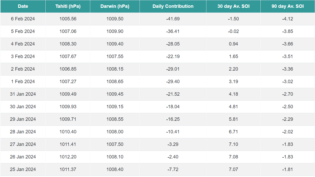
Iceresistance wrote:SOI Crash
https://s13.gifyu.com/images/SCRAM.png
https://s13.gifyu.com/images/SCRAM.png
Can you explain please?
0 likes
-
txtwister78

- Category 5
- Posts: 2238
- Joined: Wed Jan 30, 2019 12:56 pm
- Location: San Antonio
Re: Texas Winter 2023-2024
Harp.1 wrote:This place got dead. Never a good sign…
My take is you can only say the same thing so many times before it becomes tired and obviously a little too repetitive.
Is it going to turn colder? Yes, I believe it will. The question in my opinion becomes how cold relative to the averages for this time of year. That's important in that the later you get into winter across the south, the higher the norms as it relates to temps (sun angle etc).
The other key to this pattern (if you want winter precip) is you need an active southern jet to establish itself and we're likely going to have that in place mid to late month.
To get snow you don't have to get the January type arctic outbreak we experienced several weeks ago. All you need is dynamic system with "enough" cold air around and you can get some big events out of those setups, but we're still a few weeks out and so we wait. The devil is always in the details down in this region when it comes to winter precipitation and cold mixing in but at least it's a chance.
Latest Euro Ensemble for example is going toward what the Candian Ensemble has been showing for the past several runs. That's a pretty decent signal for what looks to be at a minimum an "interesting" setup to track down the road.

7 likes
-
orangeblood
- S2K Supporter
- Posts: 3895
- Joined: Tue Dec 15, 2009 6:14 pm
- Location: Fort Worth, TX
Re: Texas Winter 2023-2024
Stratton23 wrote:Orangeblood I respectfully disagree with this , the GEFS is alone with that pacific air stuff , ensembles lock in below average temps for an extended period, this does not look to be a short lived cold snap in my opinion ( not calling for extreme cold though) , GEPS and EPS certainly dont agree with that idea as they both keep ridging over alaska, i guess we will see which ensemble is right lol
Need some Arctic HP's to get into the central US before this jet crashes into the west coast
0 likes
-
Stratton23
- Category 5
- Posts: 3578
- Joined: Fri Jul 21, 2023 10:59 pm
- Location: Katy, Tx
Re: Texas Winter 2023-2024
orangeblood that i do agree with, but as twister78 mentioned above all it really is going to take a is a dynamic system to take advantage of whatever cold air is available, id prefer marginal cold air ( upper 20’s) than bitter cold and then the precipitation ends up getting completely suppressed and we end up dry
1 likes
-
Portastorm

- Storm2k Moderator

- Posts: 9955
- Age: 63
- Joined: Fri Jul 11, 2003 9:16 am
- Location: Round Rock, TX
- Contact:
Re: Texas Winter 2023-2024
Stratton23 wrote:orangeblood that i do agree with, but as twister78 mentioned above all it really is going to take a is a dynamic system to take advantage of whatever cold air is available, id prefer marginal cold air ( upper 20’s) than bitter cold and then the precipitation ends up getting completely suppressed and we end up dry
Yes! If you're not looking for a longer term pattern with multiple winter precip threats ... a good upper level low and even marginally cold temps will do the trick for snowfall. Some of the better snow events in Texas that I have seen over the years have happened this way.
1 likes
Any forecasts under my name are to be taken with a grain of salt. Get your best forecasts from the National Weather Service and National Hurricane Center.
-
Stratton23
- Category 5
- Posts: 3578
- Joined: Fri Jul 21, 2023 10:59 pm
- Location: Katy, Tx
Re: Texas Winter 2023-2024
The 18z GFS is an example of the right setup that you want to see, got a classic gulf low developing at hour 216-240 with plenty of moisture, marginal cold air for some frozen precipitation, just need temps to be colder on that run, then you would have a very good setup for a big event
1 likes

Re: Texas Winter 2023-2024
Harp.1 wrote:Iceresistance wrote:SOI Crash
https://s13.gifyu.com/images/SCRAM.png
https://s13.gifyu.com/images/SCRAM.png
Can you explain please?
Negative SOI is more favorable for El Nino.
2 likes
-
Brent
- S2K Supporter
- Posts: 38778
- Age: 37
- Joined: Sun May 16, 2004 10:30 pm
- Location: Tulsa Oklahoma
- Contact:
Re: Texas Winter 2023-2024
Now the icon has snow here Sunday Monday
Tulsa did mention it's possible
Uncertainty continues for the weekend forecast and the eventual
passage of upper level system. There remains some guidance that
would suggests a possible transition to winter weather as the
system departs Sunday night or early Monday morning, however given
the lack of antecedent cold air and the lingering inconsistencies
in model solutions and large ensemble spread, will keep any
mention of snow out of the forecast at this time.
1 likes
#neversummer
-
Stratton23
- Category 5
- Posts: 3578
- Joined: Fri Jul 21, 2023 10:59 pm
- Location: Katy, Tx
Re: Texas Winter 2023-2024
Operational GFS and CMC 00z runs are starting to see the cold now
3 likes
-
jasons2k

- Storm2k Executive

- Posts: 8290
- Age: 52
- Joined: Wed Jul 06, 2005 12:32 pm
- Location: The Woodlands, TX
Re: Texas Winter 2023-2024
Stratton23 wrote:The 18z GFS is an example of the right setup that you want to see, got a classic gulf low developing at hour 216-240 with plenty of moisture, marginal cold air for some frozen precipitation, just need temps to be colder on that run, then you would have a very good setup for a big event
You keep holding out hope in that timeframe. The long range models, especially the GFS are notorious for this.
It’s February 7th already. Where’s our Valentine’s snowstorm??
As some other posters have pointed out, the constant hype in the long range (when others know better) starts to get old.
2 likes

Re: Texas Winter 2023-2024
Oh dear, Mr. Cosgrove…
“Starting soon, a genuine cold wave that will be hard to get rid of.”
https://clearskyweather.com/2024/02/07/ ... et-rid-of/
“It would be wise to do a walk-through on why the weather pattern will be colder than what we have experienced nationally since mid-January. This is not February 2021 redux; rather, it is a more spread-out event that will support perhaps two ice and snow events along the southern and eastern tier of the lower 48 states. I cannot be any more specific than that, but the similarity of the numerical models and analogs is impressive.
Most likely time frame: February 12 – March 7. There could be a small break of moderation involved somewhere. But climatology of -EPO/-AO/-NAO blocking scenarios basically involves temperature averages in most of the USA being below normal. And in the case of the south central and Dixie states, well below average.
Storm threats: judging by the 500MB height anomalies on the various models, February 12 – 14 and February 17 – 20. Track probability is greatest along a South Texas – Florida – Nova Scotia arc. The second threat appears to be greater and would involve a good deal of frozen types to the left of the path of the disturbances.
Strongest cold potential: February 16 – 20 from the High Plains to the Gulf and East Coast.
Clues in the synoptic pattern that the cold/snow risks should not be taken lightly: even with so much ridging, a gap in the upper flow is present which will allow for cross-polar flow. Also, note that the Arctic jet stream dips below the Great Lakes with recurrent cAk vortex formation in Ontario, James Bay, and Quebec. Also note the evolution of a storm aloft that gets into Baja California. Very low in latitude, redevelopment should be below the TX Gulf Coast. That trajectory is a colder and wetter one for the Lone Star State, the Deep South and Eastern Seaboard.“
3 likes
Tammie - Sherman TX
Who is online
Users browsing this forum: No registered users and 115 guests