
I also plotted the OISST data and added 2005 and 2010 there for comparison. 2024 is nearly 2 month ahead of 2005/2010 and 4 month ahead of climo
Moderator: S2k Moderators


zzzh wrote:
https://i.imgur.com/9yJAchD.png
I also plotted the OISST data and added 2005 and 2010 there for comparison. 2024 is nearly 2 month ahead of 2005/2010 and 4 month ahead of climo


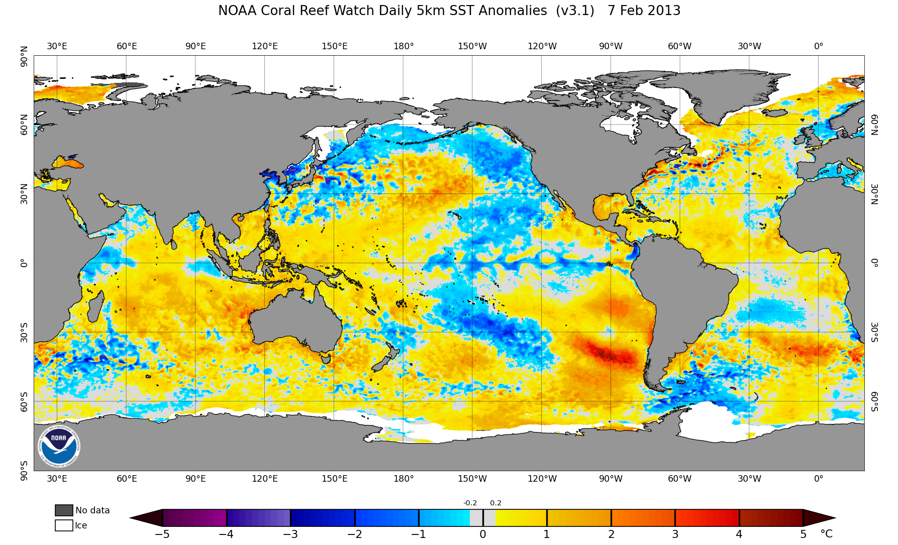
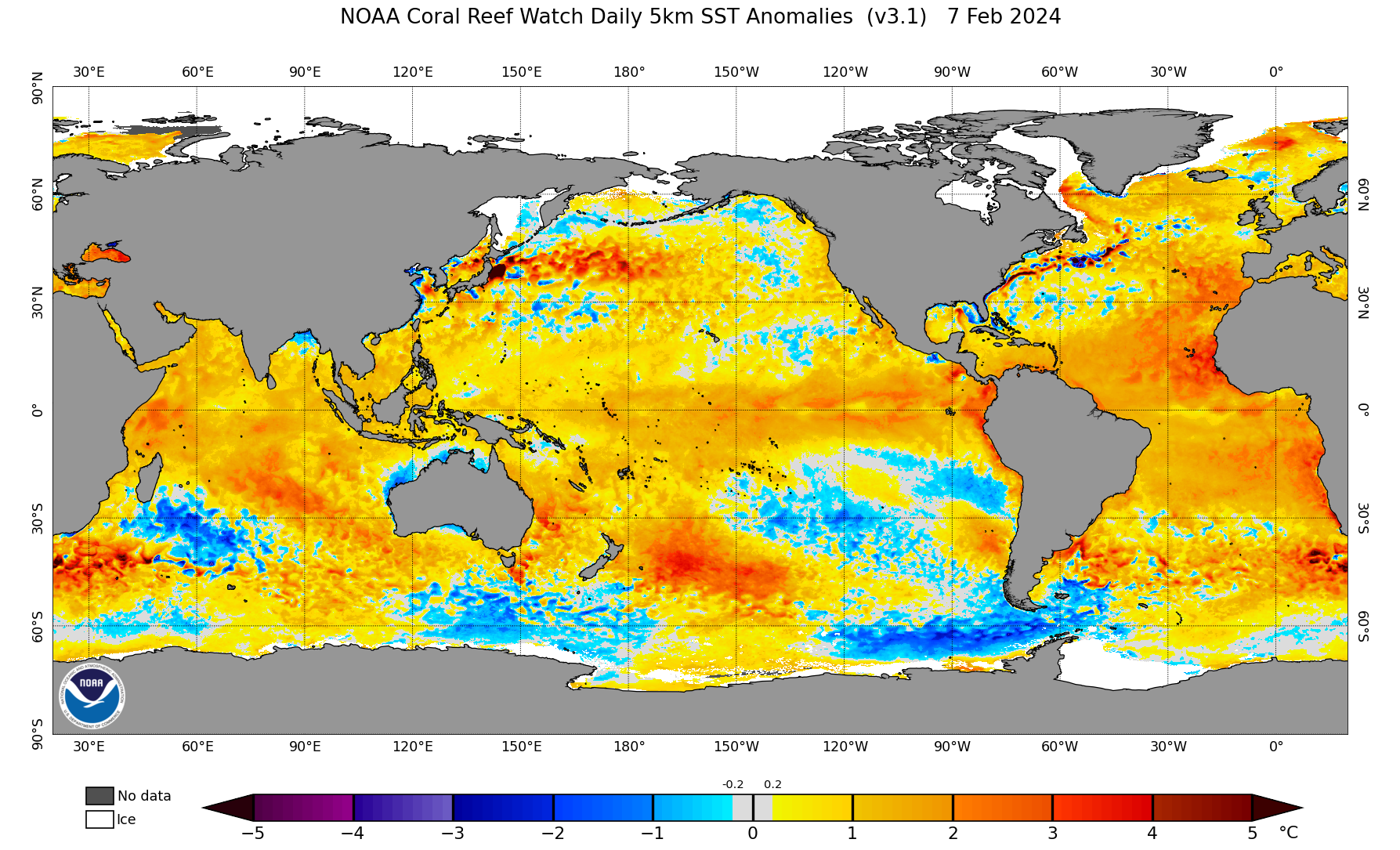
 Current it’s 1.2 degrees warmer than normal - Yikes….Remember the years when it would be a huge milestone to hit .8 degrees warmer than normal


Teban54 wrote:Something to keep in mind: There's still a high degree of uncertainty regarding steering patterns and thus tracks, as shown by NMME members.
(A comment also mentions model skills in predicting track patterns via precip anomalies seem to have improved, with 2022 and 2023 as examples.)
https://twitter.com/AndyHazelton/status/1755215927279247375?s=20


cycloneye wrote:Teban54 wrote:Something to keep in mind: There's still a high degree of uncertainty regarding steering patterns and thus tracks, as shown by NMME members.
(A comment also mentions model skills in predicting track patterns via precip anomalies seem to have improved, with 2022 and 2023 as examples.)
https://twitter.com/AndyHazelton/status/1755215927279247375?s=20
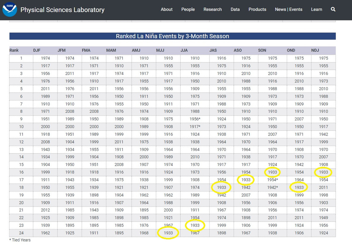
In terms of tracks, the analog 1933 that has been mentioned a lot on social media, had different tracks.
https://i.imgur.com/AkOYcfw.jpeg

cycloneye wrote:Not so fast the warming in MDR?
https://twitter.com/catinsight/status/1756024360916193412
https://twitter.com/AndyHazelton/status/1756024736578945387

cycloneye wrote:Not so fast the warming in MDR?
https://twitter.com/catinsight/status/1756024360916193412
https://twitter.com/AndyHazelton/status/1756024736578945387
cycloneye wrote:The C35 looks the sane as NMME and CanSips.
https://twitter.com/AndyHazelton/status/1756307161213251667
https://twitter.com/AndyHazelton/status/1756308104201793901
LemieT wrote:cycloneye wrote:The C35 looks the sane as NMME and CanSips.
https://twitter.com/AndyHazelton/status/1756307161213251667
https://twitter.com/AndyHazelton/status/1756308104201793901
I think it's safe to say even at this early stage that 2024 should turn out to be an active year. Let's leave the *hyperactive* discussion off the table for now but barring a really drastic and completely unforeseen (THC collapse, "wave-breaking" I'm looking at you), it's hard to see how this season doesn't produce healthy numbers.
For me a larger takeaway from all that we have seen is at least we should all be preparing for increased heavy precip. events. The Caribbean islands especially should make sure flood preps are in place, enacted or updated as a matter of urgency. Even if no named storms impact the region, based on what the models are currently suggesting (wet Caribbean look), we need to be on the lookout for high impact rain events this year.
cycloneye wrote:LemieT wrote:cycloneye wrote:The C35 looks the sane as NMME and CanSips.
https://twitter.com/AndyHazelton/status/1756307161213251667
https://twitter.com/AndyHazelton/status/1756308104201793901
I think it's safe to say even at this early stage that 2024 should turn out to be an active year. Let's leave the *hyperactive* discussion off the table for now but barring a really drastic and completely unforeseen (THC collapse, "wave-breaking" I'm looking at you
For me a larger takeaway from all that we have seen is at least we should all be preparing for increased heavy precip. events. The Caribbean islands especially should make sure flood preps are in place, enacted or updated as a matter of urgency. Even if no named storms impact the region, based on what the models are currently suggesting (wet Caribbean look), we need to be on the lookout for high impact rain events this year.
Also another drastic, that El NIño stays thru the summer.Agree 100% about the Caribbean.
LemieT wrote:cycloneye wrote:The C35 looks the sane as NMME and CanSips.
https://twitter.com/AndyHazelton/status/1756307161213251667
https://twitter.com/AndyHazelton/status/1756308104201793901
I think it's safe to say even at this early stage that 2024 should turn out to be an active year. Let's leave the *hyperactive* discussion off the table for now but barring something really drastic and completely unforeseen (THC collapse, "wave-breaking" I'm looking at you
For me a larger takeaway from all that we have seen is at least we should all be preparing for increased heavy precip. events. The Caribbean islands especially should make sure flood preps are in place, enacted or updated as a matter of urgency. Even if no named storms impact the region, based on what the models are currently suggesting (wet Caribbean look), we need to be on the lookout for high impact rain events this year.


Users browsing this forum: gib and 161 guests


