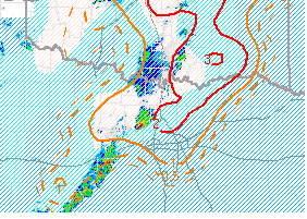
Mesoscale Discussion 0328
NWS Storm Prediction Center Norman OK
0553 PM CDT Mon Apr 01 2024
Areas affected...much of central OK into northern TX
Concerning...Tornado Watch 65...
Valid 012253Z - 020030Z
The severe weather threat for Tornado Watch 65 continues.
SUMMARY...The severe threat continues across Tornado Watch 65. Very
large (2-3 inch diameter) hail appears to be the main threat, though
a few tornadoes remain possible with the more dominant supercells.
DISCUSSION...Deep-layer ascent from the ejecting mid-level trough is
overspreading the southern Plains, likely contributing to the recent
uptick in convective coverage and intensity over southwestern into
central OK. Despite persistent cloud cover and the presence of a
broader rain shield overspreading western into central OK, adequate
deep-layer shear and overall buoyancy will still support an
appreciable severe threat into the evening. The 19Z OUN observed
sounding showed 9 C/km mid-level lapse rates atop a capping
inversion, which has been gradually eroding with time. Regional
VADs, the 19Z observed sounding, and 22Z mesoanalysis, all depict
elongated hodographs, with over 70 kts of effective bulk shear
present. The very steep mid-level lapse rates and strong effective
bulk shear all suggest that large hail (some stones falling within
the 2-3 inch diameter range) will be possible with any more
persistent, mature supercells that can develop. Despite current
meager low-level shear, an increase in low-level jet intensity may
boost SRH later this evening, potentially accompanied by an
increasing tornado threat, especially in eastern OK.
..Squitieri.. 04/01/2024
...Please see http://www.spc.noaa.gov for graphic product...
ATTN...WFO...TSA...FWD...OUN...SJT...


