Texas Spring 2024
Moderator: S2k Moderators
Forum rules

The posts in this forum are NOT official forecast and should not be used as such. They are just the opinion of the poster and may or may not be backed by sound meteorological data. They are NOT endorsed by any professional institution or STORM2K.
-
Brent
- S2K Supporter

- Posts: 38748
- Age: 37
- Joined: Sun May 16, 2004 10:30 pm
- Location: Tulsa Oklahoma
- Contact:
Re: Texas Spring 2024
Tbh I don't know what to believe anymore. We were told we would have a good winter we were told after the eclipse it would be stormy. It's rained like 5 drops here total so no I don't believe anything about Monday even much less the summer at this point. I mean I'm hoping for the best with the summer but they've been wrong about everything this year
0 likes
#neversummer
-
rwfromkansas
- Category 5

- Posts: 3034
- Joined: Sat Aug 27, 2005 12:47 am
- Location: North Fort Worth
Re: Texas Spring 2024
Well, one good note is that the lakes are doing better than I thought except for Bridgeport and Lake Worth. But, around Abilene they are still struggling.
0 likes

Re: Texas Spring 2024
Brent wrote:Tbh I don't know what to believe anymore. We were told we would have a good winter we were told after the eclipse it would be stormy. It's rained like 5 drops here total so no I don't believe anything about Monday even much less the summer at this point. I mean I'm hoping for the best with the summer but they've been wrong about everything this year
Yeah I feel like there have been a lot of busts around lately.
1 likes

Re: Texas Spring 2024
Have y’all heard about how much rain they got north of the Beaumont area? Incredible 
0 likes
Re: Texas Spring 2024
Brent wrote:Tbh I don't know what to believe anymore. We were told we would have a good winter we were told after the eclipse it would be stormy. It's rained like 5 drops here total so no I don't believe anything about Monday even much less the summer at this point. I mean I'm hoping for the best with the summer but they've been wrong about everything this year
I just picked up 3.19” early this morning.
1 likes
-
Iceresistance

- Category 5
- Posts: 9588
- Age: 22
- Joined: Sat Oct 10, 2020 9:45 am
- Location: Tecumseh, OK/Norman, OK
Re: Texas Spring 2024
April 15th could become a major problem
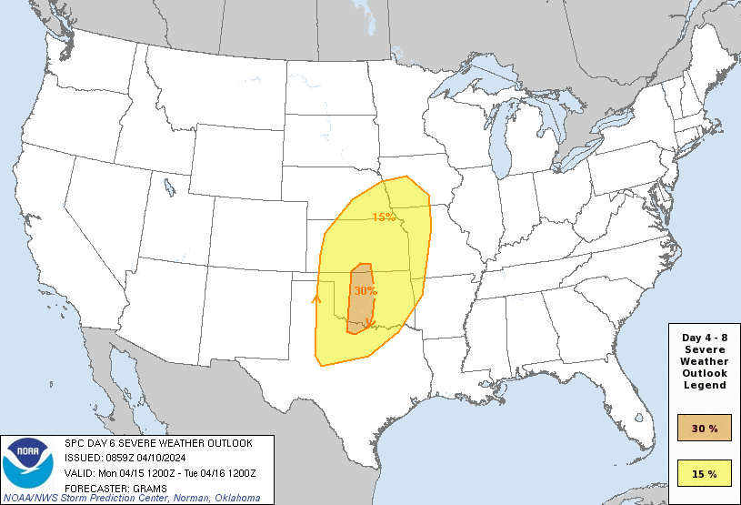
https://s9.gifyu.com/images/SZpof.gif
Strong wording from the SPC already
https://s9.gifyu.com/images/SZpof.gif
Strong wording from the SPC already
The actual severe weather setup appears substantial. Air mass
modification will ensue northward from the western Gulf on D3, with
multiple days to improve the low-level moisture profile amid well
above-normal surface temperatures and a pronounced elevated mixed
layer. With the likely flow field amplification through the
troposphere, all ingredients appear present for a significant severe
weather day on D6/Monday. The areal uncertainty of the synoptic
features is the primary limiting factor. For now, have added a
confined 30 percent highlight to indicate the higher-end potential
and the most probable corridor, while broadening the previous 15
percent area.
1 likes
Bill 2015 & Beta 2020
Winter 2020-2021
All observations are in Tecumseh, OK unless otherwise noted.
Winter posts are focused mainly for Oklahoma & Texas.
Take any of my forecasts with a grain of salt, refer to the NWS, SPC, and NHC for official information
Never say Never with weather! Because ANYTHING is possible!
Winter 2020-2021
All observations are in Tecumseh, OK unless otherwise noted.
Winter posts are focused mainly for Oklahoma & Texas.
Take any of my forecasts with a grain of salt, refer to the NWS, SPC, and NHC for official information
Never say Never with weather! Because ANYTHING is possible!
-
rwfromkansas
- Category 5
- Posts: 3034
- Joined: Sat Aug 27, 2005 12:47 am
- Location: North Fort Worth
Re: Texas Spring 2024
Poured for a bit, but the storms just sit and then die out, so it's a bit frustrating they don't advance further. I was on the edge so it only rained for a bit, but I will take it. Lol. Did rain hard!
0 likes
-
mmmmsnouts
- Tropical Storm

- Posts: 216
- Joined: Tue Sep 05, 2023 10:04 pm
- Location: Arlington, TX
Re: Texas Spring 2024
Absolutely hilarious donut hole on radar across eastern Tarrant and DFW so none of this flooding in Dallas will officially "count." I'm in Hurst right now and the horizons are dark in all four directions but sprinkles at most overhead.
1 likes
-
rwfromkansas
- Category 5
- Posts: 3034
- Joined: Sat Aug 27, 2005 12:47 am
- Location: North Fort Worth
-
bubba hotep

- S2K Supporter
- Posts: 6014
- Joined: Wed Dec 28, 2016 1:00 am
- Location: Collin County Texas
Re: Texas Spring 2024
We got slammed out here in Collin County. It's been pouring all day.
1 likes
Winter time post are almost exclusively focused on the DFW area.
-
HockeyTx82
- S2K Supporter
- Posts: 2793
- Joined: Tue Oct 27, 2009 11:17 am
- Location: Ponder, TX
Re: Texas Spring 2024
Has anyone mentioned the severe potential next Monday, the 15th..... yikes! Some strong wording.
0 likes
Don't hold me accountable for anything I post on this forum. Leave the real forecasting up to the professionals.
Location: Ponder, TX (all observation posts are this location unless otherwise noted)
Location: Ponder, TX (all observation posts are this location unless otherwise noted)
-
Brent
- S2K Supporter
- Posts: 38748
- Age: 37
- Joined: Sun May 16, 2004 10:30 pm
- Location: Tulsa Oklahoma
- Contact:
Re: Texas Spring 2024
HockeyTx82 wrote:Has anyone mentioned the severe potential next Monday, the 15th..... yikes! Some strong wording.
It's been mentioned above
Our met mentioned Tuesday too in the same post with a siren
0 likes
#neversummer
-
bubba hotep
- S2K Supporter
- Posts: 6014
- Joined: Wed Dec 28, 2016 1:00 am
- Location: Collin County Texas
Re: Texas Spring 2024
18z GFS keeps the wet pattern going

2 likes
Winter time post are almost exclusively focused on the DFW area.
Re: Texas Spring 2024
cstrunk wrote:Ended up with 5.93" total from Monday evening through yesterday afternoon. Added another 0.87" this morning.
Could get another 1-2" this afternoon as the low swings by.
Looks like the evening rain has finally ended. 3 day storm total was 7.08".
2 likes
-
Brent
- S2K Supporter
- Posts: 38748
- Age: 37
- Joined: Sun May 16, 2004 10:30 pm
- Location: Tulsa Oklahoma
- Contact:
Re: Texas Spring 2024
bubba hotep wrote:18z GFS keeps the wet pattern going
https://m1o.pivotalweather.com/maps/models/gfs/2024041018/384/qpf_acc-imp.us_sc.png
I see the Tulsa rain hole is now a permanent fixture on the GFS

0 likes
#neversummer
-
Iceresistance
- Category 5
- Posts: 9588
- Age: 22
- Joined: Sat Oct 10, 2020 9:45 am
- Location: Tecumseh, OK/Norman, OK
Re: Texas Spring 2024
Okay, this is actually starting to get concerning
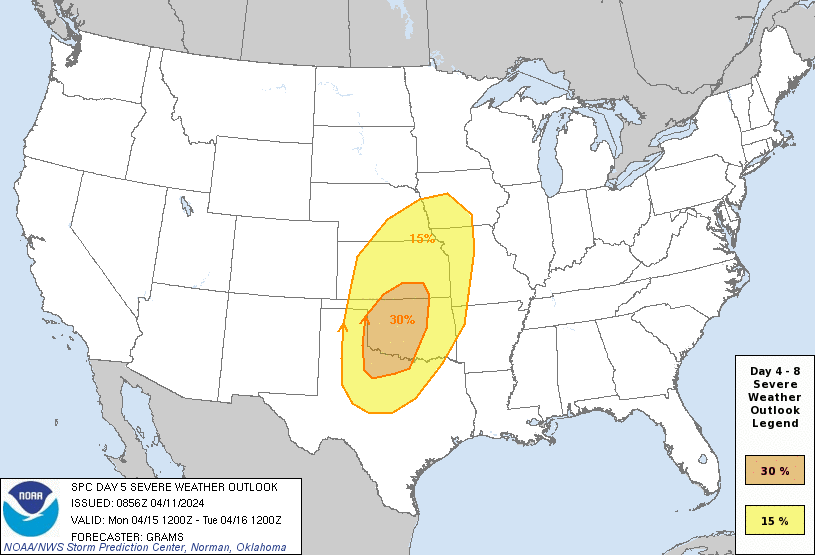
https://s12.gifyu.com/images/SZHtM.gif
SPC has some VERY STRONG wording for this
https://s12.gifyu.com/images/SZHtM.gif
SPC has some VERY STRONG wording for this
...Significant severe weather episode possible late afternoon and
evening on Monday...
A mid/upper low over the central CA vicinity at 12Z Sunday should
evolve into an open wave as it ejects across the Southwest and into
the central Great Plains by around Tuesday morning. As it crosses
the Rockies onto the High Plains, the tropospheric flow field will
amplify with substantial lee cyclogenesis in the central High Plains
on Monday afternoon. While a moderate amount of spread persists
across respective ensemble systems, 00Z deterministic runs have
converged towards greater agreement with the aforementioned scenario
through D5, with progressively lower predictability in D6-8.
With about 3 days of persistent low-level moisture modification from
the western Gulf beneath an extensive elevated mixed layer, the
northern extent of mid 60s surface dew points should reach into most
of OK east of the dryline by Monday afternoon. Late afternoon
thunderstorm initiation along the dryline appears probable in the
eastern TX Panhandle/western north TX to western OK vicinity, within
a kinematic and thermodynamic profile favorable for strong
supercells. Convective development will blossom both south and
especially north extent during the evening across the central and
southern Great Plains. For this outlook, have expanded the 30
percent area to highlight the greater spatial confidence in a
substantial severe weather episode.
Despite increasing predictability concerns and the impact of prior
day convection, very strong flow fields should persist into at least
the first half of D6/Tuesday as a deep surface cyclone pivots
northeast towards the Upper MS Valley vicinity. While instability
will be weaker compared to Monday, organized severe potential is
evident within an arc from a portion of the Upper MS Valley to the
Mid-South.
0 likes
Bill 2015 & Beta 2020
Winter 2020-2021
All observations are in Tecumseh, OK unless otherwise noted.
Winter posts are focused mainly for Oklahoma & Texas.
Take any of my forecasts with a grain of salt, refer to the NWS, SPC, and NHC for official information
Never say Never with weather! Because ANYTHING is possible!
Winter 2020-2021
All observations are in Tecumseh, OK unless otherwise noted.
Winter posts are focused mainly for Oklahoma & Texas.
Take any of my forecasts with a grain of salt, refer to the NWS, SPC, and NHC for official information
Never say Never with weather! Because ANYTHING is possible!
Re: Texas Spring 2024
Iceresistance wrote:Okay, this is actually starting to get concerning
https://s12.gifyu.com/images/SZHtM.gif
https://s12.gifyu.com/images/SZHtM.gif
SPC has some VERY STRONG wording for this...Significant severe weather episode possible late afternoon and
evening on Monday...
A mid/upper low over the central CA vicinity at 12Z Sunday should
evolve into an open wave as it ejects across the Southwest and into
the central Great Plains by around Tuesday morning. As it crosses
the Rockies onto the High Plains, the tropospheric flow field will
amplify with substantial lee cyclogenesis in the central High Plains
on Monday afternoon. While a moderate amount of spread persists
across respective ensemble systems, 00Z deterministic runs have
converged towards greater agreement with the aforementioned scenario
through D5, with progressively lower predictability in D6-8.
With about 3 days of persistent low-level moisture modification from
the western Gulf beneath an extensive elevated mixed layer, the
northern extent of mid 60s surface dew points should reach into most
of OK east of the dryline by Monday afternoon. Late afternoon
thunderstorm initiation along the dryline appears probable in the
eastern TX Panhandle/western north TX to western OK vicinity, within
a kinematic and thermodynamic profile favorable for strong
supercells. Convective development will blossom both south and
especially north extent during the evening across the central and
southern Great Plains. For this outlook, have expanded the 30
percent area to highlight the greater spatial confidence in a
substantial severe weather episode.
Despite increasing predictability concerns and the impact of prior
day convection, very strong flow fields should persist into at least
the first half of D6/Tuesday as a deep surface cyclone pivots
northeast towards the Upper MS Valley vicinity. While instability
will be weaker compared to Monday, organized severe potential is
evident within an arc from a portion of the Upper MS Valley to the
Mid-South.
Looks like the worse of it might be west of you.
0 likes


Re: Texas Spring 2024
Timing and storm mode, per usual, can dictate how much of an outbreak Monday could be. As currently, it's the panhandle and west-central Oklahoma during peak hours and later in the evening to the east.
As far as the population centers of Texas, currently doesn't look like much but night time quick line.
As far as the population centers of Texas, currently doesn't look like much but night time quick line.
0 likes
The above post and any post by Ntxw is NOT an official forecast and should not be used as such. It is just the opinion of the poster and may or may not be backed by sound meteorological data. It is NOT endorsed by any professional institution including Storm2k. For official information, please refer to NWS products.
Help support Storm2K!
-
Brent
- S2K Supporter
- Posts: 38748
- Age: 37
- Joined: Sun May 16, 2004 10:30 pm
- Location: Tulsa Oklahoma
- Contact:
Re: Texas Spring 2024
Iceresistance wrote:Okay, this is actually starting to get concerning
https://s12.gifyu.com/images/SZHtM.gif
https://s12.gifyu.com/images/SZHtM.gif
SPC has some VERY STRONG wording for this...Significant severe weather episode possible late afternoon and
evening on Monday...
A mid/upper low over the central CA vicinity at 12Z Sunday should
evolve into an open wave as it ejects across the Southwest and into
the central Great Plains by around Tuesday morning. As it crosses
the Rockies onto the High Plains, the tropospheric flow field will
amplify with substantial lee cyclogenesis in the central High Plains
on Monday afternoon. While a moderate amount of spread persists
across respective ensemble systems, 00Z deterministic runs have
converged towards greater agreement with the aforementioned scenario
through D5, with progressively lower predictability in D6-8.
With about 3 days of persistent low-level moisture modification from
the western Gulf beneath an extensive elevated mixed layer, the
northern extent of mid 60s surface dew points should reach into most
of OK east of the dryline by Monday afternoon. Late afternoon
thunderstorm initiation along the dryline appears probable in the
eastern TX Panhandle/western north TX to western OK vicinity, within
a kinematic and thermodynamic profile favorable for strong
supercells. Convective development will blossom both south and
especially north extent during the evening across the central and
southern Great Plains. For this outlook, have expanded the 30
percent area to highlight the greater spatial confidence in a
substantial severe weather episode.
Despite increasing predictability concerns and the impact of prior
day convection, very strong flow fields should persist into at least
the first half of D6/Tuesday as a deep surface cyclone pivots
northeast towards the Upper MS Valley vicinity. While instability
will be weaker compared to Monday, organized severe potential is
evident within an arc from a portion of the Upper MS Valley to the
Mid-South.
Meh. I'll be worried when there's something on radar to be worried about
I fully expect Monday to be west of here anyway
In the meantime Sunday may make a run for 90 degrees. Way too early for that
0 likes
#neversummer
-
Iceresistance
- Category 5
- Posts: 9588
- Age: 22
- Joined: Sat Oct 10, 2020 9:45 am
- Location: Tecumseh, OK/Norman, OK
Re: Texas Spring 2024
Cpv17 wrote:Iceresistance wrote:Okay, this is actually starting to get concerning
https://s12.gifyu.com/images/SZHtM.gif
https://s12.gifyu.com/images/SZHtM.gif
SPC has some VERY STRONG wording for this...Significant severe weather episode possible late afternoon and
evening on Monday...
A mid/upper low over the central CA vicinity at 12Z Sunday should
evolve into an open wave as it ejects across the Southwest and into
the central Great Plains by around Tuesday morning. As it crosses
the Rockies onto the High Plains, the tropospheric flow field will
amplify with substantial lee cyclogenesis in the central High Plains
on Monday afternoon. While a moderate amount of spread persists
across respective ensemble systems, 00Z deterministic runs have
converged towards greater agreement with the aforementioned scenario
through D5, with progressively lower predictability in D6-8.
With about 3 days of persistent low-level moisture modification from
the western Gulf beneath an extensive elevated mixed layer, the
northern extent of mid 60s surface dew points should reach into most
of OK east of the dryline by Monday afternoon. Late afternoon
thunderstorm initiation along the dryline appears probable in the
eastern TX Panhandle/western north TX to western OK vicinity, within
a kinematic and thermodynamic profile favorable for strong
supercells. Convective development will blossom both south and
especially north extent during the evening across the central and
southern Great Plains. For this outlook, have expanded the 30
percent area to highlight the greater spatial confidence in a
substantial severe weather episode.
Despite increasing predictability concerns and the impact of prior
day convection, very strong flow fields should persist into at least
the first half of D6/Tuesday as a deep surface cyclone pivots
northeast towards the Upper MS Valley vicinity. While instability
will be weaker compared to Monday, organized severe potential is
evident within an arc from a portion of the Upper MS Valley to the
Mid-South.
Looks like the worse of it might be west of you.
5.20.2019 started way west before it trended east
0 likes
Bill 2015 & Beta 2020
Winter 2020-2021
All observations are in Tecumseh, OK unless otherwise noted.
Winter posts are focused mainly for Oklahoma & Texas.
Take any of my forecasts with a grain of salt, refer to the NWS, SPC, and NHC for official information
Never say Never with weather! Because ANYTHING is possible!
Winter 2020-2021
All observations are in Tecumseh, OK unless otherwise noted.
Winter posts are focused mainly for Oklahoma & Texas.
Take any of my forecasts with a grain of salt, refer to the NWS, SPC, and NHC for official information
Never say Never with weather! Because ANYTHING is possible!
Return to “USA & Caribbean Weather”
Who is online
Users browsing this forum: No registered users and 17 guests