Texas Spring 2024
Moderator: S2k Moderators
Forum rules

The posts in this forum are NOT official forecast and should not be used as such. They are just the opinion of the poster and may or may not be backed by sound meteorological data. They are NOT endorsed by any professional institution or STORM2K.

Re: Texas Spring 2024
Velocity doesn’t back it up but it sure appears there’s a big CC drop just west of Brackettville
0 likes
-
txtwister78

- Category 5

- Posts: 2187
- Joined: Wed Jan 30, 2019 12:56 pm
- Location: San Antonio
Re: Texas Spring 2024
Good news is outside of the one big storm west of Devine, most of the activity seems to be behaving. Morning cloud cover and storm modes may have helped to limit significant hail threat so far.
Bring on the rain though!
Bring on the rain though!
4 likes
-
Edwards Limestone

- S2K Supporter

- Posts: 510
- Age: 36
- Joined: Tue Dec 28, 2021 11:05 am
- Location: Smithson Valley, TX
Re: Texas Spring 2024
txtwister78 wrote:Good news is outside of the one big storm west of Devine, most of the activity seems to be behaving. Morning cloud cover and storm modes may have helped to limit significant hail threat so far.
Bring on the rain though!
Yeah it looks like most of the severe hail will miss SA metro to the south which is good news.
0 likes
The above post is NOT an official forecast and should not be used as such. It is just the opinion of the poster and may or may not be backed by sound meteorological data. It is NOT endorsed by any professional institution including Storm2k. For official information, please refer to NWS products.
-
txtwister78
- Category 5
- Posts: 2187
- Joined: Wed Jan 30, 2019 12:56 pm
- Location: San Antonio
Re: Texas Spring 2024
Edwards Limestone wrote:txtwister78 wrote:Good news is outside of the one big storm west of Devine, most of the activity seems to be behaving. Morning cloud cover and storm modes may have helped to limit significant hail threat so far.
Bring on the rain though!
Yeah it looks like most of the severe hail will miss SA metro to the south which is good news.
Hope so. Still a few out west near Sabinal/Uvalde that we need to watch, but the one approaching Devine means business. Another storm going up over far west Bexar just east of Castroville.
1 likes
-
Edwards Limestone
- S2K Supporter
- Posts: 510
- Age: 36
- Joined: Tue Dec 28, 2021 11:05 am
- Location: Smithson Valley, TX
Re: Texas Spring 2024
txtwister78 wrote:Edwards Limestone wrote:txtwister78 wrote:Good news is outside of the one big storm west of Devine, most of the activity seems to be behaving. Morning cloud cover and storm modes may have helped to limit significant hail threat so far.
Bring on the rain though!
Yeah it looks like most of the severe hail will miss SA metro to the south which is good news.
Hope so. Still a few out west near Sabinal/Uvalde that we need to watch, but the one approaching Devine means business. Another storm going up over far west Bexar just east of Castroville.
Yeah that storm looks insane. Massive hail core with hail est. up to 4" per radarscope. Wow!
1 likes
The above post is NOT an official forecast and should not be used as such. It is just the opinion of the poster and may or may not be backed by sound meteorological data. It is NOT endorsed by any professional institution including Storm2k. For official information, please refer to NWS products.
-
txtwister78
- Category 5
- Posts: 2187
- Joined: Wed Jan 30, 2019 12:56 pm
- Location: San Antonio
Re: Texas Spring 2024
It is pouring like nobody's business at my house in western Bexar County. Rainfall rates at almost 5 inches per hour!
5 likes
-
rwfromkansas
- Category 5
- Posts: 3034
- Joined: Sat Aug 27, 2005 12:47 am
- Location: North Fort Worth
Re: Texas Spring 2024
Glad this region of TX is getting some rain. Needed a lot more than many of us that are frankly good at this point.
6 likes


Re: Texas Spring 2024
Glad our friends in S-C Texas getting rain this morning. That's a hail core south of SA. Should be some more opportunities before climo shifts.
20.44" for the year so far at DFW, normal is 16.59". Most areas east and south of the I-35 corridor are running 25"+. Think the arrow is pointing towards a 1973, 2007, 2020 type La Nina transition from El Nino. Where the prior year was dry and delayed Nino and the La Nina summer was the wet, cool one.
20.44" for the year so far at DFW, normal is 16.59". Most areas east and south of the I-35 corridor are running 25"+. Think the arrow is pointing towards a 1973, 2007, 2020 type La Nina transition from El Nino. Where the prior year was dry and delayed Nino and the La Nina summer was the wet, cool one.
7 likes
The above post and any post by Ntxw is NOT an official forecast and should not be used as such. It is just the opinion of the poster and may or may not be backed by sound meteorological data. It is NOT endorsed by any professional institution including Storm2k. For official information, please refer to NWS products.
Help support Storm2K!
-
Edwards Limestone
- S2K Supporter
- Posts: 510
- Age: 36
- Joined: Tue Dec 28, 2021 11:05 am
- Location: Smithson Valley, TX
Re: Texas Spring 2024
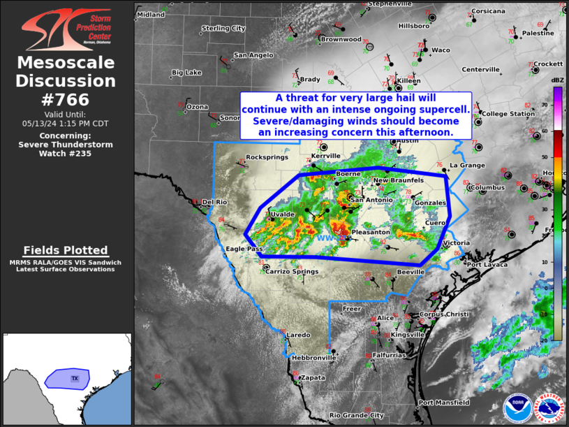
Mesoscale Discussion 0766
NWS Storm Prediction Center Norman OK
1145 AM CDT Mon May 13 2024
Areas affected...Portions of south-central TX
Concerning...Severe Thunderstorm Watch 235...
Valid 131645Z - 131815Z
The severe weather threat for Severe Thunderstorm Watch 235
continues.
SUMMARY...A threat for very large hail will continue with ongoing
supercells. Severe/damaging winds should become an increasing
concern this afternoon as convection attempts to grow upscale into a
bowing cluster.
DISCUSSION...An intense supercell is ongoing to the south of the San
Antonio TX metro as of 1635Z. With extreme instability present
(4000+ J/kg MUCAPE), along with strong deep-layer shear of 45-50 kt,
a supercell mode will likely be maintained in the short term. Steep
mid-level lapse rates noted on area 12Z soundings from DRT/CRP/BRO
will aid robust updraft accelerations and a threat for large to very
large hail, potentially up to 2-3 inches in diameter. To the north
of this supercell into central TX, destructive updraft
interference/interactions have occurred, with a messier storm mode
observed and a lesser threat for large hail. With time, expectations
are for convection to gradually grow upscale into a small bowing
cluster as activity continues eastward through the afternoon. A
greater threat for severe/damaging winds of 60-70 mph should exist
once this mode transition occurs.
..Gleason.. 05/13/2024
https://www.spc.noaa.gov/products/md/md0766.html
0 likes
The above post is NOT an official forecast and should not be used as such. It is just the opinion of the poster and may or may not be backed by sound meteorological data. It is NOT endorsed by any professional institution including Storm2k. For official information, please refer to NWS products.
-
CaptinCrunch

- S2K Supporter
- Posts: 8779
- Age: 58
- Joined: Mon Nov 03, 2003 4:33 pm
- Location: Kennedale, TX (Tarrant Co.)
Re: Texas Spring 2024
Ntxw wrote:Glad our friends in S-C Texas getting rain this morning. That's a hail core south of SA. Should be some more opportunities before climo shifts.
20.44" for the year so far at DFW, normal is 16.59". Most areas east and south of the I-35 corridor are running 25"+. Think the arrow is pointing towards a 1973, 2007, 2020 type La Nina transition from El Nino. Where the prior year was dry and delayed Nino and the La Nina summer was the wet, cool one.
That would be welcomed after last years hot and dry Summer.
0 likes
-
Iceresistance

- Category 5
- Posts: 9586
- Age: 22
- Joined: Sat Oct 10, 2020 9:45 am
- Location: Tecumseh, OK/Norman, OK
Re: Texas Spring 2024
A lot of unexpectedly heavy rain this morning, this picture were from the 3rd storm of the day
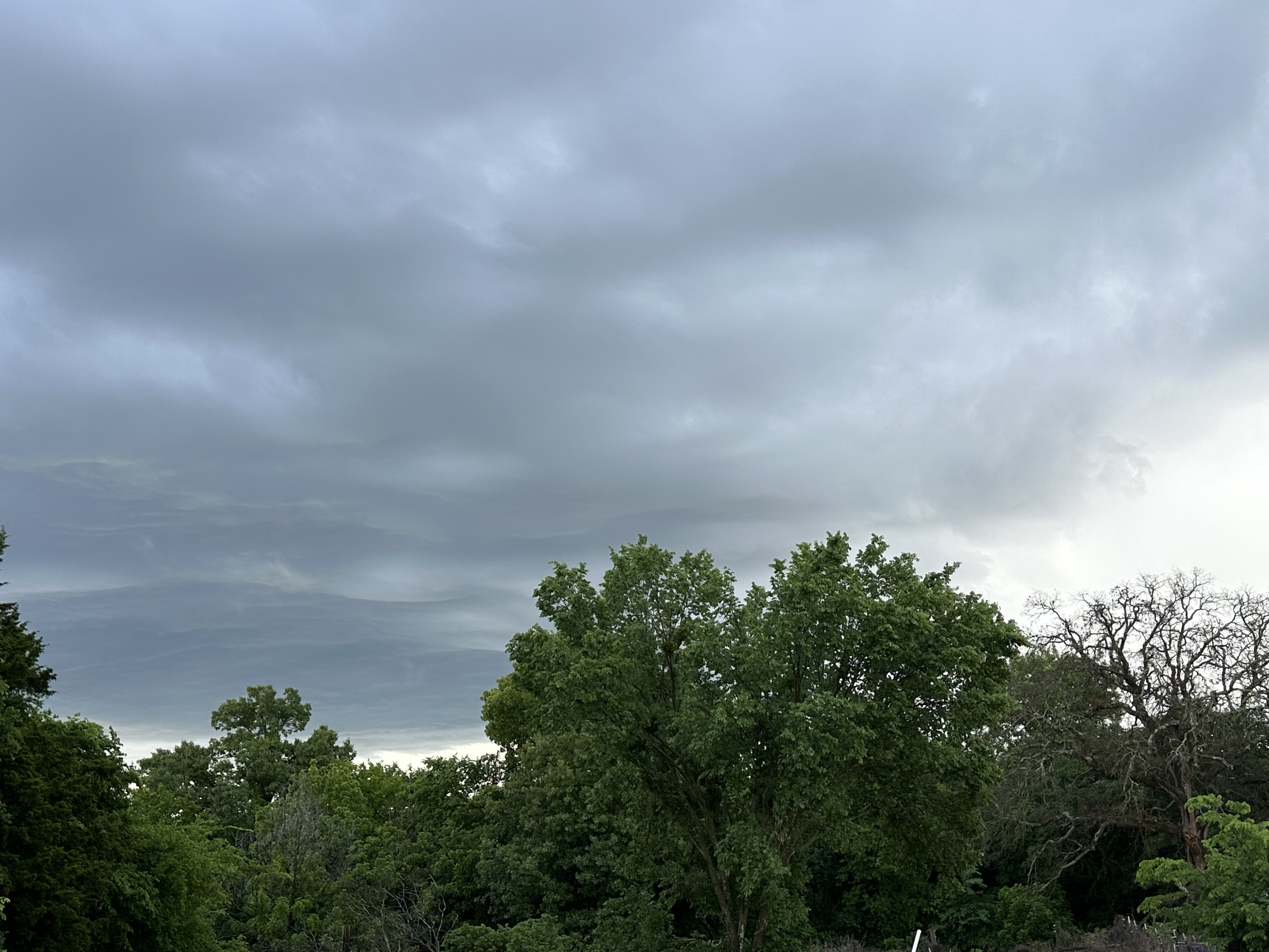
https://s12.gifyu.com/images/SaJFB.jpg
https://s12.gifyu.com/images/SaJFB.jpg
2 likes
Bill 2015 & Beta 2020
Winter 2020-2021
All observations are in Tecumseh, OK unless otherwise noted.
Winter posts are focused mainly for Oklahoma & Texas.
Take any of my forecasts with a grain of salt, refer to the NWS, SPC, and NHC for official information
Never say Never with weather! Because ANYTHING is possible!
Winter 2020-2021
All observations are in Tecumseh, OK unless otherwise noted.
Winter posts are focused mainly for Oklahoma & Texas.
Take any of my forecasts with a grain of salt, refer to the NWS, SPC, and NHC for official information
Never say Never with weather! Because ANYTHING is possible!
Re: Texas Spring 2024
CaptinCrunch wrote:Ntxw wrote:Glad our friends in S-C Texas getting rain this morning. That's a hail core south of SA. Should be some more opportunities before climo shifts.
20.44" for the year so far at DFW, normal is 16.59". Most areas east and south of the I-35 corridor are running 25"+. Think the arrow is pointing towards a 1973, 2007, 2020 type La Nina transition from El Nino. Where the prior year was dry and delayed Nino and the La Nina summer was the wet, cool one.
That would be welcomed after last years hot and dry Summer.
We would still need a wet period at least 1/3rd of the summer season. Doesn't have to be a lot of rain, just enough cloudy and evening popups. Summer its either cooler and wet, or hot and dry.
1 likes
The above post and any post by Ntxw is NOT an official forecast and should not be used as such. It is just the opinion of the poster and may or may not be backed by sound meteorological data. It is NOT endorsed by any professional institution including Storm2k. For official information, please refer to NWS products.
Help support Storm2K!
Help support Storm2K!
-
txtwister78
- Category 5
- Posts: 2187
- Joined: Wed Jan 30, 2019 12:56 pm
- Location: San Antonio
Re: Texas Spring 2024
Biggest rainfall winner so far today stretches from just south of Uvalde to Devine. Radar estimates have anywhere from 2-4 inches of rain across that region. In San Antonio spotty areas of 1-2 inches mainly across western, downtown and eastern sections.
1 likes
-
Edwards Limestone
- S2K Supporter
- Posts: 510
- Age: 36
- Joined: Tue Dec 28, 2021 11:05 am
- Location: Smithson Valley, TX
Re: Texas Spring 2024
txtwister78 wrote:Biggest rainfall winner so far today stretches from just south of Uvalde to Devine. Radar estimates have anywhere from 2-4 inches of rain across that region. In San Antonio spotty areas of 1-2 inches mainly across western, downtown and eastern sections.
Unfortunately I ended up w/ a whopping 0.09" at my place in Comal County. Better than zero though.
Lots of good rain to our south and decent totals near 1" to the northwest in the Guadalupe River watershed.
0 likes
The above post is NOT an official forecast and should not be used as such. It is just the opinion of the poster and may or may not be backed by sound meteorological data. It is NOT endorsed by any professional institution including Storm2k. For official information, please refer to NWS products.

Re: Texas Spring 2024
It's not perfect, but I gotta hand it to the HRRR. It catches on to things and seems to be generally close more often than not.
0 likes
Re: Texas Spring 2024
00z GFS in particular is looking quite torchy for the Southern Plains starting this weekend through the end of May.
Obviously the models will continue to struggle with the exact details over the next several days and potential MCS along the edges will complicate things the further north one is, but with a deeply -PNA and the MJO headed into Phase 4, the signal pattern-wise for that well-advertised Mexican heat ridge to expand/settle NE is definitely there.
And with it in all likelihood being a dirty ridge, it's going to be an oppressively muggy one too (similar to last June).
For the folks down in South/Central Texas, better savor the last of your widespread rain / cloud cover chances this week while you can...
0 likes
-
bubba hotep

- S2K Supporter
- Posts: 6014
- Joined: Wed Dec 28, 2016 1:00 am
- Location: Collin County Texas

Re: Texas Spring 2024
bubba hotep wrote:https://pbs.twimg.com/media/GNhr6_ybEAAC4f9?format=jpg&name=small
Same freaking areas over and over again
1 likes
-
txtwister78
- Category 5
- Posts: 2187
- Joined: Wed Jan 30, 2019 12:56 pm
- Location: San Antonio
Re: Texas Spring 2024
snownado wrote:00z GFS in particular is looking quite torchy for the Southern Plains starting this weekend through the end of May.
Obviously the models will continue to struggle with the exact details over the next several days and potential MCS along the edges will complicate things the further north one is, but with a deeply -PNA and the MJO headed into Phase 4, the signal pattern-wise for that well-advertised Mexican heat ridge to expand/settle NE is definitely there.
And with it in all likelihood being a dirty ridge, it's going to be an oppressively muggy one too (similar to last June).
For the folks down in South/Central Texas, better savor the last of your widespread rain / cloud cover chances this week while you can...
In the words of the legendary college football gameday broadcaster and former coach Lee Corso..."Not so fast my friend".
I think the last 7-10 days of May could bring us one more window of some active weather before we truly get into the doldrums of a dry summer heat pattern down here (tropical impacts notwithstanding). Central and South-Central Texas is no stranger to seeing storms late into May and so I'm not ready to throw in the towel just yet after Thursday partly because we need the rain and climatology is on my side. Lol.
Pattern does still look active though for portions of Texas as it stands today. Hopefully we can rally late.
1 likes
Re: Texas Spring 2024
txtwister78 wrote:snownado wrote:00z GFS in particular is looking quite torchy for the Southern Plains starting this weekend through the end of May.
Obviously the models will continue to struggle with the exact details over the next several days and potential MCS along the edges will complicate things the further north one is, but with a deeply -PNA and the MJO headed into Phase 4, the signal pattern-wise for that well-advertised Mexican heat ridge to expand/settle NE is definitely there.
And with it in all likelihood being a dirty ridge, it's going to be an oppressively muggy one too (similar to last June).
For the folks down in South/Central Texas, better savor the last of your widespread rain / cloud cover chances this week while you can...
In the words of the legendary college football gameday broadcaster and former coach Lee Corso..."Not so fast my friend".
I think the last 7-10 days of May could bring us one more window of some active weather before we truly get into the doldrums of a dry summer heat pattern down here (tropical impacts notwithstanding). Central and South-Central Texas is no stranger to seeing storms late into May and so I'm not ready to throw in the towel just yet after Thursday partly because we need the rain and climatology is on my side. Lol.
Pattern does still look active though for portions of Texas as it stands today. Hopefully we can rally late.
Last year May was wet for me till around the 25th ish and then after that hell set in and I didn’t get any rain for 3 months.
0 likes
Return to “USA & Caribbean Weather”
Who is online
Users browsing this forum: SnowyOwl31 and 45 guests