2024 Global Model Runs Discussion (Out thru day 16)

This is the general tropical discussion area. Anyone can take their shot at predicting a storms path.

Moderator: S2k Moderators

Forum rules

The posts in this forum are NOT official forecasts and should not be used as such. They are just the opinion of the poster and may or may not be backed by sound meteorological data. They are NOT endorsed by any professional institution or STORM2K. For official information, please refer to products from the National Hurricane Center and National Weather Service.

Help Support Storm2K
Message
Author
User avatar
wxman57
Moderator-Pro Met
Moderator-Pro Met
Posts: 22978
Age: 67
Joined: Sat Jun 21, 2003 8:06 pm
Location: Houston, TX (southwest)

Re: 2024 Global Model Runs Discussion (Out thru day 16)

#141 Postby wxman57 » Mon Jun 03, 2024 2:25 pm

StPeteMike wrote:
wxman57 wrote:Looking at today's 12Z GFS, I see a vorticity max over the East Pacific that the GFS takes north into the western Caribbean then off the SE U.S. Coast next Thursday, where it develops into a frontal low. Other models keep all energy in the East Pacific. I'm not inclined to believe the GFS.

The GFS was at least good sniffing out the non-tropical low that developed and went over Hispaniola and now east of Bahamas. Although it did try on earlier runs making it somewhat tropical, but it was still 7 days out showing increased moisture in the Caribbean and impacting Hispaniola.

Point is, I’ll give it some credit and worth in thinking that we could see some increased moisture moving up from Yucatán.West Caribbean and increasing rain chances through south Florida. Will we see a hurricane though? Highly unlikely.


Other models identified the weak, non-tropical low as well. Only the GFS predicted a tropical storm or hurricane.
0 likes   

Stratton23
Category 5
Category 5
Posts: 2519
Joined: Fri Jul 21, 2023 10:59 pm
Location: Katy, Tx

Re: 2024 Global Model Runs Discussion (Out thru day 16)

#142 Postby Stratton23 » Mon Jun 03, 2024 2:39 pm

Regardless of what ever happens with this, im expecting activity to really start picking up after the 13th, wind shear goes below average in the entire caribbean, MJO passage, ensembles definitely show things perking up around that time and beyond, its coming
3 likes   

User avatar
cycloneye
Admin
Admin
Posts: 145295
Age: 68
Joined: Thu Oct 10, 2002 10:54 am
Location: San Juan, Puerto Rico

Re: 2024 Global Model Runs Discussion (Out thru day 16)

#143 Postby cycloneye » Mon Jun 03, 2024 3:17 pm

0 likes   
Visit the Caribbean-Central America Weather Thread where you can find at first post web cams,radars
and observations from Caribbean basin members Click Here

User avatar
cycloneye
Admin
Admin
Posts: 145295
Age: 68
Joined: Thu Oct 10, 2002 10:54 am
Location: San Juan, Puerto Rico

Re: 2024 Global Model Runs Discussion (Out thru day 16)

#144 Postby cycloneye » Mon Jun 03, 2024 3:45 pm

1 likes   
Visit the Caribbean-Central America Weather Thread where you can find at first post web cams,radars
and observations from Caribbean basin members Click Here

User avatar
DorkyMcDorkface
Category 3
Category 3
Posts: 888
Age: 27
Joined: Mon Sep 30, 2019 1:32 pm
Location: Mid-Atlantic

Re: 2024 Global Model Runs Discussion (Out thru day 16)

#145 Postby DorkyMcDorkface » Mon Jun 03, 2024 4:53 pm

1 likes   
Please note the thougths expressed by this account are solely those of the user and are from a hobbyist perspective. For more comprehensive analysis, consult an actual professional meteorologist or meteorology agency.


Floyd 1999 | Isabel 2003 | Hanna 2008 | Irene 2011 | Sandy 2012 | Isaias 2020

Stratton23
Category 5
Category 5
Posts: 2519
Joined: Fri Jul 21, 2023 10:59 pm
Location: Katy, Tx

Re: 2024 Global Model Runs Discussion (Out thru day 16)

#146 Postby Stratton23 » Mon Jun 03, 2024 5:54 pm

Regardless if the GFS ends up being right or wrong, models are in good agreement that the CAG is about to become pretty active, especially once we get past the 13th of june
1 likes   

User avatar
skyline385
Category 5
Category 5
Posts: 2728
Age: 35
Joined: Wed Aug 26, 2020 11:15 pm
Location: Houston TX

Re: 2024 Global Model Runs Discussion (Out thru day 16)

#147 Postby skyline385 » Mon Jun 03, 2024 6:38 pm

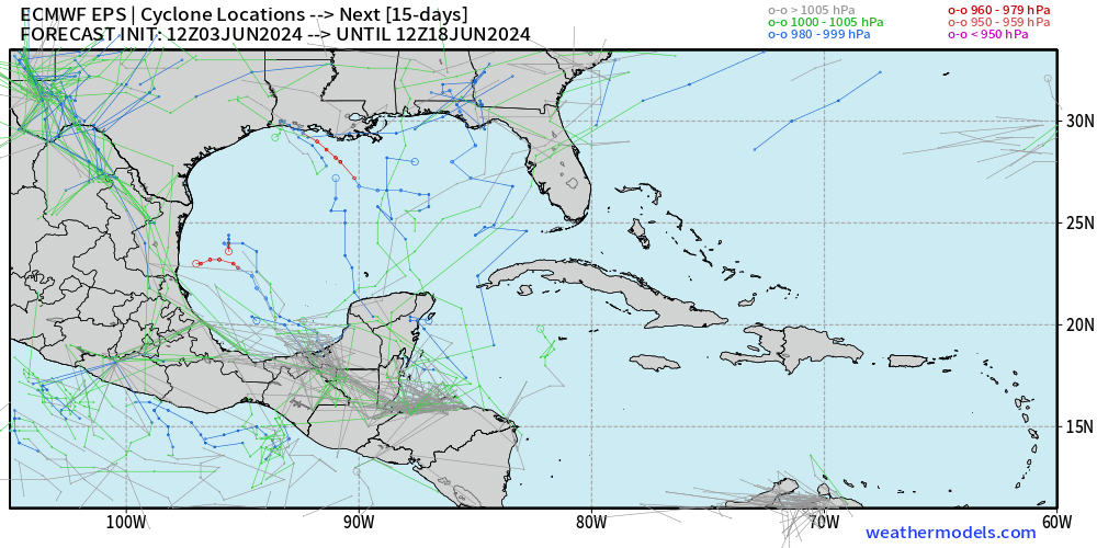
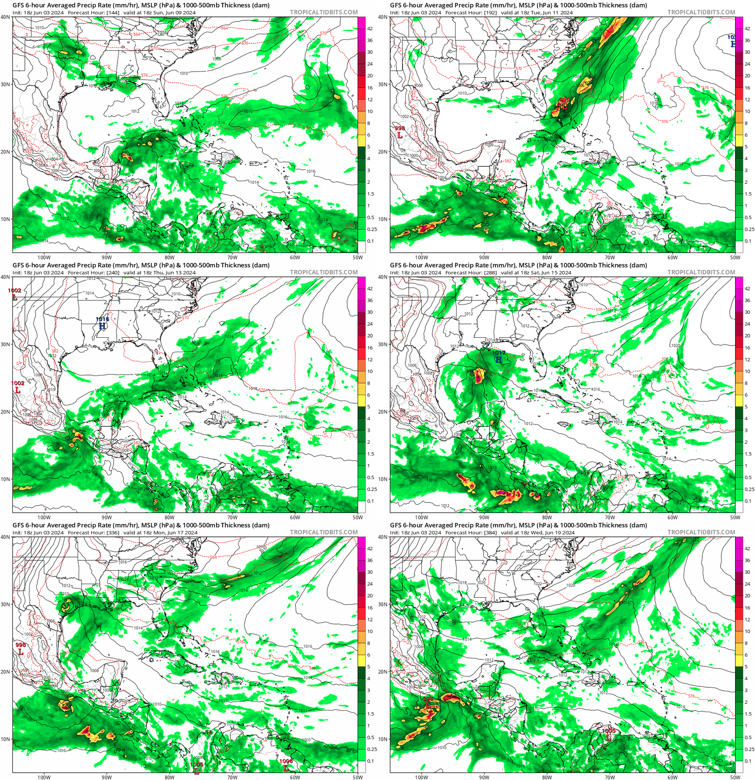
Not that I take the GFS past 120 hours seriously but it is interesting that it has systems in similar locations to the EPS. Regardless of something forming or not, the NATL seems like its ready to go with activity gradually increasing on all models.

Image

Image
2 likes   

User avatar
kevin
Category 5
Category 5
Posts: 2586
Age: 26
Joined: Wed Aug 28, 2019 4:35 am

Re: 2024 Global Model Runs Discussion (Out thru day 16)

#148 Postby kevin » Tue Jun 04, 2024 5:21 am

06z GFS shows a TS near Florida on June 11/12 forming from the disturbance crossing over from the Pacific on June 9/10.

Edit: deepens to 992 mb as it moves away from Florida.

Image
0 likes   

User avatar
kevin
Category 5
Category 5
Posts: 2586
Age: 26
Joined: Wed Aug 28, 2019 4:35 am

Re: 2024 Global Model Runs Discussion (Out thru day 16)

#149 Postby kevin » Tue Jun 04, 2024 8:28 am

00z GEM/CMC also showed this disturbance as a TD/TS as it passes over Florida.

Image

Image
0 likes   

User avatar
N2FSU
S2K Supporter
S2K Supporter
Posts: 1062
Joined: Thu Sep 04, 2003 2:04 pm
Location: Tallahassee, FL

Re: 2024 Global Model Runs Discussion (Out thru day 16)

#150 Postby N2FSU » Tue Jun 04, 2024 12:16 pm

12z GFS for next Thursday night
Image


Sent from my iPad using Tapatalk
4 likes   

User avatar
StPeteMike
Category 2
Category 2
Posts: 631
Joined: Thu Jun 07, 2018 11:26 pm

Re: 2024 Global Model Runs Discussion (Out thru day 16)

#151 Postby StPeteMike » Tue Jun 04, 2024 12:17 pm

12z has a strong TS going into the Big Bend area, though most of the precipitation is right heavy and helps the Peninsula with its drought a little. But that’s not all, it has another TS about 7 days out impacting almost identical location :lol:

Image
2 likes   
The above post is not official and should not be used as such. It is the opinion of the poster and may or may not be backed by sound meteorological data. It is not endorsed by any professional institution or storm2k.org. For official information, please refer to the NHC and NWS products.

User avatar
N2FSU
S2K Supporter
S2K Supporter
Posts: 1062
Joined: Thu Sep 04, 2003 2:04 pm
Location: Tallahassee, FL

Re: 2024 Global Model Runs Discussion (Out thru day 16)

#152 Postby N2FSU » Tue Jun 04, 2024 12:20 pm

Image
lala land


Sent from my iPad using Tapatalk
1 likes   

User avatar
wxman57
Moderator-Pro Met
Moderator-Pro Met
Posts: 22978
Age: 67
Joined: Sat Jun 21, 2003 8:06 pm
Location: Houston, TX (southwest)

Re: 2024 Global Model Runs Discussion (Out thru day 16)

#153 Postby wxman57 » Tue Jun 04, 2024 2:23 pm

12Z GFS remains all alone in its prediction of a hurricane in the Gulf next week. Nothing significant in the EC, ICON, or CMC. Don't believe it. It may have the general idea of increasing moisture, but that's as far as I'd believe.
6 likes   

User avatar
DorkyMcDorkface
Category 3
Category 3
Posts: 888
Age: 27
Joined: Mon Sep 30, 2019 1:32 pm
Location: Mid-Atlantic

Re: 2024 Global Model Runs Discussion (Out thru day 16)

#154 Postby DorkyMcDorkface » Tue Jun 04, 2024 3:14 pm

wxman57 wrote:12Z GFS remains all alone in its prediction of a hurricane in the Gulf next week. Nothing significant in the EC, ICON, or CMC. Don't believe it. It may have the general idea of increasing moisture, but that's as far as I'd believe.

I still think it is reasonable to anticipate some form of TCG in the Caribbean/Gulf soon. The MJO should be in an optimal phase by next week, and that could very well provide a window for potential development. The GFS isn't the most reliable model around this time of year given its known biases, but given the situation it wouldn't surprise me at all to see some of the other guidance follow suit. As someone highlighted earlier, last night's 00z CMC run actually had development, although the 12z appears to have dropped it.
6 likes   

Please note the thougths expressed by this account are solely those of the user and are from a hobbyist perspective. For more comprehensive analysis, consult an actual professional meteorologist or meteorology agency.


Floyd 1999 | Isabel 2003 | Hanna 2008 | Irene 2011 | Sandy 2012 | Isaias 2020

User avatar
HurricaneBelle
S2K Supporter
S2K Supporter
Posts: 1179
Joined: Sun Aug 27, 2006 6:12 pm
Location: Clearwater, FL

Re: 2024 Global Model Runs Discussion (Out thru day 16)

#155 Postby HurricaneBelle » Tue Jun 04, 2024 4:13 pm

the GFS truck is down my block, I should have the new model run soon Image
14 likes   

jlauderdal
S2K Supporter
S2K Supporter
Posts: 7182
Joined: Wed May 19, 2004 5:46 am
Location: NE Fort Lauderdale
Contact:

Re: RE: Re: 2024 Global Model Runs Discussion (Out thru day 16)

#156 Postby jlauderdal » Tue Jun 04, 2024 4:51 pm

HurricaneBelle wrote:the GFS truck is down my block, I should have the new model run soon https://i.ytimg.com/vi/t5Yynd2qN1I/maxresdefault.jpg
That is avatar material with a 384h underneath
2 likes   

Stratton23
Category 5
Category 5
Posts: 2519
Joined: Fri Jul 21, 2023 10:59 pm
Location: Katy, Tx

Re: 2024 Global Model Runs Discussion (Out thru day 16)

#157 Postby Stratton23 » Tue Jun 04, 2024 5:46 pm

18z GFS shifted west by a decent margin, still likes the idea of this thing developing, also looks like the 500 mb height pattern is different on this run, allowing for a “ landfall” if you will, more towards pensacola, florida, wouldn’t be shocked to see guidance start to follow the GFS, NOAA has even acknowledged the GFS, by highlighting a hatched zone of potential tropical development in their global outlook, so it cant be dismissed entirely
2 likes   

User avatar
skyline385
Category 5
Category 5
Posts: 2728
Age: 35
Joined: Wed Aug 26, 2020 11:15 pm
Location: Houston TX

Re: 2024 Global Model Runs Discussion (Out thru day 16)

#158 Postby skyline385 » Tue Jun 04, 2024 7:29 pm

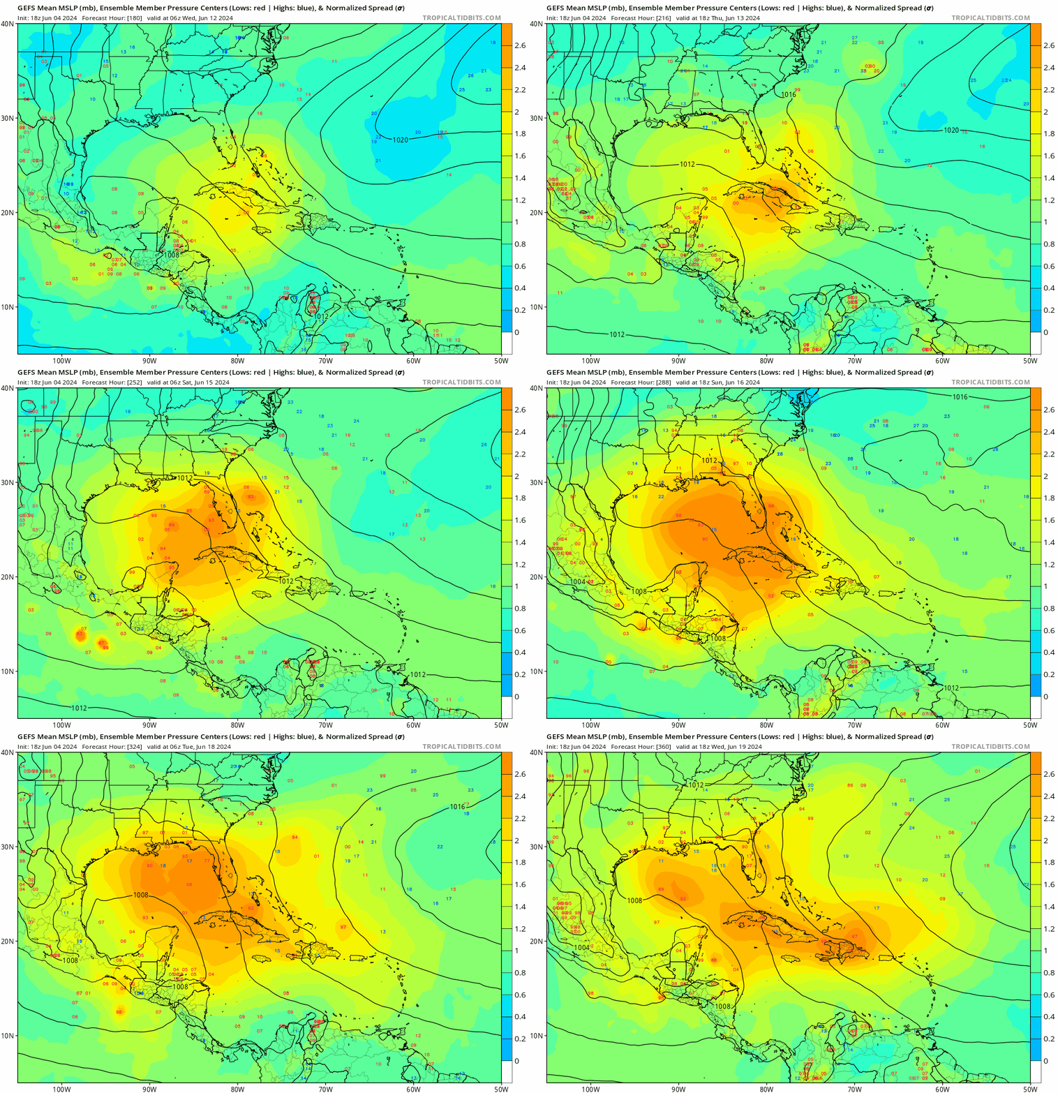
GEFS just gave up, all over the place would be an understatement

Image
3 likes   

jlauderdal
S2K Supporter
S2K Supporter
Posts: 7182
Joined: Wed May 19, 2004 5:46 am
Location: NE Fort Lauderdale
Contact:

Re: RE: Re: 2024 Global Model Runs Discussion (Out thru day 16)

#159 Postby jlauderdal » Tue Jun 04, 2024 7:58 pm

skyline385 wrote:GEFS just gave up, all over the place would be an understatement

https://i.postimg.cc/wjDR6Y8Q/gfs-ememb-lowlocs-watl-fh180-360.gif
Typical early season slopfest
1 likes   

Stratton23
Category 5
Category 5
Posts: 2519
Joined: Fri Jul 21, 2023 10:59 pm
Location: Katy, Tx

Re: 2024 Global Model Runs Discussion (Out thru day 16)

#160 Postby Stratton23 » Tue Jun 04, 2024 8:02 pm

Because this is of a CAG origin, it is going to be a sloppy system, but thats also why you see ensemble members all over the place, where does a low pressure try to form? The western caribbean/ yucatan channel or the bay of campache?
1 likes   


Return to “Talkin' Tropics”

Who is online

Users browsing this forum: gib, Hurricane2022, HurricaneFan, RomP and 49 guests