LarryWx wrote:SFLcane wrote:Deshaunrob17 wrote:That wave in the Eastern Looks very impressive. Some EPS members try to briefly spin it up the day for so, but probably won’t amount to much until it reaches the Western Caribbean/ Gulf late next week.
Things are starting to look more interesting. Very soon (like the end of this month) I won’t be surprised if start looking out in the MDR for development. July is a month to watch. Models show shear really subsiding , so only Sharan Dust May keep the cap on.
https://x.com/AdrianLinares28/status/1800875023223382043
Adrian,
We'll see. June of both 2022 and 2023 had unusually well developed waves coming off of Africa. As a result a good number of S2K posts in June of those two years were similar. But for both years there was about a 2 month long period afterward for which no emerging from Africa AEW later lead to a TCG:
1)
2022:
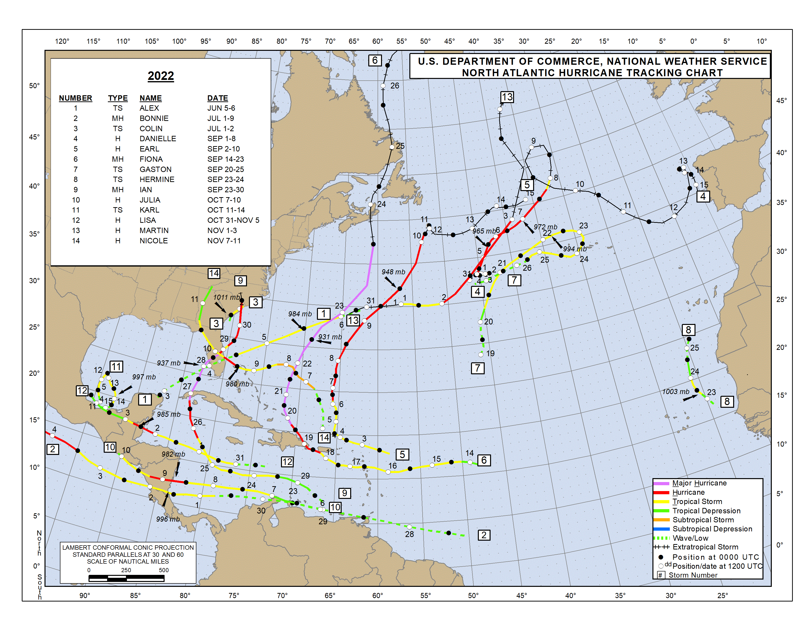
https://www.nhc.noaa.gov/data/tracks/tracks-at-2022.png 2022 had two well developed AEWs in mid to late June. The one that came off Africa on June 22nd later had a TCG (Bonnie).
It then became absolutely dead quiet in the MDR due to dry wave after dry wave. It was over 2 months before the next AEW emerged from Africa that lead to an MDR TCG! On Aug 25th, a disorganized AEW came off of Africa. Convection didn't increase until Sep 1st, which then lead to Earl.
https://en.wikipedia.org/wiki/2022_Atla ... ane_season2)
2023:
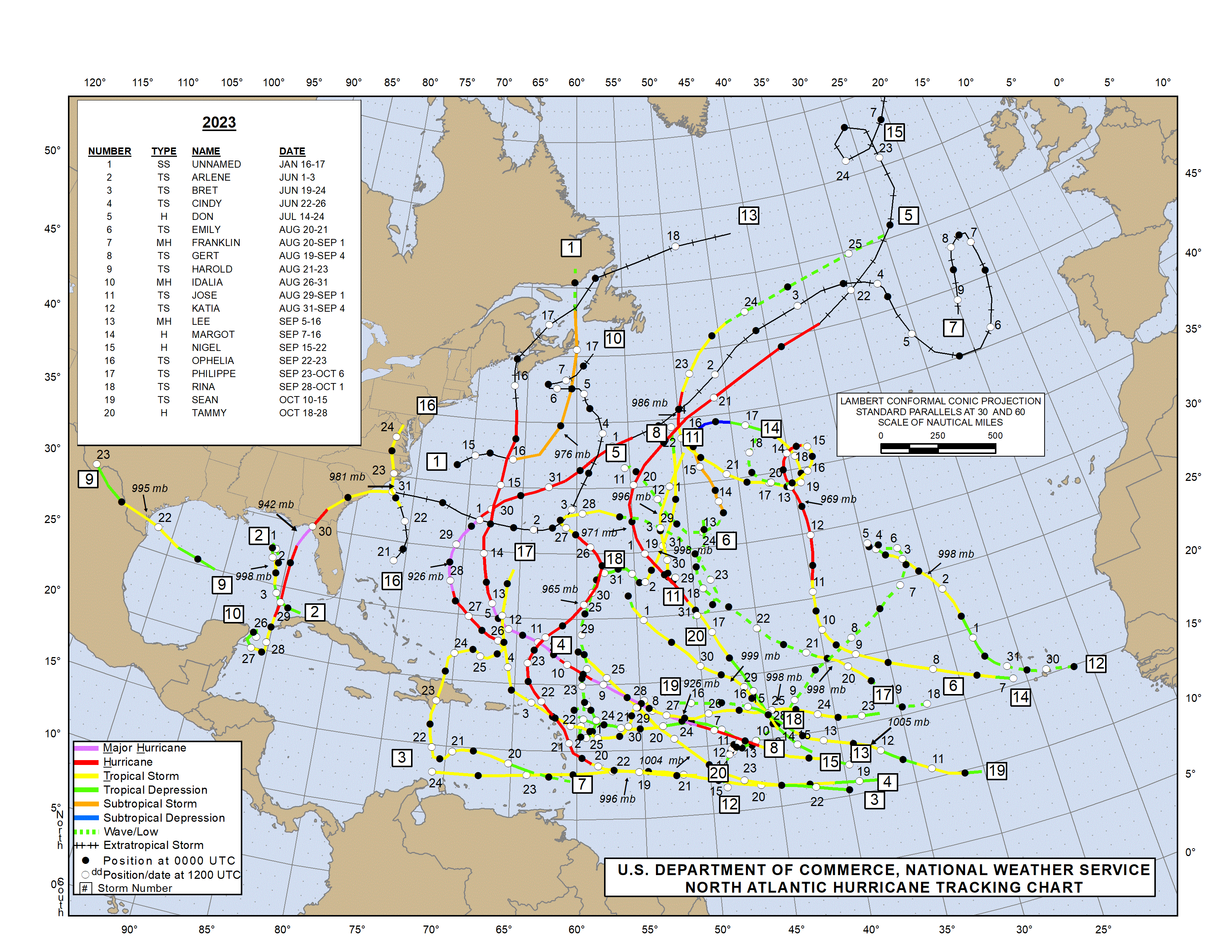
https://www.nhc.noaa.gov/data/tracks/tracks-at-2023.png 2023 had two TS's form in the MDR!
- On June 15th, an AEW came off Africa that lead to Bret on June 19th.
- On June 18th, an AEW came off Africa that lead to Cindy on June 22nd.
-
It took til Aug 13th for the next AEW to emerge from Africa that later produced an MDR TCG. That one became TD 6 on Aug 19th and later became Gert.
https://simple.wikipedia.org/wiki/2023_ ... ane_season So, IF 2024 were to turn out similar to 2022 and 2023, the MDR may go quiet for quite awhile after an initially unusually active period in June.
Opinions on this?
Here's a thought. Outside of the obvious (approx) 2 month gap between significant EAW's that occurred in 2022 & 2023, there were respectively 3 & 4 named storms that did form for those years. Those TC's were largely less noteworthy either as a result of sub-tropic genesis and/or storm track, or for some given their weaker presentation due to some inhibiting conditions. Even if a similar gap occurs with particularly strong EAW's during 2024, I think it may be reasonable to think that a number of increasingly threatening factors during 2024 and at this time might-
1) enhance the number of TC's that do form within that 2 month period of time from 3 to 4 named storms, to possibly 5 or more.
2) cause those TS's that do form within this time span, to be stronger given the warmer SST's AND primary genesis primarily occurring in the deeper tropics (lower latitudes)
3) result in a greater landfall risk as a result of anticipated further west genesis and storm tracks.
Furthermore, it goes without saying that all of the above doesn't even begin to consider whether that approx 2 month gap in significantly strong AEW's occurred in '22 & '23 as a result of SAL, higher E. Atlantic surface pressures causing a suppression of the ITCZ, deficiancy in low to mid level humidity, vertical shear, etc..... or whether those same mitigating conditions will similarly occur and impact 2024 early season EAW's.


