Low pressure to organize over the Southwestern Gulf of Mexico (Is INVEST 91L)

This is the general tropical discussion area. Anyone can take their shot at predicting a storms path.

Moderator: S2k Moderators

Forum rules

The posts in this forum are NOT official forecasts and should not be used as such. They are just the opinion of the poster and may or may not be backed by sound meteorological data. They are NOT endorsed by any professional institution or STORM2K. For official information, please refer to products from the National Hurricane Center and National Weather Service.

Help Support Storm2K
Message
Author
User avatar
kevin
Category 5
Category 5
Posts: 2554
Age: 26
Joined: Wed Aug 28, 2019 4:35 am

Low pressure to organize over the Southwestern Gulf of Mexico (Is INVEST 91L)

#1 Postby kevin » Wed Jun 12, 2024 6:53 am

We had to wait a bit, but it looks like it's really starting now. Another lemon.

Image

2. Southwestern Gulf of Mexico:
A broad area of low pressure could form over the weekend across the
southwestern Gulf of Mexico. Environmental conditions appear
conducive for some slow development early next week while the
system moves slowly westward or west-northwestward.
* Formation chance through 48 hours...low...near 0 percent.
* Formation chance through 7 days...low...20 percent.
1 likes   

User avatar
chaser1
S2K Supporter
S2K Supporter
Posts: 5406
Age: 64
Joined: Sat Oct 15, 2005 5:59 pm
Location: Longwood, Fl

Re: Disturbance forecast to develop in the Southwestern Gulf of Mexico (0/20)

#2 Postby chaser1 » Wed Jun 12, 2024 7:05 am

A bump-up to 30%-40% by this evening wouldn't surprise me.
0 likes   
Andy D

(For official information, please refer to the NHC and NWS products.)

User avatar
REDHurricane
Category 1
Category 1
Posts: 394
Age: 27
Joined: Sun Jul 03, 2022 2:36 pm
Location: Northeast Pacific Ocean

Re: Disturbance forecast to develop in the Southwestern Gulf of Mexico (0/20)

#3 Postby REDHurricane » Wed Jun 12, 2024 7:09 am

Lucky that the center of circulation for this system appears like it'll be stuck over land for the majority of its existence, or else we might be seeing a strong hurricane form instead of what will likely be a strong TS at most
0 likes   

zzzh
Category 3
Category 3
Posts: 833
Joined: Thu Sep 02, 2021 1:13 pm

Re: Disturbance forecast to develop in the Southwestern Gulf of Mexico

#4 Postby zzzh » Wed Jun 12, 2024 7:29 am

Some models think the system will form from the monsoon trough in SW Caribbean, others have a crossover from EPAC.
0 likes   

User avatar
kevin
Category 5
Category 5
Posts: 2554
Age: 26
Joined: Wed Aug 28, 2019 4:35 am

Re: Disturbance forecast to develop in the Southwestern Gulf of Mexico (0/20)

#5 Postby kevin » Wed Jun 12, 2024 7:33 am

Model runs for this system.

06z GFS = 996 mb TS, Mexico landfall, +168 hours

00z ICON = 996 mb TS, Mexico landfall, +180 hours
00z ECMWF = 994 mb TS, Mexico landfall, +180 hours
00z ECMWF-AIFS = 1000 mb TS/TD, Texas landfall, +198 hours
00z CMC = 994 mb TS, Mexico landfall, +192 hours
0 likes   

User avatar
skyline385
Category 5
Category 5
Posts: 2728
Age: 34
Joined: Wed Aug 26, 2020 11:15 pm
Location: Houston TX

Re: Disturbance forecast to develop in the Southwestern Gulf of Mexico (0/20)

#6 Postby skyline385 » Wed Jun 12, 2024 8:07 am

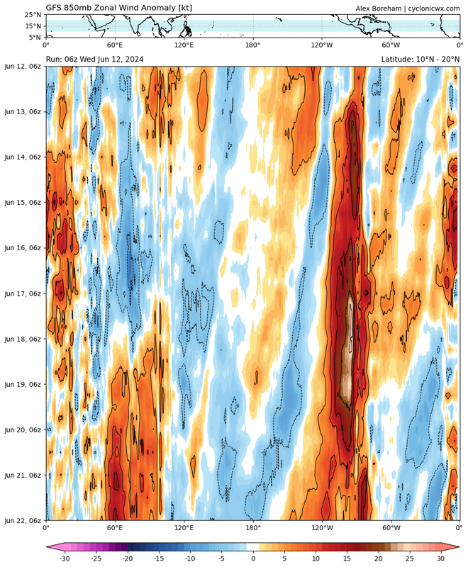
zzzh wrote:Some models think the system will form from the monsoon trough in SW Caribbean, others have a crossover from EPAC.


It looks to be a WWB responsible for it.

Image
0 likes   

User avatar
wxman57
Moderator-Pro Met
Moderator-Pro Met
Posts: 22950
Age: 67
Joined: Sat Jun 21, 2003 8:06 pm
Location: Houston, TX (southwest)

Re: Disturbance forecast to develop in the Southwestern Gulf of Mexico (0/20)

#7 Postby wxman57 » Wed Jun 12, 2024 8:28 am

With all four globals (GFS, EC, CMC, ICON) in good agreement for a BoC system next Tue/Wed, I think chances are up quite a bit (maybe 70-80%). Good news is that it won't last long and should move inland into Mexico by late Wednesday. A "shortie" to start the year.
6 likes   

Stratton23
Category 5
Category 5
Posts: 2370
Joined: Fri Jul 21, 2023 10:59 pm
Location: Katy, Tx

Re: Disturbance forecast to develop in the Southwestern Gulf of Mexico (0/20)

#8 Postby Stratton23 » Wed Jun 12, 2024 8:35 am

Even if it goes into mexico that moisture feed is getting funneled right into the Texas coast, if anything we dont want the low to consolidate as that would pull moisture away from us, ill gladly take heavy rain
0 likes   

User avatar
ATXAG95
Tropical Low
Tropical Low
Posts: 16
Joined: Thu Feb 11, 2021 10:45 am

Re: Disturbance forecast to develop in the Southwestern Gulf of Mexico (0/20)

#9 Postby ATXAG95 » Wed Jun 12, 2024 8:42 am

This thing needs to hit the border and run up the Rio Grande to replenish Falcon and Amistad.
2 likes   

User avatar
wxman57
Moderator-Pro Met
Moderator-Pro Met
Posts: 22950
Age: 67
Joined: Sat Jun 21, 2003 8:06 pm
Location: Houston, TX (southwest)

Re: Disturbance forecast to develop in the Southwestern Gulf of Mexico (0/20)

#10 Postby wxman57 » Wed Jun 12, 2024 11:29 am

12Z GFS is farther south, inland south of Tampico Tuesday night. This system has a much better shot at briefly becoming a TS than 90L. I'd say maybe as high as 70-80%. Just enhanced rain for Texas. South Texas could use the rain.
0 likes   

Stratton23
Category 5
Category 5
Posts: 2370
Joined: Fri Jul 21, 2023 10:59 pm
Location: Katy, Tx

Re: Disturbance forecast to develop in the Southwestern Gulf of Mexico (0/20)

#11 Postby Stratton23 » Wed Jun 12, 2024 11:46 am

12z GEFS has more members showing development on the east side of the yucatan, different than its operational run, that can change the track by a good deal
0 likes   

User avatar
cycloneye
Admin
Admin
Posts: 143862
Age: 68
Joined: Thu Oct 10, 2002 10:54 am
Location: San Juan, Puerto Rico

Re: Disturbance forecast to develop in the Southwestern Gulf of Mexico (0/20)

#12 Postby cycloneye » Wed Jun 12, 2024 12:27 pm

GEFS ensembles.

Image
0 likes   
Visit the Caribbean-Central America Weather Thread where you can find at first post web cams,radars
and observations from Caribbean basin members Click Here

User avatar
cycloneye
Admin
Admin
Posts: 143862
Age: 68
Joined: Thu Oct 10, 2002 10:54 am
Location: San Juan, Puerto Rico

Re: Disturbance forecast to develop in the Southwestern Gulf of Mexico (0/30)

#13 Postby cycloneye » Wed Jun 12, 2024 12:28 pm

Up to 30%.

Southwestern Gulf of Mexico:
A broad area of low pressure could form over the weekend across the
southwestern Gulf of Mexico. Environmental conditions appear
conducive for some slow development early next week while the
system moves slowly westward or west-northwestward.
* Formation chance through 48 hours...low...near 0 percent.
* Formation chance through 7 days...low...30 percent.
0 likes   
Visit the Caribbean-Central America Weather Thread where you can find at first post web cams,radars
and observations from Caribbean basin members Click Here

bohai
Tropical Depression
Tropical Depression
Posts: 76
Age: 65
Joined: Tue Jun 02, 2020 12:57 pm
Location: Comfort, TX

Re: Disturbance forecast to develop in the Southwestern Gulf of Mexico (0/30)

#14 Postby bohai » Wed Jun 12, 2024 12:28 pm

We are desperate in south and s central Texas. One of our lakes is, Medina, is down to 2% of the normal level. We are about 50 mi NW of San Antonio, and the aquifer (subterranean) that we get our water from is at stage 4. So a dumping of rain would be extremely beneficial as long as it is not Harvey level rains.
1 likes   

Bobbyh83
Tropical Wave
Tropical Wave
Posts: 3
Joined: Tue Jan 15, 2019 7:51 pm

Re: Disturbance forecast to develop in the Southwestern Gulf of Mexico (0/30)

#15 Postby Bobbyh83 » Wed Jun 12, 2024 12:31 pm

bohai wrote:We are desperate in south and s central Texas. One of our lakes is, Medina, is down to 2% of the normal level. We are about 50 mi NW of San Antonio, and the aquifer (subterranean) that we get our water from is at stage 4. So a dumping of rain would be extremely beneficial as long as it is not Harvey level rains.


Such a crazy gradient across the state. Trinity River has been above flood stage since April 28th I believe.
0 likes   

User avatar
Category5Kaiju
Category 5
Category 5
Posts: 4051
Joined: Thu Dec 24, 2020 12:45 pm
Location: Seattle

Re: Disturbance forecast to develop in the Southwestern Gulf of Mexico (0/30)

#16 Postby Category5Kaiju » Wed Jun 12, 2024 12:36 pm

Interesting historic tidbit: During 2010, which is oftentimes compared with this year, this happened in June.

Image
0 likes   
Unless explicitly stated, all info in my posts is based on my own opinions and observations. Tropical storms and hurricanes can be extremely dangerous. Do not think you can beat Mother Nature. Refer to an accredited weather research agency or meteorologist if you need to make serious decisions regarding an approaching storm.

Astromanía
Category 2
Category 2
Posts: 767
Age: 26
Joined: Sat Aug 25, 2018 10:34 pm
Location: Monterrey, N.L, México

Re: Disturbance forecast to develop in the Southwestern Gulf of Mexico (0/30)

#17 Postby Astromanía » Wed Jun 12, 2024 12:37 pm

I hope this gives lot of rain to northeast Mexico, we are in a constantly drougth, dams are in a extremely low levels, people are losing water service in many areas and the heat waves are not helping
1 likes   

Astromanía
Category 2
Category 2
Posts: 767
Age: 26
Joined: Sat Aug 25, 2018 10:34 pm
Location: Monterrey, N.L, México

Re: Disturbance forecast to develop in the Southwestern Gulf of Mexico (0/30)

#18 Postby Astromanía » Wed Jun 12, 2024 12:40 pm

Category5Kaiju wrote:Interesting historic tidbit: During 2010, which is oftentimes compared with this year, this happened in June.

https://upload.wikimedia.org/wikipedia/commons/2/25/Alex_2010-07-01_0202Z.png

Oh my beloved Alex, the worst natural disaster in monterrey history breaking rain records in the region, many people lost but the dams were full for a whole decade
2 likes   

User avatar
storm_in_a_teacup
Category 1
Category 1
Posts: 416
Joined: Wed Aug 16, 2017 5:01 pm
Location: Huntsville, Alabama (originally from Houston)
Contact:

Re: Disturbance forecast to develop in the Southwestern Gulf of Mexico (0/30)

#19 Postby storm_in_a_teacup » Wed Jun 12, 2024 12:43 pm

Does anyone know where the term 'lemon' for the yellow blobs on the map originate? It's cute but I'm curious.
1 likes   
I know I can't straddle the atmosphere...just a tiny storm in your teacup, girl.

User avatar
Category5Kaiju
Category 5
Category 5
Posts: 4051
Joined: Thu Dec 24, 2020 12:45 pm
Location: Seattle

Re: Disturbance forecast to develop in the Southwestern Gulf of Mexico (0/30)

#20 Postby Category5Kaiju » Wed Jun 12, 2024 1:05 pm

storm_in_a_teacup wrote:Does anyone know where the term 'lemon' for the yellow blobs on the map originate? It's cute but I'm curious.


I think it originated just based on the color. Hence orange for moderate and cherry for high development odds (though considering quite a few species of cherry are black or even yellow, I’d personally call high development odds strawberry) :lol:
1 likes   
Unless explicitly stated, all info in my posts is based on my own opinions and observations. Tropical storms and hurricanes can be extremely dangerous. Do not think you can beat Mother Nature. Refer to an accredited weather research agency or meteorologist if you need to make serious decisions regarding an approaching storm.


Return to “Talkin' Tropics”

Who is online

Users browsing this forum: Google Adsense [Bot], sasha_B and 75 guests