2024 Indicators: SST's, MSLP, Shear, SAL, Steering, Instability (Day 16+ Climate Models)

This is the general tropical discussion area. Anyone can take their shot at predicting a storms path.

Moderator: S2k Moderators

Forum rules

The posts in this forum are NOT official forecasts and should not be used as such. They are just the opinion of the poster and may or may not be backed by sound meteorological data. They are NOT endorsed by any professional institution or STORM2K. For official information, please refer to products from the National Hurricane Center and National Weather Service.

Help Support Storm2K
Message
Author
zzzh
Category 3
Category 3
Posts: 834
Joined: Thu Sep 02, 2021 1:13 pm

Re: 2024 Indicators: SST's, MSLP, Shear, SAL, Steering, Instability (Day 16+ Climate Models)

#1241 Postby zzzh » Thu Jun 13, 2024 6:34 am

zzzh wrote:You can always find some convectively active waves off the coast of Africa. This is very common for June, especially when you don't consider the duration. If it stays convectively active for 3 days then I would call it impressive.

As expected, the convection of that wave completely collapsed in just a day. People here are not very familiar with June wave climatology.
0 likes   

tolakram
Admin
Admin
Posts: 20009
Age: 62
Joined: Sun Aug 27, 2006 8:23 pm
Location: Florence, KY (name is Mark)

Re: 2024 Indicators: SST's, MSLP, Shear, SAL, Steering, Instability (Day 16+ Climate Models)

#1242 Postby tolakram » Thu Jun 13, 2024 6:55 am

zzzh wrote:
zzzh wrote:You can always find some convectively active waves off the coast of Africa. This is very common for June, especially when you don't consider the duration. If it stays convectively active for 3 days then I would call it impressive.

As expected, the convection of that wave completely collapsed in just a day. People here are not very familiar with June wave climatology.


This type of post in needlessly inflammatory and since there's a few of you who seems to take advantage of our quiet moderation policy I will call you out here.

Give opinions about the season and your thoughts about it, not about what you think of other posters. No exceptions!
8 likes   
M a r k
- - - - -
Join us in chat: Storm2K Chatroom Invite. Android and IOS apps also available.

The posts in this forum are NOT official forecasts and should not be used as such. Posts are NOT endorsed by any professional institution or STORM2K.org. For official information and forecasts, please refer to NHC and NWS products.

User avatar
cycloneye
Admin
Admin
Posts: 145323
Age: 68
Joined: Thu Oct 10, 2002 10:54 am
Location: San Juan, Puerto Rico

Re: 2024 Indicators: SST's, MSLP, Shear, SAL, Steering, Instability (Day 16+ Climate Models)

#1243 Postby cycloneye » Thu Jun 13, 2024 8:41 am

0 likes   
Visit the Caribbean-Central America Weather Thread where you can find at first post web cams,radars
and observations from Caribbean basin members Click Here

User avatar
aspen
Category 5
Category 5
Posts: 8818
Joined: Sat Oct 12, 2019 7:10 pm
Location: Connecticut, USA

Re: 2024 Indicators: SST's, MSLP, Shear, SAL, Steering, Instability (Day 16+ Climate Models)

#1244 Postby aspen » Thu Jun 13, 2024 10:12 am

Teban54 wrote:
ScottNAtlanta wrote:
LarryWx wrote:
Scott,
Thanks for your reply.
1) Was there dry mid level air dominating during those active periods of June of 2022 and 2023?
2) The precursor AEWs to Bonnie of 2022 and Bret/Cindy of 2023 also held convection after emerging from Africa.

As I recall...Bonnie struggled the entire time it moved over the Atlantic and really didn't get going until it was about to cross over to the Pacific. I'm pretty sure with Bonnie it was dry air. Thunderstorms would build only to collapse.

Dry air wasn't the culprit for Bonnie. The main reason was that it was moving so fast (typical for June) that it couldn't close off a circulation.

That, and it was at quite a lot latitude and ran into the northernmost coast of South America, preventing it from ever developing until it reached the SW Car. Had it gone a little further north like the aggressive Euro runs said it would, it likely would’ve developed far sooner.
0 likes   
Irene '11 Sandy '12 Hermine '16 5/15/2018 Derecho Fay '20 Isaias '20 Elsa '21 Henri '21 Ida '21

I am only a meteorology enthusiast who knows a decent amount about tropical cyclones. Look to the professional mets, the NHC, or your local weather office for the best information.

User avatar
cycloneye
Admin
Admin
Posts: 145323
Age: 68
Joined: Thu Oct 10, 2002 10:54 am
Location: San Juan, Puerto Rico

Re: 2024 Indicators: SST's, MSLP, Shear, SAL, Steering, Instability (Day 16+ Climate Models)

#1245 Postby cycloneye » Thu Jun 13, 2024 10:46 am

0 likes   
Visit the Caribbean-Central America Weather Thread where you can find at first post web cams,radars
and observations from Caribbean basin members Click Here

IsabelaWeather
Category 1
Category 1
Posts: 287
Age: 35
Joined: Tue Jul 07, 2020 7:29 am
Location: Isabela, Puerto Rico

Re: 2024 Indicators: SST's, MSLP, Shear, SAL, Steering, Instability (Day 16+ Climate Models)

#1246 Postby IsabelaWeather » Thu Jun 13, 2024 1:54 pm

A little OT, but there is a small area of circulation moving SW just NE of PR. I am just curious what it is and if it could make "landfall" in PR. Its probably too weak to survive the trip though. Just thought it was cool on satellite.
0 likes   

Deshaunrob17
Tropical Storm
Tropical Storm
Posts: 207
Joined: Tue Aug 18, 2020 7:49 am

Re: 2024 Indicators: SST's, MSLP, Shear, SAL, Steering, Instability (Day 16+ Climate Models)

#1247 Postby Deshaunrob17 » Thu Jun 13, 2024 7:15 pm

This week is Florida; next week is Texas and Mexico - extreme rains. We’re in for a long summer with these very warm SSTs …… It’s funny that story was different a couple of weeks ago- these places were dealing heatwaves and drought- again aided by the warm SSTs.
Let’s not forget why is happening across the pond in Spain, France and Germany
0 likes   

User avatar
chaser1
S2K Supporter
S2K Supporter
Posts: 5464
Age: 64
Joined: Sat Oct 15, 2005 5:59 pm
Location: Longwood, Fl

Re: 2024 Indicators: SST's, MSLP, Shear, SAL, Steering, Instability (Day 16+ Climate Models)

#1248 Postby chaser1 » Thu Jun 13, 2024 9:58 pm

IsabelaWeather wrote:A little OT, but there is a small area of circulation moving SW just NE of PR. I am just curious what it is and if it could make "landfall" in PR. Its probably too weak to survive the trip though. Just thought it was cool on satellite.


Now, hours later after your post I took a few moments to look at what you had noticed on satellite. Of course, it didn't help that I was now looking at IR LOL but still, could see what you were referring to. Looks like a "relic" surface reflection of what likely was a more robust mid and low level circulation; Perhaps a spin up off of the northern axis of some tropical wave that has long moved west over C. America in the lower latitudes. Anyway, it appeared to me to primarily be moving westward (perhaps roughly 250-260 degrees?). It does show up on the GFS 850 layer charts... barely and it is under some pretty unfavorable northerly upper shear atm. At least for now, its pretty much a "non player" in the overall scheme of things. Still though, it IS pretty cool when you spot those type of things and wonder "what if" given otherwise ideal conditions.
0 likes   
Andy D

(For official information, please refer to the NHC and NWS products.)

IsabelaWeather
Category 1
Category 1
Posts: 287
Age: 35
Joined: Tue Jul 07, 2020 7:29 am
Location: Isabela, Puerto Rico

Re: 2024 Indicators: SST's, MSLP, Shear, SAL, Steering, Instability (Day 16+ Climate Models)

#1249 Postby IsabelaWeather » Thu Jun 13, 2024 10:55 pm

chaser1 wrote:
IsabelaWeather wrote:A little OT, but there is a small area of circulation moving SW just NE of PR. I am just curious what it is and if it could make "landfall" in PR. Its probably too weak to survive the trip though. Just thought it was cool on satellite.


Still though, it IS pretty cool when you spot those type of things and wonder "what if" given otherwise ideal conditions.


I wasnt insinuating that it could possibly spin up, more curious what it was and if it could be a cool meso low that might affect somewhere on the island for me to go drive to and check it out :P

Thanks for the reply!
0 likes   

IsabelaWeather
Category 1
Category 1
Posts: 287
Age: 35
Joined: Tue Jul 07, 2020 7:29 am
Location: Isabela, Puerto Rico

Re: 2024 Indicators: SST's, MSLP, Shear, SAL, Steering, Instability (Day 16+ Climate Models)

#1250 Postby IsabelaWeather » Fri Jun 14, 2024 9:34 am

The swirl survived the night but its racing westward now.

Any chance it forebodes the vorticity of the coming months? If I remember, one of these years, maybe 2020 it seemed there were lots of small scare cyclonic vorticies which showed how primed the conditions were
0 likes   

Pas_Bon
Tropical Depression
Tropical Depression
Posts: 74
Age: 45
Joined: Mon Jul 15, 2019 12:25 pm
Location: League City, TX

Re: 2024 Indicators: SST's, MSLP, Shear, SAL, Steering, Instability (Day 16+ Climate Models)

#1251 Postby Pas_Bon » Fri Jun 14, 2024 9:42 am

IsabelaWeather wrote:The swirl survived the night but its racing westward now.

Any chance it forebodes the vorticity of the coming months? If I remember, one of these years, maybe 2020 it seemed there were lots of small scare cyclonic vorticies which showed how primed the conditions were


Well, there is no question the conditions are primed....they were pre-juiced before June 1 (aside from the normal shear in the Caribbean). The only potential hindrance to formation now is remaining (but waning) shear and SAL/dust.
I would be shocked if we experience much of a lull in activity at all henceforth.
I am not a professional met, but an avid enthusiast for 40+yrs. :D
0 likes   

User avatar
DorkyMcDorkface
Category 3
Category 3
Posts: 888
Age: 27
Joined: Mon Sep 30, 2019 1:32 pm
Location: Mid-Atlantic

Re: 2024 Indicators: SST's, MSLP, Shear, SAL, Steering, Instability (Day 16+ Climate Models)

#1252 Postby DorkyMcDorkface » Fri Jun 14, 2024 10:34 am

0 likes   
Please note the thougths expressed by this account are solely those of the user and are from a hobbyist perspective. For more comprehensive analysis, consult an actual professional meteorologist or meteorology agency.


Floyd 1999 | Isabel 2003 | Hanna 2008 | Irene 2011 | Sandy 2012 | Isaias 2020

User avatar
WiscoWx02
Category 1
Category 1
Posts: 391
Joined: Sat Jul 31, 2021 8:09 pm

Re: 2024 Indicators: SST's, MSLP, Shear, SAL, Steering, Instability (Day 16+ Climate Models)

#1253 Postby WiscoWx02 » Fri Jun 14, 2024 3:16 pm

I highly doubt we are going to see much for activity for the rest of June and July is more than likely going to be quiet as well. Activity in these months is usually sloppy, short lived and subtropical...and for good reason. Even in the most favorable years, you are going to have shear and dry air hindering the tropics 99.9% of the time and stopping development. Now one can reply that hurricanes such as Dennis (05), Emily (05), Alex (10), Dolly (08) happened in June or July and say it isn't that uncommon, but when you compare that to the dozens of other seasons we have, they truly are exceptions on the more rare end. These storms happened because a handful of conditions just happened to align perfectly, and a tropical wave just happened to be there to take advantage of it. 99.9% of the time, conditions just don't line up like that in June and July and even if they do, you have to have a tropical wave under it and tracking just right.
Point is even in a year where conditions appear to be more favorable than normal like this one, you just can never expect to see tropical activity before August. If tropical activity does take place, more points to the Atlantic but I don't think it is ever something that should be expected.
2 likes   

Stratton23
Category 5
Category 5
Posts: 2520
Joined: Fri Jul 21, 2023 10:59 pm
Location: Katy, Tx

Re: 2024 Indicators: SST's, MSLP, Shear, SAL, Steering, Instability (Day 16+ Climate Models)

#1254 Postby Stratton23 » Fri Jun 14, 2024 4:35 pm

Yeah im not expecting july to be super busy, but i definitely dont think its going to be dead either, I think we will see 1-3 systems in july, shear becomes more favorable in the caribbean and gulf
0 likes   

User avatar
cycloneye
Admin
Admin
Posts: 145323
Age: 68
Joined: Thu Oct 10, 2002 10:54 am
Location: San Juan, Puerto Rico

Re: 2024 Indicators: SST's, MSLP, Shear, SAL, Steering, Instability (Day 16+ Climate Models)

#1255 Postby cycloneye » Fri Jun 14, 2024 4:53 pm

Made a poll about how many named storms will form in July.

https://www.storm2k.org/phpbb2/viewtopi ... 6#p3066876
0 likes   
Visit the Caribbean-Central America Weather Thread where you can find at first post web cams,radars
and observations from Caribbean basin members Click Here

User avatar
skyline385
Category 5
Category 5
Posts: 2728
Age: 35
Joined: Wed Aug 26, 2020 11:15 pm
Location: Houston TX

Re: 2024 Indicators: SST's, MSLP, Shear, SAL, Steering, Instability (Day 16+ Climate Models)

#1256 Postby skyline385 » Fri Jun 14, 2024 4:55 pm

WiscoWx02 wrote:I highly doubt we are going to see much for activity for the rest of June and July is more than likely going to be quiet as well. Activity in these months is usually sloppy, short lived and subtropical...and for good reason. Even in the most favorable years, you are going to have shear and dry air hindering the tropics 99.9% of the time and stopping development. Now one can reply that hurricanes such as Dennis (05), Emily (05), Alex (10), Dolly (08) happened in June or July and say it isn't that uncommon, but when you compare that to the dozens of other seasons we have, they truly are exceptions on the more rare end. These storms happened because a handful of conditions just happened to align perfectly, and a tropical wave just happened to be there to take advantage of it. 99.9% of the time, conditions just don't line up like that in June and July and even if they do, you have to have a tropical wave under it and tracking just right.
Point is even in a year where conditions appear to be more favorable than normal like this one, you just can never expect to see tropical activity before August. If tropical activity does take place, more points to the Atlantic but I don't think it is ever something that should be expected.


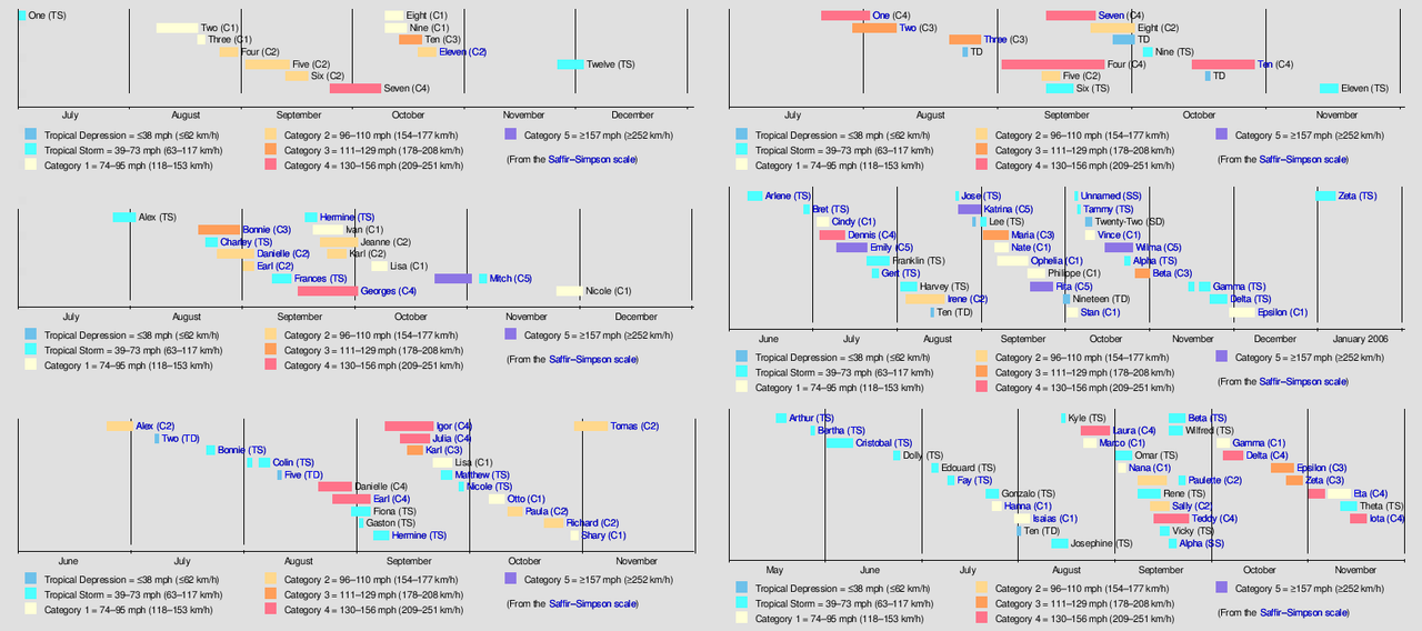
Going to disagree simply because we are far beyond normal climo with the extent of the warming in the NATL this year. We had similar levels of warming last year and the NATL managed to form 3 TS and a C1 during June & July in a strong Nino year.

Additionally, you shouldn't be comparing this to an average NATL year but to actual analogs e.g. from CSU's most recent forecast - 1878, 1926, 1998, 2005, 2010, and 2020

1878 - Very old and most likely missed several weaker systems, still has a TS
1926 - C4 & C3
1998 - TS
2005 - 4xTS, C1, C4 & C5
2010 - TS & C2
2020 - 7xTS, 2xC1

And as mentioned, we are no longer in normal climo range SST wise. We are pretty much in uncharted territory with the level of warmth in the oceans so the activity will come. We are still in mid-June and the season has just begun.

Image
Last edited by skyline385 on Fri Jun 14, 2024 5:36 pm, edited 1 time in total.
8 likes   

User avatar
Category5Kaiju
Category 5
Category 5
Posts: 4097
Joined: Thu Dec 24, 2020 12:45 pm
Location: Seattle

Re: 2024 Indicators: SST's, MSLP, Shear, SAL, Steering, Instability (Day 16+ Climate Models)

#1257 Postby Category5Kaiju » Fri Jun 14, 2024 5:20 pm

WiscoWx02 wrote:I highly doubt we are going to see much for activity for the rest of June and July is more than likely going to be quiet as well. Activity in these months is usually sloppy, short lived and subtropical...and for good reason. Even in the most favorable years, you are going to have shear and dry air hindering the tropics 99.9% of the time and stopping development. Now one can reply that hurricanes such as Dennis (05), Emily (05), Alex (10), Dolly (08) happened in June or July and say it isn't that uncommon, but when you compare that to the dozens of other seasons we have, they truly are exceptions on the more rare end. These storms happened because a handful of conditions just happened to align perfectly, and a tropical wave just happened to be there to take advantage of it. 99.9% of the time, conditions just don't line up like that in June and July and even if they do, you have to have a tropical wave under it and tracking just right.
Point is even in a year where conditions appear to be more favorable than normal like this one, you just can never expect to see tropical activity before August. If tropical activity does take place, more points to the Atlantic but I don't think it is ever something that should be expected.


I agree with a lot of points you've made. However.....there's a big caveat to consider in my opinion. There are some unique factors, including exceptionally warm tropical waters and an absolutely dead Eastern Pacific Ocean, that make this year a lot different from many recent years (and even analog years like 2005 and 2010, as those years had somewhat active EPAC seasons early on). These are quite the potent signals that would favor Atlantic activity and might have downstream impacts on mitigating many of the early season hurdles the basin faces, such as high wind shear and sinking air.

Now it's possible that your points stand and 2024 falls prey to climatology. There's definitely a nonzero chance of that happening. However, think the important thing to note is that IF we were ever to have a year when a powerful, atypical hurricane occurs during the months of June or July (especially in the Western Atlantic), given all the factors we know, 2024 looks to be a very viable candidate. This heightened possibility, even if it's nowhere near 100%, is why I think it's important that we are wary that this year might not behave like a lot of recent seasons, especially with regards to pre-August action.
5 likes   
Unless explicitly stated, all info in my posts is based on my own opinions and observations. Tropical storms and hurricanes can be extremely dangerous. Do not think you can beat Mother Nature. Refer to an accredited weather research agency or meteorologist if you need to make serious decisions regarding an approaching storm.

User avatar
NDG
S2K Supporter
S2K Supporter
Posts: 15446
Joined: Sun Jul 09, 2006 10:14 pm
Location: Orlando, FL

Re: 2024 Indicators: SST's, MSLP, Shear, SAL, Steering, Instability (Day 16+ Climate Models)

#1258 Postby NDG » Fri Jun 14, 2024 8:03 pm

I can't believe this was said this early on in the season and all people behind his post, lol.

 https://x.com/cyclonicwx/status/1801757822507528289

1 likes   

WeatherBoy2000
Category 1
Category 1
Posts: 346
Joined: Mon Apr 10, 2023 9:29 am

Re: 2024 Indicators: SST's, MSLP, Shear, SAL, Steering, Instability (Day 16+ Climate Models)

#1259 Postby WeatherBoy2000 » Fri Jun 14, 2024 8:45 pm

NDG wrote:I can't believe this was said this early on in the season and all people behind his post, lol.

 https://x.com/cyclonicwx/status/1801757822507528289


Since 2021 we've seen June mdr activity or at least the strong potential of it each year (Elsa, Bonnie-ish, Bret, and Cindy). I think people were expecting it to happen again due to a record warm Atlantic and building La Nina. It's important to note that none of Klotzbach's analogs had June mdr activity and they all turned out to be very active to even record-breaking seasons.
4 likes   

User avatar
cycloneye
Admin
Admin
Posts: 145323
Age: 68
Joined: Thu Oct 10, 2002 10:54 am
Location: San Juan, Puerto Rico

Re: 2024 Indicators: SST's, MSLP, Shear, SAL, Steering, Instability (Day 16+ Climate Models)

#1260 Postby cycloneye » Fri Jun 14, 2024 8:50 pm

1 likes   
Visit the Caribbean-Central America Weather Thread where you can find at first post web cams,radars
and observations from Caribbean basin members Click Here


Return to “Talkin' Tropics”

Who is online

Users browsing this forum: kevin, Majestic-12 [Bot] and 55 guests