Low pressure to organize over the Southwestern Gulf of Mexico (Is INVEST 91L)
Moderator: S2k Moderators
Forum rules

The posts in this forum are NOT official forecasts and should not be used as such. They are just the opinion of the poster and may or may not be backed by sound meteorological data. They are NOT endorsed by any professional institution or STORM2K. For official information, please refer to products from the National Hurricane Center and National Weather Service.


Re: Disturbance forecast to develop in the Southwestern Gulf (0/50)
The models are getting very interesting. GFS in particular. Houston, Austin and Central Texas get inundated so far in this run. Still early though.
1 likes
-
MEANINGLESS_NUMBERS
- Category 2

- Posts: 503
- Joined: Mon Nov 02, 2020 1:43 pm
Re: Disturbance forecast to develop in the Southwestern Gulf of Mexico (0/50)
GFS showing some areas with 24 inches of rain.
1 likes
Emily '87, Felix '95, Gert '99, Fabian '03, Humberto '19, Paulette '20, Teddy '20, Fiona '22, Lee '23, Ernesto '24, Humberto/Imelda '25

Re: Disturbance forecast to develop in the Southwestern Gulf of Mexico (0/50)
And after living in Houston for 25 years, that can easily go higher, much higher. Lived thru Allison (just a TS when it hit) and Harvey. Dont miss it at all.
2 likes
-
StormWeather

- Category 1

- Posts: 477
- Joined: Wed Jun 05, 2024 2:34 pm
Re: Disturbance forecast to develop in the Southwestern Gulf of Mexico (0/50)
The system has been upped to 60% in the 7 days timeframe now.
2 likes
Just an average cyclone tracker
The posts in this forum are NOT official forecasts and should not be used as such. They are just the opinion of the poster and may or may not be backed by sound meteorological data. They are NOT endorsed by any professional institution or storm2k.org. For official information, please refer to the NHC and NWS products
The posts in this forum are NOT official forecasts and should not be used as such. They are just the opinion of the poster and may or may not be backed by sound meteorological data. They are NOT endorsed by any professional institution or storm2k.org. For official information, please refer to the NHC and NWS products

Re: Disturbance forecast to develop in the Southwestern Gulf of Mexico (0/60)
I think the one thing in agreement here is its going to ne Wet next week on the Texas/LA coast 
0 likes
Harvey,Hanna,Beta,Texas Winter storm2021,Nicholas,Beryl
-
sphelps8681
- Category 2
- Posts: 785
- Joined: Thu Aug 16, 2007 5:37 pm
- Location: Somewhere over the rainbow
Re: Disturbance forecast to develop in the Southwestern Gulf of Mexico (0/60)
I am in SE Tx close to Beaumont and lA border. Looks like we are going to get some rain.
2 likes
-
Stratton23
- Category 5

- Posts: 3574
- Joined: Fri Jul 21, 2023 10:59 pm
- Location: Katy, Tx
Re: Disturbance forecast to develop in the Southwestern Gulf of Mexico (0/60)
This could be a major rain event for central and SE texas/ and parts of sw louisiana, because its a multi day event in this case 3-4 days, i am very concerned about some areas easily seeing more than a foot of rain given this extremely juicy tropical airmass coming
3 likes
Re: Low pressure trough moving into the Southwestern Gulf of Mexico (0/60)
GFS has been pretty bullish on the rainfall potential for a while now. Widespread 10+ inch totals along the Upper TX coast if the GFS is correct. Other models aren't showing as much rain though.
1 likes
-
Stratton23
- Category 5
- Posts: 3574
- Joined: Fri Jul 21, 2023 10:59 pm
- Location: Katy, Tx
Re: Low pressure trough moving into the Southwestern Gulf of Mexico (0/60)
Icytundra globals likely will be underestimating rain totals with tropical system, happens every time, some areas will likely exceed 10+ inches pretty easily out of this
1 likes
Re: Low pressure trough moving into the Southwestern Gulf of Mexico (0/60)
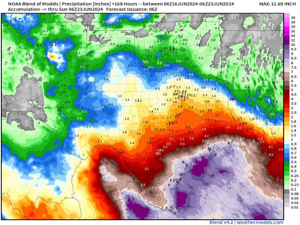
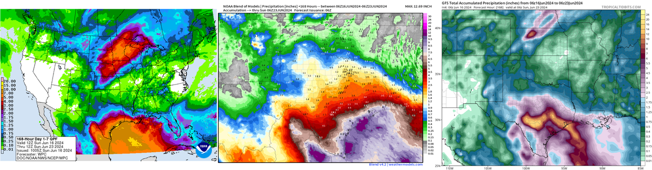
Nearly 16in of rain for Austin and about the same for Houston.  Still early though.
Still early though.
1 likes
-
skyline385

- Category 5
- Posts: 2728
- Age: 35
- Joined: Wed Aug 26, 2020 11:15 pm
- Location: Houston TX
Re: Low pressure trough moving into the Southwestern Gulf of Mexico (10/60)
TexasF6 wrote:Nearly 16in of rain for Austin and about the same for Houston.
I would suggest to ignore global models like GFS for this which generally overestimate rainfalls because of their coarse resolution. In my experience, the NBM (https://blend.mdl.nws.noaa.gov) is pretty accurate with rainfall estimates up to 7 days (it verified well for the recent SFL flooding as well) because it uses a blend of models and post-processed guidance.
1 likes
-
Stratton23
- Category 5
- Posts: 3574
- Joined: Fri Jul 21, 2023 10:59 pm
- Location: Katy, Tx
Re: Low pressure trough moving into the Southwestern Gulf of Mexico (10/60)
Skyline385 I wouldn’t disregard the GFS completely, in fact the WPC is going with the GFS solution, they really increased totals big time, with an area of 10-15 inches showing up on their new outlook that just came out an hour ago
0 likes
-
cycloneye

- Admin

- Posts: 149696
- Age: 69
- Joined: Thu Oct 10, 2002 10:54 am
- Location: San Juan, Puerto Rico
Re: Low pressure trough moving into the Southwestern Gulf of Mexico (10/60)
Southwestern Gulf of Mexico:
A large area of disturbed weather has formed over Central
America, the Yucatan Peninsula of Mexico, and the adjacent waters
of the northwestern Caribbean Sea. A broad area of low pressure is
forecast to form from this system over the southwestern Gulf of
Mexico in a day or two. Environmental conditions appear conducive
for gradual development of this system, and a tropical depression
could form by midweek while it moves slowly westward or
west-northwestward. Regardless of development, several days of
heavy rainfall are expected across portions of southern Mexico and
Central America. These rains are likely to cause life-threatening
flooding and flash flooding.
* Formation chance through 48 hours...low...10 percent.
* Formation chance through 7 days...medium...60 percent.

0 likes
Visit the Caribbean-Central America Weather Thread where you can find at first post web cams,radars
and observations from Caribbean basin members Click Here
and observations from Caribbean basin members Click Here
-
MEANINGLESS_NUMBERS
- Category 2
- Posts: 503
- Joined: Mon Nov 02, 2020 1:43 pm
Re: Low pressure trough moving into the Southwestern Gulf of Mexico (10/60)
06Z GFS has minimal development. Bit of a reality check after a few monstrous runs.
0 likes
Emily '87, Felix '95, Gert '99, Fabian '03, Humberto '19, Paulette '20, Teddy '20, Fiona '22, Lee '23, Ernesto '24, Humberto/Imelda '25
-
skyline385
- Category 5
- Posts: 2728
- Age: 35
- Joined: Wed Aug 26, 2020 11:15 pm
- Location: Houston TX
Re: RE: Re: Low pressure trough moving into the Southwestern Gulf of Mexico (10/60)
Stratton23 wrote:Skyline385 I wouldn’t disregard the GFS completely, in fact the WPC is going with the GFS solution, they really increased totals big time, with an area of 10-15 inches showing up on their new outlook that just came out an hour ago
WPC will use a blend of models to come up with their plot and not a single model which is what the NBM (National Blend of Models) also does. Also WPC's plot is pretty much exactly what NBM shows (10-15 inch rainfall concentrated in an area south of Houston followed by 7-10 inch for the rest of the Texas coast) and they did NOT go with the GFS solution which shows 14-16 inch of rain through Houston, College station, Austin and San Antonio which is what the original post was concerned about and I asked to ignore.
Remember that as we get further into the hurricane season it is very important to make sure none of us here are accidently spreading misinformation so always double check the data before posting.
Last edited by skyline385 on Sun Jun 16, 2024 9:58 am, edited 5 times in total.
3 likes

Re: Low pressure trough moving into the Southwestern Gulf of Mexico (10/60)
It never fails, development from the CAG always seems to take forever and models always struggle with it.
5 likes
-
TheAustinMan

- Category 5
- Posts: 1060
- Joined: Mon Jul 08, 2013 4:26 pm
- Location: Central TX / United States
Re: Low pressure trough moving into the Southwestern Gulf of Mexico (10/60)
The model depictions of this storm are reminiscent of Tropical Storm Arlene in 1993, which had similarly broad origins. Arlene actually reformed quite far to the northwest in the western Gulf of Mexico midway through its life, spinning up more impressively right next to the Texas coast before moving inland. Arlene ultimately wasn't very strong but was quite rainy for the western Gulf coast. The combination of strong ridging over the eastern United States and the broad low pressure associated with the Central American Gyre may result in a lot of vorticity on the northern periphery of the CAG where the height gradient is steepest, so a similar evolution is also possible this week.
Source: Wikimedia Commons / Wikipedia


https://www.youtube.com/watch?v=kNpn2u83VsA
Source: Wikimedia Commons / Wikipedia
https://www.youtube.com/watch?v=kNpn2u83VsA
3 likes
Treat my opinions with a grain of salt. For official information see your local weather service.
“It's tough to make predictions, especially about the future.”
“It's tough to make predictions, especially about the future.”
-
skyline385
- Category 5
- Posts: 2728
- Age: 35
- Joined: Wed Aug 26, 2020 11:15 pm
- Location: Houston TX
Re: Low pressure trough moving into the Southwestern Gulf of Mexico (10/60)
Moderate risk issued for around Houston and eastwards
https://x.com/NWSHouston/status/1802317284368683266
https://x.com/NWSHouston/status/1802317284368683266
1 likes
-
cycloneye
- Admin
- Posts: 149696
- Age: 69
- Joined: Thu Oct 10, 2002 10:54 am
- Location: San Juan, Puerto Rico
Re: Low pressure trough moving into the Southwestern Gulf of Mexico (10/60)
Starting on Monday afternoon, the squadron will begin missions.
ATLANTIC REQUIREMENTS
1. SUSPECT AREA (BAY OF CAMPECHE)
FLIGHT ONE - TEAL 71 FLIGHT TWO - TEAL 72
A. 17/1800Z A. 18/1130Z,1730Z
B. AFXXX 01AAA INVEST B. AFXXX 0201A CYCLONE
C. 17/1515Z C. 18/0915Z
D. 19.5N 92.0W D. 22.5N 93.5W
E. 17/1730Z TO 17/2230Z E. 18/1100Z TO 18/1730Z
F. SFC TO 10,000 FT F. SFC TO 10,000 FT
G. LOW-LEVEL INVEST G. FIX
H. NO WRA ACTIVATION H. WRA ACTIVATION
2. OUTLOOK FOR SUCCEEDING DAY:
A. CONTINUE 6-HRLY FIXES ON SUSPECT AREA IF SYSTEM DEVELOPS
AND IS A THREAT.
1 likes
Visit the Caribbean-Central America Weather Thread where you can find at first post web cams,radars
and observations from Caribbean basin members Click Here
and observations from Caribbean basin members Click Here
-
cycloneye
- Admin
- Posts: 149696
- Age: 69
- Joined: Thu Oct 10, 2002 10:54 am
- Location: San Juan, Puerto Rico
Re: Low pressure trough moving into the Southwestern Gulf of Mexico (30/70)
2 PM= 30/70.
Southwestern Gulf of Mexico:
A large area of disturbed weather is located over Central America,
the Yucatan Peninsula of Mexico, and the adjacent waters of the
northwestern Caribbean Sea. A broad area of low pressure is
forecast to form from this system over the southwestern Gulf of
Mexico on Monday or Tuesday. Environmental conditions appear
conducive for subsequent gradual development of the low, and a
tropical depression or tropical storm could form by midweek while
it moves slowly westward or west-northwestward.
Regardless of development, several days of heavy rainfall are
expected across portions of southern Mexico and Central America, and
these rains are likely to cause life-threatening flooding and flash
flooding. Locally heavy rainfall is also expected to spread over
portions of the northwestern coast of the Gulf of Mexico by the
middle of the week. In addition, gale warnings have been issued
for portions of the Gulf of Mexico, and more information on these
is available in High Seas Forecasts issued by the National Weather
Service.
* Formation chance through 48 hours...low...30 percent.
* Formation chance through 7 days...high...70 percent.
2 likes
Visit the Caribbean-Central America Weather Thread where you can find at first post web cams,radars
and observations from Caribbean basin members Click Here
and observations from Caribbean basin members Click Here
Who is online
Users browsing this forum: JtSmarts and 176 guests