
It's definitely a little chaotic in the western Atlantic right now lol. I imagine one of these storms will develop into something, even if very sloppy. The models are all over the place right now.skyline385 wrote:Decent chances for a TD on EPS
2024 Global Model Runs Discussion (Out thru day 16)
Moderator: S2k Moderators
Forum rules

The posts in this forum are NOT official forecasts and should not be used as such. They are just the opinion of the poster and may or may not be backed by sound meteorological data. They are NOT endorsed by any professional institution or STORM2K. For official information, please refer to products from the National Hurricane Center and National Weather Service.
Re: 2024 Global Model Runs Discussion (Out thru day 16)

0 likes
-
floridasun
- Tropical Storm

- Posts: 245
- Joined: Tue Sep 14, 2021 3:59 pm
Re: 2024 Global Model Runs Discussion (Out thru day 16)
other thing i was told coming from ex 90l that round Bahamas area east of it
0 likes
-
jlauderdal
- S2K Supporter

- Posts: 7240
- Joined: Wed May 19, 2004 5:46 am
- Location: NE Fort Lauderdale
- Contact:
Re: 2024 Global Model Runs Discussion (Out thru day 16)
Welcome back, are you ok after the flooding we had?floridasun wrote:other thing i was told coming from ex 90l that round Bahamas area east of it
0 likes
Re: 2024 Global Model Runs Discussion (Out thru day 16)
skyline385 wrote:LarryWx wrote:toad strangler wrote:
That track in mid June by itself would be anomalous for sure when citing standard basin climatology. A depression or weak TS taking this anomalous track wouldn’t be so surprising. As long as nothing more comes of it.
agreed:
History of TC landfalls from the E or SE to SE US May-June:
- 1873 minimal TS GA/FL border 6/2
- 1909 low end TS Ft. Lauderdale 6/28
- 1972 minimal STS Alpha Brunswick 5/27
- 1984 TD 1 St. Augustine 6/13
- 2012 high end TS Beryl Jacksonville 5/28
- 2016 TD Bonnie Isle of Palms, SC 5/29
- 2020 50 mph TS Bertha Isle of Palms, SC 5/27
Think you guys are missing the part about how the cut off low does a loop on the 12z ECMWF and then impacts both Palm Beach county and then into NOLA in mid-June. TS Bertha 2020 is our standard SE coast spin off crashing into the coast.
https://uploads.tapatalk-cdn.com/20240615/864044bc4570adbd154f4661906146cf.gif
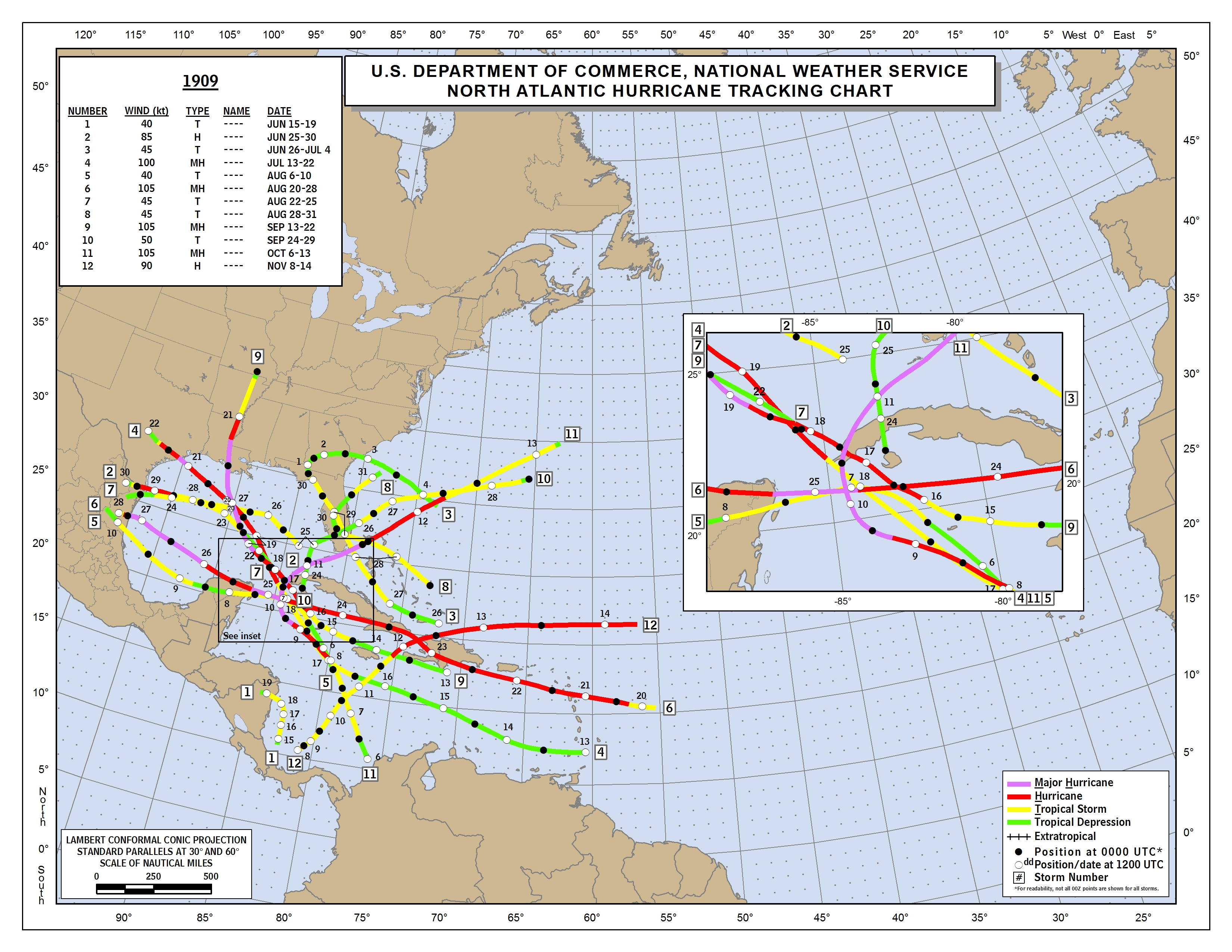
Yeah, that would be a rarity, especially in June. The most analogous tracks I could find amongst my list of May/June landfalls on the SE US would be:
-TS #2 of 1909 (Ft Lauderdale on 6/28 lower end TS)
https://www.nhc.noaa.gov/data/tracks/tracks-at-1909.png
-TD #1 in 1984 (St. Augustine on 6/13) potent/well organized giving 5” of rainfall to Jacksonville Beach)
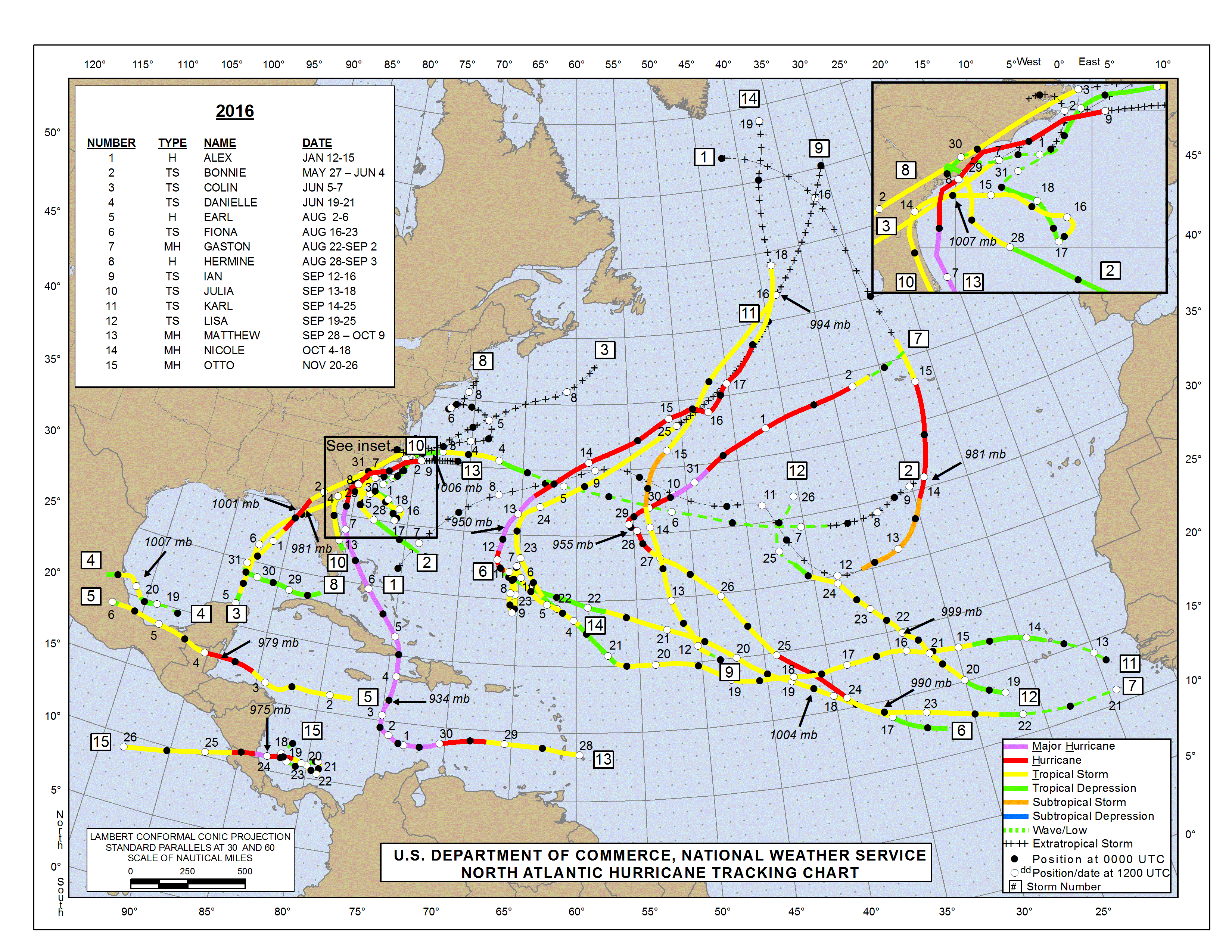
- TS Bonnie in 2016 (Isle of Palms on 5/29, where it weakened to TD at landfall)
https://www.nhc.noaa.gov/data/tracks/tracks-at-2016.png
The 18Z GFS, Euro, and ICON all have it though not quite closed on the ICON.
0 likes
Personal Forecast Disclaimer:
The posts in this forum are NOT official forecasts and should not be used as such. They are just the opinion of the poster and may or may not be backed by sound meteorological data. They are NOT endorsed by any professional institution or storm2k.org. For official information, please refer to the NHC and NWS products.
The posts in this forum are NOT official forecasts and should not be used as such. They are just the opinion of the poster and may or may not be backed by sound meteorological data. They are NOT endorsed by any professional institution or storm2k.org. For official information, please refer to the NHC and NWS products.

Re: 2024 Global Model Runs Discussion (Out thru day 16)
wxman57 wrote:The models are struggling to figure out what's happening in 2-3 days. Don't trust anything in the 7-12 day time frame.
Newly highlighted area east of FL is more like in the 3-5 day range.
2 likes
-
floridasun
- Tropical Storm
- Posts: 245
- Joined: Tue Sep 14, 2021 3:59 pm
Re: 2024 Global Model Runs Discussion (Out thru day 16)
my area dont get flood but other part Dade county did like miami beach and north Miami and Browardjlauderdal wrote:Welcome back, are you ok after the flooding we had?floridasun wrote:other thing i was told coming from ex 90l that round Bahamas area east of it
0 likes
-
AJC3

- Admin

- Posts: 4153
- Age: 62
- Joined: Tue Aug 31, 2004 7:04 pm
- Location: Ballston Spa, New York
- Contact:
Re: 2024 Global Model Runs Discussion (Out thru day 16)
Quick reminder that we now have separate threads for the systems forecast to develop over the SW GOMEX and SW Atlantic. From here on out, feel free to post about those soon-to-be systems in their respective threads.
The mods/admins thank you in advance for keeping the cross posting to a minimum, so we don't have to start moving posts.
The mods/admins thank you in advance for keeping the cross posting to a minimum, so we don't have to start moving posts.
4 likes

Re: 2024 Global Model Runs Discussion (Out thru day 16)
floridasun wrote:i am back was hospital for few weeks got new kindey was active on site doing off season of hurr season ok i was taking guys and ladys at hurricanetracker discord that gfs gone making ghost storm past few weeks we history of it doing that past we need see other major models come join gfs before we believe it
So true! The GFS can be a fantastic tool with regard to sniffing out potential increasingly favorable conditions for development but DO NOT take any GFS 4+ day forecast as gospel. On another note.... congratulations on the new kidney!! So few in need will ever receive such an unselfish gift. "Cheers" to that soul (and all other souls) willing and able to offer a gift of life.
3 likes
Andy D
(For official information, please refer to the NHC and NWS products.)
(For official information, please refer to the NHC and NWS products.)

Re: 2024 Global Model Runs Discussion (Out thru day 16)
LarryWx wrote:skyline385 wrote:LarryWx wrote:
agreed:
History of TC landfalls from the E or SE to SE US May-June:
- 1873 minimal TS GA/FL border 6/2
- 1909 low end TS Ft. Lauderdale 6/28
- 1972 minimal STS Alpha Brunswick 5/27
- 1984 TD 1 St. Augustine 6/13
- 2012 high end TS Beryl Jacksonville 5/28
- 2016 TD Bonnie Isle of Palms, SC 5/29
- 2020 50 mph TS Bertha Isle of Palms, SC 5/27
Think you guys are missing the part about how the cut off low does a loop on the 12z ECMWF and then impacts both Palm Beach county and then into NOLA in mid-June. TS Bertha 2020 is our standard SE coast spin off crashing into the coast.
https://uploads.tapatalk-cdn.com/20240615/864044bc4570adbd154f4661906146cf.gif
Yeah, that would be a rarity, especially in June. The most analogous tracks I could find amongst my list of May/June landfalls on the SE US would be:
-TS #2 of 1909 (Ft Lauderdale on 6/28 lower end TS)
https://www.nhc.noaa.gov/data/tracks/tracks-at-1909.png
-TD #1 in 1984 (St. Augustine on 6/13) potent/well organized giving 5” of rainfall to Jacksonville Beach)
- TS Bonnie in 2016 (Isle of Palms on 5/29, where it weakened to TD at landfall)
https://www.nhc.noaa.gov/data/tracks/tracks-at-2016.png
The 18Z GFS, Euro, and ICON all have it though not quite closed on the ICON.
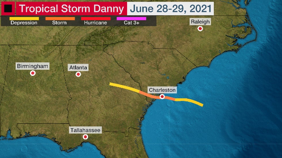
Danny in 2021 as well
3 likes
The above post is not official and should not be used as such. It is the opinion of the poster and may or may not be backed by sound meteorological data. It is not endorsed by any professional institution or storm2k.org. For official information, please refer to the NHC and NWS products.
-
skyline385

- Category 5

- Posts: 2728
- Age: 35
- Joined: Wed Aug 26, 2020 11:15 pm
- Location: Houston TX
Re: 2024 Global Model Runs Discussion (Out thru day 16)
The second BoC/GoM system from the leftover remnants of the 91L CAG which has been on and off on the GFS is now on the Euro as well
0 likes
-
cycloneye

- Admin
- Posts: 149275
- Age: 69
- Joined: Thu Oct 10, 2002 10:54 am
- Location: San Juan, Puerto Rico
Re: 2024 Global Model Runs Discussion (Out thru day 16)
2 likes
Visit the Caribbean-Central America Weather Thread where you can find at first post web cams,radars
and observations from Caribbean basin members Click Here
and observations from Caribbean basin members Click Here
-
Stratton23
- Category 5
- Posts: 3521
- Joined: Fri Jul 21, 2023 10:59 pm
- Location: Katy, Tx
Re: 2024 Global Model Runs Discussion (Out thru day 16)
We might see another lemon for the BOC/ western gulf in a few days, models are really starting to like this 2nd system a but more
0 likes

Re: 2024 Global Model Runs Discussion (Out thru day 16)
Stratton23 wrote:We might see another lemon for the BOC/ western gulf in a few days, models are really starting to like this 2nd system a but more
We already have a lemon for it lol
0 likes
-
cycloneye
- Admin
- Posts: 149275
- Age: 69
- Joined: Thu Oct 10, 2002 10:54 am
- Location: San Juan, Puerto Rico
Re: 2024 Global Model Runs Discussion (Out thru day 16)
Cpv17 wrote:Stratton23 wrote:We might see another lemon for the BOC/ western gulf in a few days, models are really starting to like this 2nd system a but more
We already have a lemon for it lol
He wrote that message before the 8 PM TWO.
0 likes
Visit the Caribbean-Central America Weather Thread where you can find at first post web cams,radars
and observations from Caribbean basin members Click Here
and observations from Caribbean basin members Click Here
-
REDHurricane

- Category 1

- Posts: 438
- Age: 28
- Joined: Sun Jul 03, 2022 2:36 pm
- Location: Northeast Pacific Ocean
Re: 2024 Global Model Runs Discussion (Out thru day 16)
18z GFS (operational & ensemble) surprisingly devoid of tropical activity through +384 hours... not that it really means anything at this point, but the pattern does appear to be set up for many of these upcoming systems to get pushed over land before they have a chance to develop into named storms, regardless of how favorable the environment is on either side of Central America.
0 likes
-
MEANINGLESS_NUMBERS
- Category 2

- Posts: 503
- Joined: Mon Nov 02, 2020 1:43 pm
Re: 2024 Global Model Runs Discussion (Out thru day 16)
REDHurricane wrote:18z GFS (operational & ensemble) surprisingly devoid of tropical activity through +384 hours... not that it really means anything at this point, but the pattern does appear to be set up for many of these upcoming systems to get pushed over land before they have a chance to develop into named storms, regardless of how favorable the environment is on either side of Central America.
https://media4.giphy.com/media/v1.Y2lkPTc5MGI3NjExdjdqaDJmZ2dibmxlc2doNTF3a2lkaHBmOTEyNnRhMWM4N3UzNGFheiZlcD12MV9pbnRlcm5hbF9naWZfYnlfaWQmY3Q9Zw/TutB9DRSFzc9Z38HNZ/giphy.gif
https://media2.giphy.com/media/v1.Y2lkPTc5MGI3NjExZnhnd2pwejF1bnFmZzVyYTYwb3hyenBwdG9wNGJwYmVuZXI4YnRkMSZlcD12MV9pbnRlcm5hbF9naWZfYnlfaWQmY3Q9Zw/2vMR0X9uODklIpymT1/giphy.gif
Looks like typical June.
0 likes
Emily '87, Felix '95, Gert '99, Fabian '03, Humberto '19, Paulette '20, Teddy '20, Fiona '22, Lee '23, Ernesto '24, Humberto/Imelda '25
-
skyline385
- Category 5
- Posts: 2728
- Age: 35
- Joined: Wed Aug 26, 2020 11:15 pm
- Location: Houston TX
Re: 2024 Global Model Runs Discussion (Out thru day 16)
MEANINGLESS_NUMBERS wrote:REDHurricane wrote:18z GFS (operational & ensemble) surprisingly devoid of tropical activity through +384 hours... not that it really means anything at this point, but the pattern does appear to be set up for many of these upcoming systems to get pushed over land before they have a chance to develop into named storms, regardless of how favorable the environment is on either side of Central America.
https://media4.giphy.com/media/v1.Y2lkPTc5MGI3NjExdjdqaDJmZ2dibmxlc2doNTF3a2lkaHBmOTEyNnRhMWM4N3UzNGFheiZlcD12MV9pbnRlcm5hbF9naWZfYnlfaWQmY3Q9Zw/TutB9DRSFzc9Z38HNZ/giphy.gif
https://media2.giphy.com/media/v1.Y2lkPTc5MGI3NjExZnhnd2pwejF1bnFmZzVyYTYwb3hyenBwdG9wNGJwYmVuZXI4YnRkMSZlcD12MV9pbnRlcm5hbF9naWZfYnlfaWQmY3Q9Zw/2vMR0X9uODklIpymT1/giphy.gif
Looks like typical June.
Folks were saying the same before PTC 1 and the rest of the AOIs. Fact of the matter is that this is not a typical year and we are literally in uncharted territory with the amount of warmth the NATL has. Last year this same warmth was responsible for shutting down the WPAC in September in a Nino year which is basically unheard of. Models will not always catch onto signals, and they are prone to flipping at any time just like they did with PTC 1 so looking at GFS 384hrs is fine but I wouldn't take it as gospel.
1 likes
-
REDHurricane
- Category 1
- Posts: 438
- Age: 28
- Joined: Sun Jul 03, 2022 2:36 pm
- Location: Northeast Pacific Ocean
Re: 2024 Global Model Runs Discussion (Out thru day 16)
skyline385 wrote:MEANINGLESS_NUMBERS wrote: Looks like typical June.
Folks were saying the same before PTC 1 and the rest of the AOIs. Fact of the matter is that this is not a typical year and we are literally in uncharted territory with the amount of warmth the NATL has. Last year this same warmth was responsible for shutting down the WPAC in September in a Nino year which is basically unheard of. Models will not always catch onto signals, and they are prone to flipping at any time just like they did with PTC 1 so looking at GFS 384hrs is fine but I wouldn't take it as gospel.
100% agreed -- just thought it was interesting that, despite the highly favorable conditions and the GFS' infamous affinity for spinning up phantom CAG storms, the past few GFS runs aren't showing any activity at all. To me, it looks like the the models as a whole actually have caught on to a signal of favorability but strong subtropical ridging keeps pushing these potential TCs west into Central America before they have the chance to develop. Any slight change in the forecast conditions could certainly make the difference between models predicting no activity and the GFS repeatedly trying to hit Florida with nonsense Cat 5s in June/July, but I do think it's something to take note of when watching the tropics over the next few weeks regardless.
0 likes
-
DorkyMcDorkface

- Category 4

- Posts: 988
- Age: 28
- Joined: Mon Sep 30, 2019 1:32 pm
- Location: Mid-Atlantic
Re: 2024 Global Model Runs Discussion (Out thru day 16)
In addition to support for the 0/30 in the Gulf and increased support for the 20/20 in the SW Atlantic, there are signals in the WCarib and MDR in the long range.

2 likes
Please note the thougths expressed by this account are solely those of the user and are from a hobbyist perspective. For more comprehensive analysis, consult an actual professional meteorologist or meteorology agency.
Floyd 1999 | Isabel 2003 | Hanna 2008 | Irene 2011 | Sandy 2012 | Isaias 2020
-
skyline385
- Category 5
- Posts: 2728
- Age: 35
- Joined: Wed Aug 26, 2020 11:15 pm
- Location: Houston TX
Re: 2024 Global Model Runs Discussion (Out thru day 16)
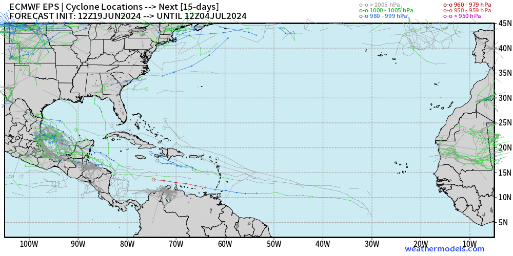
Full plot of the 12z EPS, looks like there will be a couple of waves in the MDR which might be worth watching
1 likes
Who is online
Users browsing this forum: No registered users and 428 guests