2024 Indicators: SST's, MSLP, Shear, SAL, Steering, Instability (Day 16+ Climate Models)
Moderator: S2k Moderators
Forum rules

The posts in this forum are NOT official forecasts and should not be used as such. They are just the opinion of the poster and may or may not be backed by sound meteorological data. They are NOT endorsed by any professional institution or STORM2K. For official information, please refer to products from the National Hurricane Center and National Weather Service.


Re: 2024 Indicators: SST's, MSLP, Shear, SAL, Steering, Instability (Day 16+ Climate Models)
That is a really good point about the MDR suppression. I didn't think about how those two seasons were far more west oriented. I'm not sure if that's a good thing for us humans though...
0 likes
-
skyline385

- Category 5

- Posts: 2728
- Age: 35
- Joined: Wed Aug 26, 2020 11:15 pm
- Location: Houston TX
Re: RE: Re: 2024 Indicators: SST's, MSLP, Shear, SAL, Steering, Instability (Day 16+ Climate Models)
Woofde wrote:I think its one of those areas that needs more research. I remember earlier when we had a strong Atlantic Nino people were also saying it could cause suppression.WiscoWx02 wrote:https://x.com/BenNollWeather/status/1802776517652684956
Ben talks about how a Atlantic "Nina" tends to suppress activity in the Atlantic...just something interesting to note going forward. Always something to play devils advocate with.
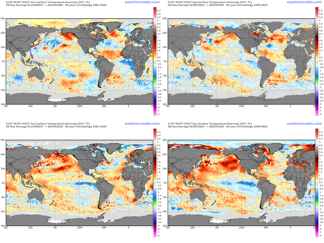
2005 and 2020 sported the same Atl. Nina look. If the two most active seasons both had it, I doubt it's too much of a detriment.https://uploads.tapatalk-cdn.com/20240617/33938905a34f88eb55177354b853391e.jpg https://uploads.tapatalk-cdn.com/20240617/d8668ceac146ec40642409a6822d0b8d.jpg
Lots of things to go through here:
1) You should almost never look at 1-day SSTa because they can be misleading particularly in the case of 2020 where there was nowhere as strong of an Atlantic Nina in June as that screenshot suggests.
2) Atlantic Nina tends to pop up strong during June and weaken in lots of years as we head towards peak season and September which is peak month for MDR activity.
3) Atlantic Nina as said already is still being researched but the general consensus is that it lowers MDR activity which is also seen in the two years you mentioned. Most recent paper on this - https://www.nature.com/articles/s41467-023-39467-5
28-day averaged SSTa plots for June and September for 2005 and 2020
3 likes
-
WeatherBoy2000
- Category 1

- Posts: 460
- Joined: Mon Apr 10, 2023 9:29 am
Re: RE: Re: 2024 Indicators: SST's, MSLP, Shear, SAL, Steering, Instability (Day 16+ Climate Models)
Hurricane2022 wrote:Woofde wrote:I think its one of those areas that needs more research. I remember earlier when we had a strong Atlantic Nino people were also saying it could cause suppression.WiscoWx02 wrote: https://x.com/BenNollWeather/status/1802776517652684956
Ben talks about how a Atlantic "Nina" tends to suppress activity in the Atlantic...just something interesting to note going forward. Always something to play devils advocate with.
2005 and 2020 sported the same Atl. Nina look. If the two most active seasons both had it, I doubt it's too much of a detriment.https://uploads.tapatalk-cdn.com/20240617/33938905a34f88eb55177354b853391e.jpg https://uploads.tapatalk-cdn.com/20240617/d8668ceac146ec40642409a6822d0b8d.jpg
But both seasons did not have a lot of strong hurricane activity in the MDR. In 2005, the strongest storm in this region was Maria (C3), and in 2020 it was Teddy (C4). Both were the only major hurricanes in these areas in the respective years mentioned. If this year we do have the Atlantic Nina, I imagine that the MDR may be a little less active than anticipated
The two highly active years prior to 2005 (2003/2004) also had cooler atl nino regions at this time:
Both were big CV seasons, especially 2004. I don't think it's as clear-cut as Atlantic nina supresses mdr activity while Atlantic nino enhances it. As someone else has already said, the Atlantic nino region may not be all that important compared to other factors like enso and the amo.
3 likes
-
skyline385
- Category 5
- Posts: 2728
- Age: 35
- Joined: Wed Aug 26, 2020 11:15 pm
- Location: Houston TX
Re: RE: Re: 2024 Indicators: SST's, MSLP, Shear, SAL, Steering, Instability (Day 16+ Climate Models)
WeatherBoy2000 wrote:Hurricane2022 wrote:Woofde wrote:I think its one of those areas that needs more research. I remember earlier when we had a strong Atlantic Nino people were also saying it could cause suppression.
2005 and 2020 sported the same Atl. Nina look. If the two most active seasons both had it, I doubt it's too much of a detriment.https://uploads.tapatalk-cdn.com/20240617/33938905a34f88eb55177354b853391e.jpg https://uploads.tapatalk-cdn.com/20240617/d8668ceac146ec40642409a6822d0b8d.jpg
But both seasons did not have a lot of strong hurricane activity in the MDR. In 2005, the strongest storm in this region was Maria (C3), and in 2020 it was Teddy (C4). Both were the only major hurricanes in these areas in the respective years mentioned. If this year we do have the Atlantic Nina, I imagine that the MDR may be a little less active than anticipated
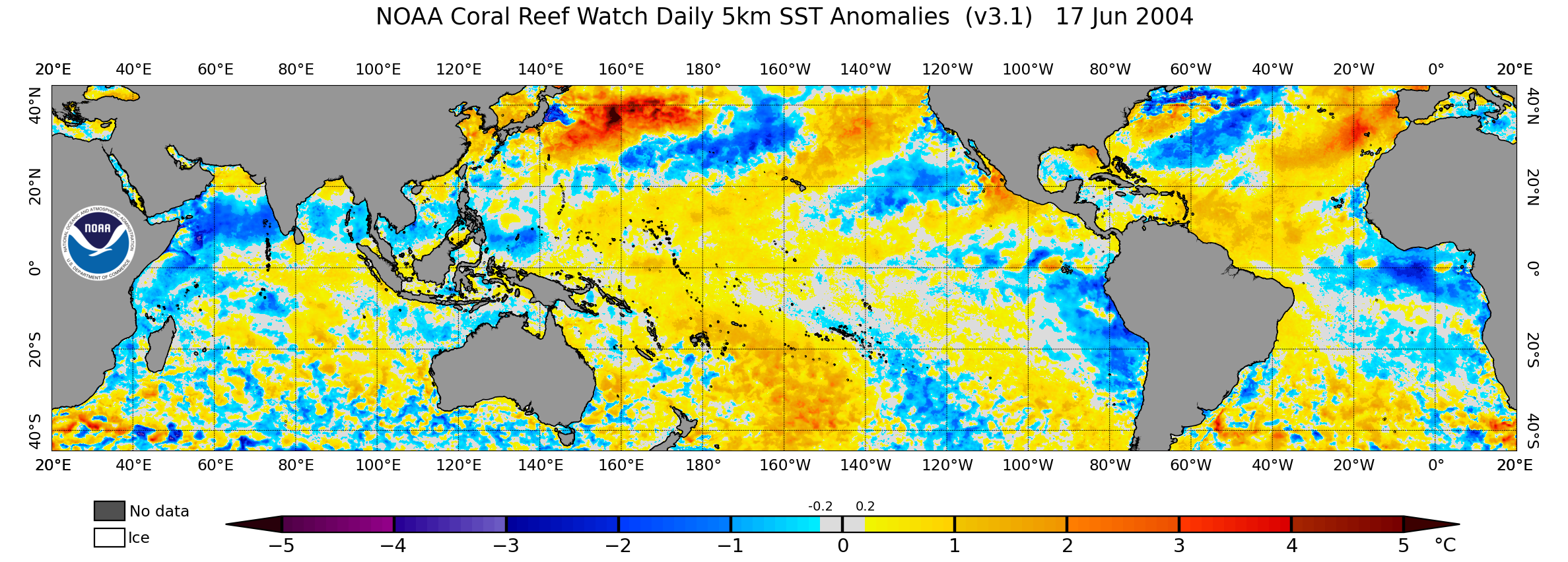
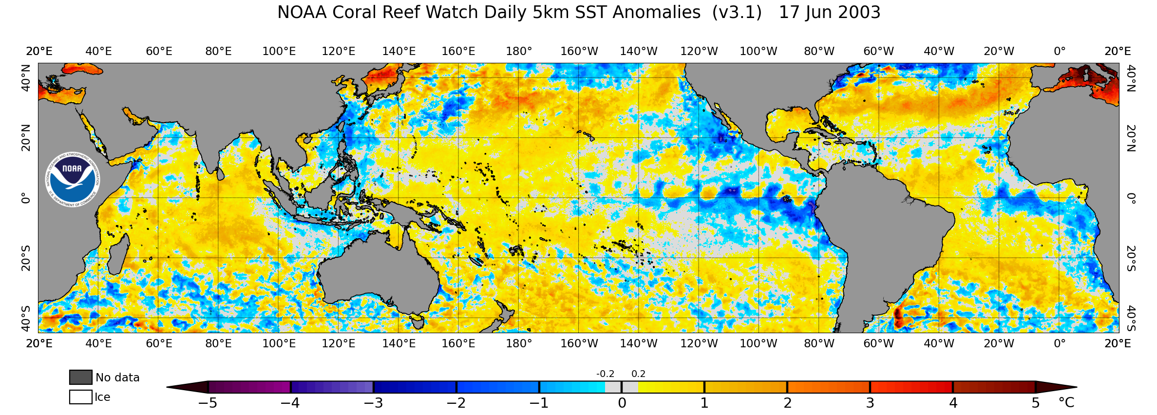
The two highly active years prior to 2005 (2003/2004) also had cooler atl nino regions at this time:
https://www.coralreefwatch.noaa.gov/data/5km/v3.1_op/image/daily/ssta/png/2004/06/ct5km_ssta_v3.1_tropics_20040617.png
https://www.coralreefwatch.noaa.gov/data/5km/v3.1_op/image/daily/ssta/png/2003/06/ct5km_ssta_v3.1_tropics_20030617.png
Both were big CV seasons, especially 2004. I don't think it's as clear-cut as Atlantic nina supresses mdr activity while Atlantic nino enhances it. As someone else has already said, the Atlantic nino region may not be all that important compared to other factors like enso and the amo.
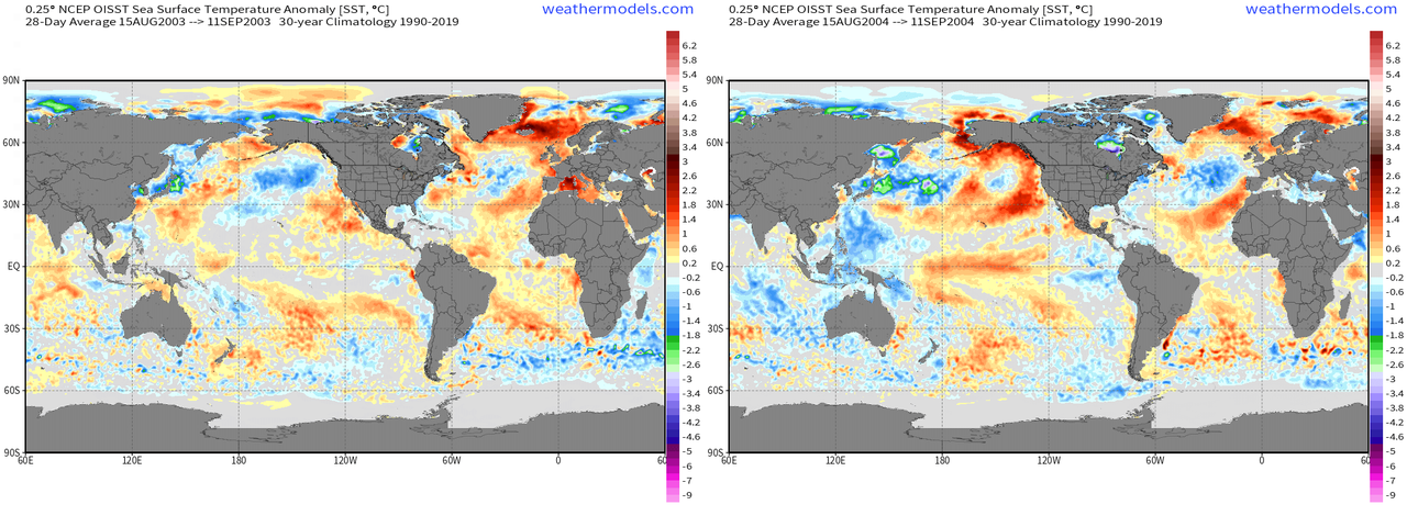
Check out my comment above yours for how Atlantic Nina transition into peak seasons. Here is how 2003 and 2004 looked past Aug 15 which is when both seasons saw MDR activity.
2 likes

Re: 2024 Indicators: SST's, MSLP, Shear, SAL, Steering, Instability (Day 16+ Climate Models)
This is also a good time for a reminder: 2020's relatively quieter-than-expected MDR season may have more to do with "well-timed" TUTTs induced by three recurring typhoons (Bavi, Maysak, Haishen), rather than internal factors within the Atlantic. This is a rare event especially in years with expectations of a quieter WPAC, and is unpredictable in advance.
I feel that any attempts to explain 2020's MDR using Atlantic indicators, much less extrapolate them to other seasons, are incomplete because of this.
I feel that any attempts to explain 2020's MDR using Atlantic indicators, much less extrapolate them to other seasons, are incomplete because of this.
4 likes
TC naming lists: retirements and intensity
Most aggressive Advisory #1's in North Atlantic (cr. kevin for starting the list)
Most aggressive Advisory #1's in North Atlantic (cr. kevin for starting the list)
-
skyline385
- Category 5
- Posts: 2728
- Age: 35
- Joined: Wed Aug 26, 2020 11:15 pm
- Location: Houston TX
Re: 2024 Indicators: SST's, MSLP, Shear, SAL, Steering, Instability (Day 16+ Climate Models)
Teban54 wrote:This is also a good time for a reminder: 2020's relatively quieter-than-expected MDR season may have more to do with "well-timed" TUTTs induced by three recurring typhoons (Bavi, Maysak, Haishen), rather than internal factors within the Atlantic. This is a rare event especially in years with expectations of a quieter WPAC, and is unpredictable in advance.
I feel that any attempts to explain 2020's MDR using Atlantic indicators, much less extrapolate them to other seasons, are incomplete because of this.
That is a good point, also 2020 had a very SAL heavy early season including record breaking outbreaks which also made development in the MDR harder when combined with shear from the TUTT
0 likes
-
Category5Kaiju

- Category 5
- Posts: 4331
- Joined: Thu Dec 24, 2020 12:45 pm
- Location: Seattle and Phoenix
Re: 2024 Indicators: SST's, MSLP, Shear, SAL, Steering, Instability (Day 16+ Climate Models)
skyline385 wrote:Teban54 wrote:This is also a good time for a reminder: 2020's relatively quieter-than-expected MDR season may have more to do with "well-timed" TUTTs induced by three recurring typhoons (Bavi, Maysak, Haishen), rather than internal factors within the Atlantic. This is a rare event especially in years with expectations of a quieter WPAC, and is unpredictable in advance.
I feel that any attempts to explain 2020's MDR using Atlantic indicators, much less extrapolate them to other seasons, are incomplete because of this.
That is a good point, also 2020 had a very SAL heavy early season including record breaking outbreaks which also made development in the MDR harder when combined with shear from the TUTT
Looking back at 2020, it's honestly quite interesting to see how its sst anomaly configuration really wasn't all that impressive, especially if you compare it with a year like 2010 or this year. The tropical warmth was there, but the subtropics were also warm, and you even had this period where the area between the deep tropics and the subtropics had near average sst anomalies.
What's funny is I specifically recall talk back then about how the sst anomalies meant extremely active season and all that jazz. Which, while it did pan out in the sense we got 30 storms, also came with some deficiences in seasonal performance (like sub-200 ACE, lack of many long-tracked MDR systems, etc.)
Whatever the case, I think there are a lot more positive factors that are in play that might drive this season compared to 2020, and it goes beyond the sst anomaly maps.
2 likes
Unless explicitly stated, all info in my posts is based on my own opinions and observations. Tropical storms and hurricanes can be extremely dangerous. Refer to an accredited weather research agency or meteorologist if you need to make serious decisions regarding an approaching storm.
Re: RE: Re: RE: Re: 2024 Indicators: SST's, MSLP, Shear, SAL, Steering, Instability (Day 16+ Climate Models)
If the climate models are to be believed, then this Atlantic nina is short-lived anyway. NMME, Cansips, and the CFS all show it dissipating. I doubt it will be a significant factor for this season overall. I do understand why people are looking for potential negatives. They are hard to find with most indicators.skyline385 wrote:WeatherBoy2000 wrote:Hurricane2022 wrote:But both seasons did not have a lot of strong hurricane activity in the MDR. In 2005, the strongest storm in this region was Maria (C3), and in 2020 it was Teddy (C4). Both were the only major hurricanes in these areas in the respective years mentioned. If this year we do have the Atlantic Nina, I imagine that the MDR may be a little less active than anticipated
The two highly active years prior to 2005 (2003/2004) also had cooler atl nino regions at this time:
https://www.coralreefwatch.noaa.gov/data/5km/v3.1_op/image/daily/ssta/png/2004/06/ct5km_ssta_v3.1_tropics_20040617.png
https://www.coralreefwatch.noaa.gov/data/5km/v3.1_op/image/daily/ssta/png/2003/06/ct5km_ssta_v3.1_tropics_20030617.png
Both were big CV seasons, especially 2004. I don't think it's as clear-cut as Atlantic nina supresses mdr activity while Atlantic nino enhances it. As someone else has already said, the Atlantic nino region may not be all that important compared to other factors like enso and the amo.
Check out my comment above yours for how Atlantic Nina transition into peak seasons. Here is how 2003 and 2004 looked past Aug 15 which is when both seasons saw MDR activity.
This Atl Nina look only very recently popped up. As you stated, we need to see this look for a sustained period, not just a few weeks. Only then can we gauge whether it's a real part of the pattern, or just something in the short term.


4 likes
Re: 2024 Indicators: SST's, MSLP, Shear, SAL, Steering, Instability (Day 16+ Climate Models)
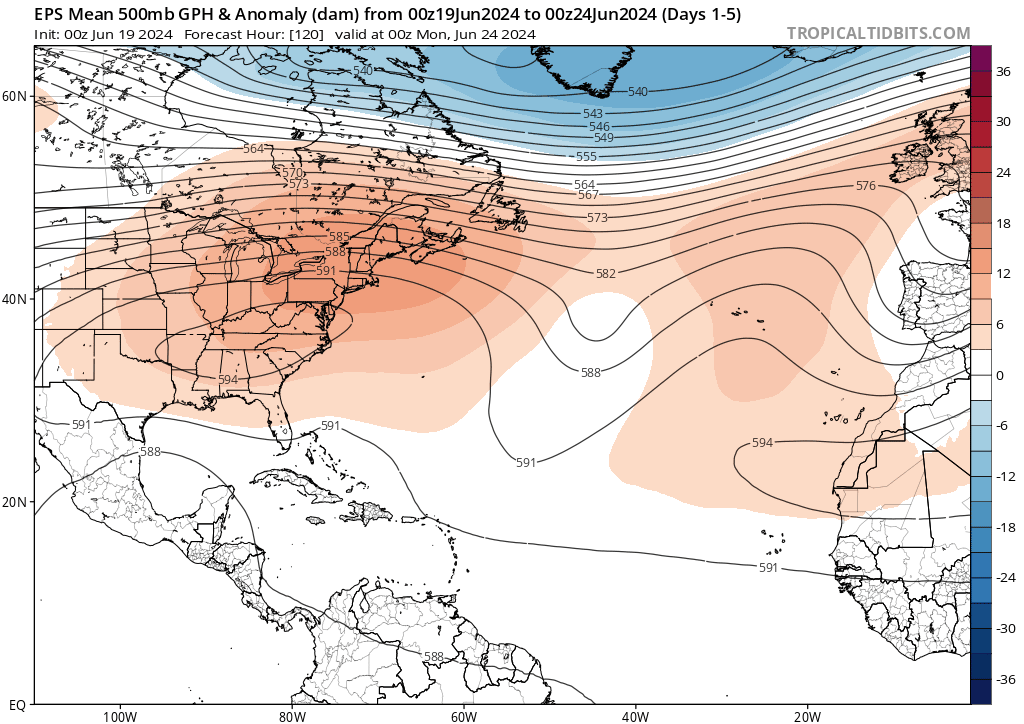
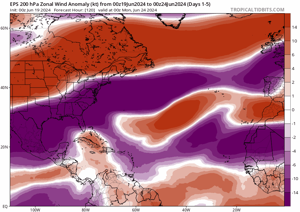
The east coast-Atlantic ridge causes persistent wavebreaking, see the upper lows near 20N.
Also, that equatorial westerly anomaly doesn't look like Nina at all. You need the tropical forcing to activate the MDR when ET forcing isn't cooperating.
4 likes
-
skyline385
- Category 5
- Posts: 2728
- Age: 35
- Joined: Wed Aug 26, 2020 11:15 pm
- Location: Houston TX
Re: 2024 Indicators: SST's, MSLP, Shear, SAL, Steering, Instability (Day 16+ Climate Models)
The two other years are complete opposite ACE wise lol
https://x.com/philklotzbach/status/1803551492844167371
https://x.com/philklotzbach/status/1803551492844167371
0 likes
-
tolakram
- Admin

- Posts: 20178
- Age: 62
- Joined: Sun Aug 27, 2006 8:23 pm
- Location: Florence, KY (name is Mark)
Re: 2024 Indicators: SST's, MSLP, Shear, SAL, Steering, Instability (Day 16+ Climate Models)
skyline385 wrote:The two other years are complete opposite ACE wise lol
https://x.com/philklotzbach/status/1803551492844167371
For the entire northern hemisphere?
0 likes
M a r k
- - - - -
Join us in chat: Storm2K Chatroom Invite. Android and IOS apps also available.
The posts in this forum are NOT official forecasts and should not be used as such. Posts are NOT endorsed by any professional institution or STORM2K.org. For official information and forecasts, please refer to NHC and NWS products.
-
skyline385
- Category 5
- Posts: 2728
- Age: 35
- Joined: Wed Aug 26, 2020 11:15 pm
- Location: Houston TX
Re: 2024 Indicators: SST's, MSLP, Shear, SAL, Steering, Instability (Day 16+ Climate Models)
tolakram wrote:skyline385 wrote:The two other years are complete opposite ACE wise lol
https://x.com/philklotzbach/status/1803551492844167371
For the entire northern hemisphere?
Nah, I meant for the NATL. 1977 was pretty much dead (with the big exception of Anita) ending in 25 ACE and 2017 was 2017 with 224 ACE.
Last edited by skyline385 on Wed Jun 19, 2024 9:13 pm, edited 1 time in total.
0 likes
-
Category5Kaiju
- Category 5
- Posts: 4331
- Joined: Thu Dec 24, 2020 12:45 pm
- Location: Seattle and Phoenix
Re: 2024 Indicators: SST's, MSLP, Shear, SAL, Steering, Instability (Day 16+ Climate Models)
skyline385 wrote:The two other years are complete opposite ACE wise lol
https://x.com/philklotzbach/status/1803551492844167371
With the WPAC and EPAC being very quiet, it's not surprising that that's the case. In a typical year, by now at least of of those basins has already produced a major-strength cyclone.
Also interesting to note that both of those years were notable in how the WPAC failed to produced a Cat 5-equivalent super typhoon, a feat that very rarely occurs.
2 likes
Unless explicitly stated, all info in my posts is based on my own opinions and observations. Tropical storms and hurricanes can be extremely dangerous. Refer to an accredited weather research agency or meteorologist if you need to make serious decisions regarding an approaching storm.

Re: 2024 Indicators: SST's, MSLP, Shear, SAL, Steering, Instability (Day 16+ Climate Models)
Just for fun and to see how favorable the environment generally is (or is expected to be), here are all the TCs forming in the latest CFS run out to 768 hr (July 22). Note that these long-term models usually are extremely conservative in terms of intensity. And that due to the timeframe it won't happen like this anyways, but it's just an interesting experiment.
Beryl: June 22 - 24, 1005 mb, weak TS in the BOC (current area of interest).
Chris: June 28 - July 3, 1010 mb, first MDR storm, hits Puerto Rico as a TS, afterwards travels to Florida as an open wave.
Debby: July 10 - July 20, 1005 mb, long-lived CV TC, curves away just north of the islands and also curves away just before hitting any US territory. Hits Newfoundland as an ET cyclone.
At the final time frame on July 22 (+768) another closed low forms in the eastern MDR which could become Ernesto.
I'm not sure how realistic these CFS runs are, but if there is anything we can take away from it I'd say it's that we should keep an eye on the MDR (more than we usually do in June/July). With the extremely warm water I wouldn't be surprised if we get some early MDR/CV storms when SAL & shear decrease.
4 likes
-
Pas_Bon
- Tropical Depression

- Posts: 87
- Age: 46
- Joined: Mon Jul 15, 2019 12:25 pm
- Location: League City, TX
Re: 2024 Indicators: SST's, MSLP, Shear, SAL, Steering, Instability (Day 16+ Climate Models)
kevin wrote:Just for fun and to see how favorable the environment generally is (or is expected to be), here are all the TCs forming in the latest CFS run out to 768 hr (July 22). Note that these long-term models usually are extremely conservative in terms of intensity. And that due to the timeframe it won't happen like this anyways, but it's just an interesting experiment.
Beryl: June 22 - 24, 1005 mb, weak TS in the BOC (current area of interest).
Chris: June 28 - July 3, 1010 mb, first MDR storm, hits Puerto Rico as a TS, afterwards travels to Florida as an open wave.
Debby: July 10 - July 20, 1005 mb, long-lived CV TC, curves away just north of the islands and also curves away just before hitting any US territory. Hits Newfoundland as an ET cyclone.
At the final time frame on July 22 (+768) another closed low forms in the eastern MDR which could become Ernesto.
I'm not sure how realistic these CFS runs are, but if there is anything we can take away from it I'd say it's that we should keep an eye on the MDR (more than we usually do in June/July). With the extremely warm water I wouldn't be surprised if we get some early MDR/CV storms when SAL & shear decrease.
That would be really weird to see an extra-terrestrial cyclone
3 likes
Re: 2024 Indicators: SST's, MSLP, Shear, SAL, Steering, Instability (Day 16+ Climate Models)
June landfalls NE MX N of 20N/ENSO/E US winter
2024: Alberto TS + possible 2nd/likely Nina/TBD
2016: Danielle TS/mod Niña/mild
2011: Arlene TS/mod Niña/mild
2010: Alex H/strong Niña/cold
2005: Bret TS/weak Niña/normal
1959: Beulah TD/neutral/mild
1958: Alma TS/weak Nino/cool to cold
1954: Alice H/weak Niña/normal
1936: #2 TS/neutral/mild
1924: #1 TS/mod Niña/normal to mild
1922: #1 TS/cold neutral/cool to mild
1865: #2 TS/weak Nino/no data
The # of CONUS hurricane landfalls for those seasons averaged near normal (2.2) but were all over the map (0 to 6).
Year: CONUS H landfalls
2024: TBD
2016: 2
2011: 1
2010: 0
2005: 6
1959: 3
1958: 1
1954: 3
1936: 3
1924: 3
1922: 0
1865: 2
3 likes
Personal Forecast Disclaimer:
The posts in this forum are NOT official forecasts and should not be used as such. They are just the opinion of the poster and may or may not be backed by sound meteorological data. They are NOT endorsed by any professional institution or storm2k.org. For official information, please refer to the NHC and NWS products.
The posts in this forum are NOT official forecasts and should not be used as such. They are just the opinion of the poster and may or may not be backed by sound meteorological data. They are NOT endorsed by any professional institution or storm2k.org. For official information, please refer to the NHC and NWS products.
-
USTropics
- Professional-Met

- Posts: 2737
- Joined: Sun Aug 12, 2007 3:45 am
- Location: Florida State University
Re: 2024 Indicators: SST's, MSLP, Shear, SAL, Steering, Instability (Day 16+ Climate Models)
LarryWx wrote:June landfalls NE MX N of 20N/ENSO/E US winter
2024: Alberto TS + possible 2nd/likely Nina/TBD
2016: Danielle TS/mod Niña/mild
2011: Arlene TS/mod Niña/mild
2010: Alex H/strong Niña/cold
2005: Bret TS/weak Niña/normal
1959: Beulah TD/neutral/mild
1958: Alma TS/weak Nino/cool to cold
1954: Alice H/weak Niña/normal
1936: #2 TS/neutral/mild
1924: #1 TS/mod Niña/normal to mild
1922: #1 TS/cold neutral/cool to mild
1865: #2 TS/weak Nino/no data
The # of CONUS hurricane landfalls for those seasons averaged near normal (2.2) but were all over the map (0 to 6).
Year: CONUS H landfalls
2024: TBD
2016: 2
2011: 1
2010: 0
2005: 6
1959: 3
1958: 1
1954: 3
1936: 3
1924: 3
1922: 0
1865: 2
As always, thanks for the indepth research you do Larry. As stated previously, the correlation between June activity in the western Atlantic and total season activity is rather low—CAG systems in June (unlike in October) typically have little influence from AEWs. With that said, I think its telling that the CAG event this June was heavily focused in the Atlantic/GOM vs. the EPAC (and attributable to the SSTA regime).
7 likes
-
cycloneye

- Admin
- Posts: 149275
- Age: 69
- Joined: Thu Oct 10, 2002 10:54 am
- Location: San Juan, Puerto Rico
Re: 2024 Indicators: SST's, MSLP, Shear, SAL, Steering, Instability (Day 16+ Climate Models)
1 likes
Visit the Caribbean-Central America Weather Thread where you can find at first post web cams,radars
and observations from Caribbean basin members Click Here
and observations from Caribbean basin members Click Here
-
Deshaunrob17
- Tropical Storm

- Posts: 211
- Joined: Tue Aug 18, 2020 7:49 am
Re: 2024 Indicators: SST's, MSLP, Shear, SAL, Steering, Instability (Day 16+ Climate Models)
There is a wave will approach the Lesser Antillies next weekend. That seems like a good candidate for tropical development. Slowly growing support in fhd ensemble camps. Globals have it as a pretty amplified wave. Still plenty of time to watch.
1 likes
-
SFLcane

- S2K Supporter

- Posts: 10281
- Age: 48
- Joined: Sat Jun 05, 2010 1:44 pm
- Location: Lake Worth Florida
Re: 2024 Indicators: SST's, MSLP, Shear, SAL, Steering, Instability (Day 16+ Climate Models)
Looking long range " it seems" as though we might have a much stronger high this year. We shall see
2 likes
Who is online
Users browsing this forum: NotSparta and 153 guests