ATL: INVEST 92L - Discussion

Moderator: S2k Moderators

Message
Author
User avatar
KirbyDude25
Tropical Storm
Tropical Storm
Posts: 145
Age: 20
Joined: Mon Sep 20, 2021 8:03 am
Location: Westfield, New Jersey

Re: ATL: INVEST 92L - Discussion

#81 Postby KirbyDude25 » Fri Jun 21, 2024 12:07 am

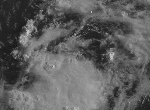
LarryWx wrote:This appears to be the closest buoy to 92L with it at 28.9N, 78.5W or 120 nm E of Cape Canaveral. So, perhaps WSW of 92L’s center: does this tell us anything?

Station 41010
NDBC
Location: 28.878N 78.467W
Date: Fri, 21 Jun 2024 04:30:00 UTC
Winds: ENE (70°) at 3.9 kt gusting to 5.8 kt
Atmospheric Pressure: 30.07 in
Air Temperature: 79.2 F
Dew Point: 75.6 F
Water Temperature: 80.6 F


It's likely too far away to get much info about 92L's structure; the storm is just too tiny for that. It does show that the sea-level humidity is high and the water is warm at that location, though I don't know how relevant that is
2 likes   
New Jersey, Rutgers '27
Irene 2011 | Sandy 2012 | Fay 2020 | Isaias 2020 | Ida 2021

Nuno
Category 2
Category 2
Posts: 591
Joined: Fri Aug 30, 2019 8:35 am
Location: Coral Gables, FL

Re: ATL: INVEST 92L - Discussion

#82 Postby Nuno » Fri Jun 21, 2024 12:09 am

I don't see why this can't be designated as a PTC at 5am. It's going to move over the gulf stream, low shear environment. Why not be better safe than sorry and get the word out tomorrow morning for a region that doesn't often experience strengthening (albeit weaker) cyclones often?
4 likes   
Andrew (1992), Irene (1999), Frances (2004), Katrina (2005), Wilma (2005), Fay (2008), Irma (2017), Eta (2020), Ian (2022)

User avatar
Blown Away
S2K Supporter
S2K Supporter
Posts: 10140
Joined: Wed May 26, 2004 6:17 am

Re: ATL: INVEST 92L - Discussion

#83 Postby Blown Away » Fri Jun 21, 2024 12:25 am

Image

PTC/TD/TS possible now IMO…
2 likes   
Hurricane Eye Experience: David 79, Irene 99, Frances 04, Jeanne 04, Wilma 05... EYE COMING MY WAY IN 2024…
Hurricane Brush Experience: Andrew 92, Erin 95, Floyd 99, Matthew 16, Irma 17, Ian 22, Nicole 22…

User avatar
chaser1
S2K Supporter
S2K Supporter
Posts: 5407
Age: 64
Joined: Sat Oct 15, 2005 5:59 pm
Location: Longwood, Fl

Re: ATL: INVEST 92L - Discussion

#84 Postby chaser1 » Fri Jun 21, 2024 12:37 am

I have to believe that everything that we are seeing must be entirely aloft. As impressive as 92L appears, NHC must have quite the level of confidence to have "not" issued a PTC. At this stage with the primary convective mass estimated to be near the coastline by daybreak, there is little point to issue Watches or Warnings. Maybe we'll all be surprised with a rapid warming of the convective feature and the entire satellite presentation simply going to crap. I'm in awe of the fact that even meso scale models simply do not see this as any kind of significant surface feature.

Maybe the saying is true. It may look like a duck but if it doesn't walk, squalk, or smell like a duck.... it's probably not a duck :P
1 likes   
Andy D

(For official information, please refer to the NHC and NWS products.)

User avatar
ElectricStorm
Category 5
Category 5
Posts: 5017
Age: 24
Joined: Tue Aug 13, 2019 11:23 pm
Location: Skiatook, OK / Norman, OK

Re: ATL: INVEST 92L - Discussion

#85 Postby ElectricStorm » Fri Jun 21, 2024 12:52 am

Looks better than I expected it to, I think the chances of a quick TD/TS before landfall are increasing. Interested to see what recon finds in the morning.
0 likes   
I am in no way a professional. Take what I say with a grain of salt as I could be totally wrong. Please refer to the NHC, NWS, or SPC for official information.

Boomer Sooner!

User avatar
Woofde
Category 1
Category 1
Posts: 475
Joined: Tue Jul 06, 2021 11:33 am

Re: RE: Re: ATL: INVEST 92L - Discussion

#86 Postby Woofde » Fri Jun 21, 2024 12:55 am

Blown Away wrote:Image

PTC/TD/TS possible now IMO…
It certainly has that TS look to it. It's hard to tell what's happening below at the surface, though. I guess we will see when recon arrives in the morning if 92L doesn't change/degrade by then.

We are starting to get into radar range now.Image
0 likes   

ChrisH-UK
Category 2
Category 2
Posts: 611
Joined: Sat May 29, 2021 8:22 am

Re: ATL: INVEST 92L - Discussion

#87 Postby ChrisH-UK » Fri Jun 21, 2024 2:48 am

92L looks to have a decent outflow aided by upper level winds, convection might be dropping a bit But it should be moving over the gulf stream soon and with the heat probably intensify a bit before landfall.

GOES-16 CIRA Snow/Cloud product - https://col.st/XLafW

Image
0 likes   

User avatar
Nimbus
Category 5
Category 5
Posts: 5274
Joined: Mon Jul 19, 2004 10:54 am

Re: ATL: INVEST 92L - Discussion

#88 Postby Nimbus » Fri Jun 21, 2024 5:12 am

Convection waned a little over the morning hours but the new burst blown west of center looks impressive.
Its a good training mission for recon.
0 likes   

jlauderdal
S2K Supporter
S2K Supporter
Posts: 7177
Joined: Wed May 19, 2004 5:46 am
Location: NE Fort Lauderdale
Contact:

Re: ATL: INVEST 92L - Discussion

#89 Postby jlauderdal » Fri Jun 21, 2024 5:24 am

Nimbus wrote:Convection waned a little over the morning hours but the new burst blown west of center looks impressive.
Its a good training mission for recon.

At least it's relatively close to Biloxi. Soon, we will be looking back at these weak systems and wishing for weak systems, getting some good mdr signals; the July lull might not be much this year.
0 likes   

User avatar
kevin
Category 5
Category 5
Posts: 2554
Age: 26
Joined: Wed Aug 28, 2019 4:35 am

Re: ATL: INVEST 92L - Discussion

#90 Postby kevin » Fri Jun 21, 2024 5:37 am

About 1.5 - 2 hours until recon gets there. 92L looks very healthy right now with consistent convection over the center. I expect recon to find a tiny TD/TS.
0 likes   

User avatar
GCANE
S2K Supporter
S2K Supporter
Posts: 11453
Joined: Mon Oct 22, 2007 8:03 am

Re: ATL: INVEST 92L - Discussion

#91 Postby GCANE » Fri Jun 21, 2024 5:43 am

Its sitting in 2500 CAPE air with a dryline right on the coast.
The dryline should fire up additional convection, but the minimal CAPE should limit tropical development.
0 likes   

BobHarlem
Category 5
Category 5
Posts: 2034
Joined: Thu Oct 20, 2005 6:11 pm

Re: ATL: INVEST 92L - Discussion

#92 Postby BobHarlem » Fri Jun 21, 2024 6:34 am

Recon is getting around in there now, there is decent convection on the south side. Looks like Daytona Beach north to Jacksonville is the area that's going to get most of "the stuff" from this one later today, but any coastal flooding/surge probably limited to Jacksonville/GA. Even then won't be much because this is Tiny B.
0 likes   

zzzh
Category 3
Category 3
Posts: 833
Joined: Thu Sep 02, 2021 1:13 pm

Re: ATL: INVEST 92L - Discussion

#93 Postby zzzh » Fri Jun 21, 2024 6:53 am

Recon found a well defined center. Winds are TD level.
0 likes   

User avatar
cycloneye
Admin
Admin
Posts: 143867
Age: 68
Joined: Thu Oct 10, 2002 10:54 am
Location: San Juan, Puerto Rico

Re: ATL: INVEST 92L - Discussion

#94 Postby cycloneye » Fri Jun 21, 2024 6:54 am

Southwestern Atlantic Ocean (AL92):
A small area of showers and thunderstorms persists with a low
pressure system located around 150 miles east-southeast of
Jacksonville, Florida. An Air Force Reserve aircraft is currently
investigating the system to determine if the low has a well-defined
surface circulation. Environmental conditions remain marginally
conducive for some additional development, and this system could
become a short-lived tropical depression as the low moves
west-northwestward at 10 to 15 mph. The system is expected to reach
the coast of northeastern Florida or Georgia by tonight, and
interests there should monitor its progress.
* Formation chance through 48 hours...medium...50 percent.
* Formation chance through 7 days...medium...50 percent.
0 likes   
Visit the Caribbean-Central America Weather Thread where you can find at first post web cams,radars
and observations from Caribbean basin members Click Here

User avatar
cycloneye
Admin
Admin
Posts: 143867
Age: 68
Joined: Thu Oct 10, 2002 10:54 am
Location: San Juan, Puerto Rico

Re: ATL: INVEST 92L - Discussion

#95 Postby cycloneye » Fri Jun 21, 2024 7:13 am

0 likes   
Visit the Caribbean-Central America Weather Thread where you can find at first post web cams,radars
and observations from Caribbean basin members Click Here

User avatar
NDG
S2K Supporter
S2K Supporter
Posts: 15445
Joined: Sun Jul 09, 2006 10:14 pm
Location: Orlando, FL

Re: ATL: INVEST 92L - Discussion

#96 Postby NDG » Fri Jun 21, 2024 7:17 am

Much better defined LLC this morning, most of the convection to the south & west of it.

Image
0 likes   

User avatar
kevin
Category 5
Category 5
Posts: 2554
Age: 26
Joined: Wed Aug 28, 2019 4:35 am

Re: ATL: INVEST 92L - Discussion

#97 Postby kevin » Fri Jun 21, 2024 7:43 am

Recon measured 37 kt SFMR as well as 37 kt Est. Sfc. Wind. Peak FL winds so far are 29 kt, but they were flying at the surface (500 ft above the surface so FL winds are basically the same as surface wind). The seem to be climbing again based on the last recon data.
1 likes   

User avatar
Hypercane_Kyle
Category 5
Category 5
Posts: 3344
Joined: Sat Mar 07, 2015 7:58 pm
Location: Cape Canaveral, FL

Re: ATL: INVEST 92L - Discussion

#98 Postby Hypercane_Kyle » Fri Jun 21, 2024 7:52 am

Recon seems to indicate to me that we have a TD. I wouldn't be surprised to see an upgrade at 11am, perhaps sooner considering FL impacts.
0 likes   
My posts are my own personal opinion, defer to the National Hurricane Center (NHC) and other NOAA products for decision making during hurricane season.

User avatar
GCANE
S2K Supporter
S2K Supporter
Posts: 11453
Joined: Mon Oct 22, 2007 8:03 am

Re: ATL: INVEST 92L - Discussion

#99 Postby GCANE » Fri Jun 21, 2024 7:56 am

CAPE has increased to 3000 with a decent updraft at the LLC (LI = -6)
Chances seem to be increasing for some moderate intensification, especially when it gets closer to the coast and interacts with the dryline.
1 likes   

User avatar
kevin
Category 5
Category 5
Posts: 2554
Age: 26
Joined: Wed Aug 28, 2019 4:35 am

Re: ATL: INVEST 92L - Discussion

#100 Postby kevin » Fri Jun 21, 2024 8:01 am

Already looks better than Arlene did last year imo.
0 likes   


Return to “2024”

Who is online

Users browsing this forum: No registered users and 33 guests