ATL: INVEST 93L - Discussion

Moderator: S2k Moderators

Message
Author
User avatar
cycloneye
Admin
Admin
Posts: 143863
Age: 68
Joined: Thu Oct 10, 2002 10:54 am
Location: San Juan, Puerto Rico

ATL: INVEST 93L - Discussion

#1 Postby cycloneye » Fri Jun 21, 2024 7:36 pm

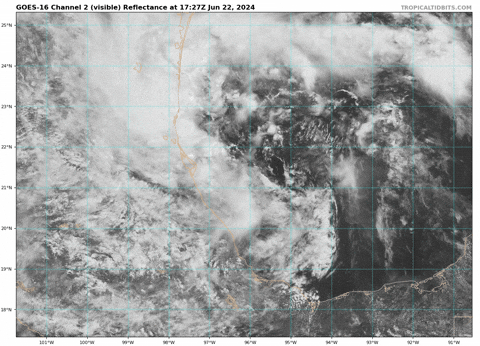
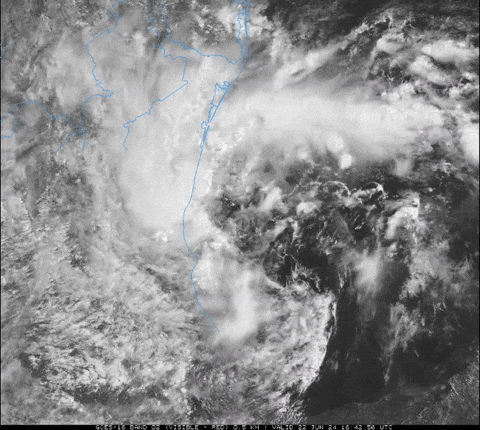
AL, 93, 2024062200, , BEST, 0, 195N, 935W, 25, 1005, DB


https://ftp.nhc.noaa.gov/atcf/btk/bal932024.dat

Image
0 likes   
Visit the Caribbean-Central America Weather Thread where you can find at first post web cams,radars
and observations from Caribbean basin members Click Here

User avatar
HurricaneBelle
S2K Supporter
S2K Supporter
Posts: 1169
Joined: Sun Aug 27, 2006 6:12 pm
Location: Clearwater, FL

Re: ATL: INVEST 93L - Discussion

#2 Postby HurricaneBelle » Fri Jun 21, 2024 7:51 pm

Alberto's daughter.
0 likes   

hipshot
Category 2
Category 2
Posts: 591
Joined: Tue Jul 06, 2010 9:18 pm
Location: Dallas, Texas

Re: ATL: INVEST 93L - Discussion

#3 Postby hipshot » Fri Jun 21, 2024 7:58 pm

HurricaneBelle wrote:Alberto's daughter.

I don't think I've seen this development before, I hope Mexico doesn't get hammered again!
0 likes   

User avatar
Category5Kaiju
Category 5
Category 5
Posts: 4051
Joined: Thu Dec 24, 2020 12:45 pm
Location: Seattle

Re: ATL: INVEST 93L - Discussion

#4 Postby Category5Kaiju » Fri Jun 21, 2024 8:01 pm

Bay of Campeche about to do its trick again :lol:
3 likes   
Unless explicitly stated, all info in my posts is based on my own opinions and observations. Tropical storms and hurricanes can be extremely dangerous. Do not think you can beat Mother Nature. Refer to an accredited weather research agency or meteorologist if you need to make serious decisions regarding an approaching storm.

Sciencerocks
Category 5
Category 5
Posts: 8903
Age: 39
Joined: Thu Jul 06, 2017 1:51 am

Re: ATL: INVEST 93L - Discussion

#5 Postby Sciencerocks » Fri Jun 21, 2024 8:47 pm

Image
2 likes   

User avatar
ElectricStorm
Category 5
Category 5
Posts: 5017
Age: 24
Joined: Tue Aug 13, 2019 11:23 pm
Location: Skiatook, OK / Norman, OK

Re: ATL: INVEST 93L - Discussion

#6 Postby ElectricStorm » Fri Jun 21, 2024 8:55 pm

I think if it develops it will be near the coast before landfall. Could see a 30-40kt system IMO
0 likes   
I am in no way a professional. Take what I say with a grain of salt as I could be totally wrong. Please refer to the NHC, NWS, or SPC for official information.

Boomer Sooner!

Sciencerocks
Category 5
Category 5
Posts: 8903
Age: 39
Joined: Thu Jul 06, 2017 1:51 am

Re: ATL: INVEST 93L - Discussion

#7 Postby Sciencerocks » Fri Jun 21, 2024 9:28 pm

This system appears to be somewhat more compact compared to alberto, but has a ull to the west moving into mexico that will induce southerly shear over the system over the next 24+ hours. Conditions won't be as favorable as alberto. Track appears to be to the west-northwest to northwest based on the models.

should have about 48-60 hours before landfall and I'd suggest a decent chance of a minimum tropical storm of 35-40 knts but only after 24-36 hours once it moves into the western portion of the boc. I agree you above as that is in fact the most likely outcome.
0 likes   

Astromanía
Category 2
Category 2
Posts: 767
Age: 26
Joined: Sat Aug 25, 2018 10:34 pm
Location: Monterrey, N.L, México

Re: ATL: INVEST 93L - Discussion

#8 Postby Astromanía » Fri Jun 21, 2024 10:58 pm

Due to it's smaller size I don't think I will receive the same amount of rain as Alberto unless it goes more to the north but I don't think that's going to happen
0 likes   

User avatar
tropicwatch
Category 5
Category 5
Posts: 3364
Age: 61
Joined: Sat Jun 02, 2007 10:01 am
Location: Panama City Florida
Contact:

Re: ATL: INVEST 93L - Discussion

#9 Postby tropicwatch » Fri Jun 21, 2024 11:18 pm

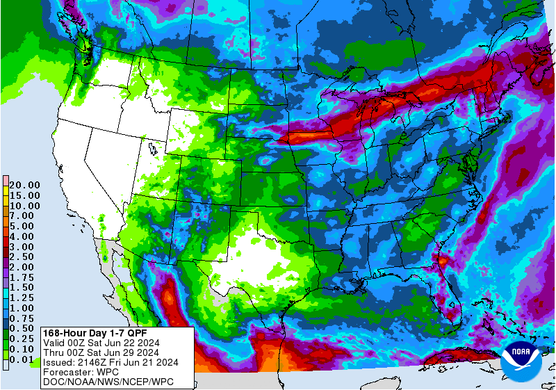
Astromanía wrote:Due to it's smaller size I don't think I will receive the same amount of rain as Alberto unless it goes more to the north but I don't think that's going to happen


Looking like most of the rain will remain in Mexico. Maybe not as much.

Image
0 likes   
Tropicwatch


Agnes 72', Eloise 75, Elena 85', Kate 85', Charley 86', Florence 88', Beryl 94', Dean 95', Erin 95', Opal 95', Earl 98', Georges 98', Ivan 2004', Arlene 2005', Dennis 2005', Ida 2009' Debby 2012' Irma 2017' Michael 2018'

Sciencerocks
Category 5
Category 5
Posts: 8903
Age: 39
Joined: Thu Jul 06, 2017 1:51 am

Re: ATL: INVEST 93L - Discussion

#10 Postby Sciencerocks » Sat Jun 22, 2024 12:42 am

Image
0 likes   

ChrisH-UK
Category 2
Category 2
Posts: 611
Joined: Sat May 29, 2021 8:22 am

Re: ATL: INVEST 93L - Discussion

#11 Postby ChrisH-UK » Sat Jun 22, 2024 6:10 am

93L looks a lot like what Alberto was, a lot of convection with the circulation. Once the sun has got up we should have a better view on 93L but i get the feeling we could have the next storm soon.

GOES-16 CIRA Snow/Cloud - https://col.st/r329j

Image
1 likes   

User avatar
cycloneye
Admin
Admin
Posts: 143863
Age: 68
Joined: Thu Oct 10, 2002 10:54 am
Location: San Juan, Puerto Rico

Re: ATL: INVEST 93L - Discussion

#12 Postby cycloneye » Sat Jun 22, 2024 6:50 am

8 AM.

Southwestern Gulf of Mexico (AL93):
A broad low pressure system located over the southwestern Gulf of
Mexico is producing a large area of disorganized showers and
thunderstorms. Environmental conditions appear conducive for
gradual development of this system as it moves slowly
west-northwestward or northwestward, and a tropical depression could
form before the system reaches the coast of northeastern Mexico
Sunday night. Regardless of development, heavy rainfall could
cause localized flooding across portions of northeastern Mexico and
Deep South Texas through the end of the weekend. An Air Force
Reserve reconnaissance aircraft is scheduled to investigate this
system later today, if necessary.
* Formation chance through 48 hours...medium...50 percent.
* Formation chance through 7 days...medium...50 percent.
0 likes   
Visit the Caribbean-Central America Weather Thread where you can find at first post web cams,radars
and observations from Caribbean basin members Click Here

User avatar
cycloneye
Admin
Admin
Posts: 143863
Age: 68
Joined: Thu Oct 10, 2002 10:54 am
Location: San Juan, Puerto Rico

Re: ATL: INVEST 93L - Discussion

#13 Postby cycloneye » Sat Jun 22, 2024 7:56 am

AL, 93, 2024062212, , BEST, 0, 210N, 957W, 30, 1005, DB


Image

Image
0 likes   
Visit the Caribbean-Central America Weather Thread where you can find at first post web cams,radars
and observations from Caribbean basin members Click Here

Sciencerocks
Category 5
Category 5
Posts: 8903
Age: 39
Joined: Thu Jul 06, 2017 1:51 am

Re: ATL: INVEST 93L - Discussion

#14 Postby Sciencerocks » Sat Jun 22, 2024 8:42 am

Image
0 likes   

User avatar
cycloneye
Admin
Admin
Posts: 143863
Age: 68
Joined: Thu Oct 10, 2002 10:54 am
Location: San Juan, Puerto Rico

Re: ATL: INVEST 93L - Discussion

#15 Postby cycloneye » Sat Jun 22, 2024 12:52 pm

2 PM. Down to 40%.

Southwestern Gulf of Mexico (AL93):
A broad low pressure system located over the southwestern Gulf of
Mexico is producing a large area of disorganized showers and
thunderstorms. Environmental conditions appear to have become a
little more marginal for development of this system as it moves
slowly northwestward, but a tropical depression could still form
before the system reaches the coast of northeastern Mexico
Sunday night. Regardless of development, heavy rainfall is likely
to cause localized flooding across portions of northeastern Mexico
and Deep South Texas through the end of the weekend. An Air Force
Reserve reconnaissance aircraft is currently investigating the
disturbance.
* Formation chance through 48 hours...medium...40 percent.
* Formation chance through 7 days...medium...40 percent.
0 likes   
Visit the Caribbean-Central America Weather Thread where you can find at first post web cams,radars
and observations from Caribbean basin members Click Here

User avatar
REDHurricane
Category 1
Category 1
Posts: 394
Age: 27
Joined: Sun Jul 03, 2022 2:36 pm
Location: Northeast Pacific Ocean

Re: ATL: INVEST 93L - Discussion

#16 Postby REDHurricane » Sat Jun 22, 2024 1:47 pm

LLC starting to form?

Image
0 likes   

User avatar
REDHurricane
Category 1
Category 1
Posts: 394
Age: 27
Joined: Sun Jul 03, 2022 2:36 pm
Location: Northeast Pacific Ocean

Re: ATL: INVEST 93L - Discussion

#17 Postby REDHurricane » Sat Jun 22, 2024 2:15 pm

It's definitely looking more interesting than it did a few hours ago, plus it seems to have found a nice little pocket of low wind shear for the time being. I wouldn't be surprised if the NHC raises the odds to at least 50% or 60% at the next outlook, especially given Alberto's relative overperformance.

Image

Image
2 likes   

User avatar
Hurricane2022
Category 5
Category 5
Posts: 1496
Joined: Tue Aug 23, 2022 11:38 pm
Location: Araçatuba, Brazil

Re: ATL: INVEST 93L - Discussion

#18 Postby Hurricane2022 » Sat Jun 22, 2024 2:36 pm

1 likes   
Sorry for the bad English sometimes...!
For reliable and detailed information for any meteorological phenomenon, please consult the National Hurricane Center, Joint Typhoon Warning Center , or your local Meteo Center.

--------

Una cvm Christo, pro Christo, et in Christo. Sit nomen Domini benedictvm.

User avatar
Hurricane2022
Category 5
Category 5
Posts: 1496
Joined: Tue Aug 23, 2022 11:38 pm
Location: Araçatuba, Brazil

Re: ATL: INVEST 93L - Discussion

#19 Postby Hurricane2022 » Sat Jun 22, 2024 2:37 pm

93L INVEST 240622 1800 21.6N 95.7W ATL 35 1006
0 likes   
Sorry for the bad English sometimes...!
For reliable and detailed information for any meteorological phenomenon, please consult the National Hurricane Center, Joint Typhoon Warning Center , or your local Meteo Center.

--------

Una cvm Christo, pro Christo, et in Christo. Sit nomen Domini benedictvm.

IsabelaWeather
Category 1
Category 1
Posts: 287
Age: 35
Joined: Tue Jul 07, 2020 7:29 am
Location: Isabela, Puerto Rico

Re: ATL: INVEST 93L - Discussion

#20 Postby IsabelaWeather » Sat Jun 22, 2024 2:42 pm

No chance this gets named. No convection near the center, this thing looks like crap and doesnt have much more time over water.
0 likes   


Return to “2024”

Who is online

Users browsing this forum: No registered users and 9 guests