
ATL: INVEST 92L - Discussion
Moderator: S2k Moderators
-
Sciencerocks
- Category 5

- Posts: 10193
- Age: 40
- Joined: Thu Jul 06, 2017 1:51 am
-
cycloneye

- Admin

- Posts: 149695
- Age: 69
- Joined: Thu Oct 10, 2002 10:54 am
- Location: San Juan, Puerto Rico
Re: ATL: INVEST 92L - Discussion
Moving slower this morning and there is a flareup of convection offshore.

2 likes
Visit the Caribbean-Central America Weather Thread where you can find at first post web cams,radars
and observations from Caribbean basin members Click Here
and observations from Caribbean basin members Click Here
-
cycloneye
- Admin
- Posts: 149695
- Age: 69
- Joined: Thu Oct 10, 2002 10:54 am
- Location: San Juan, Puerto Rico
Re: ATL: INVEST 92L - Discussion
8 AM.
Near the Georgia Coast (AL92):
A low pressure system centered inland over southeastern Georgia is
producing disorganized showers and thunderstorms, mainly over the
coastal waters off of northeastern Florida and Georgia. The low
is expected to drift slowly northwestward or northward today before
dissipating tonight. Tropical cyclone formation is not expected.
* Formation chance through 48 hours...low...near 0 percent.
* Formation chance through 7 days...low...near 0 percent.
0 likes
Visit the Caribbean-Central America Weather Thread where you can find at first post web cams,radars
and observations from Caribbean basin members Click Here
and observations from Caribbean basin members Click Here
-
tropicwatch

- Category 5
- Posts: 3427
- Age: 62
- Joined: Sat Jun 02, 2007 10:01 am
- Location: The Villages, Florida
- Contact:
Re: ATL: INVEST 92L - Discussion
Looks to be sitting right along the coastline and convection is really pumping up this morning. Soggy day coming for the Georgia coastline.
1 likes
Tropicwatch
Agnes 72', Eloise 75, Elena 85', Kate 85', Charley 86', Florence 88', Beryl 94', Dean 95', Erin 95', Opal 95', Earl 98', Georges 98', Ivan 2004', Arlene 2005', Dennis 2005', Ida 2009' Debby 2012' Irma 2017' Michael 2018'
Agnes 72', Eloise 75, Elena 85', Kate 85', Charley 86', Florence 88', Beryl 94', Dean 95', Erin 95', Opal 95', Earl 98', Georges 98', Ivan 2004', Arlene 2005', Dennis 2005', Ida 2009' Debby 2012' Irma 2017' Michael 2018'
Re: ATL: INVEST 92L - Discussion
92L sitting on the coast might not be dead yet. Interestingly the CMC model had it stall on the coast before heading north east back out to sea.

3 likes
-
Sciencerocks
- Category 5
- Posts: 10193
- Age: 40
- Joined: Thu Jul 06, 2017 1:51 am


Re: ATL: INVEST 92L - Discussion
ChrisH-UK wrote:92L sitting on the coast might not be dead yet. Interestingly the CMC model had it stall on the coast before heading north east back out to sea.
https://imagizer.imageshack.com/img923/5183/PrmKWn.gif
Surface SLPs have risen slightly at Sapelo Is/SSI/Brunswick from 1015 to 1016-17 last few hours. So, nothing of consequence going on at sfc.
0 likes
Personal Forecast Disclaimer:
The posts in this forum are NOT official forecasts and should not be used as such. They are just the opinion of the poster and may or may not be backed by sound meteorological data. They are NOT endorsed by any professional institution or storm2k.org. For official information, please refer to the NHC and NWS products.
The posts in this forum are NOT official forecasts and should not be used as such. They are just the opinion of the poster and may or may not be backed by sound meteorological data. They are NOT endorsed by any professional institution or storm2k.org. For official information, please refer to the NHC and NWS products.
-
CyclonicFury

- Category 5
- Posts: 2038
- Age: 27
- Joined: Sun Jul 02, 2017 12:32 pm
- Location: NC
- Contact:
Re: ATL: INVEST 92L - Discussion
LarryWx wrote:ChrisH-UK wrote:92L sitting on the coast might not be dead yet. Interestingly the CMC model had it stall on the coast before heading north east back out to sea.
https://imagizer.imageshack.com/img923/5183/PrmKWn.gif
Surface SLPs have risen slightly at Sapelo Is/SSI/Brunswick from 1015 to 1016-17 last few hours. So, nothing of consequence going on at sfc.
The circulation still looks very visible on satellite imagery, and surface observations confirm it is still well-defined. The high surface pressures are to be expected since 92L is in a high MSLP environment. A case can be made that 92L was a tropical depression in post-analysis, though I think the collapse in convection yesterday afternoon will prevent a post-season designation.
2 likes
NCSU B.S. in Meteorology Class of 2021. Tropical weather blogger at http://www.cyclonicfury.com. My forecasts and thoughts are NOT official, for official forecasts please consult the National Hurricane Center.
Re: ATL: INVEST 92L - Discussion
CyclonicFury wrote:LarryWx wrote:ChrisH-UK wrote:92L sitting on the coast might not be dead yet. Interestingly the CMC model had it stall on the coast before heading north east back out to sea.
https://imagizer.imageshack.com/img923/5183/PrmKWn.gif
Surface SLPs have risen slightly at Sapelo Is/SSI/Brunswick from 1015 to 1016-17 last few hours. So, nothing of consequence going on at sfc.
The circulation still looks very visible on satellite imagery, and surface observations confirm it is still well-defined. The high surface pressures are to be expected since 92L is in a high MSLP environment. A case can be made that 92L was a tropical depression in post-analysis, though I think the collapse in convection yesterday afternoon will prevent a post-season designation.
I realize there’s still a fairly well defined weak low within a pretty high SLP background. I’m just saying not much is changing as far as the strength of the low is concerned. It appears to still be barely onshore drifting slowly N.
Edit: I’ve had ~1/3” of rain the last ~12 hrs here in the SAV area from several feeder bands. Skies are overcast with E winds of 15 here on the N side of the circ, which appears to be centered ~50 mi SSW of me in ~N McIntosh Cty. To the S of the LLC, Brunswick area has SW-15 winds.
Last edited by LarryWx on Sat Jun 22, 2024 11:25 am, edited 1 time in total.
0 likes
Personal Forecast Disclaimer:
The posts in this forum are NOT official forecasts and should not be used as such. They are just the opinion of the poster and may or may not be backed by sound meteorological data. They are NOT endorsed by any professional institution or storm2k.org. For official information, please refer to the NHC and NWS products.
The posts in this forum are NOT official forecasts and should not be used as such. They are just the opinion of the poster and may or may not be backed by sound meteorological data. They are NOT endorsed by any professional institution or storm2k.org. For official information, please refer to the NHC and NWS products.
-
skyline385

- Category 5
- Posts: 2728
- Age: 35
- Joined: Wed Aug 26, 2020 11:15 pm
- Location: Houston TX
Re: ATL: INVEST 92L - Discussion
Almost all of the rain (8"+ in some locations) is offshore for now, lets hope it stays that way. Hazards are being handled by the NWS for now.
1 likes
Re: ATL: INVEST 92L - Discussion
skyline385 wrote:Almost all of the rain (8"+ in some locations) is offshore for now, lets hope it stays that way. Hazards are being handled by the NWS for now.
https://i.postimg.cc/gk0nHct5/1.png
As the LLC has gotten closer to here, the winds have increased to 15 with gusts to 20 and shifted from E to ESE.
If you go to this link and animate it, you can clearly see the slowly N moving LLC centered onshore about midway between SAV and SSI: check out all of the little heat induced pop up showers (cool stuff):
https://weather.cod.edu/satrad/nexrad/? ... 00-usa-rad
0 likes
Personal Forecast Disclaimer:
The posts in this forum are NOT official forecasts and should not be used as such. They are just the opinion of the poster and may or may not be backed by sound meteorological data. They are NOT endorsed by any professional institution or storm2k.org. For official information, please refer to the NHC and NWS products.
The posts in this forum are NOT official forecasts and should not be used as such. They are just the opinion of the poster and may or may not be backed by sound meteorological data. They are NOT endorsed by any professional institution or storm2k.org. For official information, please refer to the NHC and NWS products.

Re: ATL: INVEST 92L - Discussion
Ubuntwo wrote:jr0d wrote:Clearly the NHC did not see strong enough evidence of sustained 35kt winds and I would even say giving this little swirl credit for sustained winds of 25kts would be generous, hence why it is not classified depression or PTC.
The NHC established in the TWO that there is sufficient evidence of 30kt winds and a closed circulation. It is the lack of convective organization preventing a TD designation.
Again this was NOT evidence of sustained 30kt winds, likely gusty winds in a short lived squall and I understand why the NHC did not upgrade based on that information.
I was looking at the Surfline cams and reports yesterday and nowhere saw surf above 6 feet, so as I posted before the erosion threat was minimal at best. Today the surf around Georgia and South Carolina is in the 3 foot or less range.
Last edited by Jr0d on Sat Jun 22, 2024 1:05 pm, edited 1 time in total.
0 likes
-
TallyTracker
- Category 2

- Posts: 787
- Joined: Thu Oct 11, 2018 2:46 pm
Re: ATL: INVEST 92L - Discussion
Looking back at this invest over the past two days, I think not designating was the right call. The convection was never more than pulsing. I don’t think it fully met the definition of a tropical cyclone.
Also, being so close to land with little development potential, it would have caused a lot of excitement for nothing. I think the NHC made the right call from a science and public safety perspective. I don’t foresee a post-season designation from this.
Also, being so close to land with little development potential, it would have caused a lot of excitement for nothing. I think the NHC made the right call from a science and public safety perspective. I don’t foresee a post-season designation from this.
3 likes
Fran '96, Georges '98, Gordon '00, Gabrielle '01, Charley '04, Frances '04, Jeanne '04, Barry '07, Fay '08, Debby '12, Matthew '16, Emily '17, Irma '17, Michael ‘18, Elsa ‘21, Fred ‘21, Mindy ‘21, Nicole ‘22, Idalia ‘23, Debby ‘24, Helene ‘24
-
cycloneye
- Admin
- Posts: 149695
- Age: 69
- Joined: Thu Oct 10, 2002 10:54 am
- Location: San Juan, Puerto Rico
Re: ATL: INVEST 92L - Discussion
2 PM.
Near the Georgia Coast (AL92):
Showers and thunderstorms associated with a low pressure system
centered just inland over southeastern Georgia have decreased
during the past several hours. The low is expected to drift slowly
north-northeastward near the coasts of Georgia and southern South
Carolina through tonight before dissipating by Sunday. Tropical
cyclone formation is not expected.
* Formation chance through 48 hours...low...near 0 percent.
* Formation chance through 7 days...low...near 0 percent.
0 likes
Visit the Caribbean-Central America Weather Thread where you can find at first post web cams,radars
and observations from Caribbean basin members Click Here
and observations from Caribbean basin members Click Here
-
HippyFarmGirl
- Tropical Wave

- Posts: 3
- Age: 55
- Joined: Wed Aug 17, 2022 7:17 am
Re: ATL: INVEST 92L - Discussion
I was really hoping to see an uptick in the rain forecast for North Florida along the Gulf side from this. Alas, still dry and crunchy as ever in Chiefland.
0 likes
The wall flower with a few South Florida storms under her belt.

Re: ATL: INVEST 92L - Discussion
TallyTracker wrote:Looking back at this invest over the past two days, I think not designating was the right call. The convection was never more than pulsing. I don’t think it fully met the definition of a tropical cyclone.
Also, being so close to land with little development potential, it would have caused a lot of excitement for nothing. I think the NHC made the right call from a science and public safety perspective. I don’t foresee a post-season designation from this.
To my knowledge they won't do this with tropical depressions regardless
1 likes
The above post is not official and should not be used as such. It is the opinion of the poster and may or may not be backed by sound meteorological data. It is not endorsed by any professional institution or storm2k.org. For official information, please refer to the NHC and NWS products.
-
skyline385
- Category 5
- Posts: 2728
- Age: 35
- Joined: Wed Aug 26, 2020 11:15 pm
- Location: Houston TX
Re: ATL: INVEST 92L - Discussion
Good thread and discussion about what goes in their minds especially hazards influencing the subjective nature of it
https://x.com/EricBlake12/status/1804289528686952755
https://x.com/FranklinJamesL/status/1804247618383430080
https://x.com/EricBlake12/status/1804289528686952755
https://x.com/FranklinJamesL/status/1804247618383430080
2 likes
-
NXStumpy_Robothing
- Category 1

- Posts: 335
- Age: 25
- Joined: Fri Jun 05, 2020 11:50 pm
- Location: North Georgia
Re: ATL: INVEST 92L - Discussion
I'd just appreciate some consistency over naming/designation standards at this point, and/or at the very least, a semi-public checklist instead of the subjective view we have on TCs now. I can think of many similar cases where if a storm and 92L had been switched the upgrade to TD/TS would've been made (and vice versa). I don't necessarily mind it not being upgraded (even though I'm in the camp of it being a TS and a decaying TD at landfall) but casts a bit of a shadow of a doubt on the name storm count climatology if we're going to make these sort of judgment calls every time.
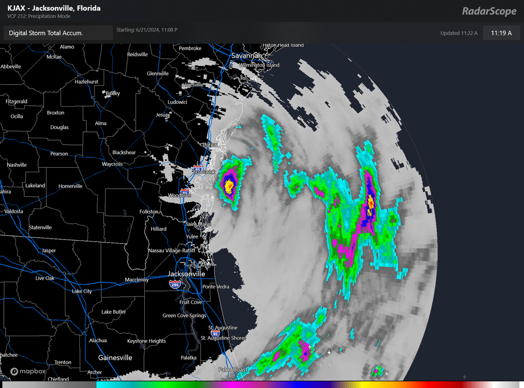
Definitely still generating convection and has been doing so for the past 36-42 hours, fwiw. Brunswick/Jacksonville have had multiple bands go through their areas today. Nothing too extreme, but interesting to note for any potential TCR nonetheless.
Definitely still generating convection and has been doing so for the past 36-42 hours, fwiw. Brunswick/Jacksonville have had multiple bands go through their areas today. Nothing too extreme, but interesting to note for any potential TCR nonetheless.
Last edited by NXStumpy_Robothing on Mon Jun 24, 2024 2:16 pm, edited 1 time in total.
4 likes
Undergraduate Meteorology Student, Georgia Institute of Technology
-
Sciencerocks
- Category 5
- Posts: 10193
- Age: 40
- Joined: Thu Jul 06, 2017 1:51 am
Re: ATL: INVEST 92L - Discussion
Plenty of systems that acted like this one have been named and sometimes 2-3 per season. Also lets be honest,,,,This had more then enough convection for 6-12 hour period. So I guess a ton of systems wouldn't have been deserving of being named unless it sustains convection for days straight. That doesn't make sense to me.
4 likes
Re: ATL: Ex INVEST 92L - Discussion
For the first time since 92L started affecting this area, we’re getting thunderstorms. The rainfall is quite heavy and is training within a band moving NNW from the ocean. There are no warnings yet out for this county, but very likely this has already caused street flooding.
Edit: I ended up with a little over 2” during ~2 hour period with most of that falling within an hour.
As of 10AM Sunday 6/23: LLC now over SE SC (near Beaufort)
Edit: I ended up with a little over 2” during ~2 hour period with most of that falling within an hour.
As of 10AM Sunday 6/23: LLC now over SE SC (near Beaufort)
0 likes
Personal Forecast Disclaimer:
The posts in this forum are NOT official forecasts and should not be used as such. They are just the opinion of the poster and may or may not be backed by sound meteorological data. They are NOT endorsed by any professional institution or storm2k.org. For official information, please refer to the NHC and NWS products.
The posts in this forum are NOT official forecasts and should not be used as such. They are just the opinion of the poster and may or may not be backed by sound meteorological data. They are NOT endorsed by any professional institution or storm2k.org. For official information, please refer to the NHC and NWS products.
Who is online
Users browsing this forum: No registered users and 88 guests