2024 Global Model Runs Discussion (Out thru day 16)
Moderator: S2k Moderators
Forum rules

The posts in this forum are NOT official forecasts and should not be used as such. They are just the opinion of the poster and may or may not be backed by sound meteorological data. They are NOT endorsed by any professional institution or STORM2K. For official information, please refer to products from the National Hurricane Center and National Weather Service.
-
skyline385

- Category 5

- Posts: 2728
- Age: 35
- Joined: Wed Aug 26, 2020 11:15 pm
- Location: Houston TX
Re: 2024 Global Model Runs Discussion (Out thru day 16)
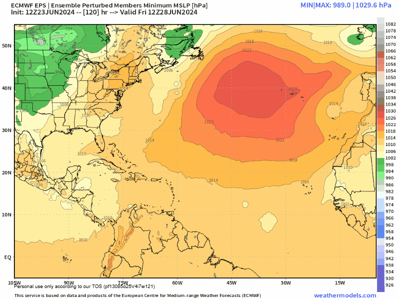
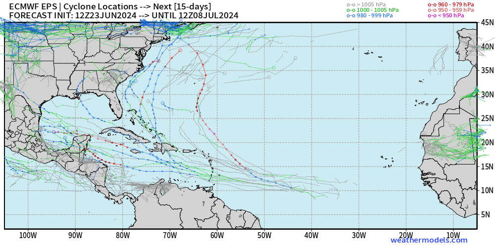
EPS continuing to remain decently activity going into early July
3 likes
-
MEANINGLESS_NUMBERS
- Category 2

- Posts: 503
- Joined: Mon Nov 02, 2020 1:43 pm
Re: 2024 Global Model Runs Discussion (Out thru day 16)
skyline385 wrote:EPS continuing to remain decently activity going into early July
[url]https://i.postimg.cc/ZRHrSR16/14-km-EPS-Global-Cyclones-Tropical-Atlantic-Ens-Minimum-MSLP.gif [/url]
That big signal over Bermuda
0 likes
Emily '87, Felix '95, Gert '99, Fabian '03, Humberto '19, Paulette '20, Teddy '20, Fiona '22, Lee '23, Ernesto '24, Humberto/Imelda '25
-
skyline385
- Category 5
- Posts: 2728
- Age: 35
- Joined: Wed Aug 26, 2020 11:15 pm
- Location: Houston TX
Re: 2024 Global Model Runs Discussion (Out thru day 16)
skyline385 wrote:EPS continuing to remain decently activity going into early July
[url]https://i.postimg.cc/ZRHrSR16/14-km-EPS-Global-Cyclones-Tropical-Atlantic-Ens-Minimum-MSLP.gif [/url]
2 likes
-
Category5Kaiju

- Category 5
- Posts: 4330
- Joined: Thu Dec 24, 2020 12:45 pm
- Location: Seattle and Phoenix
Re: 2024 Global Model Runs Discussion (Out thru day 16)
skyline385 wrote:skyline385 wrote:EPS continuing to remain decently activity going into early July
[url]https://i.postimg.cc/ZRHrSR16/14-km-EPS-Global-Cyclones-Tropical-Atlantic-Ens-Minimum-MSLP.gif [/url]
[url]https://i.postimg.cc/PqRWG3s1/eps-cyclones-atlantic-360.png [/url]
Wow, that's a lot of pretty robust MDR-born systems
Again, under normal circumstances I probably would brush them off, especially this early in the calendar year, but then again, the conditions we seem to have for this season seem to be setting up to be very favorable, so who knows?
1 likes
Unless explicitly stated, all info in my posts is based on my own opinions and observations. Tropical storms and hurricanes can be extremely dangerous. Refer to an accredited weather research agency or meteorologist if you need to make serious decisions regarding an approaching storm.
-
AnnularCane

- S2K Supporter

- Posts: 2957
- Joined: Thu Jun 08, 2006 9:18 am
- Location: Wytheville, VA
Re: 2024 Global Model Runs Discussion (Out thru day 16)
skyline385 wrote:EPS continuing to remain decently activity going into early July
[url]https://i.postimg.cc/ZRHrSR16/14-km-EPS-Global-Cyclones-Tropical-Atlantic-Ens-Minimum-MSLP.gif [/url]
I like the one that seems to just blow up over the Carolinas.
0 likes
"But it never rained rain. It never snowed snow. And it never blew just wind. It rained things like soup and juice. It snowed mashed potatoes and green peas. And sometimes the wind blew in storms of hamburgers." -- Judi Barrett, Cloudy with a Chance of Meatballs
Re: 2024 Global Model Runs Discussion (Out thru day 16)
0Z UKMET has a TS that forms on Thur 150 miles W of Bermuda moving NE: (2nd run in a row with something similar):
NEW TROPICAL CYCLONE FORECAST TO DEVELOP AFTER 84 HOURS
FORECAST POSITION AT T+ 84 : 32.9N 67.1W
LEAD CENTRAL MAXIMUM WIND
VERIFYING TIME TIME POSITION PRESSURE (MB) SPEED (KNOTS)
-------------- ---- -------- ------------- -------------
1200UTC 27.06.2024 84 32.9N 67.1W 1008 40
0000UTC 28.06.2024 96 35.9N 64.5W 1006 35
1200UTC 28.06.2024 108 38.9N 60.7W 1002 38
0000UTC 29.06.2024 120 44.4N 55.1W 1001 41
1200UTC 29.06.2024 132 50.5N 49.5W 991 42
0000UTC 30.06.2024 144 POST-TROPICAL
0 likes
Personal Forecast Disclaimer:
The posts in this forum are NOT official forecasts and should not be used as such. They are just the opinion of the poster and may or may not be backed by sound meteorological data. They are NOT endorsed by any professional institution or storm2k.org. For official information, please refer to the NHC and NWS products.
The posts in this forum are NOT official forecasts and should not be used as such. They are just the opinion of the poster and may or may not be backed by sound meteorological data. They are NOT endorsed by any professional institution or storm2k.org. For official information, please refer to the NHC and NWS products.
-
MEANINGLESS_NUMBERS
- Category 2
- Posts: 503
- Joined: Mon Nov 02, 2020 1:43 pm
Re: 2024 Global Model Runs Discussion (Out thru day 16)
LarryWx wrote:0Z UKMET has a TS that forms on Thur 150 miles W of Bermuda moving NE: (2nd run in a row with something similar):
NEW TROPICAL CYCLONE FORECAST TO DEVELOP AFTER 84 HOURS
FORECAST POSITION AT T+ 84 : 32.9N 67.1W
LEAD CENTRAL MAXIMUM WIND
VERIFYING TIME TIME POSITION PRESSURE (MB) SPEED (KNOTS)
-------------- ---- -------- ------------- -------------
1200UTC 27.06.2024 84 32.9N 67.1W 1008 40
0000UTC 28.06.2024 96 35.9N 64.5W 1006 35
1200UTC 28.06.2024 108 38.9N 60.7W 1002 38
0000UTC 29.06.2024 120 44.4N 55.1W 1001 41
1200UTC 29.06.2024 132 50.5N 49.5W 991 42
0000UTC 30.06.2024 144 POST-TROPICAL
No signal in the other models though. This would be an unusual time of year for Bermuda to see some action although when we do it does tend to be pinching off fronts rather than recurving MDR/Caribbean systems.
1 likes
Emily '87, Felix '95, Gert '99, Fabian '03, Humberto '19, Paulette '20, Teddy '20, Fiona '22, Lee '23, Ernesto '24, Humberto/Imelda '25

Re: 2024 Global Model Runs Discussion (Out thru day 16)
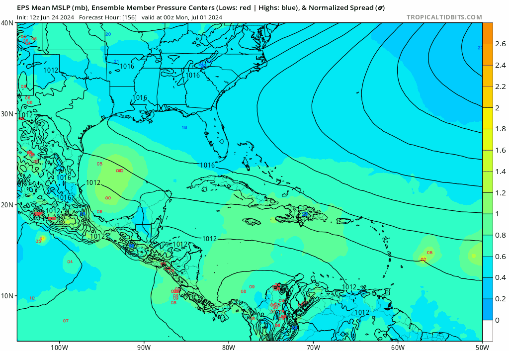
The same ensembles which show possible development out the TWs tracking across the Atlantic into the Caribbean over the next 10 days or so show a protective ridge across the southern US if not through the next 16 days.

1 likes
-
LearnedHat
- Tropical Depression

- Posts: 96
- Joined: Wed Feb 10, 2010 11:17 am
- Location: Keller, TX
Re: 2024 Global Model Runs Discussion (Out thru day 16)
NDG wrote:The same ensembles which show possible development out the TWs tracking across the Atlantic into the Caribbean over the next 10 days or so show a protective ridge across the southern US if not through the next 16 days.
https://i.imgur.com/gnLQdvL.png
Does this leave the Texas / Mexico border as a possibility or is that shielded as well.
0 likes
Re: 2024 Global Model Runs Discussion (Out thru day 16)
LearnedHat wrote:NDG wrote:The same ensembles which show possible development out the TWs tracking across the Atlantic into the Caribbean over the next 10 days or so show a protective ridge across the southern US if not through the next 16 days.
https://i.imgur.com/gnLQdvL.png
Does this leave the Texas / Mexico border as a possibility or is that shielded as well.
It depends, many other factors could come into play, strength of tropical system and at what latitude it would enter the GOM.
0 likes
-
weeniepatrol

- Category 5
- Posts: 1341
- Joined: Sat Aug 22, 2020 5:30 pm
- Location: WA State

-
jlauderdal
- S2K Supporter
- Posts: 7240
- Joined: Wed May 19, 2004 5:46 am
- Location: NE Fort Lauderdale
- Contact:
Re: RE: Re: 2024 Global Model Runs Discussion (Out thru day 16)
With the gfs on deck, the infamous happy hour gfsweeniepatrol wrote:Wakey wakey, weenies!
0 likes
-
AnnularCane
- S2K Supporter
- Posts: 2957
- Joined: Thu Jun 08, 2006 9:18 am
- Location: Wytheville, VA
Re: 2024 Global Model Runs Discussion (Out thru day 16)
jlauderdal wrote:With the gfs on deck, the infamous happy hour gfs
Isn't happy hour 18z, or did that change?
0 likes
"But it never rained rain. It never snowed snow. And it never blew just wind. It rained things like soup and juice. It snowed mashed potatoes and green peas. And sometimes the wind blew in storms of hamburgers." -- Judi Barrett, Cloudy with a Chance of Meatballs
-
jlauderdal
- S2K Supporter
- Posts: 7240
- Joined: Wed May 19, 2004 5:46 am
- Location: NE Fort Lauderdale
- Contact:
Re: 2024 Global Model Runs Discussion (Out thru day 16)
Still the same time 18z.AnnularCane wrote:jlauderdal wrote:With the gfs on deck, the infamous happy hour gfs
Isn't happy hour 18z, or did that change?
0 likes
-
skyline385
- Category 5
- Posts: 2728
- Age: 35
- Joined: Wed Aug 26, 2020 11:15 pm
- Location: Houston TX
Re: 2024 Global Model Runs Discussion (Out thru day 16)
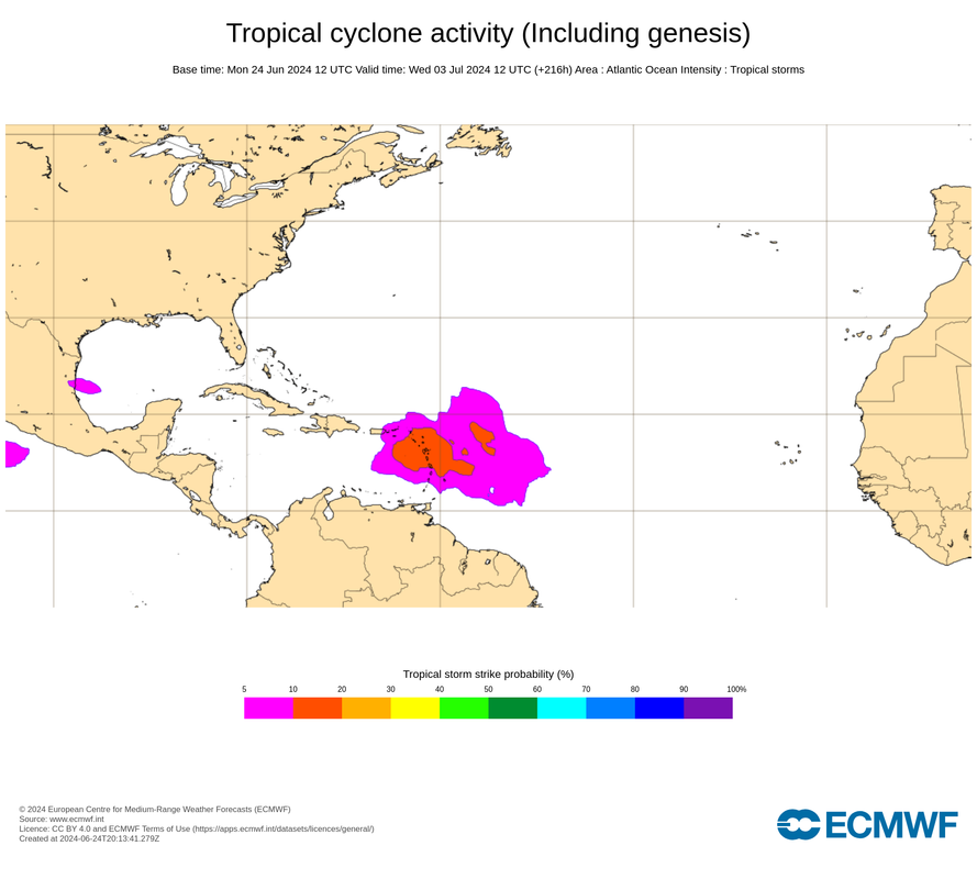
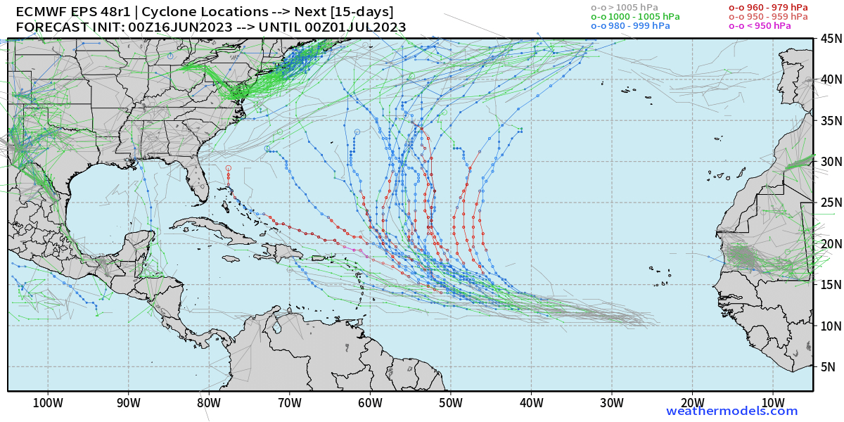
Just bear in mind that the weathernerds EPS cyclone plot shows almost all members regardless of level of development and can sometimes be misleading. 12z EPS has a 10-20% chance of a TS which is reasonable but nothing insane like the weathernerds plot would suggest. And remember this is EPS 48r1 (released last year) which is much more aggressive than the old 47r3 EPS after its resolution was increased to 8-km (along with other updates). See below for what it famously had in June last year for Bret. All I am saying is keep expectations in check for early-July
Chances of current interest on 12z EPS:
Bret 2023 on 48r1 EPS:
0 likes
-
Blown Away

- S2K Supporter
- Posts: 10253
- Joined: Wed May 26, 2004 6:17 am
Re: 2024 Global Model Runs Discussion (Out thru day 16)
12z Euro…
1 likes
Hurricane Eye Experience: David 79, Irene 99, Frances 04, Jeanne 04, Wilma 05… Hurricane Brush Experience: Andrew 92, Erin 95, Floyd 99, Matthew 16, Irma 17, Ian 22, Nicole 22…
-
jlauderdal
- S2K Supporter
- Posts: 7240
- Joined: Wed May 19, 2004 5:46 am
- Location: NE Fort Lauderdale
- Contact:
Re: 2024 Global Model Runs Discussion (Out thru day 16)
Well established escape route.Blown Away wrote:
12z Euro…
1 likes
-
Blown Away
- S2K Supporter
- Posts: 10253
- Joined: Wed May 26, 2004 6:17 am
Re: 2024 Global Model Runs Discussion (Out thru day 16)
jlauderdal wrote:Well established escape route.
12z EPS
0 likes
Hurricane Eye Experience: David 79, Irene 99, Frances 04, Jeanne 04, Wilma 05… Hurricane Brush Experience: Andrew 92, Erin 95, Floyd 99, Matthew 16, Irma 17, Ian 22, Nicole 22…
-
ElectricStorm

- Category 5
- Posts: 5139
- Age: 25
- Joined: Tue Aug 13, 2019 11:23 pm
- Location: Norman, OK
Re: 2024 Global Model Runs Discussion (Out thru day 16)
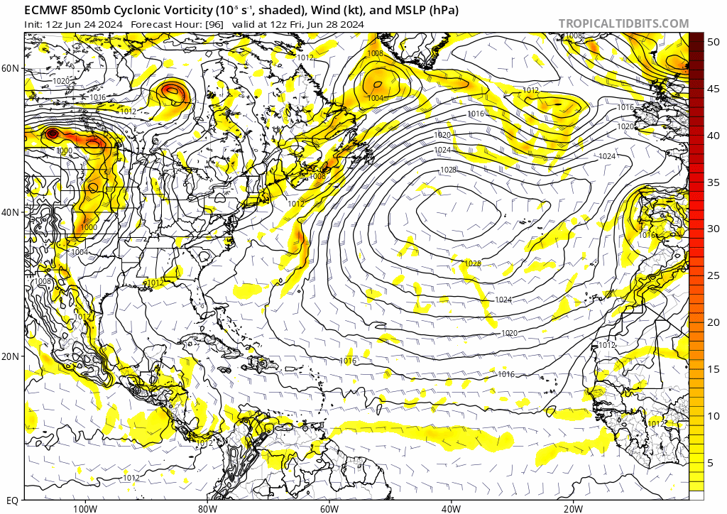
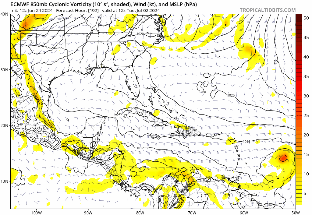
0z GFS tries to develop two MDR waves, the first one is directly south of Cabo Verde at the start of the run. Here it is at hour 144:

Second wave at hour 198 east of the islands:

Second wave at hour 198 east of the islands:
1 likes
B.S Meteorology, University of Oklahoma '25
Please refer to the NHC, NWS, or SPC for official information.
Please refer to the NHC, NWS, or SPC for official information.
Who is online
Users browsing this forum: Google [Bot], ljmac75 and 241 guests