Waves at 6/18/24 on 06z analysis.
The axis of an eastern Atlantic tropical wave is near 32W/33W,
south of 16N, moving westward at 10-15 knots. Only limited
convection is noted near the trough axis.
The axis of an eastern Caribbean tropical wave is near 66W, south
of 17N, moving westward at 10-15 knots. No deep convection is
noted near the trough axis.
2024 Tropical Waves
Moderator: S2k Moderators
Forum rules

The posts in this forum are NOT official forecasts and should not be used as such. They are just the opinion of the poster and may or may not be backed by sound meteorological data. They are NOT endorsed by any professional institution or STORM2K. For official information, please refer to products from the National Hurricane Center and National Weather Service.
-
cycloneye

- Admin

- Posts: 149703
- Age: 69
- Joined: Thu Oct 10, 2002 10:54 am
- Location: San Juan, Puerto Rico
Re: 2024 Tropical Waves
0 likes
Visit the Caribbean-Central America Weather Thread where you can find at first post web cams,radars
and observations from Caribbean basin members Click Here
and observations from Caribbean basin members Click Here
-
cycloneye
- Admin
- Posts: 149703
- Age: 69
- Joined: Thu Oct 10, 2002 10:54 am
- Location: San Juan, Puerto Rico
Re: 2024 Tropical Waves
Waves at 6/19/24 on 06z analysis.
The axis of an eastern Atlantic tropical wave is near 21W from
02N to 19N. The wave is moving westward at around 10 to 15 kt.
Scattered moderate convection is within 210 nm east of the wave
axis.
The axis of a central Atlantic tropical wave is near 37W from 03N
to 17N, moving westward at around 15 kt. Any nearby convection is
discussed in the monsoon trough/ITCZ section.
The axis of an Atlantic tropical wave is near 53W south of 16N,
moving westward at 10 to 15 kt. This wave originated in the
midlatitudes and moved southward to become embedded within the
tradewind easterlies. As typical for these tropical waves that
originate in the midlatitudes, it is embedded within dry air so
there is no significant convection noted at this time.
The axis of a central Caribbean tropical wave is near 72W south
of 19N moving westward at 5 to 10 kt. No significant convection is
noted over the Caribbean waters in association with the wave.
0 likes
Visit the Caribbean-Central America Weather Thread where you can find at first post web cams,radars
and observations from Caribbean basin members Click Here
and observations from Caribbean basin members Click Here
-
cycloneye
- Admin
- Posts: 149703
- Age: 69
- Joined: Thu Oct 10, 2002 10:54 am
- Location: San Juan, Puerto Rico
Re: 2024 Tropical Waves
Waves at 6/20/24 on 06z analysis.
The axis of an eastern Atlantic tropical wave is near 30W from
04N to 17N, moving westward at around 15 kt. Scattered moderate
convection is noted within 60 nm of the wave axis from 06N to 08N.
The axis of a central Atlantic tropical wave is near 45W from 04N
to 16N, moving westward at around 15 kt. Scattered showers and
isolated thunderstorms are noted from 08N to 10N between the wave
axis and 49W.
The axis of an Atlantic tropical wave is near 59W south of 16N,
moving westward at 10 to 15 kt. Scattered moderate convection is
noted in the vicinity of the wave axis from 08N to 11N.
0 likes
Visit the Caribbean-Central America Weather Thread where you can find at first post web cams,radars
and observations from Caribbean basin members Click Here
and observations from Caribbean basin members Click Here
-
cycloneye
- Admin
- Posts: 149703
- Age: 69
- Joined: Thu Oct 10, 2002 10:54 am
- Location: San Juan, Puerto Rico
Re: 2024 Tropical Waves
Waves at 6/22/24 on 06z analysis.
An eastern Atlantic tropical wave is along 28W, south of 14N,
westward at 15-20 kt. Scattered moderate convection is noted from
04N to 08N and between 24W and 39W.
A central Atlantic tropical wave extends from 15N44W to 02N51W.
The wave is moving westward at around 15 kt. Scattered moderate
convection is noted from 02N to 13N and between 45W and 52W.
Another central Atlantic tropical wave is along 59W, south of
14N, moving westward at 10-15 kt. Scattered moderate convection
is present S of 11N and between 55W and 62W.
An central Caribbean tropical wave is along 73W, south of 17N,
moving westward at 10-15 kt. No significant convection is noted
with this wave over the Caribbean waters at this time.
0 likes
Visit the Caribbean-Central America Weather Thread where you can find at first post web cams,radars
and observations from Caribbean basin members Click Here
and observations from Caribbean basin members Click Here
-
cycloneye
- Admin
- Posts: 149703
- Age: 69
- Joined: Thu Oct 10, 2002 10:54 am
- Location: San Juan, Puerto Rico
Re: 2024 Tropical Waves
Waves at 06z analysis on 6/23/24.
An eastern Atlantic tropical wave axis along 20W, south of 17N,
is moving westward at 10-15 kt. Scattered showers are noted near
the wave's axis.
A central Atlantic tropical wave axis along 40W, south of 13N, is
moving westward at 15 kt. Scattered moderate convection is noted
from 04N to 10N and between 37W and 45W.
Another central Atlantic tropical wave is along 54W, south of
20N, moving westward near 15 kt. A few showers are noted near the
wave's axis.
An eastern Caribbean tropical wave is along 64W, south of 15N,
moving westward at 10-15 kt. The wave is enhancing the storm
activity over eastern Venezuela.
A western Caribbean tropical wave is along 78W, south of 18N,
moving westward at 10-15 kt. The wave is enhancing convective
activity S of 11N.
0 likes
Visit the Caribbean-Central America Weather Thread where you can find at first post web cams,radars
and observations from Caribbean basin members Click Here
and observations from Caribbean basin members Click Here
-
REDHurricane

- Category 1

- Posts: 438
- Age: 28
- Joined: Sun Jul 03, 2022 2:36 pm
- Location: Northeast Pacific Ocean
Re: 2024 Tropical Waves
The wave at 50W is looking very healthy for June as it approaches South America:
1 likes
-
cycloneye
- Admin
- Posts: 149703
- Age: 69
- Joined: Thu Oct 10, 2002 10:54 am
- Location: San Juan, Puerto Rico
Re: 2024 Tropical Waves
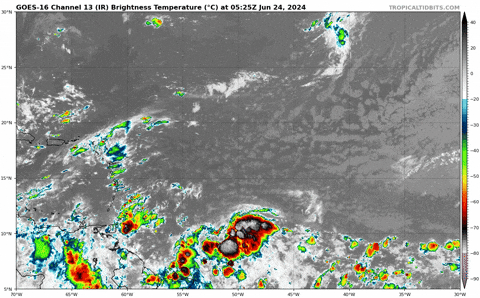
Waves at 6/24/24 on 06z analysis.
An eastern Atlantic tropical wave is along 25W, south of 15N,
moving westward at 10-15 kt. Scattered showers are noted along
the wave's axis.
A central Atlantic tropical wave has is along 45W, south of 13N,
moving westward at 15 kt. Scattered showers are noted along
the wave's axis.
Another central Atlantic tropical wave is along 58W, south of
20N, moving westward at 15 kt. Scattered moderate convection is
noted along the wave's axis, from 10N-14N.
A central Caribbean tropical wave is along 70W, south of 16N,
moving westward at 10-15 kt. No significant convection is noted at
this time.
A western Caribbean/EPAC tropical wave is along 87W, south of
18N, moving westward at 10-15 kt. Scattered showers and isolated
thunderstorms are within 120 nm W of the wave axis south of 14N,
affecting the Gulf of Honduras.
0 likes
Visit the Caribbean-Central America Weather Thread where you can find at first post web cams,radars
and observations from Caribbean basin members Click Here
and observations from Caribbean basin members Click Here
-
tropicwatch

- Category 5

- Posts: 3427
- Age: 62
- Joined: Sat Jun 02, 2007 10:01 am
- Location: The Villages, Florida
- Contact:
Re: 2024 Tropical Waves
REDHurricane wrote:The wave at 50W is looking very healthy for June as it approaches South America:
https://media2.giphy.com/media/v1.Y2lkPTc5MGI3NjExeHdtMDlpamgxdzJubzdlN3U5OWo5dzVha3l4bWM0ajE0aWM5cWJ4diZlcD12MV9pbnRlcm5hbF9naWZfYnlfaWQmY3Q9Zw/4UcoggQnBUJCCT1Sgk/giphy.gif
Just took a look at this one. It has some 850mb vorticity, the shear is currently not that bad above it, the mid-level shear appears to be rotating with the vorticity and it has decent convection. The SAL is currently north of it. Might see a lemon today.
1 likes
Tropicwatch
Agnes 72', Eloise 75, Elena 85', Kate 85', Charley 86', Florence 88', Beryl 94', Dean 95', Erin 95', Opal 95', Earl 98', Georges 98', Ivan 2004', Arlene 2005', Dennis 2005', Ida 2009' Debby 2012' Irma 2017' Michael 2018'
Agnes 72', Eloise 75, Elena 85', Kate 85', Charley 86', Florence 88', Beryl 94', Dean 95', Erin 95', Opal 95', Earl 98', Georges 98', Ivan 2004', Arlene 2005', Dennis 2005', Ida 2009' Debby 2012' Irma 2017' Michael 2018'

Re: 2024 Tropical Waves
Eastern Caribbean graveyard should do its job, but the wave at 55W is stacked, has substantial lower level vorticity that has been increasing in strength over the past 6 hours, and as mentioned above is showing favorable convection patterns. Wouldn’t be surprised to see some short term over performance and development.
0 likes
-
cycloneye
- Admin
- Posts: 149703
- Age: 69
- Joined: Thu Oct 10, 2002 10:54 am
- Location: San Juan, Puerto Rico
Re: 2024 Tropical Waves
1 likes
Visit the Caribbean-Central America Weather Thread where you can find at first post web cams,radars
and observations from Caribbean basin members Click Here
and observations from Caribbean basin members Click Here
-
cycloneye
- Admin
- Posts: 149703
- Age: 69
- Joined: Thu Oct 10, 2002 10:54 am
- Location: San Juan, Puerto Rico
Re: 2024 Tropical Waves
Waves at 6/25/24 on 06z analysis.

An eastern Atlantic tropical wave is along 27W, south of 15N,
moving westward at 10 kt. Scattered moderate convection is noted
from 05N to 10N and between 20W and 30W.
An eastern Caribbean tropical wave is along 62W, south of 18N,
moving westward at around 10 kt. This wave is the combination of
2 waves depicted in the previous map. Scattered moderate
convection prevails S of 14N between 60W-65W.
A central Caribbean tropical wave is along 74W, south of 16N,
moving westward at 10 kt. The wave axis is enhancing the storm
activity over Colombia.
1 likes
Visit the Caribbean-Central America Weather Thread where you can find at first post web cams,radars
and observations from Caribbean basin members Click Here
and observations from Caribbean basin members Click Here
-
cycloneye
- Admin
- Posts: 149703
- Age: 69
- Joined: Thu Oct 10, 2002 10:54 am
- Location: San Juan, Puerto Rico
Re: 2024 Tropical Waves
Waves at 6/26/24 on 06z analysis.
A tropical wave is in the E Atlantic extending from 03N to 15N
with axis near 28W, moving westward at 5 to 10 kt. Scattered
moderate convection is noted from 04N to 11N between 23W and 36W.
A tropical wave is in the central Atlantic extending from 05N to
19N with axis near 45W, moving westward at 5 to 10 kt. Widely
scattered moderate convection is noted from 02N to 10N between 36W
and 50W.
A tropical wave is moving across the central Caribbean with axis S
of 17N near 71W, moving westward around 10 kt. Scattered moderate
convection is from 13N to 19N between 67W and 77W.
A tropical wave is in the W Caribbean S of 16N with axis near 82W,
moving W at 10-15 kt. Scattered moderate isolated strong
convection is S of 17N W of 79W.
0 likes
Visit the Caribbean-Central America Weather Thread where you can find at first post web cams,radars
and observations from Caribbean basin members Click Here
and observations from Caribbean basin members Click Here
-
cycloneye
- Admin
- Posts: 149703
- Age: 69
- Joined: Thu Oct 10, 2002 10:54 am
- Location: San Juan, Puerto Rico
Re: 2024 Tropical Waves
Waves at 6/27/24 on 06z analysis.

Invest AL95: A tropical wave extends from 02N to 15N with axis
near 32W, moving west at 5 to 10 kt. Scattered moderate
convection is noted from 02N to 11N between 27W and 45W.
Environmental conditions are forecast to be unusually conducive
for late June across the central and western tropical Atlantic,
and further development of this system is anticipated. A tropical
depression or tropical storm is likely to form this weekend
several hundred miles east of the Windward Islands while the
system moves westward at 15 to 20 kt. Please read the latest
Tropical Weather Outlook issued by the National Hurricane Center
at website - https://www.nhc.noaa.gov for further details.
...TROPICAL WAVES...
A tropical wave is in the central Atlantic extending from 04N to
19N with axis near 49W, moving west at 10 to 15 kt. Widely
scattered showers are confined to the ITCZ from 08N to 11N between
46W and 55W.
A tropical wave is in the western Caribbean south of 18N with axis
near 80W, moving west at 15 to 20 kt. Numerous moderate to strong
convection is from 13N to 20N between 73W and 85W. Environmental
conditions could become more conducive for some gradual
development later this week over the western Caribbean Sea or over
the southwestern Gulf of Mexico during the weekend.
0 likes
Visit the Caribbean-Central America Weather Thread where you can find at first post web cams,radars
and observations from Caribbean basin members Click Here
and observations from Caribbean basin members Click Here
-
Hurricane2022

- Category 5
- Posts: 2092
- Joined: Tue Aug 23, 2022 11:38 pm
- Location: Araçatuba, Brazil
Re: 2024 Tropical Waves

1 likes
Sorry for the bad English sometimes...!
For reliable and detailed information for any meteorological phenomenon, please consult the National Hurricane Center, Joint Typhoon Warning Center , or your local Meteo Center.
--------
ECCE OMNIA NOVA FACIAM (Ap 21,5).
For reliable and detailed information for any meteorological phenomenon, please consult the National Hurricane Center, Joint Typhoon Warning Center , or your local Meteo Center.
--------
ECCE OMNIA NOVA FACIAM (Ap 21,5).
-
cycloneye
- Admin
- Posts: 149703
- Age: 69
- Joined: Thu Oct 10, 2002 10:54 am
- Location: San Juan, Puerto Rico
Re: 2024 Tropical Waves
Waves at 6/28/24 on 06z analysis.
Invest AL95 Gale Warning: Showers and thunderstorms continue to
show signs of organization in association with a tropical wave
located several hundred nautical miles west-southwest of the Cabo
Verde Islands near 09.5N38W. Scattered to numerous moderate
convection is noted from 02N to 10N between 35W and 38W, and from
04N to 12N between 38W and 43W. Winds are currently 20 to 30 kt
with seas of 7 to 9 ft. Environmental conditions appear conducive
for additional development, and a tropical depression or tropical
storm is likely to form over the next day or two. This system is
expected to move westward at 15 to 20 kt towards the Windward
Islands. Interests in the Lesser Antilles should monitor the
progress of this system. There is a high chance of tropical
cyclone formation for the next 2 to 7 days. A gale warning has
been issued beginning Sat afternoon, with storm conditions
possible beginning Sun afternoon as the feature moves into
portions of the Tropical N Atlantic offshore waters zones.
Building seas will occur with increasing winds.
Please read the latest Tropical Weather Outlook issued by the
National Hurricane Center at website:
https://www.nhc.noaa.gov for further details.
An eastern Atlantic tropical wave is near 20W/21W from 13N
southward, and moving west at around 15 kt. Isolated to widely
scattered moderate convection is noted from 03N to 07N between 20W
and 25W.
An central Atlantic tropical wave is near 38W from 15N southward
through AL95 mentioned in the Special Feature section, and moving
west around 10 kt. Associated convection is described above.
A western Atlantic tropical wave is near 54W from 20N southward,
and moving west at around 10 kt. Scattered moderate convection is
present from 16N to 20N between 51W and 54W.
A western Caribbean tropical wave is near 83W/84W from southwest
of the Cayman Islands southward through a broad low pressure
(AL94) near Honduras-Nicaragua coastal border to eastern Costa
Rica. The whole system is moving westward at around 10 kt.
Scattered moderate isolated strong convection is present from 12N
to 20N between 79W and 86W. Some development of this system is
possible over the northwestern Caribbean Sea or over the
southwestern Gulf of Mexico during the next few days.
0 likes
Visit the Caribbean-Central America Weather Thread where you can find at first post web cams,radars
and observations from Caribbean basin members Click Here
and observations from Caribbean basin members Click Here
-
cycloneye
- Admin
- Posts: 149703
- Age: 69
- Joined: Thu Oct 10, 2002 10:54 am
- Location: San Juan, Puerto Rico
Re: 2024 Tropical Waves
Waves at 6/29/24 on 06z analysis.
An eastern Atlantic tropical wave is near 30W from 13N southward,
or several hundred nautical miles south-southwest of the Cabo
Verde Islands, and moving west at around 10 kt. Scattered
moderate isolated strong convection is seen from 01N to 10N
between 21W and 35W. Environmental conditions appear conducive for
additional development of this system, and a tropical depression
could form by the middle of next week while it moves generally
westward at 15 to 20 kt across the eastern and central tropical
Atlantic. Please refer to the latest Tropical Weather Outlook
issued by the National Hurricane Center at
www.nhc.noaa.gov/gtwo.php?basin=atlc&fdays=7 for more
details.
A western Atlantic tropical wave is just east of Barbados near
58W/59W from 20N southward into Guyana, and moving west at 10 to
15 kt. Scattered moderate isolated strong convection is present
from 10N to 14N between 55W and 68W, with additional convection
over much of Venezuela.
A western Caribbean tropical wave (AL94) is near 87W/88W from the
western Yucatan Channel southward near Cozumel and through the
Gulf of Honduras into Honduras and Nicaragua. It is moving west-
northwestward at around 10 kt. Refer to the Special Features
section for wind and sea conditions, convection and potential for
tropical development.
0 likes
Visit the Caribbean-Central America Weather Thread where you can find at first post web cams,radars
and observations from Caribbean basin members Click Here
and observations from Caribbean basin members Click Here
-
cycloneye
- Admin
- Posts: 149703
- Age: 69
- Joined: Thu Oct 10, 2002 10:54 am
- Location: San Juan, Puerto Rico
Re: 2024 Tropical Waves
Waves at 6/30/24 on 06z analysis.
An eastern Atlantic tropical wave is along 32W, south of 12N,
moving westward at 10-15 kt, coincident with Invest 96L near
07.5N32W. Refer to the Special Features section for details on
nearby convection.
A Caribbean Sea tropical wave extends from Puerto Rico near 19N66W
south-southwestward to Venezuela near 06N68W, moving westward at
10-15 kt. No significant convection is noted with the tropical
wave.
A Bay of Campeche tropical wave (Invest 94L) is along 93W, south
of 23N, moving west-northwestward at around 10 kt. Refer to the
Special Features section for more information
0 likes
Visit the Caribbean-Central America Weather Thread where you can find at first post web cams,radars
and observations from Caribbean basin members Click Here
and observations from Caribbean basin members Click Here
-
cycloneye
- Admin
- Posts: 149703
- Age: 69
- Joined: Thu Oct 10, 2002 10:54 am
- Location: San Juan, Puerto Rico
Re: 2024 Tropical Waves
Waves at 7/2/24 on 06z analisis.
A tropical wave is in the eastern Atlantic along 20W, south of
18N, and moving westward at around 10 kt. Scattered moderate
isolated strong convection is noted from 05N to 14N between the
coast of Africa and 30W.
A central Atlantic tropical wave (Invest 96L) is along 44.5W,
south of 17N, moving westward at 15 to 20 kt. Isolated to widely
scattered moderate convection is noted from 09N to 12N between
44.5W and 48.5W. Associated winds are currently 20 to 25 kt with
seas of 7 to 10 ft. Environmental conditions are only marginally
conducive for additional development of this system while it moves
generally westward at 15 to 20 kt across the central and western
tropical Atlantic. Interests in the Lesser Antilles should still
monitor the progress of this system, with heavy rainfall possible
midweek. This system has a low chance of development in the next
48 hours and 7 days. Please refer to the latest NHC Tropical
Weather Outlook at www.hurricanes.gov for more details.
A western Caribbean tropical wave is along 81W, south of 20N,
moving westward at around 10 kt. Scattered moderate to isolated
strong convection is present in the SW Caribbean from 09N to 13N
between 76W and 83.5W, and from 13N to 20N between the tropical
wave axis and 87W.
0 likes
Visit the Caribbean-Central America Weather Thread where you can find at first post web cams,radars
and observations from Caribbean basin members Click Here
and observations from Caribbean basin members Click Here
-
cycloneye
- Admin
- Posts: 149703
- Age: 69
- Joined: Thu Oct 10, 2002 10:54 am
- Location: San Juan, Puerto Rico
Re: 2024 Tropical Waves
Waves at 7/3/24 on 12z analysis.
A tropical wave is just west of the Cabo Verde Islands extending
from 04N to 20N with axis near 29W, moving westward at 15 to 20
kt. Scattered moderate convection is mainly linked to the monsoon
and ITCZ from 06N to 11N between 25W and 33W.
A tropical wave (Invest 96L) is moving across the Lesser Antilles
with axis near 61W early this afternoon. The wave is moving
westward very rapidly westward at 25-30 kt. Scattered moderate
isolated strong convection is from 10N to 16N between 57W and
65W. Associated winds are 20 to 30 kt with seas of 8 to 12 ft.
Development, if any, of this system should be slow to occur
while it moves quickly westward to west-northwestward across the
Caribbean Sea. Regardless of development, gusty winds and locally
heavy rainfall are possible across portions of the Lesser Antilles
today. Please refer to the latest NHC Tropical Weather Outlook at
http://www.hurricanes.gov for more details.
A tropical wave formerly in the far western Caribbean is now
inland Central America with axis near 89W and is not generating
convection over the Caribbean waters.
0 likes
Visit the Caribbean-Central America Weather Thread where you can find at first post web cams,radars
and observations from Caribbean basin members Click Here
and observations from Caribbean basin members Click Here
Who is online
Users browsing this forum: No registered users and 227 guests