2024 Indicators: SST's, MSLP, Shear, SAL, Steering, Instability (Day 16+ Climate Models)

This is the general tropical discussion area. Anyone can take their shot at predicting a storms path.

Moderator: S2k Moderators

Forum rules

The posts in this forum are NOT official forecasts and should not be used as such. They are just the opinion of the poster and may or may not be backed by sound meteorological data. They are NOT endorsed by any professional institution or STORM2K. For official information, please refer to products from the National Hurricane Center and National Weather Service.

Help Support Storm2K
Message
Author
User avatar
Hurricane2022
Category 5
Category 5
Posts: 1543
Joined: Tue Aug 23, 2022 11:38 pm
Location: Araçatuba, Brazil

Re: 2024 Indicators: SST's, MSLP, Shear, SAL, Steering, Instability (Day 16+ Climate Models)

#1301 Postby Hurricane2022 » Sat Jun 22, 2024 12:04 pm

Its just for fun, because 2024 is not going to be your usual "above-average" hurricane season.. :sun:
Captain Barbossa's Tropical Cyclone Timeline:

1. June 1st: Everyone is excited about the upcoming season. Many are anticipating upcoming action later in the month, but most know that the real action will most likely start in August.

2. July 1st: One or two TCs manage to form in June. Many complain about how weak and disorganized the cyclones are.

3. July 15th: Lots of SAL is present in the Atlantic basin. However, most people are not surprised by this, as they were expecting it.

4. August 1st: Atlantic is still slow. Dry, stable air is present in the tropics. However, models are beginning to suggest things will be changing within a few weeks.

5. August 15th: Models show nothing in the near-future. Many are becoming skeptical about the season amounting to anything significant.

6. August 23rd: There are multiple invests in the Atlantic and conditions are rapidly beginning to change. The models begin to show cyclogenesis. Many quickly change their minds about a quieter season.

7. August 24th: Some experts continue to doubt signs of the Atlantic awakening. These experts issue outlooks that support original ideas of a quieter (or not) season.

8. August 31st: There is now at least one active TC. There is a potential that at least one TC could become a hurricane. Many people appear shocked by the increased activity.

9. September 30th: Several TCs have already formed and dissipated. A few who suggested that the season would be quiet now state that they always knew the Atlantic would spring to life.

10. November 30th: The last storm probably has dissipated by this point. Many look back at the season and state that they are surprised with the outcome.
11 likes   
Sorry for the bad English sometimes...!
For reliable and detailed information for any meteorological phenomenon, please consult the National Hurricane Center, Joint Typhoon Warning Center , or your local Meteo Center.

--------

Una cvm Christo, pro Christo, et in Christo. Sit nomen Domini benedictvm.

User avatar
DorkyMcDorkface
Category 3
Category 3
Posts: 888
Age: 27
Joined: Mon Sep 30, 2019 1:32 pm
Location: Mid-Atlantic

Re: 2024 Indicators: SST's, MSLP, Shear, SAL, Steering, Instability (Day 16+ Climate Models)

#1302 Postby DorkyMcDorkface » Sun Jun 23, 2024 4:07 pm

2 likes   
Please note the thougths expressed by this account are solely those of the user and are from a hobbyist perspective. For more comprehensive analysis, consult an actual professional meteorologist or meteorology agency.


Floyd 1999 | Isabel 2003 | Hanna 2008 | Irene 2011 | Sandy 2012 | Isaias 2020

LarryWx
S2K Supporter
S2K Supporter
Posts: 6305
Joined: Sun Sep 07, 2003 2:04 pm
Location: GA

Re: 2024 Indicators: SST's, MSLP, Shear, SAL, Steering, Instability (Day 16+ Climate Models)

#1303 Postby LarryWx » Mon Jun 24, 2024 9:01 am

I’m assuming this is meaningless as far as forecast value for the meat of the season (i.e., not at all “season cancel”) and we did have a close call with Invest 92L off GA, but I imagine it could imply a little something for the total # of NS this season (perhaps shave off 1 NS) in a season with extremely high numbers of NS being forecasted.

Total # of NS through July 1st (excluding NS before May 1):

2024: ? (1 so far)
2023: 3
2022: 3
2021: 5
2020: 4
2019: 1
2018: 1
2017: 2
2016: 3
2015: 2
2014: 1
2013: 2
2012: 4
2011: 1
2010: 1
2009: 0
2008: 1
2007: 2
2006: 1
2005: 2
2004: 0
2003: 1
2002: 0
2001: 1
2000: 0
1999: 1
1998: 0
1997: 2
1996: 1
1995: 1

AVG 1995-2023: 1.5

Any thoughts?
0 likes   
Personal Forecast Disclaimer:
The posts in this forum are NOT official forecasts and should not be used as such. They are just the opinion of the poster and may or may not be backed by sound meteorological data. They are NOT endorsed by any professional institution or storm2k.org. For official information, please refer to the NHC and NWS products.

tolakram
Admin
Admin
Posts: 20009
Age: 62
Joined: Sun Aug 27, 2006 8:23 pm
Location: Florence, KY (name is Mark)

Re: 2024 Indicators: SST's, MSLP, Shear, SAL, Steering, Instability (Day 16+ Climate Models)

#1304 Postby tolakram » Mon Jun 24, 2024 9:03 am

We are behind both 2005 and 2013. SEASON IS A DUD. :lol:

Seriously though if a system gets names is all about position of the disturbance. We've seen some attempted development by everything so far.
6 likes   
M a r k
- - - - -
Join us in chat: Storm2K Chatroom Invite. Android and IOS apps also available.

The posts in this forum are NOT official forecasts and should not be used as such. Posts are NOT endorsed by any professional institution or STORM2K.org. For official information and forecasts, please refer to NHC and NWS products.

User avatar
ScottNAtlanta
Category 5
Category 5
Posts: 2367
Joined: Sat May 25, 2013 3:11 pm
Location: Atlanta, GA

Re: 2024 Indicators: SST's, MSLP, Shear, SAL, Steering, Instability (Day 16+ Climate Models)

#1305 Postby ScottNAtlanta » Mon Jun 24, 2024 9:36 am

0 likes   
The posts in this forum are NOT official forecast and should not be used as such. They are just the opinion of the poster and may or may not be backed by sound meteorological data. They are NOT endorsed by any professional institution or storm2k.org. For official information, please refer to the NHC and NWS products.

User avatar
skyline385
Category 5
Category 5
Posts: 2728
Age: 35
Joined: Wed Aug 26, 2020 11:15 pm
Location: Houston TX

Re: 2024 Indicators: SST's, MSLP, Shear, SAL, Steering, Instability (Day 16+ Climate Models)

#1306 Postby skyline385 » Mon Jun 24, 2024 9:41 am

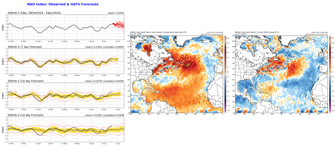
Seems like we are going through a round of strong +NAO which has likely made the MDR slightly unfavorable despite the ridiculous SSTs simply from the enhanced trades and consequently cooled the anomalies a bit. An interesting result of the persistent +NAO also has been colder anomalies developing around the Canary current but I don't expect this to matter much in the end, only going to somewhat affect the NS spam during early season. We already have seen a NS and several invests try to develop pretty convincingly despite unfavorable conditions and I fully expect the season to go crazy as soon as conditions improve even slightly. We are already seeing a preview of what's coming with the EPAC and WPAC pretty much shutdown while the extended model runs show an African Standing Wave going into July which will combine with an already active AEJ as seen by the wave trains we have had for the last month (even right now, there are 5 active tropical waves in the NATL).

Image
2 likes   

User avatar
cycloneye
Admin
Admin
Posts: 145322
Age: 68
Joined: Thu Oct 10, 2002 10:54 am
Location: San Juan, Puerto Rico

Re: 2024 Indicators: SST's, MSLP, Shear, SAL, Steering, Instability (Day 16+ Climate Models)

#1307 Postby cycloneye » Mon Jun 24, 2024 10:19 am

1 likes   
Visit the Caribbean-Central America Weather Thread where you can find at first post web cams,radars
and observations from Caribbean basin members Click Here

zzzh
Category 3
Category 3
Posts: 834
Joined: Thu Sep 02, 2021 1:13 pm

Re: 2024 Indicators: SST's, MSLP, Shear, SAL, Steering, Instability (Day 16+ Climate Models)

#1308 Postby zzzh » Mon Jun 24, 2024 12:55 pm

NAO during the summer can only modulate SSTs in the subtropics/extratropics (i.e. canary current). MDR/Caribbean are more influenced by tropical forcings.
0 likes   

psyclone
S2K Supporter
S2K Supporter
Posts: 4762
Joined: Wed Aug 24, 2005 9:04 pm
Location: palm harbor fl

Re: 2024 Indicators: SST's, MSLP, Shear, SAL, Steering, Instability (Day 16+ Climate Models)

#1309 Postby psyclone » Mon Jun 24, 2024 1:17 pm

I recall 2005 have some early season short fused tropical systems in the bay of campeche/sw gulf..that region had a very hot hand early on but it was otherwise forgettable as the systems didn't get strong...they ran out of room. To see that region so active early on gives me that 05 vibe. Of course July 2005 was insane...so hopefully our paths diverge soon...they most likely will...for now..
2 likes   

User avatar
WiscoWx02
Category 1
Category 1
Posts: 391
Joined: Sat Jul 31, 2021 8:09 pm

Re: 2024 Indicators: SST's, MSLP, Shear, SAL, Steering, Instability (Day 16+ Climate Models)

#1310 Postby WiscoWx02 » Mon Jun 24, 2024 5:43 pm

skyline385 wrote:Seems like we are going through a round of strong +NAO which has likely made the MDR slightly unfavorable despite the ridiculous SSTs simply from the enhanced trades and consequently cooled the anomalies a bit. An interesting result of the persistent +NAO also has been colder anomalies developing around the Canary current but I don't expect this to matter much in the end, only going to somewhat affect the NS spam during early season. We already have seen a NS and several invests try to develop pretty convincingly despite unfavorable conditions and I fully expect the season to go crazy as soon as conditions improve even slightly. We are already seeing a preview of what's coming with the EPAC and WPAC pretty much shutdown while the extended model runs show an African Standing Wave going into July which will combine with an already active AEJ as seen by the wave trains we have had for the last month (even right now, there are 5 active tropical waves in the NATL).

[url]https://i.postimg.cc/kMYgs4ML/combine-images-10.png [/url]


Yep…the anomalies are starting to go the other direction now in parts of the eastern Atlantic. Have been waiting for this to happen for a while, figured it would. Hovmollers show enhanced trades dominating the MDR the next few weeks as well so I would expect additional cooling from here on top of the SAL blocking out radiation from the sun.
0 likes   

User avatar
skyline385
Category 5
Category 5
Posts: 2728
Age: 35
Joined: Wed Aug 26, 2020 11:15 pm
Location: Houston TX

Re: 2024 Indicators: SST's, MSLP, Shear, SAL, Steering, Instability (Day 16+ Climate Models)

#1311 Postby skyline385 » Mon Jun 24, 2024 6:11 pm

WiscoWx02 wrote:
skyline385 wrote:Seems like we are going through a round of strong +NAO which has likely made the MDR slightly unfavorable despite the ridiculous SSTs simply from the enhanced trades and consequently cooled the anomalies a bit. An interesting result of the persistent +NAO also has been colder anomalies developing around the Canary current but I don't expect this to matter much in the end, only going to somewhat affect the NS spam during early season. We already have seen a NS and several invests try to develop pretty convincingly despite unfavorable conditions and I fully expect the season to go crazy as soon as conditions improve even slightly. We are already seeing a preview of what's coming with the EPAC and WPAC pretty much shutdown while the extended model runs show an African Standing Wave going into July which will combine with an already active AEJ as seen by the wave trains we have had for the last month (even right now, there are 5 active tropical waves in the NATL).

[url]https://i.postimg.cc/kMYgs4ML/combine-images-10.png [/url]


Yep…the anomalies are starting to go the other direction now in parts of the eastern Atlantic. Have been waiting for this to happen for a while, figured it would. Hovmollers show enhanced trades dominating the MDR the next few weeks as well so I would expect additional cooling from here on top of the SAL blocking out radiation from the sun.


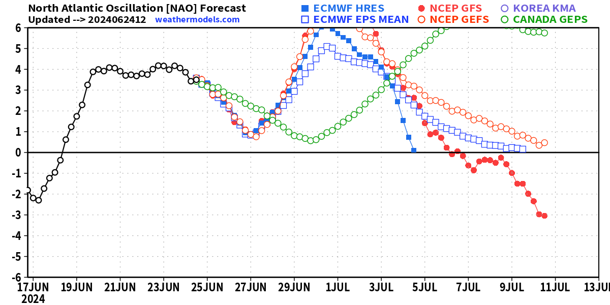
All models/ensembles forecast another round of stronger +NAO so its going to continue for atleast the next week for now. 2024 literally pulling another 2010 with the +NAO spam.

Image
0 likes   

User avatar
cycloneye
Admin
Admin
Posts: 145322
Age: 68
Joined: Thu Oct 10, 2002 10:54 am
Location: San Juan, Puerto Rico

Re: 2024 Indicators: SST's, MSLP, Shear, SAL, Steering, Instability (Day 16+ Climate Models)

#1312 Postby cycloneye » Mon Jun 24, 2024 8:58 pm

0 likes   
Visit the Caribbean-Central America Weather Thread where you can find at first post web cams,radars
and observations from Caribbean basin members Click Here

User avatar
NotSparta
Professional-Met
Professional-Met
Posts: 1670
Age: 23
Joined: Fri Aug 18, 2017 8:24 am
Location: Naples, FL
Contact:

Re: 2024 Indicators: SST's, MSLP, Shear, SAL, Steering, Instability (Day 16+ Climate Models)

#1313 Postby NotSparta » Tue Jun 25, 2024 12:58 am

skyline385 wrote:
WiscoWx02 wrote:
skyline385 wrote:Seems like we are going through a round of strong +NAO which has likely made the MDR slightly unfavorable despite the ridiculous SSTs simply from the enhanced trades and consequently cooled the anomalies a bit. An interesting result of the persistent +NAO also has been colder anomalies developing around the Canary current but I don't expect this to matter much in the end, only going to somewhat affect the NS spam during early season. We already have seen a NS and several invests try to develop pretty convincingly despite unfavorable conditions and I fully expect the season to go crazy as soon as conditions improve even slightly. We are already seeing a preview of what's coming with the EPAC and WPAC pretty much shutdown while the extended model runs show an African Standing Wave going into July which will combine with an already active AEJ as seen by the wave trains we have had for the last month (even right now, there are 5 active tropical waves in the NATL).

[url]https://i.postimg.cc/kMYgs4ML/combine-images-10.png [/url]


Yep…the anomalies are starting to go the other direction now in parts of the eastern Atlantic. Have been waiting for this to happen for a while, figured it would. Hovmollers show enhanced trades dominating the MDR the next few weeks as well so I would expect additional cooling from here on top of the SAL blocking out radiation from the sun.


All models/ensembles forecast another round of stronger +NAO so its going to continue for atleast the next week for now. 2024 literally pulling another 2010 with the +NAO spam.

[url]https://i.postimg.cc/cCpMknfc/image.png [/url]


2010? +NAO? You could barely even buy a +NAO back in 2010
4 likes   
This post was probably an opinion of mine, and in no way is official. Please refer to http://www.hurricanes.gov for official tropical analysis and advisories.

My website, with lots of tropical wx graphics, including satellite and recon: http://cyclonicwx.com

User avatar
skyline385
Category 5
Category 5
Posts: 2728
Age: 35
Joined: Wed Aug 26, 2020 11:15 pm
Location: Houston TX

Re: 2024 Indicators: SST's, MSLP, Shear, SAL, Steering, Instability (Day 16+ Climate Models)

#1314 Postby skyline385 » Tue Jun 25, 2024 8:51 am

NotSparta wrote:
skyline385 wrote:
WiscoWx02 wrote:
Yep…the anomalies are starting to go the other direction now in parts of the eastern Atlantic. Have been waiting for this to happen for a while, figured it would. Hovmollers show enhanced trades dominating the MDR the next few weeks as well so I would expect additional cooling from here on top of the SAL blocking out radiation from the sun.


All models/ensembles forecast another round of stronger +NAO so its going to continue for atleast the next week for now. 2024 literally pulling another 2010 with the +NAO spam.

[url]https://i.postimg.cc/cCpMknfc/image.png [/url]


2010? +NAO? You could barely even buy a +NAO back in 2010


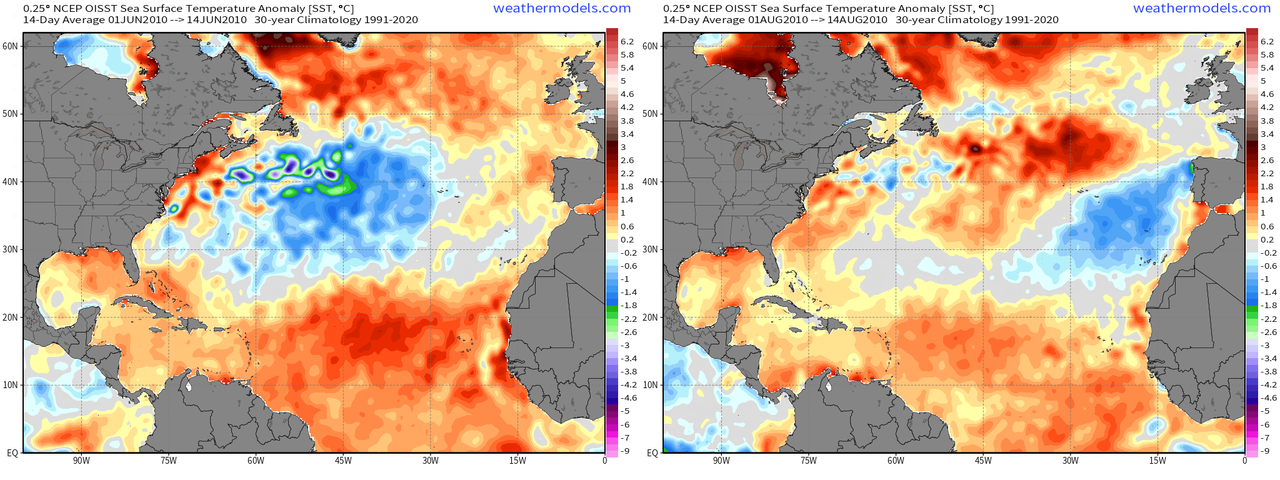
Didn't 2010 have a couple of +NAO rounds which decreased the anomalies in the deep tropics (which were at record high at that time) & the Canary current while heating up the subtropics as we got into peak season? Or am i thinking of some other year here?

Image
0 likes   

User avatar
wxman57
Moderator-Pro Met
Moderator-Pro Met
Posts: 22979
Age: 67
Joined: Sat Jun 21, 2003 8:06 pm
Location: Houston, TX (southwest)

Re: 2024 Indicators: SST's, MSLP, Shear, SAL, Steering, Instability (Day 16+ Climate Models)

#1315 Postby wxman57 » Tue Jun 25, 2024 9:07 am

The entire Northern Hemisphere is quiet as of June 25th. NH ACE is about 21% of normal. Not a single East Pac storm and only one NW Pac typhoon. The Atlantic remains quiet. I'm quite hopeful that all the predictions of a hyperactive season were wrong. However, I remember 2004, when the first storm formed July 31st. Meanwhile, I'll enjoy the quiet.

http://wxman57.com/images/NHACE.png

Image
6 likes   

LarryWx
S2K Supporter
S2K Supporter
Posts: 6305
Joined: Sun Sep 07, 2003 2:04 pm
Location: GA

Re: 2024 Indicators: SST's, MSLP, Shear, SAL, Steering, Instability (Day 16+ Climate Models)

#1316 Postby LarryWx » Tue Jun 25, 2024 10:09 am

skyline385 wrote:
NotSparta wrote:
skyline385 wrote:
All models/ensembles forecast another round of stronger +NAO so its going to continue for atleast the next week for now. 2024 literally pulling another 2010 with the +NAO spam.

[url]https://i.postimg.cc/cCpMknfc/image.png [/url]


2010? +NAO? You could barely even buy a +NAO back in 2010


Didn't 2010 have a couple of +NAO rounds which decreased the anomalies in the deep tropics (which were at record high at that time) & the Canary current while heating up the subtropics as we got into peak season? Or am i thinking of some other year here?

[url]https://i.postimg.cc/k5MyCrfb/combine-images-11.png [/url]


The entire 2010 hurricane season was dominated by -NAO. Every month averaged negative:
https://www.cpc.ncep.noaa.gov/products/ ... scii.table

There were only short periods of mainly modest +NAO in 2010. The only exception was the first week in Oct, which had 3 days of strong +NAO.

-NAO has dominated most summers (12 of 17) since 2007. The exceptions were these:
+NAO: 2013, 2018, 2022; neutral NAO: 2017, 2021

The autumns, however, have been much more balanced.
2 likes   
Personal Forecast Disclaimer:
The posts in this forum are NOT official forecasts and should not be used as such. They are just the opinion of the poster and may or may not be backed by sound meteorological data. They are NOT endorsed by any professional institution or storm2k.org. For official information, please refer to the NHC and NWS products.

User avatar
skyline385
Category 5
Category 5
Posts: 2728
Age: 35
Joined: Wed Aug 26, 2020 11:15 pm
Location: Houston TX

Re: 2024 Indicators: SST's, MSLP, Shear, SAL, Steering, Instability (Day 16+ Climate Models)

#1317 Postby skyline385 » Tue Jun 25, 2024 10:45 am

LarryWx wrote:
skyline385 wrote:
NotSparta wrote:
2010? +NAO? You could barely even buy a +NAO back in 2010


Didn't 2010 have a couple of +NAO rounds which decreased the anomalies in the deep tropics (which were at record high at that time) & the Canary current while heating up the subtropics as we got into peak season? Or am i thinking of some other year here?

[url]https://i.postimg.cc/k5MyCrfb/combine-images-11.png [/url]


The entire 2010 hurricane season was dominated by -NAO. Every month averaged negative:
https://www.cpc.ncep.noaa.gov/products/ ... scii.table

There were only short periods of mainly modest +NAO in 2010. The only exception was the first week in Oct, which had 3 days of strong +NAO.

-NAO has dominated most summers (12 of 17) since 2007. The exceptions were these:
+NAO: 2013, 2018, 2022; neutral NAO: 2017, 2021

The autumns, however, have been much more balanced.


The monthly table can sometimes not tell the full picture so I went digging through the daily NAO index archives and there were a couple of rounds of +NAO in early season of 2010, just not as strong and long lasting as I remembered.

June:
6 20 0.22432704269886017
6 21 0.21843627095222473
6 22 0.097271413


July:
7 7 0.095978551
7 8 0.35304689407348633
7 9 0.5573362112045288
7 10 0.7320038080215454
7 11 0.648413897
7 12 0.077601053
------------------------------------
7 31 0.10459507256746292


August:
8 1 0.36901915073394775
8 2 0.6690773963928223
8 3 0.7881171107292175
8 4 0.8275339603424072
8 5 0.6269909739494324
8 6 0.25269579887390137
1 likes   

User avatar
cycloneye
Admin
Admin
Posts: 145322
Age: 68
Joined: Thu Oct 10, 2002 10:54 am
Location: San Juan, Puerto Rico

Re: 2024 Indicators: SST's, MSLP, Shear, SAL, Steering, Instability (Day 16+ Climate Models)

#1318 Postby cycloneye » Tue Jun 25, 2024 10:54 am

0 likes   
Visit the Caribbean-Central America Weather Thread where you can find at first post web cams,radars
and observations from Caribbean basin members Click Here

User avatar
WiscoWx02
Category 1
Category 1
Posts: 391
Joined: Sat Jul 31, 2021 8:09 pm

Re: 2024 Indicators: SST's, MSLP, Shear, SAL, Steering, Instability (Day 16+ Climate Models)

#1319 Postby WiscoWx02 » Wed Jun 26, 2024 12:24 pm

 https://x.com/republicanwx/status/1806006129471750246


The season canceling is beginning to hit its stride. In the comments this poster does bring up a good point about persistent ULL's traversing the Atlantic around the east coast heat dome imparting shear on the tropics but...it is only late June. I am not entirely sold on the accuracy of the CFS model as a whole since it changes so often and can go polar opposite one day to the next. Yes, I do not think this season is going to be as active as most think for my own personal reasons but I don't think it wise to write the season off until this is still a problem come early September, and even then, we'll still likely have hurricanes (99% chance) :lol:
4 likes   

User avatar
weeniepatrol
Category 5
Category 5
Posts: 1276
Joined: Sat Aug 22, 2020 5:30 pm
Location: WA State

Re: 2024 Indicators: SST's, MSLP, Shear, SAL, Steering, Instability (Day 16+ Climate Models)

#1320 Postby weeniepatrol » Fri Jun 28, 2024 12:19 am

Here's an indicator alright :lol:

Image
8 likes   


Return to “Talkin' Tropics”

Who is online

Users browsing this forum: Google Adsense [Bot], StormWeather and 61 guests