ATL: BERYL - Models
Moderator: S2k Moderators
-
cycloneye

- Admin

- Posts: 149677
- Age: 69
- Joined: Thu Oct 10, 2002 10:54 am
- Location: San Juan, Puerto Rico
ATL: BERYL - Models
Only model runs here.
0 likes
Visit the Caribbean-Central America Weather Thread where you can find at first post web cams,radars
and observations from Caribbean basin members Click Here
and observations from Caribbean basin members Click Here
-
Sciencerocks
- Category 5

- Posts: 10189
- Age: 40
- Joined: Thu Jul 06, 2017 1:51 am
Re: ATL: INVEST 95L - Models
https://twitter.com/DylanFedericoWX/status/1806056643374805498
First big sign of the 1996, 2004, 2005 and 2017 analog coming into view.
First big sign of the 1996, 2004, 2005 and 2017 analog coming into view.
1 likes
-
Hurricane2022

- Category 5
- Posts: 2088
- Joined: Tue Aug 23, 2022 11:38 pm
- Location: Araçatuba, Brazil
Re: ATL: INVEST 95L - Models
Latest GEFS

0 likes
Sorry for the bad English sometimes...!
For reliable and detailed information for any meteorological phenomenon, please consult the National Hurricane Center, Joint Typhoon Warning Center , or your local Meteo Center.
--------
ECCE OMNIA NOVA FACIAM (Ap 21,5).
For reliable and detailed information for any meteorological phenomenon, please consult the National Hurricane Center, Joint Typhoon Warning Center , or your local Meteo Center.
--------
ECCE OMNIA NOVA FACIAM (Ap 21,5).


Re: ATL: INVEST 95L - Models
Sciencerocks wrote:https://twitter.com/DylanFedericoWX/status/1806056643374805498
First big sign of the 1996, 2004, 2005 and 2017 analog coming into view.
I wouldn’t jump the gun on 95L just yet. I remember Bonnie ‘22 had some very aggressive Euro runs for a while showing a Caribbean Cruiser major, but the precursor wave was too far south and didn’t develop until it was finally past South America. I’d say there’s a non-zero chance that scenario is on the table for 95L too.
3 likes
Irene '11 Sandy '12 Hermine '16 5/15/2018 Derecho Fay '20 Isaias '20 Elsa '21 Henri '21 Ida '21
I am only a meteorology enthusiast who knows a decent amount about tropical cyclones. Look to the professional mets, the NHC, or your local weather office for the best information.
I am only a meteorology enthusiast who knows a decent amount about tropical cyclones. Look to the professional mets, the NHC, or your local weather office for the best information.
-
MarioProtVI
- Category 5
- Posts: 1038
- Age: 24
- Joined: Sun Sep 29, 2019 7:33 pm
- Location: New Jersey
ATL: INVEST 95L - Discussion
 SHIPS, just why. A major is out of the question and in reality it’ll be falling apart by the end there after peaking at 60-70 kt.
0 likes

Re: ATL: INVEST 95L - Discussion
Keep in mind SHIPS is a statistical model & does not directly take into account time for an invest to organize into a TC. The model treats this as it would your average tropical depression.
MarioProtVI wrote:https://media.discordapp.net/attachments/1158173473861025862/1255635209777451109/tMnkSiPW.png?ex=667dd8ea&is=667c876a&hm=bae6ed595c1f63aee834d70c62aee39e70b9e3dfad5d3fc7d57cd83cea2c362a& SHIPS, just why. A major is out of the question and in reality it’ll be falling apart by the end there after peaking at 60-70 kt.
1 likes
Kendall -> SLO -> PBC
Memorable Storms: Katrina (for its Florida landfall...) Wilma Matthew Irma
Memorable Storms: Katrina (for its Florida landfall...) Wilma Matthew Irma
-
cycloneye
- Admin
- Posts: 149677
- Age: 69
- Joined: Thu Oct 10, 2002 10:54 am
- Location: San Juan, Puerto Rico
Re: ATL: INVEST 95L - Models

0 likes
Visit the Caribbean-Central America Weather Thread where you can find at first post web cams,radars
and observations from Caribbean basin members Click Here
and observations from Caribbean basin members Click Here
-
Category5Kaiju

- Category 5
- Posts: 4345
- Joined: Thu Dec 24, 2020 12:45 pm
- Location: Seattle during the summer, Phoenix during the winter
Re: ATL: INVEST 95L - Models
Did Elsa 2021 and Bonnie 2022 have such intense ensemble signals from the ECMWF? As in, numerous members reaching major strengths like that? Those recent 12z runs really got me wondering that.
0 likes
Unless explicitly stated, all information in my posts is based on my own opinions and observations. Tropical storms and hurricanes can be extremely dangerous. Refer to an accredited weather research agency or meteorologist if you need to make serious decisions regarding an approaching storm.
Re: ATL: INVEST 95L - Models
18Z GFS is running and is the strongest GFS run since 0Z last night.
0 likes
-
jlauderdal
- S2K Supporter

- Posts: 7240
- Joined: Wed May 19, 2004 5:46 am
- Location: NE Fort Lauderdale
- Contact:
Re: RE: Re: ATL: INVEST 95L - Models
Happy Hour GFS, something is going to give as the euro and gfs were seeing things differently in the carib.IcyTundra wrote:18Z GFS is running and is the strongest run since 0Z last night.
0 likes
Re: ATL: INVEST 95L - Models
Category5Kaiju wrote:Did Elsa 2021 and Bonnie 2022 have such intense ensemble signals from the ECMWF? As in, numerous members reaching major strengths like that? Those recent 12z runs really got me wondering that.
Bonnie, yes. The Euro was really trigger happy with that, only for it to bust. I forget what its forecasts for Elsa were like.
Speaking of Elsa, I’m expecting a very similar storm at the most: a Cat 1 passing through the Lesser Antilles before falling apart in the Caribbean.
0 likes
Irene '11 Sandy '12 Hermine '16 5/15/2018 Derecho Fay '20 Isaias '20 Elsa '21 Henri '21 Ida '21
I am only a meteorology enthusiast who knows a decent amount about tropical cyclones. Look to the professional mets, the NHC, or your local weather office for the best information.
I am only a meteorology enthusiast who knows a decent amount about tropical cyclones. Look to the professional mets, the NHC, or your local weather office for the best information.
Re: ATL: INVEST 95L - Models
GFS has a potent hurricane in 5 days with TC formation already within the 2 - 3 day timeframe.

0 likes
Re: ATL: INVEST 95L - Models
18Z GFS weakens 95L in the Caribbean which would make sense this time of year. It has a 2nd system behind 95L that the Euro doesn't have though. Not sure how a 2nd system like that would effect 95L.
0 likes
-
lsuhurricane
- Category 1

- Posts: 270
- Joined: Tue Aug 15, 2017 2:53 pm
Re: ATL: INVEST 95L - Models
Despite the E Car weakening on the 18z GFS, this run screams potential GOM trouble with improving conditions near the Yucutan, which ironically is where the Euro shows it to be.
0 likes

Re: ATL: INVEST 95L - Models
lsuhurricane wrote:Despite the E Car weakening on the 18z GFS, this run screams potential GOM trouble with improving conditions near the Yucutan, which ironically is where the Euro shows it to be.
18Z GFS has ridging along northern gulf coast, brings storm in across the Yucatan south of Cancun.
Significant shear from the south depicted this run all the way across the Caribbean.
Less shear would mean bigger storm probably more pole-ward track earlier.
0 likes
Re: ATL: INVEST 95L - Models
lsuhurricane wrote:Despite the E Car weakening on the 18z GFS, this run screams potential GOM trouble with improving conditions near the Yucutan, which ironically is where the Euro shows it to be.
If 95L is strong enough entering the E Car to survive the "graveyard" it could cause some trouble. The Euro also takes 95L further south in the Caribbean which there might be more favorable conditions in the far south Caribbean.
0 likes
Re: ATL: INVEST 95L - Models
IcyTundra wrote:lsuhurricane wrote:Despite the E Car weakening on the 18z GFS, this run screams potential GOM trouble with improving conditions near the Yucutan, which ironically is where the Euro shows it to be.
If 95L is strong enough entering the E Car to survive the "graveyard" it could cause some trouble. The Euro also takes 95L further south in the Caribbean which there might be more favorable conditions in the far south Caribbean.
I believe the difference in intensity has more to do with orientation of upper level winds. The GFS has upper level winds out of the southwest, directly perpendicular to storm motion, undercutting the outflow layer and inducing shear. OTOH, the Euro maintains upper flow out of the southeast, generally aligned with the storm's motion (potentially even providing ventilation). It looks like the root cause might be difference in orientation of the TUTT far west of the system.
3 likes
Kendall -> SLO -> PBC
Memorable Storms: Katrina (for its Florida landfall...) Wilma Matthew Irma
Memorable Storms: Katrina (for its Florida landfall...) Wilma Matthew Irma

Re: ATL: INVEST 95L - Models
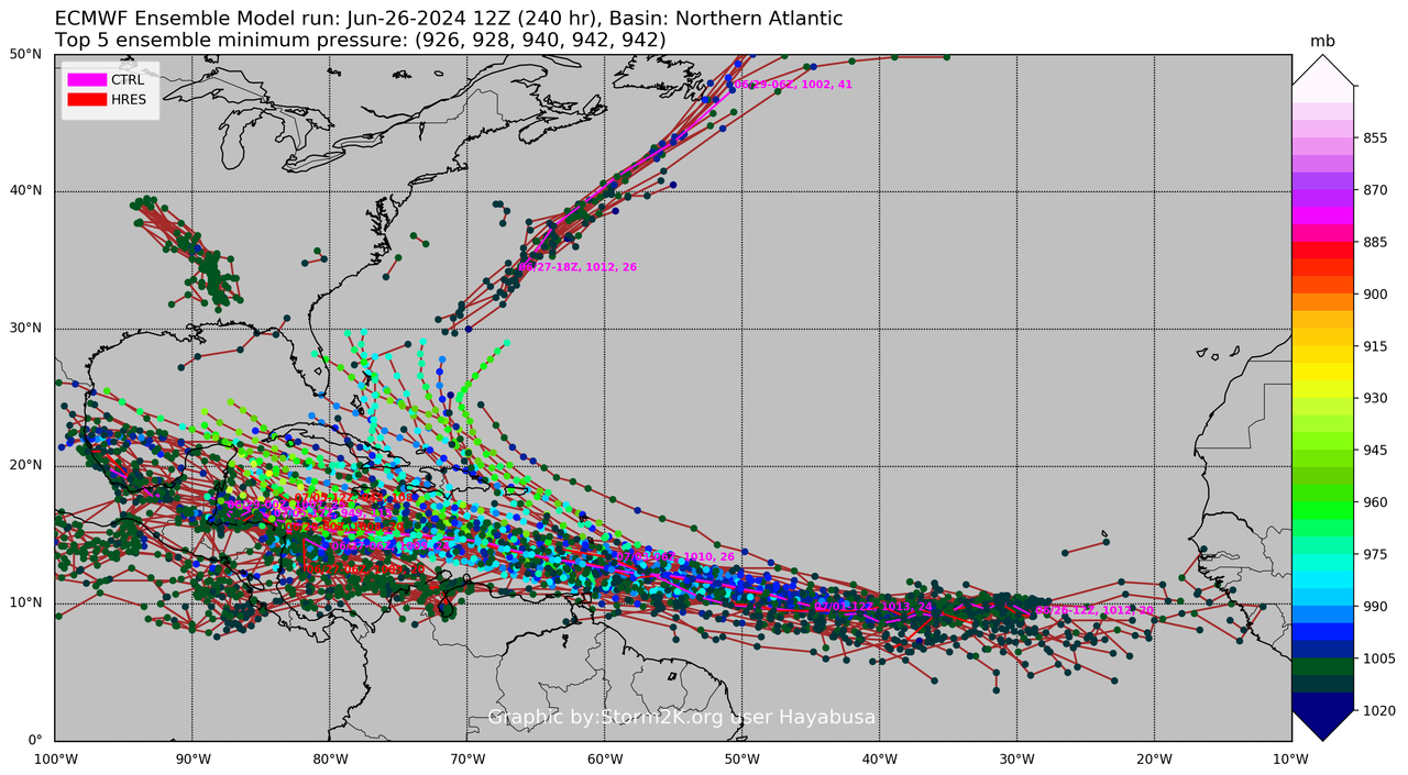
12z eps, very interesting (unlike the Nwpac)
5 likes
ヤンデレ女が寝取られるているのを見たい!!!
ECMWF ensemble NWPAC plots: https://ecmwfensnwpac.imgbb.com/
Multimodel NWPAC plots: https://multimodelnwpac.imgbb.com/
GFS Ensemble NWPAC plots (16 & 35 day forecast): https://gefsnwpac.imgbb.com/
Plots updated automatically
ECMWF ensemble NWPAC plots: https://ecmwfensnwpac.imgbb.com/
Multimodel NWPAC plots: https://multimodelnwpac.imgbb.com/
GFS Ensemble NWPAC plots (16 & 35 day forecast): https://gefsnwpac.imgbb.com/
Plots updated automatically
-
Hurricaneman

- Category 5
- Posts: 7404
- Age: 45
- Joined: Tue Aug 31, 2004 3:24 pm
- Location: central florida
Re: ATL: INVEST 95L - Models
The GFS is trending towards the Euro, might have something more significant in the western Caribbean than we may have otherwise have this time of year, but the Yucatán may have anything from a weak low to major hurricane so stay tuned and while I think this will be a 50mph TS at landfall in the western Caribbean this could be just a wave if TUTT shear stays but a stronger system is also possible but we won’t know until early next week
2 likes
Who is online
Users browsing this forum: No registered users and 72 guests