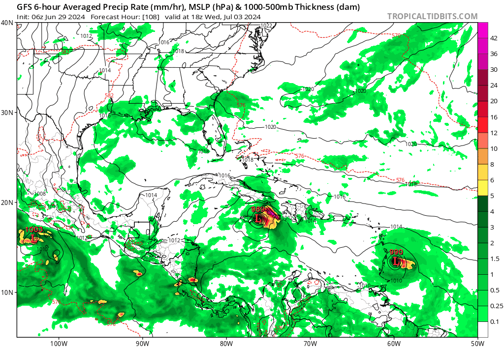
Tropical Wave SW of the Cabo Verde Islands (Is Invest 96L)

This is the general tropical discussion area. Anyone can take their shot at predicting a storms path.

Moderator: S2k Moderators

Forum rules

The posts in this forum are NOT official forecasts and should not be used as such. They are just the opinion of the poster and may or may not be backed by sound meteorological data. They are NOT endorsed by any professional institution or STORM2K. For official information, please refer to products from the National Hurricane Center and National Weather Service.

Help Support Storm2K
Message
Author
BIFF_THE_UNRULY
Tropical Storm
Tropical Storm
Posts: 143
Joined: Fri Jun 28, 2024 2:12 pm

Re: Tropical Wave S of the Cabo Verde Islands

#41 Postby BIFF_THE_UNRULY » Sat Jun 29, 2024 2:28 pm

kevin wrote:


Just your average June with 2 MDR disturbances at the same time, nothing weird going on here...


I mean. Its still behind 2005...which was 19 years ago. The Sun is in an active period right now, we just saw northern lights down in Florida just a month ago.

Alot of this is Sun driven. i would suspect if one looked back at unique hurricane systems in history, they directly correlate to Solar Cycles
2 likes   

User avatar
Cpv17
Category 5
Category 5
Posts: 4915
Joined: Wed Dec 07, 2016 2:24 pm
Location: Wharton/El Campo, TX

Re: Tropical Wave S of the Cabo Verde Islands

#42 Postby Cpv17 » Sat Jun 29, 2024 2:31 pm

BIFF_THE_UNRULY wrote:
kevin wrote:


Just your average June with 2 MDR disturbances at the same time, nothing weird going on here...


I mean. Its still behind 2005...which was 19 years ago. The Sun is in an active period right now, we just saw northern lights down in Florida just a month ago.

Alot of this is Sun driven. i would suspect if one looked back at unique hurricane systems in history, they directly correlate to Solar Cycles


What happened in June of 2005?
1 likes   

BIFF_THE_UNRULY
Tropical Storm
Tropical Storm
Posts: 143
Joined: Fri Jun 28, 2024 2:12 pm

Re: Tropical Wave S of the Cabo Verde Islands

#43 Postby BIFF_THE_UNRULY » Sat Jun 29, 2024 2:32 pm

Cpv17 wrote:
BIFF_THE_UNRULY wrote:
kevin wrote:
Just your average June with 2 MDR disturbances at the same time, nothing weird going on here...


I mean. Its still behind 2005...which was 19 years ago. The Sun is in an active period right now, we just saw northern lights down in Florida just a month ago.

Alot of this is Sun driven. i would suspect if one looked back at unique hurricane systems in history, they directly correlate to Solar Cycles


What happened in June of 2005?


Think we already had Dennis and Emily. Both Category 5's but my memory could be wrong. It was close. Sun was also going through a max cycle at the time
0 likes   

User avatar
cainjamin
Tropical Storm
Tropical Storm
Posts: 168
Age: 34
Joined: Mon Apr 17, 2017 1:38 pm
Location: Nova Scotia, Canada

Re: Tropical Wave S of the Cabo Verde Islands

#44 Postby cainjamin » Sat Jun 29, 2024 2:38 pm

BIFF_THE_UNRULY wrote:
Cpv17 wrote:
BIFF_THE_UNRULY wrote:
I mean. Its still behind 2005...which was 19 years ago. The Sun is in an active period right now, we just saw northern lights down in Florida just a month ago.

Alot of this is Sun driven. i would suspect if one looked back at unique hurricane systems in history, they directly correlate to Solar Cycles


What happened in June of 2005?


Think we already had Dennis and Emily. Both Category 5's but my memory could be wrong. It was close. Sun was also going through a max cycle at the time


Dennis and Emily were both July storms, although Dennis was very early July. Only Emily was a cat 5.
3 likes   
Noel '07, Kyle '08, Earl '10, Arthur '14, Dorian '19, Teddy '20, Lee '23

tolakram
Admin
Admin
Posts: 19990
Age: 61
Joined: Sun Aug 27, 2006 8:23 pm
Location: Florence, KY (name is Mark)

Re: Tropical Wave S of the Cabo Verde Islands

#45 Postby tolakram » Sat Jun 29, 2024 2:45 pm

BIFF_THE_UNRULY wrote:
kevin wrote:


Just your average June with 2 MDR disturbances at the same time, nothing weird going on here...


I mean. Its still behind 2005...which was 19 years ago. The Sun is in an active period right now, we just saw northern lights down in Florida just a month ago.

Alot of this is Sun driven. i would suspect if one looked back at unique hurricane systems in history, they directly correlate to Solar Cycles


Solar cycles are generally 11 years, you can Wikipedia their timeframes. Peak of cycle 23 was Nov 2001 and a minimum and the start of a new cycle was 2008. 2005 was not an active solar year (edit: though Sept 2005 has a spurt of activity) and there is no demonstrated correlation between solar cycles / solar activity and hurricane seasons. :)
8 likes   
M a r k
- - - - -
Join us in chat: Storm2K Chatroom Invite. Android and IOS apps also available.

The posts in this forum are NOT official forecasts and should not be used as such. Posts are NOT endorsed by any professional institution or STORM2K.org. For official information and forecasts, please refer to NHC and NWS products.

tolakram
Admin
Admin
Posts: 19990
Age: 61
Joined: Sun Aug 27, 2006 8:23 pm
Location: Florence, KY (name is Mark)

Re: Tropical Wave SW of the Cabo Verde Islands (30/70)

#46 Postby tolakram » Sat Jun 29, 2024 2:51 pm

Because Beryl is blowing up I suspect this wave doesn't have a chance due to shear. That's usually the way it works, and the Euro is showing a weaker storm now. We'll have to see if this happens or not.
2 likes   
M a r k
- - - - -
Join us in chat: Storm2K Chatroom Invite. Android and IOS apps also available.

The posts in this forum are NOT official forecasts and should not be used as such. Posts are NOT endorsed by any professional institution or STORM2K.org. For official information and forecasts, please refer to NHC and NWS products.

zzzh
Category 3
Category 3
Posts: 833
Joined: Thu Sep 02, 2021 1:13 pm

Re: Tropical Wave SW of the Cabo Verde Islands (30/70)

#47 Postby zzzh » Sat Jun 29, 2024 3:54 pm

Models agree that the distance between beryl and the system is around 20 degree longitude, and they can share a common (big) ULAC.
Also just a side note, Irma and Jose were also around 20 degrees longitude apart. We'll see if the Atlantic is that favorable in a few days :D
0 likes   

User avatar
cycloneye
Admin
Admin
Posts: 143863
Age: 68
Joined: Thu Oct 10, 2002 10:54 am
Location: San Juan, Puerto Rico

Re: Tropical Wave SW of the Cabo Verde Islands (30/70)

#48 Postby cycloneye » Sat Jun 29, 2024 4:41 pm

zzzh wrote:Models agree that the distance between beryl and the system is around 20 degree longitude, and they can share a common (big) ULAC.
Also just a side note, Irma and Jose were also around 20 degrees longitude apart. We'll see if the Atlantic is that favorable in a few days :D


Also some cold waters left by Beryl.
0 likes   
Visit the Caribbean-Central America Weather Thread where you can find at first post web cams,radars
and observations from Caribbean basin members Click Here

IcyTundra
Category 5
Category 5
Posts: 1205
Joined: Mon Jun 07, 2021 9:32 pm
Location: Dickinson, Texas

Re: Tropical Wave SW of the Cabo Verde Islands (30/70)

#49 Postby IcyTundra » Sat Jun 29, 2024 4:45 pm

Beryl is going to be a small in size which might limit the size of the area that is upwelled.
1 likes   

User avatar
cycloneye
Admin
Admin
Posts: 143863
Age: 68
Joined: Thu Oct 10, 2002 10:54 am
Location: San Juan, Puerto Rico

Re: Tropical Wave SW of the Cabo Verde Islands (30/70)

#50 Postby cycloneye » Sat Jun 29, 2024 4:52 pm

IcyTundra wrote:Beryl is going to be a small in size which might limit the size of the area that is upwelled.


Good point.
1 likes   
Visit the Caribbean-Central America Weather Thread where you can find at first post web cams,radars
and observations from Caribbean basin members Click Here

User avatar
Blown Away
S2K Supporter
S2K Supporter
Posts: 10140
Joined: Wed May 26, 2004 6:17 am

Re: Tropical Wave SW of the Cabo Verde Islands (30/70)

#51 Postby Blown Away » Sat Jun 29, 2024 5:09 pm

Image

18z GFS… Showing big early separation from Beryl on this run…
1 likes   
Hurricane Eye Experience: David 79, Irene 99, Frances 04, Jeanne 04, Wilma 05... EYE COMING MY WAY IN 2024…
Hurricane Brush Experience: Andrew 92, Erin 95, Floyd 99, Matthew 16, Irma 17, Ian 22, Nicole 22…

User avatar
aspen
Category 5
Category 5
Posts: 8812
Joined: Sat Oct 12, 2019 7:10 pm
Location: Connecticut, USA

Re: Tropical Wave SW of the Cabo Verde Islands (30/70)

#52 Postby aspen » Sat Jun 29, 2024 5:29 pm

Blown Away wrote: https://i.postimg.cc/zBS5mFVr/gfs-mslp- ... -trend.gif

18z GFS… Showing big early separation from Beryl on this run…

Still has a very unfavorable UL pattern, though. UL flow is gonna be nearly perpendicular to the disturbance’s movement. I doubt it’ll get stronger than 50 kt.
1 likes   
Irene '11 Sandy '12 Hermine '16 5/15/2018 Derecho Fay '20 Isaias '20 Elsa '21 Henri '21 Ida '21

I am only a meteorology enthusiast who knows a decent amount about tropical cyclones. Look to the professional mets, the NHC, or your local weather office for the best information.

User avatar
cycloneye
Admin
Admin
Posts: 143863
Age: 68
Joined: Thu Oct 10, 2002 10:54 am
Location: San Juan, Puerto Rico

Re: Tropical Wave SW of the Cabo Verde Islands (30/70)

#53 Postby cycloneye » Sat Jun 29, 2024 6:49 pm

Eastern Tropical Atlantic:
An area of low pressure located several hundred miles southwest of
the Cabo Verde Islands is producing an area of disorganized showers
and thunderstorms. Environmental conditions appear conducive for
additional development of this system, and a tropical depression is
likely to form by the middle of next week while it moves generally
westward at 15 to 20 mph across the eastern and central tropical
Atlantic.
* Formation chance through 48 hours...low...30 percent.
* Formation chance through 7 days...high...70 percent.
0 likes   
Visit the Caribbean-Central America Weather Thread where you can find at first post web cams,radars
and observations from Caribbean basin members Click Here

User avatar
Blown Away
S2K Supporter
S2K Supporter
Posts: 10140
Joined: Wed May 26, 2004 6:17 am

Re: Tropical Wave SW of the Cabo Verde Islands (30/70)

#54 Postby Blown Away » Sat Jun 29, 2024 7:43 pm

A lot of interesting things happening with this AOI… Come on NHC 30/70 it’s annoying they haven’t invest tagged this area… :D
3 likes   
Hurricane Eye Experience: David 79, Irene 99, Frances 04, Jeanne 04, Wilma 05... EYE COMING MY WAY IN 2024…
Hurricane Brush Experience: Andrew 92, Erin 95, Floyd 99, Matthew 16, Irma 17, Ian 22, Nicole 22…

User avatar
ElectricStorm
Category 5
Category 5
Posts: 5017
Age: 24
Joined: Tue Aug 13, 2019 11:23 pm
Location: Skiatook, OK / Norman, OK

Re: Tropical Wave SW of the Cabo Verde Islands (30/70)

#55 Postby ElectricStorm » Sat Jun 29, 2024 11:46 pm

0z GFS a little stronger for this wave than 18z, gets to 977mb in the eastern Caribbean before weakening and getting shredded by Hispaniola. Hopefully this gets tagged soon so we can start getting hurricane models runs.
0 likes   
I am in no way a professional. Take what I say with a grain of salt as I could be totally wrong. Please refer to the NHC, NWS, or SPC for official information.

Boomer Sooner!

User avatar
AtlanticWind
S2K Supporter
S2K Supporter
Posts: 1885
Age: 66
Joined: Sun Aug 08, 2004 9:57 pm
Location: Plantation,Fla

Re: Tropical Wave SW of the Cabo Verde Islands (30/70)

#56 Postby AtlanticWind » Sun Jun 30, 2024 2:32 am

This is now 96l invest
0 likes   


Return to “Talkin' Tropics”

Who is online

Users browsing this forum: CyclonicFury and 81 guests