
ATL: BERYL - Post-Tropical - Discussion
Moderator: S2k Moderators
-
Sciencerocks
- Category 5

- Posts: 10181
- Age: 40
- Joined: Thu Jul 06, 2017 1:51 am

Re: ATL: BERYL - Hurricane - Discussion
IsabelaWeather wrote:Looks like there are 2 large thunderstorms rotating around the eye now. Really looks to be ramping up - if it continues.
Trying to close off a rudimentary eye. Impressive if it can get there tonight.
0 likes
-
Hurricane2022

- Category 5
- Posts: 2016
- Joined: Tue Aug 23, 2022 11:38 pm
- Location: Araçatuba, Brazil
Re: ATL: BERYL - Hurricane - Discussion
10 likes
Sorry for the bad English sometimes...!
For reliable and detailed information for any meteorological phenomenon, please consult the National Hurricane Center, Joint Typhoon Warning Center , or your local Meteo Center.
--------
ECCE OMNIA NOVA FACIAM (Ap 21,5).
For reliable and detailed information for any meteorological phenomenon, please consult the National Hurricane Center, Joint Typhoon Warning Center , or your local Meteo Center.
--------
ECCE OMNIA NOVA FACIAM (Ap 21,5).
-
Weatherwatcher2018
- Tropical Depression

- Posts: 82
- Joined: Wed Sep 26, 2018 4:30 pm
Re: ATL: BERYL - Hurricane - Discussion
Officials in Barbados say the system is gonna past further to the south of us and this is a good thing. What do you guys think
2 likes
-
MEANINGLESS_NUMBERS
- Category 2

- Posts: 503
- Joined: Mon Nov 02, 2020 1:43 pm
Re: ATL: BERYL - Hurricane - Discussion
Weatherwatcher2018 wrote:Officials in Barbados say the system is gonna past further to the south of us and this is a good thing. What do you guys think
Forecast track is just to your south but it wouldn't take much of a shift to put you in the stronger northern eyewall.
7 likes
Emily '87, Felix '95, Gert '99, Fabian '03, Humberto '19, Paulette '20, Teddy '20, Fiona '22, Lee '23, Ernesto '24, Humberto/Imelda '25
-
cycloneye

- Admin

- Posts: 149214
- Age: 69
- Joined: Thu Oct 10, 2002 10:54 am
- Location: San Juan, Puerto Rico
Re: ATL: BERYL - Hurricane - Discussion
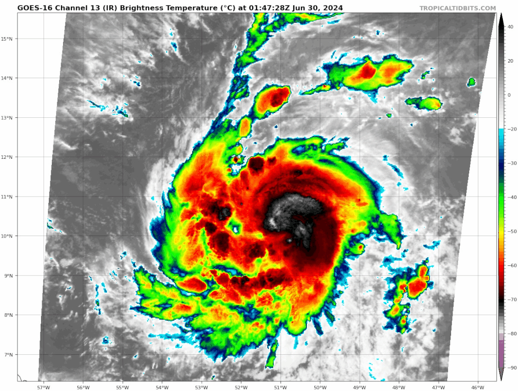
Beryl may be stronger than indicated at SSD dvorak.
A. 02L (BERYL)
B. 30/0000Z
C. 10.2N
D. 50.4W
E. ONE/GOES-E
F. T4.0/4.0
G. IR/EIR/SWIR
H. REMARKS...B EYE SURROUNDED BY W AND EMBEDDED IN LG RESULTS IN AN E# OF
5.0 WITH EADJ -1.0 FOR A DT OF 4.0. 2059Z SSMIS PASS SHOWS EYE AND NEARLY
CLOSED SOLID EYEWALL. TIGHT INNER CORE BANDING BECMG APPARENT. CLOUD TOPS
AS COLD AS -83 C. UPR-LVL OUTFLOW VERY GOOD NW AND W QUADS. MET=3.5 AND
PT=4.0. FT BASED ON DT. SYSTEM MAY BE STRONGER THAN FT INDICATES DUE TO
LIMITS OF DVORAK FOR SMALL TC.
I. ADDL POSITIONS
NIL
...KONON
1 likes
Visit the Caribbean-Central America Weather Thread where you can find at first post web cams,radars
and observations from Caribbean basin members Click Here
and observations from Caribbean basin members Click Here
-
ConvergenceZone
.gif)
- Category 5
- Posts: 5241
- Joined: Fri Jul 29, 2005 1:40 am
- Location: Northern California
Re: ATL: BERYL - Hurricane - Discussion
Man, can you imagine how busy and chaotic this board would be right now if this was expected to be a USA threat? This board would be going crazy right now! let's hope everyone in the islands will be okay and hopefully the shear in the Carib does a number on it, so that our friends in Belize etc will only get the rain.
Last edited by ConvergenceZone on Sat Jun 29, 2024 7:50 pm, edited 1 time in total.
4 likes
-
ColdMiser123

- Professional-Met

- Posts: 905
- Age: 29
- Joined: Mon Sep 26, 2016 3:26 pm
- Location: Northeast US
Re: ATL: BERYL - Hurricane - Discussion
ATCF now has 986 mb/75 kt for 0z
1 likes
B.S., M.S., Meteorology & Atmospheric Science
-
CrazyC83
- Professional-Met
- Posts: 34315
- Joined: Tue Mar 07, 2006 11:57 pm
- Location: Deep South, for the first time!
Re: ATL: BERYL - Hurricane - Discussion
cycloneye wrote:Beryl may be stronger than indicated at SSD dvorak.A. 02L (BERYL)
B. 30/0000Z
C. 10.2N
D. 50.4W
E. ONE/GOES-E
F. T4.0/4.0
G. IR/EIR/SWIR
H. REMARKS...B EYE SURROUNDED BY W AND EMBEDDED IN LG RESULTS IN AN E# OF
5.0 WITH EADJ -1.0 FOR A DT OF 4.0. 2059Z SSMIS PASS SHOWS EYE AND NEARLY
CLOSED SOLID EYEWALL. TIGHT INNER CORE BANDING BECMG APPARENT. CLOUD TOPS
AS COLD AS -83 C. UPR-LVL OUTFLOW VERY GOOD NW AND W QUADS. MET=3.5 AND
PT=4.0. FT BASED ON DT. SYSTEM MAY BE STRONGER THAN FT INDICATES DUE TO
LIMITS OF DVORAK FOR SMALL TC.
I. ADDL POSITIONS
NIL
...KONON
I would assess the intensity at 80 kt with all that data and turning off the constraints.
0 likes

Re: ATL: BERYL - Hurricane - Discussion
CrazyC83 wrote:cycloneye wrote:Beryl may be stronger than indicated at SSD dvorak.A. 02L (BERYL)
B. 30/0000Z
C. 10.2N
D. 50.4W
E. ONE/GOES-E
F. T4.0/4.0
G. IR/EIR/SWIR
H. REMARKS...B EYE SURROUNDED BY W AND EMBEDDED IN LG RESULTS IN AN E# OF
5.0 WITH EADJ -1.0 FOR A DT OF 4.0. 2059Z SSMIS PASS SHOWS EYE AND NEARLY
CLOSED SOLID EYEWALL. TIGHT INNER CORE BANDING BECMG APPARENT. CLOUD TOPS
AS COLD AS -83 C. UPR-LVL OUTFLOW VERY GOOD NW AND W QUADS. MET=3.5 AND
PT=4.0. FT BASED ON DT. SYSTEM MAY BE STRONGER THAN FT INDICATES DUE TO
LIMITS OF DVORAK FOR SMALL TC.
I. ADDL POSITIONS
NIL
...KONON
I would assess the intensity at 80 kt with all that data and turning off the constraints.
I can easily see that for the 11pm intensity, it's already 75kt on the BT and they had it at 60 prior to upgrading earlier.
0 likes
The above post is not official and should not be used as such. It is the opinion of the poster and may or may not be backed by sound meteorological data. It is not endorsed by any professional institution or storm2k.org. For official information, please refer to the NHC and NWS products.

-
Category5Kaiju

- Category 5
- Posts: 4326
- Joined: Thu Dec 24, 2020 12:45 pm
- Location: Seattle and Phoenix
Re: ATL: BERYL - Hurricane - Discussion
Captain Barbossa's Tropical Cyclone Timeline:
1. June 1st: Everyone is excited about the upcoming season. Many are anticipating upcoming action later in the month, but most know that the real action will most likely start in August.
2. June 29th: There's a major Caribbean cruising, Cape Verde hurricane that is active.

1. June 1st: Everyone is excited about the upcoming season. Many are anticipating upcoming action later in the month, but most know that the real action will most likely start in August.
2. June 29th: There's a major Caribbean cruising, Cape Verde hurricane that is active.
Last edited by Category5Kaiju on Sat Jun 29, 2024 8:32 pm, edited 2 times in total.
25 likes
Unless explicitly stated, all info in my posts is based on my own opinions and observations. Tropical storms and hurricanes can be extremely dangerous. Refer to an accredited weather research agency or meteorologist if you need to make serious decisions regarding an approaching storm.
-
ScottNAtlanta

- Category 5
- Posts: 2535
- Joined: Sat May 25, 2013 3:11 pm
- Location: Atlanta, GA
Re: ATL: BERYL - Hurricane - Discussion
UTSARoadrunner4 wrote:ScottNAtlanta wrote:HurricaneBelle wrote:Sure, we can call it Hurricane Beryl but to be economical we can just call it Berylcane
or Hurl Burl
Hurl-a-Beryl, the newest ride from the Atlantic Ocean theme park.
It spins really fast and the bottom drops out
1 likes
The posts in this forum are NOT official forecast and should not be used as such. They are just the opinion of the poster and may or may not be backed by sound meteorological data. They are NOT endorsed by any professional institution or storm2k.org. For official information, please refer to the NHC and NWS products.
-
cycloneye
- Admin
- Posts: 149214
- Age: 69
- Joined: Thu Oct 10, 2002 10:54 am
- Location: San Juan, Puerto Rico
Re: ATL: BERYL - Hurricane - Discussion
0 likes
Visit the Caribbean-Central America Weather Thread where you can find at first post web cams,radars
and observations from Caribbean basin members Click Here
and observations from Caribbean basin members Click Here
Re: ATL: BERYL - Hurricane - Discussion
Hints of the eye clearing out?
3 likes
TC naming lists: retirements and intensity
Most aggressive Advisory #1's in North Atlantic (cr. kevin for starting the list)
Most aggressive Advisory #1's in North Atlantic (cr. kevin for starting the list)
-
bob rulz
- Category 5
- Posts: 1711
- Age: 35
- Joined: Sat Jan 28, 2006 7:30 pm
- Location: Salt Lake City, Utah
Re: ATL: BERYL - Hurricane - Discussion
This is truly incredible. 2005 was the first year I would say I became a bit of a hurricane enthusiast. An unusually early Cape Verde hurricane that will likely enter the Caribbean at major hurricane intensity gives me big Emily 2005 vibes. On the one hand it's amazing to see this history being made, on the other hand it does not bode well for this hurricane season. Unfortunately it could end up being one for the ages.
4 likes


Re: ATL: BERYL - Hurricane - Discussion
ConvergenceZone wrote:Man, can you imagine how busy and chaotic this board would be right now if this was expected to be a USA threat? This board would be going crazy right now! let's hope everyone in the islands will be okay and hopefully the shear in the Carib does a number on it, so that our friends in Belize etc will only get the rain.
We are all most concerned with something that is threatening where we live. There are only a few of us Caribbean folks on here, so often the islands get overlooked.
I hope the people in Barbados, T and T, Grenada, St Vincent, St Lucia will be safe. Even a tropical storm in the fragile environment of the islands can cause damage. Flooding is a real threat.
8 likes
Too many hurricanes to remember
Re: ATL: BERYL - Hurricane - Discussion
In addition to being anomalously far east this time of the year, Beryl is also anomalously far south.
Another fun fact: See the short near-horizontal line in the MDR that appeared right next to Beryl 2024 and soon after it in the animation? That's Beryl 2018. It took a very similar track as this year's Beryl so far, and became a hurricane even further east, but a week later.
https://x.com/burgwx/status/1807177625389191290
https://x.com/burgwx/status/1807181475072319508
Last edited by Teban54 on Sat Jun 29, 2024 9:30 pm, edited 2 times in total.
2 likes
TC naming lists: retirements and intensity
Most aggressive Advisory #1's in North Atlantic (cr. kevin for starting the list)
Most aggressive Advisory #1's in North Atlantic (cr. kevin for starting the list)

Re: ATL: BERYL - Hurricane - Discussion
msbee wrote:ConvergenceZone wrote:Man, can you imagine how busy and chaotic this board would be right now if this was expected to be a USA threat? This board would be going crazy right now! let's hope everyone in the islands will be okay and hopefully the shear in the Carib does a number on it, so that our friends in Belize etc will only get the rain.
We are all most concerned with something that is threatening where we live. There are only a few of us Caribbean folks on here, so often the islands get overlooked.
I hope the people in Barbados, T and T, Grenada, St Vincent, St Lucia will be safe. Even a tropical storm in the fragile environment of the islands can cause damage. Flooding is a real threat.
Indeed. Plus in many of the islands we have had a lot of rain from the previous waves so some of our grounds are already saturated. We can often get caught up on windspeed but widespread flooding often does the bulk of the dirty work in these storms. As a reminder, Erika 2015 in Dominica.
Stay safe my fellow islanders and indeed everyone here on S2K. It looks like a long, arduous(and intriguing) season ahead.
8 likes
-
SconnieCane
- Category 5
- Posts: 1013
- Joined: Thu Aug 02, 2018 5:29 pm
- Location: Madison, WI
Re: ATL: BERYL - Hurricane - Discussion
I first really started tracking in earnest in the summer of 1994 (when I was 8). Ever since then, every six years like clockwork those familiar names have come up. Alberto, Beryl, Chris, Debby, Ernesto, Gordon...(2018 finally got rid of Florence). This particular list has had more staying power than most as it has consistently been associated with relatively benign seasons (or if there was a high-impact storm, it was further down the list such as Sandy of 2012 or Michael of 2018). This might be the year that changes that. 
Last edited by SconnieCane on Sat Jun 29, 2024 9:48 pm, edited 2 times in total.
3 likes
Who is online
Users browsing this forum: No registered users and 15 guests