ATL: BERYL - Post-Tropical - Discussion
Moderator: S2k Moderators
-
ElectricStorm

- Category 5

- Posts: 5127
- Age: 25
- Joined: Tue Aug 13, 2019 11:23 pm
- Location: Norman, OK
Re: ATL: BERYL - Hurricane - Discussion
Looks like it may have taken a gulp of dry air and the deepest convection now looks to be to the east of the center. I'd imagine it'll mix that out pretty quickly though.
0 likes
B.S Meteorology, University of Oklahoma '25
Please refer to the NHC, NWS, or SPC for official information.
Please refer to the NHC, NWS, or SPC for official information.

Re: ATL: BERYL - Hurricane - Discussion
ElectricStorm wrote:Looks like it may have taken a gulp of dry air and the deepest convection now looks to be to the east of the center. I'd imagine it'll mix that out pretty quickly though.
Was just about to ask the same question:

1 likes
TC naming lists: retirements and intensity
Most aggressive Advisory #1's in North Atlantic (cr. kevin for starting the list)
Most aggressive Advisory #1's in North Atlantic (cr. kevin for starting the list)

Re: ATL: BERYL - Hurricane - Discussion
This is absolute madness!
For the first time in a while, we may see a very significant early-alphabet storm, a big one with the letter B.
Sure goes to show that despite the calendar showing June 30, the Atlantic conditions are more set up like August 30. Major hurricane looks likely, as the NHC predict.

1 likes
Georges '98, Irene '99, Frances '04, Jeanne '04, Katrina '05, Wilma '05, Gustav '08, Isaac '12, Matthew '16, Florence '18, Michael '18, Ian '22


Re: ATL: BERYL - Hurricane - Discussion
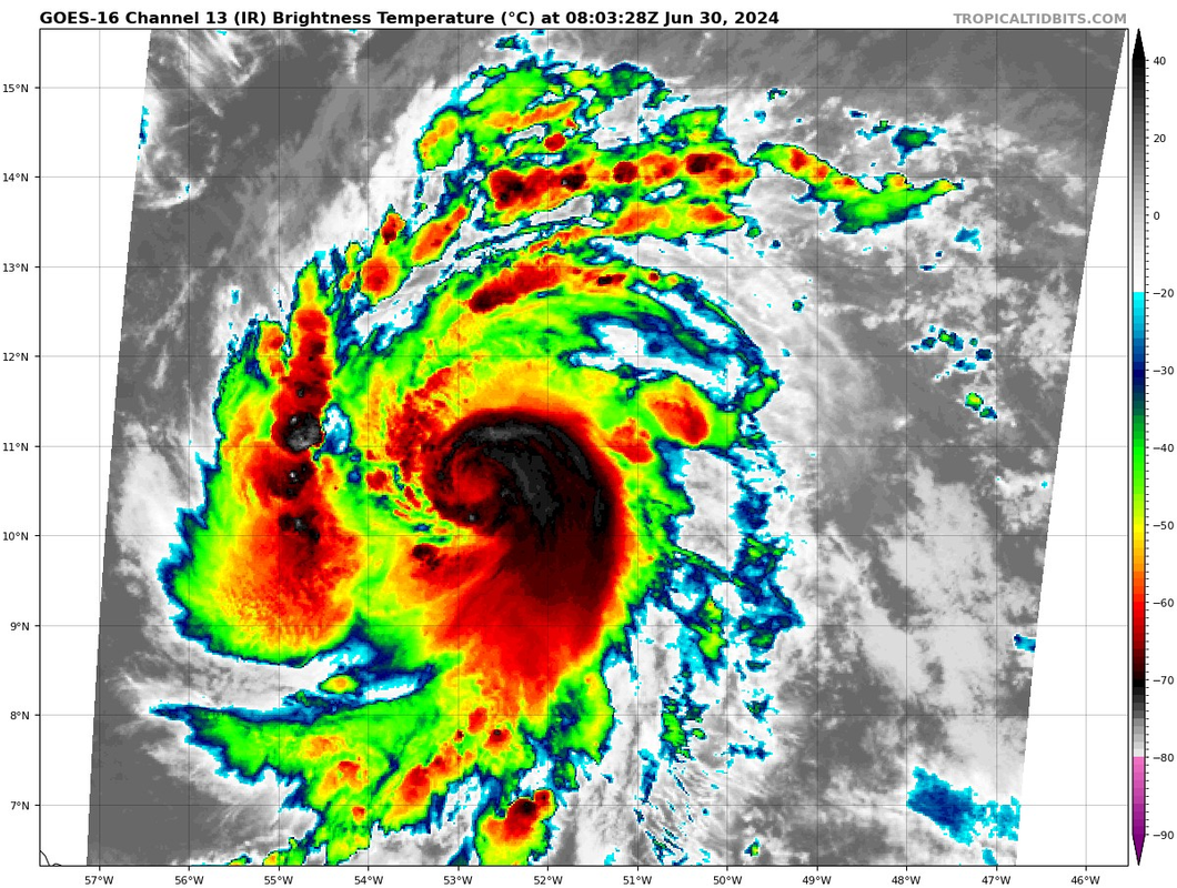
The cirrus outflow from the rotating eyewall hot tower is punching through the tropopause.
It is increasing in altitude as it progresses, building the eyewall.
Thus, it eclipses the warm-core's hot-spot seen on IR.
It is increasing in altitude as it progresses, building the eyewall.
Thus, it eclipses the warm-core's hot-spot seen on IR.
3 likes
Re: ATL: BERYL - Hurricane - Discussion
Beryl is now entraining the Amazon Basin's high TPW air.
50W, the traditional benchmark where AEW's / MDR TC's pick up a lot of steam.
https://tropic.ssec.wisc.edu/real-time/ ... latest.gif
50W, the traditional benchmark where AEW's / MDR TC's pick up a lot of steam.
https://tropic.ssec.wisc.edu/real-time/ ... latest.gif
0 likes
Re: ATL: BERYL - Hurricane - Discussion
ULL now formed 30N 53W. This was a TUTT yesterday.
Going to reinforce the poleward outflow channel for Beryl.
This may help reduce the "slight shear" and get Beryl more vertically stacked.
The enhanced outflow will allow the core's updraft to flow out higher in altitude.
Going to reinforce the poleward outflow channel for Beryl.
This may help reduce the "slight shear" and get Beryl more vertically stacked.
The enhanced outflow will allow the core's updraft to flow out higher in altitude.
3 likes
-
Hurrilurker

- Category 2

- Posts: 738
- Joined: Mon Jun 09, 2003 3:32 pm
- Location: San Francisco, CA
Re: ATL: BERYL - Hurricane - Discussion
I can't believe we'll be getting recon from the Atlantic in June, crazy.
Also, last IR frame looks like it might be forming "the fist"...
Also, last IR frame looks like it might be forming "the fist"...
Last edited by Hurrilurker on Sun Jun 30, 2024 3:05 am, edited 1 time in total.
0 likes
Re: ATL: BERYL - Hurricane - Discussion
GCANE wrote:ULL now formed 30N 53W. This was a TUTT yesterday.
Going to reinforce the poleward outflow channel for Beryl.
This may help reduce the "slight shear" and get Beryl more vertically stacked.
The enhanced outflow will allow the core's updraft to flow out higher in altitude.
Just noticed there is an anticyclonic wave break associated with the ULL centered at 20N 44W.
That will also help to reinforce the poleward outflow channel.
0 likes
Re: ATL: BERYL - Hurricane - Discussion
Shear dropping all around Beryl.
Clear path to the islands
https://tropic.ssec.wisc.edu/real-time/ ... oom=&time=
Clear path to the islands
https://tropic.ssec.wisc.edu/real-time/ ... oom=&time=
0 likes
Re: ATL: BERYL - Hurricane - Discussion
Feeder band rapidly developing along and mostly parallel to the SA shore
0 likes
Re: ATL: BERYL - Hurricane - Discussion
Quite a comeback from earlier:
2 likes
TC naming lists: retirements and intensity
Most aggressive Advisory #1's in North Atlantic (cr. kevin for starting the list)
Most aggressive Advisory #1's in North Atlantic (cr. kevin for starting the list)

Re: ATL: BERYL - Hurricane - Discussion
Hot towers in the last IR frames on both sides of the eyewall. Wouldn't be surprised if recon arrives while Beryl is in the process of clearing its eye.
0 likes
Re: ATL: BERYL - Hurricane - Discussion
First time I heard Levi use the term PV Streamer. I loved it.
So, I just checked the latest GFS 355K PV and Beryl will basically be pushing everything out of its way and creating what I call a PV ring.
https://www.tropicaltidbits.com/analysi ... 000&fh=102
Just about the worst-case scenario. TCs rapidly develop and maintain their strength in such an environment, other factors removed.
Sorry I can't sugar coat this.
At this point Berly will barrel straight to Texas.
Thing to watch is the ridge over the south CONUS and the possible UL trough, I have been talking about, which may erode the ridge.
Timing on that will be everything.
2 likes
Re: ATL: BERYL - Hurricane - Discussion
kevin wrote:Hot towers in the last IR frames on both sides of the eyewall. Wouldn't be surprised if recon arrives while Beryl is in the process of clearing its eye.
I think at some point this may be, or close to it, a pin hole
0 likes
Re: ATL: BERYL - Hurricane - Discussion
So, it looks like a strong Omega Block will be setup in the Bering Sea that will regress everything east of it including what is across the CONUS.
Looks like it could weaken that ridge across the southern CONUS.
I think the UL Trough I mentioned earlier is out of play.
Looks like it could weaken that ridge across the southern CONUS.
I think the UL Trough I mentioned earlier is out of play.
2 likes
Re: ATL: BERYL - Hurricane - Discussion
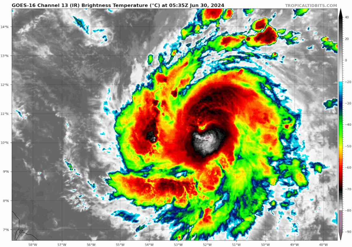
The enhanced venting from the poleward outflow channel will sweep out the cirrus from eyewall hot-towers in short order.
May see a nice eye on IR in short order and something on VIS a bit later.
May see a nice eye on IR in short order and something on VIS a bit later.
0 likes
Re: ATL: BERYL - Hurricane - Discussion
I don't think I have ever seen eyewall hot-towers develop that quickly.
0 likes
Re: ATL: BERYL - Hurricane - Discussion
Never seen an eye clear out on IR that fast before.
The venting really did the trick.
The venting really did the trick.
1 likes
Who is online
Users browsing this forum: No registered users and 16 guests