#1226 Postby JaxGator » Mon Jul 01, 2024 1:40 pm
Xyls wrote:CrazyC83 wrote:JaxGator wrote:
Depends on where/how strong the high pressure ridge is relative to the hurricane’s position. Same for troughs too. They can both prevent disaster (thank goodness) or if the timing is off, then yeah that would be a horrible no good, very bad day for somebody.
Northerly shear in a west-moving storm would likely weaken it significantly, if it holds up when Beryl arrives.
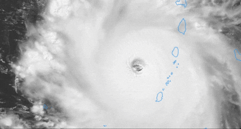
As for now, I would say the intensity is 135 kt, with a pressure of 942 mb, based on extrapolation of the previous data.
And this is the big question. Because looking at satellite it does look like that shear has been abating a bit in it's path.
Didn’t any model runs show the shear either moving in tandem with Beryl or was the shear forecast to relent and changed?
0 likes
The posts or stuff said are NOT an official forecast. Please look to the NHC and NWS for official forecasts and products.
Floyd-1999, Frances-2004, Jeanne-2004, Fay-2008, Beryl-2012, Debby-2012, Colin-2016, Hermine-2016, Julia-2016, Matthew-2016, Irma-2017, Elsa-2021, Idalia-2023, Debby-2024, Helene-2024.
Go Gators! Go Jags!


