AL, 02, 2024070206, , BEST, 0, 142N, 659W, 145, 935, HU, 34, NEQ, 110, 90, 50, 100, 1012, 150, 10, 0, 0, L, 0, , 0, 0, BERYL, D, 0, , 0, 0, 0, 0, genesis-num, 008,
ATL: BERYL - Post-Tropical - Discussion
Moderator: S2k Moderators
-
MississippiWx

- S2K Supporter

- Posts: 1720
- Joined: Sat Aug 14, 2010 1:44 pm
- Location: Hattiesburg, Mississippi
Re: ATL: BERYL - Hurricane - Discussion
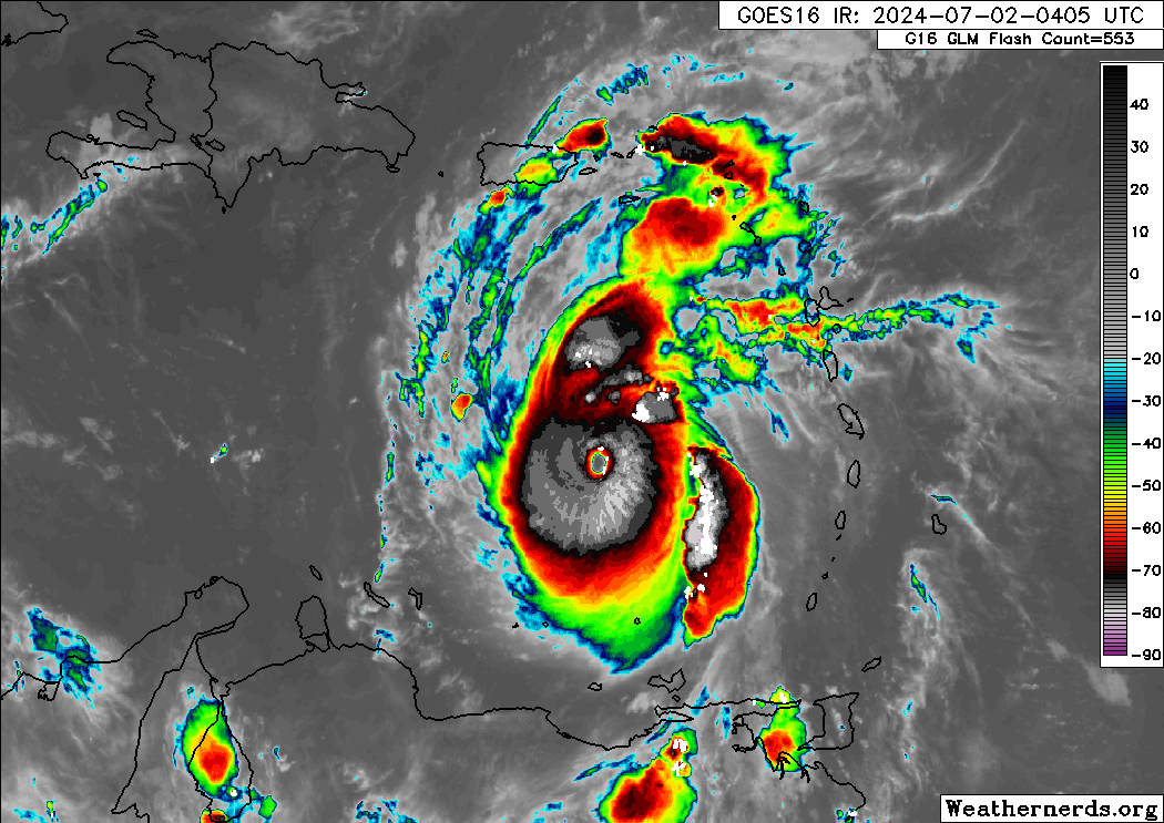
On infrared, this is probably the best Beryl has looked. Dvorak got a little ragged, but had made a comeback. Absolutely beautiful storm.
0 likes
This post is not an official forecast and should not be used as such. It is just the opinion of MississippiWx and may or may not be backed by sound meteorological data. It is not endorsed by any professional institution including storm2k.org. For Official Information please refer to the NHC and NWS products.

Re: ATL: BERYL - Hurricane - Discussion
What shocks me most isn't just that Beryl is a cat 5, but that it's such a consistent cat 5. Usually we are very afraid that recon will miss the peak of a storm by an hour or so (like before the previous Beryl recon). To get a cat 5, conditions need to be perfect and it usually only lasts a few short hours. And let's be honest often you need to be lucky that you have one pass with 156 kt FL instead of 152 kt FL. But Beryl has already been an operational cat 5 for 4 hours and only seems to improve more and more. It might've even been one for 10 hours or so based on IR trends. The point is, getting a cat 5 is an achievement already, but in hindsight we didn't have to worry about recon at all, there was plenty of time for it to find Beryl as a cat 5 monster.
10 likes
-
ElectricStorm

- Category 5

- Posts: 5157
- Age: 25
- Joined: Tue Aug 13, 2019 11:23 pm
- Location: Norman, OK
Re: ATL: BERYL - Hurricane - Discussion
ADT continues to climb, first raw 7.0 I've seen so far, and it's been consistently lower than recon data so far.
IR presentation also looks incredible right now, wouldn't surprise me if it's still intensifying.
UW - CIMSS
ADVANCED DVORAK TECHNIQUE
ADT-Version 9.1
Tropical Cyclone Intensity Algorithm
----- Current Analysis -----
Date : 02 JUL 2024 Time : 064021 UTC
Lat : 14:24:35 N Lon : 66:04:11 W
CI# /Pressure/ Vmax
6.9 / 931.2mb/137.4kt
Final T# Adj T# Raw T#
6.9 7.0 7.0
ADVANCED DVORAK TECHNIQUE
ADT-Version 9.1
Tropical Cyclone Intensity Algorithm
----- Current Analysis -----
Date : 02 JUL 2024 Time : 064021 UTC
Lat : 14:24:35 N Lon : 66:04:11 W
CI# /Pressure/ Vmax
6.9 / 931.2mb/137.4kt
Final T# Adj T# Raw T#
6.9 7.0 7.0
IR presentation also looks incredible right now, wouldn't surprise me if it's still intensifying.
4 likes
B.S Meteorology, University of Oklahoma '25
Please refer to the NHC, NWS, or SPC for official information.
Please refer to the NHC, NWS, or SPC for official information.
Re: ATL: BERYL - Hurricane - Discussion
Beryl is VIS/SWIR right now, textbook September July cat 5 Caribbean cruiser.

16 likes
Re: ATL: BERYL - Hurricane - Discussion
Jamaica’s only chance to avoid a very bad hit may be that shear between it and Beryl. So, that’s my hope to weaken it appreciably though it may not be enough to make much difference.
Unfortunately, when looking at analogous tracks with a solid speed of movement from the E or ESE at/near Jamaica, I’m kind of discouraged. These storms, 1951’s Charlie, 1974’s Carmen, 1988’s Gilbert, 2001’s Iris, 2004’s Charley and Ivan, 2005’s Dennis and Emily, and Dean of 2007 either only weakened slightly, were steady, or strengthened on the way to Jamaica. As strong as it already is, I doubt it will be stronger than what it is now but I’m concerned it may only weaken slightly at most based on these 9 analogs and still be a MH. Fingers crossed it will weaken substantially.
Unfortunately, when looking at analogous tracks with a solid speed of movement from the E or ESE at/near Jamaica, I’m kind of discouraged. These storms, 1951’s Charlie, 1974’s Carmen, 1988’s Gilbert, 2001’s Iris, 2004’s Charley and Ivan, 2005’s Dennis and Emily, and Dean of 2007 either only weakened slightly, were steady, or strengthened on the way to Jamaica. As strong as it already is, I doubt it will be stronger than what it is now but I’m concerned it may only weaken slightly at most based on these 9 analogs and still be a MH. Fingers crossed it will weaken substantially.
3 likes
Personal Forecast Disclaimer:
The posts in this forum are NOT official forecasts and should not be used as such. They are just the opinion of the poster and may or may not be backed by sound meteorological data. They are NOT endorsed by any professional institution or storm2k.org. For official information, please refer to the NHC and NWS products.
The posts in this forum are NOT official forecasts and should not be used as such. They are just the opinion of the poster and may or may not be backed by sound meteorological data. They are NOT endorsed by any professional institution or storm2k.org. For official information, please refer to the NHC and NWS products.

Re: ATL: BERYL - Hurricane - Discussion
LarryWx wrote: Jamaica’s only chance to avoid a very bad hit may be that shear between it and Beryl. So, that’s my hope to weaken it appreciably though it may not be enough to make much difference.
Unfortunately, when looking at analogous tracks with a solid speed of movement from the E or ESE at/near Jamaica, I’m kind of discouraged. These storms, 1951’s Charlie, 1974’s Carmen, 1988’s Gilbert, 2001’s Iris, 2004’s Charley and Ivan, 2005’s Dennis and Emily, and Dean of 2007 either only weakened slightly, were steady, or strengthened on the way to Jamaica. As strong as it already is, I doubt it will be stronger than what it is now but I’m concerned it may only weaken slightly at most based on these 9 analogs and still be a MH. Fingers crossed it will weaken substantially.
The NHC forecasts have been consistent over the last few days that conditions in the Caribbean Sea become less conducive from east to west and Beryl will weaken by a couple of categories by the time it reaches Jamaica. Having said that, they have consistently underestimated the peak intensity of this storm so far but it is very difficult to issue a forecast which blows climatology out of the water, the usual crowd would accuse them of over-hyping if they did and it busted.
5 likes
Re: ATL: BERYL - Hurricane - Discussion
Recon on its way again. Beryl's W-ring is still intact (with now even a sizable -75C region), but it is looking a little more ragged than before. Slight warming of cloud tops in general makes me think recon will find something in the 130 - 140 kt range now instead of 145 kt.
0 likes

Re: ATL: BERYL - Hurricane - Discussion
I can’t believe they actually pulled the trigger, let alone go with 145 kt.
You had a good run Emily lol.
You had a good run Emily lol.
1 likes
Irene '11 Sandy '12 Hermine '16 5/15/2018 Derecho Fay '20 Isaias '20 Elsa '21 Henri '21 Ida '21
I am only a meteorology enthusiast who knows a decent amount about tropical cyclones. Look to the professional mets, the NHC, or your local weather office for the best information.
I am only a meteorology enthusiast who knows a decent amount about tropical cyclones. Look to the professional mets, the NHC, or your local weather office for the best information.
-
Stormybajan

- Category 1

- Posts: 453
- Joined: Thu May 20, 2021 3:21 pm
- Location: Windward Islands
Re: ATL: BERYL - Hurricane - Discussion
I fell asleep when Beryl was announced as 155 mph, woke up randomly at 1 and saw she was now the earliest category 5 hurricane again at 160 mph breaking the record by a whole 15 DAYS THAT HURRICANE EMILY HELD FOR NEARLY 2 DECADES!! And I just assumed when I woke up at 5 am right now it wouldve been off her peak but noooooo Beryl wants to continue breaking all the records known to man in the Atlantic for July!! People look at the appearance of this monster, can she really do it and get to 175 mph???  I am DONE questioning Beryl and I am certainly not letting my guard down ever again this season, every single turning cloud I will be staring at like a madman from start to finish because this season could be one of those where everything spins up and becomes monsters , possibly even impactful monsters just like Hurricane Beryl did to the Grenadine islands.
Just look at her go!!
I am DONE questioning Beryl and I am certainly not letting my guard down ever again this season, every single turning cloud I will be staring at like a madman from start to finish because this season could be one of those where everything spins up and becomes monsters , possibly even impactful monsters just like Hurricane Beryl did to the Grenadine islands. Just look at her go!!
9 likes
Sad West Indies and Manchester United fan ⚽️
Re: ATL: BERYL - Hurricane - Discussion
Recon about 35 miles from the center and pressure is still at 1003 mb, extreme pressure gradient.
2 likes
Re: ATL: BERYL - Hurricane - Discussion
Clear double wind maximum in the northern quadrant. I suspected there was an upcoming EWRC due to a large convective blob on the north side of the CDO, as well as warming of said CDO.
0 likes
Irene '11 Sandy '12 Hermine '16 5/15/2018 Derecho Fay '20 Isaias '20 Elsa '21 Henri '21 Ida '21
I am only a meteorology enthusiast who knows a decent amount about tropical cyclones. Look to the professional mets, the NHC, or your local weather office for the best information.
I am only a meteorology enthusiast who knows a decent amount about tropical cyclones. Look to the professional mets, the NHC, or your local weather office for the best information.
-
Hurricane2022

- Category 5
- Posts: 2093
- Joined: Tue Aug 23, 2022 11:38 pm
- Location: Araçatuba, Brazil
Re: ATL: BERYL - Hurricane - Discussion
Cat 2 winds reported well away from the center, the holy EWRC is likely underway
0 likes
Sorry for the bad English sometimes...!
For reliable and detailed information for any meteorological phenomenon, please consult the National Hurricane Center, Joint Typhoon Warning Center , or your local Meteo Center.
--------
ECCE OMNIA NOVA FACIAM (Ap 21,5).
For reliable and detailed information for any meteorological phenomenon, please consult the National Hurricane Center, Joint Typhoon Warning Center , or your local Meteo Center.
--------
ECCE OMNIA NOVA FACIAM (Ap 21,5).
Re: ATL: BERYL - Hurricane - Discussion
165 kt SFMR and 164 kt FL winds! Wow, easy 150 or probably even 155 kt.
1 likes
-
Keldeo1997
- Category 2

- Posts: 688
- Joined: Fri Oct 11, 2019 11:35 pm
-
Charleswachal
- S2K Supporter
- Posts: 118
- Age: 35
- Joined: Tue Sep 27, 2022 11:24 pm
Re: ATL: BERYL - Hurricane - Discussion
165 knt surface winds!!!! This thing is trying to get to 200 mph winds!
0 likes
Tropical Systems Experienced... Hurricane Harvey 2017 (Houston); Tropical Depression Imelda 2019 (Houston); Hurricane Nicolas 2021 (Houston), Hurricane Beryl 2024 (Eye Intercept)
Re: ATL: BERYL - Hurricane - Discussion
Note that the flight level is 750mb, the conversion factor is around 0.86-0.87.
0 likes
Re: ATL: BERYL - Hurricane - Discussion
Even with the 0.87 conversion factor for FL winds, a blend of SFMR and FL supports 155 kt.
0 likes
Re: ATL: BERYL - Hurricane - Discussion
Ah yes, 160 kt FL and 165 kt SFMR in an Atlantic storm on July 2nd. That makes sense lol
4 likes
Irene '11 Sandy '12 Hermine '16 5/15/2018 Derecho Fay '20 Isaias '20 Elsa '21 Henri '21 Ida '21
I am only a meteorology enthusiast who knows a decent amount about tropical cyclones. Look to the professional mets, the NHC, or your local weather office for the best information.
I am only a meteorology enthusiast who knows a decent amount about tropical cyclones. Look to the professional mets, the NHC, or your local weather office for the best information.
-
Stormybajan
- Category 1
- Posts: 453
- Joined: Thu May 20, 2021 3:21 pm
- Location: Windward Islands
Re: ATL: BERYL - Hurricane - Discussion
Ummmm Did recon just record 155 knot support for Beryl just now?? Im dreaming right? I think I need a few more hours of sleep because I think im hallucinating. 

8 likes
Sad West Indies and Manchester United fan ⚽️
Who is online
Users browsing this forum: No registered users and 32 guests