ATL: BERYL - Post-Tropical - Discussion

Moderator: S2k Moderators

Message
Author
LearnedHat
Tropical Depression
Tropical Depression
Posts: 77
Joined: Wed Feb 10, 2010 11:17 am
Location: Keller, TX

Re: ATL: BERYL - Hurricane - Discussion Update: 11 AM advisory=160 mph

#1741 Postby LearnedHat » Tue Jul 02, 2024 10:45 am

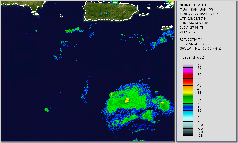
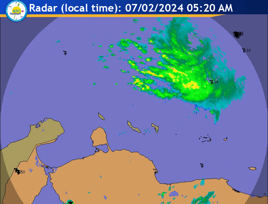
Hurrilurker wrote:Southern Texas could be in for at least a big rain event after all.


I know we would have to be weary of flash flooding and erosion damage but I hope some remnants can make it to the Hill Country. I would have to reach northward from a NE Mexico / S. Padre landfall about 300 miles for that to happen though. Don't need it to stall out - just pass over slowly (you know - as long as I am wishing).
4 likes   

BIFF_THE_UNRULY
Tropical Storm
Tropical Storm
Posts: 143
Joined: Fri Jun 28, 2024 2:12 pm

Re: ATL: BERYL - Hurricane - Discussion

#1742 Postby BIFF_THE_UNRULY » Tue Jul 02, 2024 10:52 am

storm_in_a_teacup wrote:
Michele B wrote:
Gums wrote:Salute from the Panhandle, aka Baja Alabama!

What's the feeling of those here with actual meteorology jobs/degees and long time victims/witnesses?

My theory has always been that early and especially strong storms reduce the energy content of the ocean or gulf by transfering that heat up into the stratosphere and or reducing the water temperature. For example, this very strong, well-developed thing should mitigate the new invest behind it, huh?

Of course El Nino conditions seem to reduce the number of storms and especially "major" ones, but we have seen that when having very high ocean temperatures and so-called climate change. But what's the feeling here aongst we storm folks.

Gums sends...


This is what I was thinking too!

Isn't Beryl having an effect on the ocean 96L is finding itself churning through?

Isn't there some "upwelling" that has cooled the ocean somewhat from Beryl's wake?


I’m under the impression that hurricanes mainly cool the ocean by mixing the warm surface water with the cool deeper water. I don’t think even they take enough heat to reduce the temperature noticeably just through the heat they extract.

But my expertise is black holes not hurricanes so you should probably still look this up. 8-)


I dont think the Caribbean is all that deep to have that effect, that would be true in the atlantic or pacific. Its just dang hot out and anything brought up from the depths will just warm up as quickly. If anything Beryl is plowing the road for the next one to be even worse.

But i am no Scientician. maybe there is an effect.
0 likes   

LarryWx
Category 5
Category 5
Posts: 6246
Joined: Sun Sep 07, 2003 2:04 pm
Location: GA

Re: ATL: BERYL - Hurricane - Discussion

#1743 Postby LarryWx » Tue Jul 02, 2024 10:59 am

storm_in_a_teacup wrote:
Michele B wrote:
Gums wrote:Salute from the Panhandle, aka Baja Alabama!

What's the feeling of those here with actual meteorology jobs/degees and long time victims/witnesses?

My theory has always been that early and especially strong storms reduce the energy content of the ocean or gulf by transfering that heat up into the stratosphere and or reducing the water temperature. For example, this very strong, well-developed thing should mitigate the new invest behind it, huh?

Of course El Nino conditions seem to reduce the number of storms and especially "major" ones, but we have seen that when having very high ocean temperatures and so-called climate change. But what's the feeling here aongst we storm folks.

Gums sends...


This is what I was thinking too!

Isn't Beryl having an effect on the ocean 96L is finding itself churning through?

Isn't there some "upwelling" that has cooled the ocean somewhat from Beryl's wake?


I’m under the impression that hurricanes mainly cool the ocean by mixing the warm surface water with the cool deeper water. I don’t think even they take enough heat to reduce the temperature noticeably just through the heat they extract.

But my expertise is black holes not hurricanes so you should probably still look this up. 8-)


I see it as a combination of heat being extracted from the warm waters to energize the storm and upwelling. Overall, TCs’ function is to bring up warmth from the tropics to further N to reduce the imbalance. If you look at SSTs shortly after strong storms traversing the open ocean, there almost always is a noticeable cool wake left behind within a couple of hundred miles of a storm center track. These cool wakes typically start to diminish and blend in with the surrounding waters within a couple of weeks.
Last edited by LarryWx on Tue Jul 02, 2024 11:02 am, edited 1 time in total.
1 likes   
Personal Forecast Disclaimer:
The posts in this forum are NOT official forecasts and should not be used as such. They are just the opinion of the poster and may or may not be backed by sound meteorological data. They are NOT endorsed by any professional institution or storm2k.org. For official information, please refer to the NHC and NWS products.

underthwx
Category 5
Category 5
Posts: 2351
Joined: Sat Jul 30, 2011 2:14 pm
Location: Brazoria County Texas

Re: ATL: BERYL - Hurricane - Discussion

#1744 Postby underthwx » Tue Jul 02, 2024 11:01 am

Teban54 wrote:Beryl's eye is visible (though just barely) on Puerto Rico radar and Curacao radar, as per Brian McNoldy's radar loops page. The first two links are auto-updated with the latest imagery. Here are the loops as of writing:
https://i.postimg.cc/c42xTny5/Beryl-2-Jul24-TJUA.gif
https://i.postimg.cc/bwnz5wqY/Beryl-2-Jul24-Curacao.gif

sup Teban?....thats an epic radar of Beryl....its cruising along at a fast pace...ig its the silver lining if there is one at all with the cyclone....at least it's moving quickly....hopefully a good thing...
1 likes   

LearnedHat
Tropical Depression
Tropical Depression
Posts: 77
Joined: Wed Feb 10, 2010 11:17 am
Location: Keller, TX

Re: ATL: BERYL - Hurricane - Discussion

#1745 Postby LearnedHat » Tue Jul 02, 2024 11:02 am

BIFF_THE_UNRULY wrote:
storm_in_a_teacup wrote:
Michele B wrote:
This is what I was thinking too!

Isn't Beryl having an effect on the ocean 96L is finding itself churning through?

Isn't there some "upwelling" that has cooled the ocean somewhat from Beryl's wake?


I’m under the impression that hurricanes mainly cool the ocean by mixing the warm surface water with the cool deeper water. I don’t think even they take enough heat to reduce the temperature noticeably just through the heat they extract.

But my expertise is black holes not hurricanes so you should probably still look this up. 8-)


I dont think the Caribbean is all that deep to have that effect, that would be true in the atlantic or pacific. Its just dang hot out and anything brought up from the depths will just warm up as quickly. If anything Beryl is plowing the road for the next one to be even worse.

But i am no Scientician. maybe there is an effect.


It's pretty deep --- I assume that ocean water temperature is used (along with existing wind and solar energy) by these systems and would think that more "stirring" would cool them off some if a very active season was compared to an inactive season ---- but I certainly haven't researched it like I have land based temperature records of Texas during the 20th century.
2 likes   

User avatar
Jonny
Tropical Depression
Tropical Depression
Posts: 81
Age: 37
Joined: Thu Aug 31, 2017 1:43 pm
Location: FL Panhandle

Re: ATL: BERYL - Hurricane - Discussion

#1746 Postby Jonny » Tue Jul 02, 2024 11:10 am

Is Beryl more likely to go through all of Jamaica vs the more southern portion?

What are the chances of her barely touching the Yucatán before entering the GOM?
2 likes   
Storm Track: Erin '95, Opal '95, Danny '97, Georges '98, Ivan '04, Dennis '05

User avatar
Kazmit
Category 5
Category 5
Posts: 2124
Age: 22
Joined: Mon Jul 25, 2016 8:49 am
Location: Williamsburg, VA / Bermuda

Re: ATL: BERYL - Hurricane - Discussion

#1747 Postby Kazmit » Tue Jul 02, 2024 11:10 am

LarryWx wrote:
storm_in_a_teacup wrote:
Michele B wrote:
This is what I was thinking too!

Isn't Beryl having an effect on the ocean 96L is finding itself churning through?

Isn't there some "upwelling" that has cooled the ocean somewhat from Beryl's wake?


I’m under the impression that hurricanes mainly cool the ocean by mixing the warm surface water with the cool deeper water. I don’t think even they take enough heat to reduce the temperature noticeably just through the heat they extract.

But my expertise is black holes not hurricanes so you should probably still look this up. 8-)


I see it as a combination of heat being extracted from the warm waters to energize the storm and upwelling. Overall, TCs’ function is to bring up warmth from the tropics to further N to reduce the imbalance. If you look at SSTs shortly after strong storms traversing the open ocean, there almost always is a noticeable cool wake left behind within a couple of hundred miles of a storm center track. These cool wakes typically start to diminish and blend in with the surrounding waters within a couple of weeks.

And with SSTs still warming up, Beryl's wake will be diminished at a faster rate than a peak-season equivalent storm.
5 likes   
Igor 2010, Sandy 2012, Fay 2014, Gonzalo 2014, Joaquin 2015, Nicole 2016, Humberto 2019

I am only a tropical weather enthusiast. My predictions are not official and may or may not be backed by sound meteorological data. For official information, please refer to the NHC and NWS products.

weatherdude1108
Category 5
Category 5
Posts: 4228
Joined: Tue Dec 13, 2011 1:04 pm
Location: Northwest Austin/Cedar Park, TX

Re: ATL: BERYL - Hurricane - Discussion

#1748 Postby weatherdude1108 » Tue Jul 02, 2024 11:15 am

I haven't seen any discussion on the news about how the Saharan dust plume may effect/potentially effect Beryl's intensity. I might have missed something. A lot of dry air with those plumes.
0 likes   
The preceding post is NOT an official forecast, and should not be used as such. It is only the opinion of the poster and may or may not be backed by sound meteorological data. It is NOT endorsed by any professional institution including storm2k.org. For Official Information please refer to the NHC and NWS products.

User avatar
Hypercane_Kyle
Category 5
Category 5
Posts: 3344
Joined: Sat Mar 07, 2015 7:58 pm
Location: Cape Canaveral, FL

Re: ATL: BERYL - Hurricane - Discussion

#1749 Postby Hypercane_Kyle » Tue Jul 02, 2024 11:17 am

weatherdude1108 wrote:I haven't seen any discussion on the news about how the Saharan dust plume may effect/potentially effect Beryl's intensity. I might have missed something. A lot of dry air with those plumes.


I mean, it wasn't enough to stop it from becoming a Category 5 when it was surrounded by SAL in the MDR...
12 likes   
My posts are my own personal opinion, defer to the National Hurricane Center (NHC) and other NOAA products for decision making during hurricane season.

Michele B
S2K Supporter
S2K Supporter
Posts: 1114
Joined: Thu Aug 25, 2016 8:08 am
Location: SWFL

Re: ATL: BERYL - Hurricane - Discussion Update: 11 AM advisory=160 mph

#1750 Postby Michele B » Tue Jul 02, 2024 11:31 am

AerospaceEng wrote:NHC with another pretty big shift North. Tough forecast. Belize is essentially out of the cone.


Oh, happy for them!
0 likes   
Cleo - 1964, Betsy - 1965, David - 1979, Andrew - 1992, Charlie (Francis, Ivan, Jeanne) - 2004, Irma - 2017, Ian - 2022

ChrisH-UK
Category 2
Category 2
Posts: 611
Joined: Sat May 29, 2021 8:22 am

Re: ATL: BERYL - Hurricane - Discussion

#1751 Postby ChrisH-UK » Tue Jul 02, 2024 11:34 am

Source GEOS-16 Red and Cloud Particle Blend - https://col.st/66jph

Image
1 likes   

User avatar
HurricaneBrain
S2K Supporter
S2K Supporter
Posts: 520
Joined: Thu Jun 30, 2011 2:07 pm

Re: ATL: BERYL - Hurricane - Discussion

#1752 Postby HurricaneBrain » Tue Jul 02, 2024 11:35 am

Ring closed off again in latest frame...
Image
2 likes   

Charleswachal
S2K Supporter
S2K Supporter
Posts: 118
Age: 34
Joined: Tue Sep 27, 2022 11:24 pm

Re: ATL: BERYL - Hurricane - Discussion

#1753 Postby Charleswachal » Tue Jul 02, 2024 11:35 am

So is this the weakening everybody has been talking about? Or is this just another eyewall replacement cycle?
1 likes   
Tropical Systems Experienced... Hurricane Harvey 2017 (Houston); Tropical Depression Imelda 2019 (Houston); Hurricane Nicolas 2021 (Houston), Hurricane Beryl 2024 (Eye Intercept)

Michele B
S2K Supporter
S2K Supporter
Posts: 1114
Joined: Thu Aug 25, 2016 8:08 am
Location: SWFL

Re: ATL: BERYL - Hurricane - Discussion

#1754 Postby Michele B » Tue Jul 02, 2024 11:35 am

weatherdude1108 wrote:I haven't seen any discussion on the news about how the Saharan dust plume may effect/potentially effect Beryl's intensity. I might have missed something. A lot of dry air with those plumes.


Yeah, I was surprised at her phenomenal growth/strength with the Saharan dust being in the air.

Seems to have had NO impact on her.
2 likes   
Cleo - 1964, Betsy - 1965, David - 1979, Andrew - 1992, Charlie (Francis, Ivan, Jeanne) - 2004, Irma - 2017, Ian - 2022

Michele B
S2K Supporter
S2K Supporter
Posts: 1114
Joined: Thu Aug 25, 2016 8:08 am
Location: SWFL

Re: ATL: BERYL - Hurricane - Discussion

#1755 Postby Michele B » Tue Jul 02, 2024 11:37 am

HurricaneBrain wrote:Ring closed off again in latest frame...
https://i.ibb.co/gWGXSs9/download.png


Western side seems to be "flattening" out.

Is this the shear they say will impact her?
0 likes   
Cleo - 1964, Betsy - 1965, David - 1979, Andrew - 1992, Charlie (Francis, Ivan, Jeanne) - 2004, Irma - 2017, Ian - 2022

User avatar
Kazmit
Category 5
Category 5
Posts: 2124
Age: 22
Joined: Mon Jul 25, 2016 8:49 am
Location: Williamsburg, VA / Bermuda

Re: ATL: BERYL - Hurricane - Discussion

#1756 Postby Kazmit » Tue Jul 02, 2024 11:37 am

Anyone know of a record for maximum forward speed of a cat 5? I wonder if Beryl has that too.
1 likes   
Igor 2010, Sandy 2012, Fay 2014, Gonzalo 2014, Joaquin 2015, Nicole 2016, Humberto 2019

I am only a tropical weather enthusiast. My predictions are not official and may or may not be backed by sound meteorological data. For official information, please refer to the NHC and NWS products.

Sciencerocks
Category 5
Category 5
Posts: 8903
Age: 39
Joined: Thu Jul 06, 2017 1:51 am

Re: ATL: BERYL - Hurricane - Discussion

#1757 Postby Sciencerocks » Tue Jul 02, 2024 11:39 am

Image
1 likes   

User avatar
Blinhart
Category 5
Category 5
Posts: 2079
Age: 48
Joined: Thu Sep 08, 2011 3:13 pm
Location: Crowley, La.

Re: ATL: BERYL - Hurricane - Discussion

#1758 Postby Blinhart » Tue Jul 02, 2024 11:44 am

Just checked the Weather Channel forecast for here in Crowley, La., they haven't changed the forecast yet for us, still only around 58% chance of rain in a week with light wind, I would of expected them to up the rain chance some since it looks like we will be getting at least tropical rain showers in a week or so.
0 likes   
Personal Forecast Disclaimer:
The posts in this forum are NOT official forecast and should not be used as such. They are just the opinion of the poster and may or may not be backed by sound meteorological data. They are NOT endorsed by any professional institution or storm2k.org. For official information, please refer to the NHC and NWS products.

Charleswachal
S2K Supporter
S2K Supporter
Posts: 118
Age: 34
Joined: Tue Sep 27, 2022 11:24 pm

Re: ATL: BERYL - Hurricane - Discussion

#1759 Postby Charleswachal » Tue Jul 02, 2024 11:53 am

Recon is still showing 135 knots surface winds. And pressure still looks to be maybe 1 mb high higher
0 likes   
Tropical Systems Experienced... Hurricane Harvey 2017 (Houston); Tropical Depression Imelda 2019 (Houston); Hurricane Nicolas 2021 (Houston), Hurricane Beryl 2024 (Eye Intercept)

User avatar
jasons2k
Storm2k Executive
Storm2k Executive
Posts: 8238
Age: 51
Joined: Wed Jul 06, 2005 12:32 pm
Location: The Woodlands, TX

Re: ATL: BERYL - Hurricane - Discussion

#1760 Postby jasons2k » Tue Jul 02, 2024 11:56 am

An observation in Hi-Res satellite loops (sorry for the low-res version below):

The convection out ahead of the storm, in front of the eyewall and CDO, is not getting sheared. I have circled the blowup convection that’s not getting sheared apart. Also, the NW eyewall appears to have beefed-up in the last several images.

This tells me Beryl still has a ways to go before seeing significant shear impacts.

Zooming further out, the bands out to the west and northwest are getting sheared apart but time will tell how much Beryl catches up to it.

Image
6 likes   


Return to “2024”

Who is online

Users browsing this forum: Google Adsense [Bot] and 21 guests