ATL: BERYL - Post-Tropical - Discussion

Moderator: S2k Moderators

Message
Author
LearnedHat
Tropical Depression
Tropical Depression
Posts: 77
Joined: Wed Feb 10, 2010 11:17 am
Location: Keller, TX

Re: ATL: BERYL - Hurricane - Discussion

#1761 Postby LearnedHat » Tue Jul 02, 2024 12:02 pm

jasons2k wrote:An observation in Hi-Res satellite loops (sorry for the low-res version below):

The convection out ahead of the storm, in front of the eyewall and CDO, is not getting sheared. I have circled the blowup convection that’s not getting sheared apart. Also, the NW eyewall appears to have beefed-up in the last several images.

This tells me Beryl still has a ways to go before seeing significant shear impacts.

Zooming further out, the bands out to the west and northwest are getting sheared apart but time will tell how much Beryl catches up to it.

https://uploads.tapatalk-cdn.com/20240702/e99ebf8afce5a112f1cf4e1bec096ec0.jpg


Would we see any tilt start to happen in the eye (eye column) itself?
0 likes   

User avatar
kevin
Category 5
Category 5
Posts: 2554
Age: 26
Joined: Wed Aug 28, 2019 4:35 am

Re: ATL: BERYL - Hurricane - Discussion

#1762 Postby kevin » Tue Jul 02, 2024 12:04 pm

Everytime you think Beryl is really weakening, it suddenly starts reorganizing again. For such a traditionally hostile environment it's one of the most resilient TCs I've seen.
8 likes   

User avatar
cycloneye
Admin
Admin
Posts: 143883
Age: 68
Joined: Thu Oct 10, 2002 10:54 am
Location: San Juan, Puerto Rico

Re: ATL: BERYL - Hurricane - Discussion

#1763 Postby cycloneye » Tue Jul 02, 2024 12:08 pm

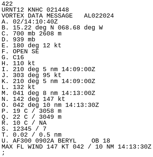
Per VDM, the eye is again closed at peak wind of 143kt.
1 likes   
Visit the Caribbean-Central America Weather Thread where you can find at first post web cams,radars
and observations from Caribbean basin members Click Here

User avatar
Jr0d
S2K Supporter
S2K Supporter
Posts: 1394
Joined: Tue Aug 27, 2019 10:52 am
Location: Cayo Hueso

Re: ATL: BERYL - Hurricane - Discussion

#1764 Postby Jr0d » Tue Jul 02, 2024 12:09 pm

It does appear to be feeling shear as the western side is being eroded, yet somehow it is still managing to keep the eyewall.

Let's hope the shear wins soon and Jamaica will see a significantly weaker storm without an intact eyewall.

Unfortunately as we saw with Katrina, the surge likely will still be extreme even with a significantly weaker storm as the wave action from her time as a monster will follow her across the Caribbean.
2 likes   

bohai
Tropical Depression
Tropical Depression
Posts: 76
Age: 65
Joined: Tue Jun 02, 2020 12:57 pm
Location: Comfort, TX

Re: ATL: BERYL - Hurricane - Discussion

#1765 Postby bohai » Tue Jul 02, 2024 12:13 pm

Kazmit wrote:
LarryWx wrote:
storm_in_a_teacup wrote:
I’m under the impression that hurricanes mainly cool the ocean by mixing the warm surface water with the cool deeper water. I don’t think even they take enough heat to reduce the temperature noticeably just through the heat they extract.

But my expertise is black holes not hurricanes so you should probably still look this up. 8-)


I see it as a combination of heat being extracted from the warm waters to energize the storm and upwelling. Overall, TCs’ function is to bring up warmth from the tropics to further N to reduce the imbalance. If you look at SSTs shortly after strong storms traversing the open ocean, there almost always is a noticeable cool wake left behind within a couple of hundred miles of a storm center track. These cool wakes typically start to diminish and blend in with the surrounding waters within a couple of weeks.

And with SSTs still warming up, Beryl's wake will be diminished at a faster rate than a peak-season equivalent storm.


Ironically, the sea surface temps warm up whereas the deeper depths remain pretty much status quo year round. At between 500 and 600m teseat water ambient temp approaches 5C and stays there as you get deeper. I worked on some offshore wells that were at 3000m BMSL and the temp was 4.5 C Its all depends on how deep the sunlight can penetrate. Here is a link to a white paper regarding such. https://geo.gcoos.org/data/ssha/ssha_ts_proflies.pdf
2 likes   

User avatar
MONTEGUT_LA
Tropical Storm
Tropical Storm
Posts: 105
Joined: Sun Jul 20, 2003 7:29 pm
Location: Montegut, Louisiana

Re: ATL: BERYL - Hurricane - Discussion

#1766 Postby MONTEGUT_LA » Tue Jul 02, 2024 12:17 pm

kevin wrote:Everytime you think Beryl is really weakening, it suddenly starts reorganizing again. For such a traditionally hostile environment it's one of the most resilient TCs I've seen.


I'm pretty sure Beryl will be studied to determine what was the driving factor. What caused her to survive in such a hostile environment? I feel like Beryl will be the talk of the Tropics for a long time. Hopefully, she is an isolated incident and not a precedent to what is to come later in the season.
3 likes   
::::::Danny & Juan '85, Andrew '92, Lili '02, Katrina & Rita '05, Gustav & Ike '08, Isaac '12, Ida 2021::::::

::::It's been a wild ride, but you just gotta love living on the gulf coast!::::

shansgonefishin
Tropical Low
Tropical Low
Posts: 13
Joined: Fri Aug 28, 2020 6:44 am

Re: ATL: BERYL - Hurricane - Discussion

#1767 Postby shansgonefishin » Tue Jul 02, 2024 12:21 pm

MGC wrote:Beryl's slow decay has started. Looks like a moat it starting to form around the hurricane. Another EWC commencing? Jamaica is clearly in Beryl's crosshairs......MGC


It feels much the same here on Grand Cayman, anything from a Cat 2 to a 4 at this stage…
1 likes   

User avatar
aspen
Category 5
Category 5
Posts: 8812
Joined: Sat Oct 12, 2019 7:10 pm
Location: Connecticut, USA

Re: ATL: BERYL - Hurricane - Discussion

#1768 Postby aspen » Tue Jul 02, 2024 12:23 pm

Looks like it’s weakened down to 135 kt now. Still quite impressive, but who knows how long it’ll maintain Cat 4 status or how badly shear will weaken it. Some of the hurricane model runs show Beryl getting absolutely obliterated tomorrow into Thursday.
0 likes   
Irene '11 Sandy '12 Hermine '16 5/15/2018 Derecho Fay '20 Isaias '20 Elsa '21 Henri '21 Ida '21

I am only a meteorology enthusiast who knows a decent amount about tropical cyclones. Look to the professional mets, the NHC, or your local weather office for the best information.

User avatar
ElectricStorm
Category 5
Category 5
Posts: 5017
Age: 24
Joined: Tue Aug 13, 2019 11:23 pm
Location: Skiatook, OK / Norman, OK

Re: ATL: BERYL - Hurricane - Discussion

#1769 Postby ElectricStorm » Tue Jul 02, 2024 12:24 pm

I'd probably go with 135kts/942mb for current intensity based on the last pass however cloud tops are cooling once again so it wouldn't surprise me if it strengthens a little. No double wind max so it doesn't appear there's any imminent EWRCs. Starting to get very concerned for Jamaica though.
2 likes   
I am in no way a professional. Take what I say with a grain of salt as I could be totally wrong. Please refer to the NHC, NWS, or SPC for official information.

Boomer Sooner!

IsabelaWeather
Category 1
Category 1
Posts: 287
Age: 35
Joined: Tue Jul 07, 2020 7:29 am
Location: Isabela, Puerto Rico

Re: ATL: BERYL - Hurricane - Discussion

#1770 Postby IsabelaWeather » Tue Jul 02, 2024 12:25 pm

underthwx wrote:CE?....looking at satellite imagery of Beryl....looks like a healthy band of weather over yall there in Puerto Rico....is that tropical storm conditions?...it looks like Beryl is moving a bit more north than previously?...


Why would there be tropical storm force winds here? SJ was like 300 miles from the storm at the closest approach, The south side got some decent gusts but even there not tropical storm force winds.

There hasnt even been much rain, except for the extreme SW part of the island.
1 likes   

underthwx
Category 5
Category 5
Posts: 2351
Joined: Sat Jul 30, 2011 2:14 pm
Location: Brazoria County Texas

Re: ATL: BERYL - Hurricane - Discussion

#1771 Postby underthwx » Tue Jul 02, 2024 12:49 pm

IsabelaWeather wrote:
underthwx wrote:CE?....looking at satellite imagery of Beryl....looks like a healthy band of weather over yall there in Puerto Rico....is that tropical storm conditions?...it looks like Beryl is moving a bit more north than previously?...


Why would there be tropical storm force winds here? SJ was like 300 miles from the storm at the closest approach, The south side got some decent gusts but even there not tropical storm force winds.

There hasnt even been much rain, except for the extreme SW part of the island.

I meant no harm....it was just a general question for my friend CE....
3 likes   

User avatar
Jr0d
S2K Supporter
S2K Supporter
Posts: 1394
Joined: Tue Aug 27, 2019 10:52 am
Location: Cayo Hueso

Re: ATL: BERYL - Hurricane - Discussion

#1772 Postby Jr0d » Tue Jul 02, 2024 12:56 pm

ElectricStorm wrote:I'd probably go with 135kts/942mb for current intensity based on the last pass however cloud tops are cooling once again so it wouldn't surprise me if it strengthens a little. No double wind max so it doesn't appear there's any imminent EWRCs. Starting to get very concerned for Jamaica though.


Beryl is on a weakening trend. Probably will have an open eye wall in 6 hours. This is better for Jamaica. The surge will be a major issue, the exposed bays will see the worst. Fortunately the elevation makes it easy to find high ground... unfortunately the higher elevations will see higher winds and the threat of landslides is present. The fast motion however should limit some freshwater flooding.
1 likes   

User avatar
Blinhart
Category 5
Category 5
Posts: 2079
Age: 48
Joined: Thu Sep 08, 2011 3:13 pm
Location: Crowley, La.

Re: ATL: BERYL - Hurricane - Discussion

#1773 Postby Blinhart » Tue Jul 02, 2024 12:57 pm

Jr0d wrote:
ElectricStorm wrote:I'd probably go with 135kts/942mb for current intensity based on the last pass however cloud tops are cooling once again so it wouldn't surprise me if it strengthens a little. No double wind max so it doesn't appear there's any imminent EWRCs. Starting to get very concerned for Jamaica though.


Beryl is on a weakening trend. Probably will have an open eye wall in 6 hours. This is better for Jamaica. The surge will be a major issue, the exposed bays will see the worst. Fortunately the elevation makes it easy to find high ground... unfortunately the higher elevations will see higher winds and the threat of landslides is present. The fast motion however should limit some freshwater flooding.


Where do you see it weakening and getting an open eye wall??? Looks to me she is staying steady if not strengthening back up.
0 likes   
Personal Forecast Disclaimer:
The posts in this forum are NOT official forecast and should not be used as such. They are just the opinion of the poster and may or may not be backed by sound meteorological data. They are NOT endorsed by any professional institution or storm2k.org. For official information, please refer to the NHC and NWS products.

Charleswachal
S2K Supporter
S2K Supporter
Posts: 118
Age: 34
Joined: Tue Sep 27, 2022 11:24 pm

Re: ATL: BERYL - Hurricane - Discussion

#1774 Postby Charleswachal » Tue Jul 02, 2024 12:58 pm

Jr0d wrote:
ElectricStorm wrote:I'd probably go with 135kts/942mb for current intensity based on the last pass however cloud tops are cooling once again so it wouldn't surprise me if it strengthens a little. No double wind max so it doesn't appear there's any imminent EWRCs. Starting to get very concerned for Jamaica though.


Beryl is on a weakening trend. Probably will have an open eye wall in 6 hours. This is better for Jamaica. The surge will be a major issue, the exposed bays will see the worst. Fortunately the elevation makes it easy to find high ground... unfortunately the higher elevations will see higher winds and the threat of landslides is present. The fast motion however should limit some freshwater flooding.


One of the computer models shows that staying as category 4 strengths all the way to Jamaica. Plus it shows it's staying At least a category 3 all the way until it gets to the Yucatan
2 likes   
Tropical Systems Experienced... Hurricane Harvey 2017 (Houston); Tropical Depression Imelda 2019 (Houston); Hurricane Nicolas 2021 (Houston), Hurricane Beryl 2024 (Eye Intercept)

IsabelaWeather
Category 1
Category 1
Posts: 287
Age: 35
Joined: Tue Jul 07, 2020 7:29 am
Location: Isabela, Puerto Rico

Re: ATL: BERYL - Hurricane - Discussion

#1775 Postby IsabelaWeather » Tue Jul 02, 2024 1:01 pm

underthwx wrote:
IsabelaWeather wrote:
underthwx wrote:CE?....looking at satellite imagery of Beryl....looks like a healthy band of weather over yall there in Puerto Rico....is that tropical storm conditions?...it looks like Beryl is moving a bit more north than previously?...


Why would there be tropical storm force winds here? SJ was like 300 miles from the storm at the closest approach, The south side got some decent gusts but even there not tropical storm force winds.

There hasnt even been much rain, except for the extreme SW part of the island.

I meant no harm....it was just a general question for my friend CE....


Nor I, I was just curious as to why you'd have expected tropical storm conditions. No need to answer, I was just letting you know I wasnt trying to be snarky.
2 likes   

USTropics
Category 5
Category 5
Posts: 2636
Joined: Sun Aug 12, 2007 3:45 am
Location: Florida State University

Re: ATL: BERYL - Hurricane - Discussion Update: 11 AM advisory=160 mph

#1776 Postby USTropics » Tue Jul 02, 2024 1:14 pm

LarryWx wrote:
Teban54 wrote:
USTropics wrote:
Here are all major hurricane storm tracks going back to 1850 that have either directly impacted Jamaica or came within ~50 miles of the island. The last direct landfalling major hurricane was Gilbert in 1988:
https://i.imgur.com/qiSICWy.png

I recall some people saying strong TCs often have a tendency to "bounce off" Jamaica and other land masses unexpectedly. Ivan was typically the justification given: it was initially forecast to landfall directly on Jamaica, but eventually skirted to the SW (albeit still causing heavy damages to the island).

I've always wondered whether such claims have any truth behind them, or if it was simply a manifest of poorer forecast skills in 2004 compared to now. What do we think are the chances that this happens again with Beryl?


Looking at MHs approaching Jamaica from the ESE, I’d say there’s no bouncing off tendency. Ivan of 2004’s track makes it appear that way but it may have been due to a new steering current happening to cause a change in heading from WNW to W right at Jamaica (a new high?). Anyone know? If not, I’d have to research that further. Dean of 2007 was already heading just S. So, that didn’t bounce off. Gilbert (1988), Charlie (1951), Storm #4 of 1944, and Storm #2 of 1903 didn’t bounce at all as they went straight across the island with no appreciable heading change.

So, at most, only one of six MAY have “bounced”, but even saying it changed heading due to Jamaica is highly questionable imo pending further analysis.


Yea the erratic track was more due to a breakdown of steering currents and an imminent EWRC. From the post analysis of Ivan:

Although a large subtropical ridge to the north remained intact, steering currents weakened and Ivan’s forward speed decreased to less than 10 kt on 11 September while the hurricane made a turn to the west, keeping the center at least 20 n mi offshore the southern coast of the island. As Ivan passed south of Jamaica it weakened to category 4 strength, in part, due to an eyewall replacement or concentric eyewall cycle (Fig. 4a). The combination of the westward turn and weakening kept the strongest winds offshore.
1 likes   

User avatar
Iceresistance
Category 5
Category 5
Posts: 9280
Age: 21
Joined: Sat Oct 10, 2020 9:45 am
Location: Tecumseh, OK/Norman, OK

Re: ATL: BERYL - Hurricane - Discussion

#1777 Postby Iceresistance » Tue Jul 02, 2024 1:14 pm

Blinhart wrote:
Jr0d wrote:
ElectricStorm wrote:I'd probably go with 135kts/942mb for current intensity based on the last pass however cloud tops are cooling once again so it wouldn't surprise me if it strengthens a little. No double wind max so it doesn't appear there's any imminent EWRCs. Starting to get very concerned for Jamaica though.


Beryl is on a weakening trend. Probably will have an open eye wall in 6 hours. This is better for Jamaica. The surge will be a major issue, the exposed bays will see the worst. Fortunately the elevation makes it easy to find high ground... unfortunately the higher elevations will see higher winds and the threat of landslides is present. The fast motion however should limit some freshwater flooding.


Where do you see it weakening and getting an open eye wall??? Looks to me she is staying steady if not strengthening back up.


Beryl is being sheared right now, plus there was a VDM that showed that the eye was "OPEN SE" earlier this morning.
Image
https://s12.gifyu.com/images/SryvO.png
Last edited by Iceresistance on Tue Jul 02, 2024 1:15 pm, edited 1 time in total.
0 likes   
Bill 2015 & Beta 2020

Winter 2020-2021 :cold:

All observations are in Tecumseh, OK unless otherwise noted.

Winter posts are focused mainly for Oklahoma & Texas.

Take any of my forecasts with a grain of salt, refer to the NWS, SPC, and NHC for official information

Never say Never with weather! Because ANYTHING is possible!

underthwx
Category 5
Category 5
Posts: 2351
Joined: Sat Jul 30, 2011 2:14 pm
Location: Brazoria County Texas

Re: ATL: BERYL - Hurricane - Discussion

#1778 Postby underthwx » Tue Jul 02, 2024 1:14 pm

IsabelaWeather wrote:
underthwx wrote:
IsabelaWeather wrote:
Why would there be tropical storm force winds here? SJ was like 300 miles from the storm at the closest approach, The south side got some decent gusts but even there not tropical storm force winds.

There hasnt even been much rain, except for the extreme SW part of the island.

I meant no harm....it was just a general question for my friend CE....


Nor I, I was just curious as to why you'd have expected tropical storm conditions. No need to answer, I was just letting you know I wasnt trying to be snarky.

I expected nada....it was only a question for my bro....its all good....peace
0 likes   

User avatar
Teban54
Category 5
Category 5
Posts: 3168
Joined: Sat May 19, 2018 1:19 pm

Re: ATL: BERYL - Hurricane - Discussion

#1779 Postby Teban54 » Tue Jul 02, 2024 1:15 pm

Iceresistance wrote:
Blinhart wrote:
Jr0d wrote:
Beryl is on a weakening trend. Probably will have an open eye wall in 6 hours. This is better for Jamaica. The surge will be a major issue, the exposed bays will see the worst. Fortunately the elevation makes it easy to find high ground... unfortunately the higher elevations will see higher winds and the threat of landslides is present. The fast motion however should limit some freshwater flooding.


Where do you see it weakening and getting an open eye wall??? Looks to me she is staying steady if not strengthening back up.


Beryl is being sheared right now, plus there was a VDM that showed that the eye was "OPEN SE" earlier this morning.
https://s12.gifyu.com/images/SryvO.png

The eyewall is now closed again, though:

556
URNT12 KNHC 021657
VORTEX DATA MESSAGE AL022024
A. 02/16:31:20Z
B. 15.47 deg N 069.45 deg W
C. 700 mb 2627 m
D. 944 mb
E. 170 deg 15 kt
F. CLOSED
G. C13
H. 135 kt
I. 344 deg 8 nm 16:29:00Z
J. 064 deg 143 kt
K. 335 deg 9 nm 16:28:00Z
L. 134 kt
M. 062 deg 8 nm 16:34:00Z
N. 154 deg 141 kt
O. 059 deg 10 nm 16:34:30Z
P. 9 C / 3049 m
Q. 20 C / 3042 m
R. 11 C / NA
S. 12345 / 7
T. 0.02 / 0.5 nm
U. AF300 0902A BERYL OB 26
MAX FL WIND 143 KT 335 / 9 NM 16:28:00Z
;
1 likes   

User avatar
weatherman2004
Tropical Wave
Tropical Wave
Posts: 3
Joined: Tue Jul 02, 2024 8:50 am

Re: ATL: BERYL - Hurricane - Discussion

#1780 Postby weatherman2004 » Tue Jul 02, 2024 1:15 pm

First time posting here. It is my opinion, that yes it went back down to CAT 4 with 943 pressure, but it seems that the cloud tops are getting spicy again in the eye wall via satellite. Will be interesting to see if the sheer can open it up, either way Jamaica and wherever else this beast goes is going to be in a whole lot of trouble. Long range, I do not think we will know what is going to happen until it passes up this sheer, and the course it takes after Jamaica. The HWRF's newest model is quite interesting with the intensity it keeps, then strengthens after hitting Jamaica hitting Cozumel as a major hurricane. One of the craziest storms I have seen, due to the region it is in. I do think that a EWRC is going to happen sooner then later.
2 likes   


Return to “2024”

Who is online

Users browsing this forum: No registered users and 26 guests