ATL: BERYL - Post-Tropical - Discussion
Moderator: S2k Moderators

Re: ATL: BERYL - Hurricane - Discussion
Looks like the forecast tack has been adjusted to the north.
5 likes
-
jconsor
- Professional-Met

- Posts: 581
- Joined: Mon Jun 30, 2008 9:31 pm
- Location: Jerusalem, Israel
- Contact:
Re: ATL: BERYL - Hurricane - Discussion
Thank you! Appreciate your insightful posts as well.
ColdMiser123 wrote:jconsor wrote:Thread on important short-term trends noted regarding Beryl, and how this influences her potential TX/MX impacts.
https://x.com/yconsor/status/1808853711629746332
Great writeup - lots of fantastic points made in this thread.
6 likes
-
ScottNAtlanta

- Category 5

- Posts: 2535
- Joined: Sat May 25, 2013 3:11 pm
- Location: Atlanta, GA
Re: ATL: BERYL - Hurricane - Discussion
If it keeps going in the same direction it is going now, it will cross the Yucatan well north of 20 degrees
0 likes
The posts in this forum are NOT official forecast and should not be used as such. They are just the opinion of the poster and may or may not be backed by sound meteorological data. They are NOT endorsed by any professional institution or storm2k.org. For official information, please refer to the NHC and NWS products.
-
jaguars_22
- Category 2

- Posts: 629
- Joined: Tue Jun 20, 2017 2:26 pm
- Location: Victoria TX
Re: ATL: BERYL - Hurricane - Discussion
I think she has made her turn west as of latest satellite
0 likes

Re: ATL: BERYL - Hurricane - Discussion
Even though the VDM an hour ago showed an open eyewall (as supported by radar around that time), it looks like Beryl is already working on repairing it:
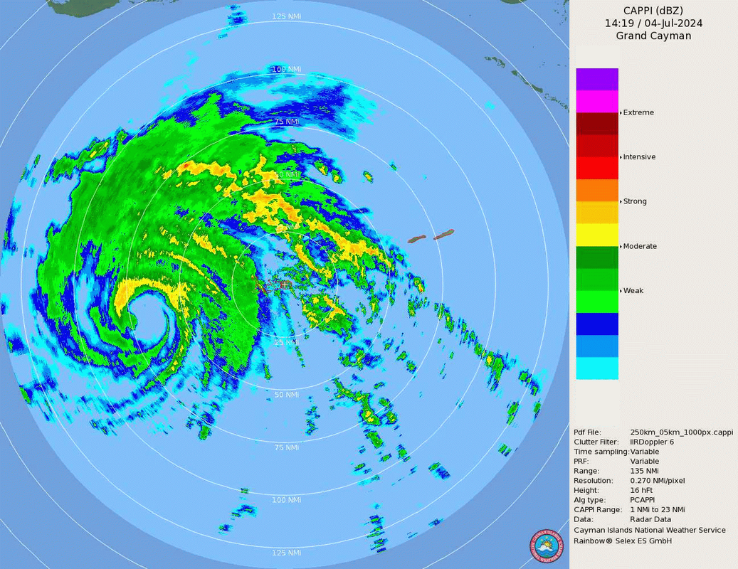
Last edited by Teban54 on Thu Jul 04, 2024 9:30 am, edited 1 time in total.
3 likes
TC naming lists: retirements and intensity
Most aggressive Advisory #1's in North Atlantic (cr. kevin for starting the list)
Most aggressive Advisory #1's in North Atlantic (cr. kevin for starting the list)

Re: ATL: BERYL - Hurricane - Discussion
ScottNAtlanta wrote:If it keeps going in the same direction it is going now, it will cross the Yucatan well north of 20 degrees
Maybe the ICON isn’t out to lunch with its northern solution after all.
I can potentially see a bit of intensification over the next 12-18 hours, since the eyewall is back to being closed and shear is dropping a bit.
2 likes
Irene '11 Sandy '12 Hermine '16 5/15/2018 Derecho Fay '20 Isaias '20 Elsa '21 Henri '21 Ida '21
I am only a meteorology enthusiast who knows a decent amount about tropical cyclones. Look to the professional mets, the NHC, or your local weather office for the best information.
I am only a meteorology enthusiast who knows a decent amount about tropical cyclones. Look to the professional mets, the NHC, or your local weather office for the best information.
-
tropicwatch

- Category 5
- Posts: 3427
- Age: 62
- Joined: Sat Jun 02, 2007 10:01 am
- Location: The Villages, Florida
- Contact:
Re: ATL: BERYL - Hurricane - Discussion
Thinking the strong upper-level high south of Beryl is helping to keep Beryl in check. By shutting down the outflow to the south.
0 likes
Tropicwatch
Agnes 72', Eloise 75, Elena 85', Kate 85', Charley 86', Florence 88', Beryl 94', Dean 95', Erin 95', Opal 95', Earl 98', Georges 98', Ivan 2004', Arlene 2005', Dennis 2005', Ida 2009' Debby 2012' Irma 2017' Michael 2018'
Agnes 72', Eloise 75, Elena 85', Kate 85', Charley 86', Florence 88', Beryl 94', Dean 95', Erin 95', Opal 95', Earl 98', Georges 98', Ivan 2004', Arlene 2005', Dennis 2005', Ida 2009' Debby 2012' Irma 2017' Michael 2018'
Re: ATL: BERYL - Hurricane - Discussion
jaguars_22 wrote:I think she has made her turn west as of latest satellite
At this point where Beryl is located it becomes increasingly difficult to track her true path the more she goes poleward. Radar and official HH reports are the best at this time.
1 likes
Re: ATL: BERYL - Hurricane - Discussion
Teban54 wrote:Even though the VDM an hour ago showed an open eyewall (as supported by radar around that time), it looks like Beryl is already working on repairing it:
https://i.postimg.cc/65Fp54QN/image.png
Actually, it showed a closed eyewall.
2 likes
Re: ATL: BERYL - Hurricane - Discussion
CIMSS just updated shear analysis
18 knots, down from 24
18 knots, down from 24
0 likes
-
TheAustinMan

- Category 5
- Posts: 1060
- Joined: Mon Jul 08, 2013 4:26 pm
- Location: Central TX / United States
Re: ATL: BERYL - Hurricane - Discussion
It's been quite remarkable how resilient Beryl has been in the face of less than ideal upper-level conditions. It's not even necessarily a case of conditions being more conducive than modeled either -- reconnaissance radar data has indicated that the strong mid- to upper-level wind shear has been present, with the core of the hurricane at times being subjected to 25-35 kt wind shear based on that radar data. However, Beryl's inner core has stood that test time and time again. Conditions become gradually more favorable as Beryl approaches the Yucatan Peninsula, and given the corridor of high tropical cyclone heat potential in its path and how intact it is, I would not be surprised if Beryl once again strengthens higher than the model guidance. In fact, that would be my expectation given that Beryl is better put together than modeled. Recent jogs slightly right of forecast may also implicate an increased severity of effects in Cozumel.
Source: TropicalTidbits for satellite, Cayman National Weather Service for radar

Source: TropicalTidbits for satellite, Cayman National Weather Service for radar
9 likes
Treat my opinions with a grain of salt. For official information see your local weather service.
“It's tough to make predictions, especially about the future.”
“It's tough to make predictions, especially about the future.”
Re: ATL: BERYL - Hurricane - Discussion
Lots of Cumulus forming on the northern Yucatan.
Beryl wont have any problem with dry air.
Beryl wont have any problem with dry air.
1 likes
Re: ATL: BERYL - Hurricane - Discussion
ColdMiser123 wrote:jconsor wrote:Thread on important short-term trends noted regarding Beryl, and how this influences her potential TX/MX impacts.
https://x.com/yconsor/status/1808853711629746332
Great writeup - lots of fantastic points made in this thread.
It is a great write-up....I wish I said all that....who is this person?....
0 likes
-
Pipelines182
- Tropical Storm

- Posts: 159
- Joined: Tue Jul 02, 2024 8:46 am
Re: ATL: BERYL - Hurricane - Discussion
20N is the latitude to watch. If Beryl crosses it before the Yucatán, the US comes into play in a major way.
0 likes
-
TallyTracker
- Category 2
- Posts: 787
- Joined: Thu Oct 11, 2018 2:46 pm
Re: ATL: BERYL - Hurricane - Discussion
Beryl’s been a major hurricane for over 4 days straight now. That’s not terribly common any time of year. Truely astonishing in June/July. Usually only 1-2 storms per year meet or exceed that number of major hurricane days.
8 likes
Fran '96, Georges '98, Gordon '00, Gabrielle '01, Charley '04, Frances '04, Jeanne '04, Barry '07, Fay '08, Debby '12, Matthew '16, Emily '17, Irma '17, Michael ‘18, Elsa ‘21, Fred ‘21, Mindy ‘21, Nicole ‘22, Idalia ‘23, Debby ‘24, Helene ‘24
-
NXStumpy_Robothing
- Category 1

- Posts: 335
- Age: 25
- Joined: Fri Jun 05, 2020 11:50 pm
- Location: North Georgia
Re: ATL: BERYL - Hurricane - Discussion
Pretty clear that Beryl will continue to outperform models, even those with smaller resolutions like the hurricane models. I would lean towards looking farther north and stronger than the current consensus track - we've been trending that way anyway, but still worth keeping in mind. Definitely not on-track to end up south of the Texas border as a weak cane (I'd expect stronger and further north at this point), barring some really terrible collapse between now and its entry into the Gulf across the mostly flat Yucatan Peninsula. I've mentioned some of the potential sources for error in the modeling in my previous message here: https://www.storm2k.org/phpbb2/viewtopic.php?f=59&t=124107&p=3071892#p3071892. Very impressive what Beryl has managed to do, as conditions aren't exactly favorable even with the nicest interpretation of the surrounding environment, but it's not as detrimental as forecast.
Just a sign that while the models are impressive and continue to get better year-after-year, they still have flaws/biases and in borderline situations - where even a slightly weaker system could have succumbed to the environmental factors working against it - they may not always be the most reliable. Worth keeping in mind for any future shifts as well.
Cantor's earlier thread about Beryl's performance is pretty much spot-on with what we've seen.
4 likes
Undergraduate Meteorology Student, Georgia Institute of Technology
Re: ATL: BERYL - Hurricane - Discussion
Pipelines182 wrote:20N is the latitude to watch. If Beryl crosses it before the Yucatán, the US comes into play in a major way.
IMO looking at the latest satellite imagery Beryl is now a bit above Grand Cayman’s latitude of 19.3. It is too dificult for me to tell by satellite imagery of her current movement.
4 likes
-
ColdMiser123

- Professional-Met
- Posts: 905
- Age: 29
- Joined: Mon Sep 26, 2016 3:26 pm
- Location: Northeast US
Re: ATL: BERYL - Hurricane - Discussion
3090 wrote:Pipelines182 wrote:20N is the latitude to watch. If Beryl crosses it before the Yucatán, the US comes into play in a major way.
IMO looking at the latest satellite imagery Beryl is now a bit above Grand Cayman’s latitude of 19.3. It is too dificult for me to tell by satellite imagery of her current movement.
Latest recon pass puts it at a tad north of 19.1N.
5 likes
B.S., M.S., Meteorology & Atmospheric Science
-
HurricaneBrain

- S2K Supporter

- Posts: 520
- Joined: Thu Jun 30, 2011 2:07 pm
Re: ATL: BERYL - Hurricane - Discussion
If Beryl continues toward the Yucatán with her general movement the past 5 hours, she will clip it. That WSW movement will need to happen today for models to verify.
6 likes
Who is online
Users browsing this forum: No registered users and 47 guests