Also Beryl:

Moderator: S2k Moderators


TomballEd wrote:hurricane2025 wrote:I like 57 but he’s all euro guy nothing wrong with that but can’t always follow euro
A professional met whose energy sector clients follow possible interruptions in the Gulf of Mexico follows only one model but keeps his clients. OK.
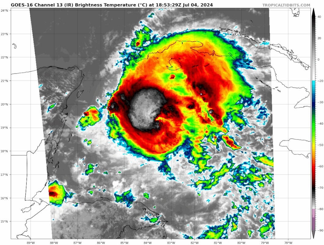
Pipelines182 wrote:Whelp, Beryl just wrapped cold deep convection all the way round it’s eye again. How is that even possible with 30 knots of windshear? I just don’t get it.


Pipelines182 wrote:Whelp, Beryl just wrapped cold deep convection all the way round it’s eye again. How is that even possible with 30 knots of windshear? I just don’t get it.

tropicwatch wrote:Of course, Beryl wants to perform when nobody is around. Next AF mission takes of around 3:45pm Central Time.
Category5Kaiju wrote:Pipelines182 wrote:Whelp, Beryl just wrapped cold deep convection all the way round it’s eye again. How is that even possible with 30 knots of windshear? I just don’t get it.
I'll give you a one word response: Michael.

Cpv17 wrote:MEANINGLESS_NUMBERS wrote:Cpv17 wrote:
I feel fairly confident this won’t be a MX landfall.
Well it's definitely going to hit Yucatán...
Final landfall.
Kazmit wrote:tropicwatch wrote:Of course, Beryl wants to perform when nobody is around. Next AF mission takes of around 3:45pm Central Time.
NHC will keep it at 95 kts until we get recon evidence of strengthening.
UTSARoadrunner4 wrote:Cpv17 wrote:MEANINGLESS_NUMBERS wrote:
Well it's definitely going to hit Yucatán...
Final landfall.
I didn’t think so before, but I’m starting to wrap my mind around an EXTREME NE Mexico or Boca Chica landfall. Furthest north I can reason with is North Padre and Corpus.
Now strength is something I’ll argue on. Unless it ends up in the Puucs, idk if it would degrade all the way down to a TS before getting into the Gulf.
MGC wrote:Convection is slowly starting to wrap around the east side of Beryl's circulation and with the eye reemerging shear looks to be relaxing. Landfall looks to be near Cozumel and should exit the trek across the Yucatan near Progresso as a TS. Depending on how badly the core is disrupted will determine how fast the hurricane will reintensify. Landfall north of Rio Grande is a good possibility......MGC
MGC wrote:Convection is slowly starting to wrap around the east side of Beryl's circulation and with the eye reemerging shear looks to be relaxing. Landfall looks to be near Cozumel and should exit the trek across the Yucatan near Progresso as a TS. Depending on how badly the core is disrupted will determine how fast the hurricane will reintensify. Landfall north of Rio Grande is a good possibility......MGC
MGC wrote:Convection is slowly starting to wrap around the east side of Beryl's circulation and with the eye reemerging shear looks to be relaxing. Landfall looks to be near Cozumel and should exit the trek across the Yucatan near Progresso as a TS. Depending on how badly the core is disrupted will determine how fast the hurricane will reintensify. Landfall north of Rio Grande is a good possibility......MGC
drexas wrote:Watching radar, Beryl also looks to have slowed down considerably recently. Anyone else seeing the same?
Edit: may just be perception from the storm reaching the edge of the radar's range
Users browsing this forum: No registered users and 67 guests