ATL: BERYL - Post-Tropical - Discussion
Moderator: S2k Moderators


Re: ATL: BERYL - Hurricane - Discussion
I think Beryl is gonna be pretty torn up when it exits the Yucatán later today. It will need a while to reorganize. However, with the models trending right, this could give Beryl more time over water than previously anticipated. RI doesn’t seem likely anytime soon, but if it does RI, it will be near landfall on the Texas coast.
2 likes
Igor 2010, Sandy 2012, Fay 2014, Gonzalo 2014, Joaquin 2015, Nicole 2016, Humberto 2019, Imelda 2025
I am only a tropical weather enthusiast. My predictions are not official and may or may not be backed by sound meteorological data. For official information, please refer to the NHC and NWS products.
I am only a tropical weather enthusiast. My predictions are not official and may or may not be backed by sound meteorological data. For official information, please refer to the NHC and NWS products.
-
jaguars_22
- Category 2

- Posts: 629
- Joined: Tue Jun 20, 2017 2:26 pm
- Location: Victoria TX
Re: ATL: BERYL - Hurricane - Discussion
I have a feeling this will be a Matagorda to Galveston storm! The recurve makes me in Victoria feel better as it will most likely begin moving northeast earlier
1 likes

Re: ATL: BERYL - Hurricane - Discussion
Beryl has made landfall (probably around 20.3N, 87.4W by interpolating between the last 2 fixes) and is now estimated to be a low-end cat 2.
...CENTER OF BERYL MOVING INLAND OVER THE YUCATAN PENINSULA...
...DANGEROUS HURRICANE-FORCE WINDS, STORM SURGE, AND DAMAGING WAVES
EXPECTED IN THE LANDFALL AREA THIS MORNING...
SUMMARY OF 700 AM CDT...1200 UTC...INFORMATION
----------------------------------------------
LOCATION...20.4N 87.6W
ABOUT 15 MI...25 KM NNW OF TULUM MEXICO
ABOUT 730 MI...1175 KM ESE OF BROWNSVILLE TEXAS
MAXIMUM SUSTAINED WINDS...100 MPH...160 KM/H
PRESENT MOVEMENT...WNW OR 285 DEGREES AT 15 MPH...24 KM/H
MINIMUM CENTRAL PRESSURE...980 MB...28.94 INCHES
0 likes
Re: ATL: BERYL - Hurricane - Discussion
GCANE wrote:That ULL in the GoM looks formidable.
Strong PVS wall for Beryl to hit as she enters into the GoM.
ULL will move west and anchor inshore on east side of Mexico providing a strong directional shear (south to north) for Beryl to ride through.
Doubt Beryl will get much above a TS in the GoM.
May get some slight strengthening before landfall due to a high CAPE pool that typically sits offshore of the TX coast.
Wouldn't that ULL parked over eastern Mexico cause Beryl to move more north in addition to more west/southerly shear?
1 likes
-
HurricaneBrain

- S2K Supporter

- Posts: 520
- Joined: Thu Jun 30, 2011 2:07 pm
Re: ATL: BERYL - Hurricane - Discussion
There’s a situation where we could see a strengthening hurricane in the Gulf tomorrow taking aim at populated Texas beaches that aren’t expecting it. With 4th of Julyers heading home Sunday, it would be a cluster if evacuations were ordered. I know the majority of people in Galveston would be unprepared, especially with local mets continuing to assure locals of a Brownsville landfall (not saying this doesn’t end up happening but it is trending away from that solution).
Last edited by HurricaneBrain on Fri Jul 05, 2024 7:19 am, edited 1 time in total.
4 likes
-
cycloneye

- Admin

- Posts: 149721
- Age: 69
- Joined: Thu Oct 10, 2002 10:54 am
- Location: San Juan, Puerto Rico
Re: ATL: BERYL - Hurricane - Discussion
1 likes
Visit the Caribbean-Central America Weather Thread where you can find at first post web cams,radars
and observations from Caribbean basin members Click Here
and observations from Caribbean basin members Click Here
Re: ATL: BERYL - Hurricane - Discussion
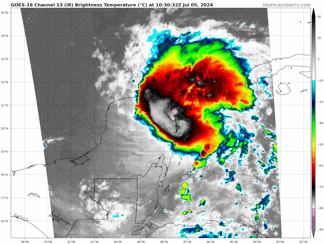
Teban54 wrote:Beryl's eye is seemingly getting a bit better defined on IR at the Yucatan landfall:
https://i.postimg.cc/0yqPX0wt/goes16-ir-meso1-3.gif
Looks like a flat out mess to me.
0 likes
Re: ATL: BERYL - Hurricane - Discussion
HurricaneBrain wrote:There’s a situation where we could see a strengthening hurricane in the Gulf tomorrow taking aim at populated Texas beaches that aren’t expecting it. With 4th of Julyers heading home Sunday, it would be a cluster if evacuations were ordered. I know the majority of people in Galveston would be unprepared, especially with local mets continuing to assure locals of a Brownsville landfall (not saying this doesn’t end up happening but it is trending away from that solution).
A direct Galveston strike is highly unlikely. Brownsville to Corpus seems like the favored location as of now. That isn’t to say Galveston won’t see any impacts, as surge could still be an issue.
1 likes
-
HurricaneBrain
- S2K Supporter
- Posts: 520
- Joined: Thu Jun 30, 2011 2:07 pm
Re: ATL: BERYL - Hurricane - Discussion
Galveston is well within the cone, with the NHC explicitly stating that more northward shifts could come. I mentioned Galveston because residents and visitors are being informed it is not really a possibility (when in fact there is a small possibility) that a hurricane could be taking aim for them in the coming days, hence being unprepared if this situation comes into fruition.
wx98 wrote:HurricaneBrain wrote:There’s a situation where we could see a strengthening hurricane in the Gulf tomorrow taking aim at populated Texas beaches that aren’t expecting it. With 4th of Julyers heading home Sunday, it would be a cluster if evacuations were ordered. I know the majority of people in Galveston would be unprepared, especially with local mets continuing to assure locals of a Brownsville landfall (not saying this doesn’t end up happening but it is trending away from that solution).
A direct Galveston strike is highly unlikely. Brownsville to Corpus seems like the favored location as of now. That isn’t to say Galveston won’t see any impacts, as surge could still be an issue.
5 likes
-
Tireman4

- S2K Supporter
- Posts: 5904
- Age: 60
- Joined: Fri Jun 30, 2006 1:08 pm
- Location: Humble, Texas
- Contact:
Re: ATL: BERYL - Hurricane - Discussion
From the HGX NWS
.TROPICAL...
Issued at 400 AM CDT Fri Jul 5 2024
As of ~4am CDT, Beryl is now a category 2 hurricane and is just off
of the coast of the northeastern portion of the Yucatan Peninsula
where it`ll make landfall later this morning. It is currently moving
west-northwestward and will make its way into the southwestern Gulf
by Friday evening. The 06Z suite of models trended a bit more
northward compared to the 00Z models with most consensus pointing
toward a South TX landfall Sunday night/Monday morning. There are
still a few factors at play that will determine Beryl`s final
landfall including where Beryl emerges from the Yucatan Peninsula
later today (what latitude is it at when it enters the Gulf), how
quickly the ridge currently over the SE CONUS moves eastward (and
subsequently how deep is the upper level trough that will push the
ridge eastward), and how much it can intensify over the Gulf
(stronger tropical cyclones tend to drift more poleward).
While uncertainty remains for the end of the forecast track/final
landfall, there is at least some certainty that rainfall chances
will increase early next week along with an increasing risk of rip
currents.
Please continue to monitor the latest forecasts and updates from the
National Hurricane Center at www.hurricanes.gov as any significant
changes in the track and/or intensity forecast could lead to
significant changes in our area forecast.
Batiste
1 likes
Re: ATL: BERYL - Hurricane - Discussion
HurricaneBrain wrote:Galveston is well within the cone, with the NHC explicitly stating that more northward shifts could come. I mentioned Galveston because residents and visitors are being informed it is not really a possibility (when in fact there is a small possibility) that a hurricane could be taking aim for them in the coming days, hence being unprepared if this situation comes into fruition.wx98 wrote:HurricaneBrain wrote:There’s a situation where we could see a strengthening hurricane in the Gulf tomorrow taking aim at populated Texas beaches that aren’t expecting it. With 4th of Julyers heading home Sunday, it would be a cluster if evacuations were ordered. I know the majority of people in Galveston would be unprepared, especially with local mets continuing to assure locals of a Brownsville landfall (not saying this doesn’t end up happening but it is trending away from that solution).
A direct Galveston strike is highly unlikely. Brownsville to Corpus seems like the favored location as of now. That isn’t to say Galveston won’t see any impacts, as surge could still be an issue.
As I said, a direct strike is unlikely, but they will likely feel some effects in the form of surge and outer bands.
1 likes
-
Tireman4
- S2K Supporter
- Posts: 5904
- Age: 60
- Joined: Fri Jun 30, 2006 1:08 pm
- Location: Humble, Texas
- Contact:
Re: ATL: BERYL - Hurricane - Discussion
wx98 wrote:HurricaneBrain wrote:Galveston is well within the cone, with the NHC explicitly stating that more northward shifts could come. I mentioned Galveston because residents and visitors are being informed it is not really a possibility (when in fact there is a small possibility) that a hurricane could be taking aim for them in the coming days, hence being unprepared if this situation comes into fruition.wx98 wrote:A direct Galveston strike is highly unlikely. Brownsville to Corpus seems like the favored location as of now. That isn’t to say Galveston won’t see any impacts, as surge could still be an issue.
As I said, a direct strike is unlikely, but they will likely feel some effects in the form of surge and outer bands.
With all due respect, please do not say that. You absolutely could be right or you could be wrong. ALL residents along the Texas coast should be prepared for anything. Stay tuned to the NHC and your local NWS. With landfalling tropical systems, everything can be in play. Ike, Allison and Harvey come to mind. Thank you.
5 likes

Re: ATL: BERYL - Hurricane - Discussion
hipshot wrote:GCANE wrote:That ULL in the GoM looks formidable.
Strong PVS wall for Beryl to hit as she enters into the GoM.
ULL will move west and anchor inshore on east side of Mexico providing a strong directional shear (south to north) for Beryl to ride through.
Doubt Beryl will get much above a TS in the GoM.
May get some slight strengthening before landfall due to a high CAPE pool that typically sits offshore of the TX coast.
Wouldn't that ULL parked over eastern Mexico cause Beryl to move more north in addition to more west/southerly shear?
Yes
0 likes
Re: ATL: BERYL - Hurricane - Discussion
I’m not going to say Galveston is completely in the clear because there is a handful of members from the GEFS and EPS that show it is a possibility. ICON is also showing a Freeport landfall and it has been pretty good with Beryl so far. I do agree that it is not likely but I just can’t rule it out yet.
0 likes
Re: ATL: BERYL - Hurricane - Discussion
One thing going for Beryl is a very nice poleward outflow channel
0 likes

Re: ATL: BERYL - Hurricane - Discussion
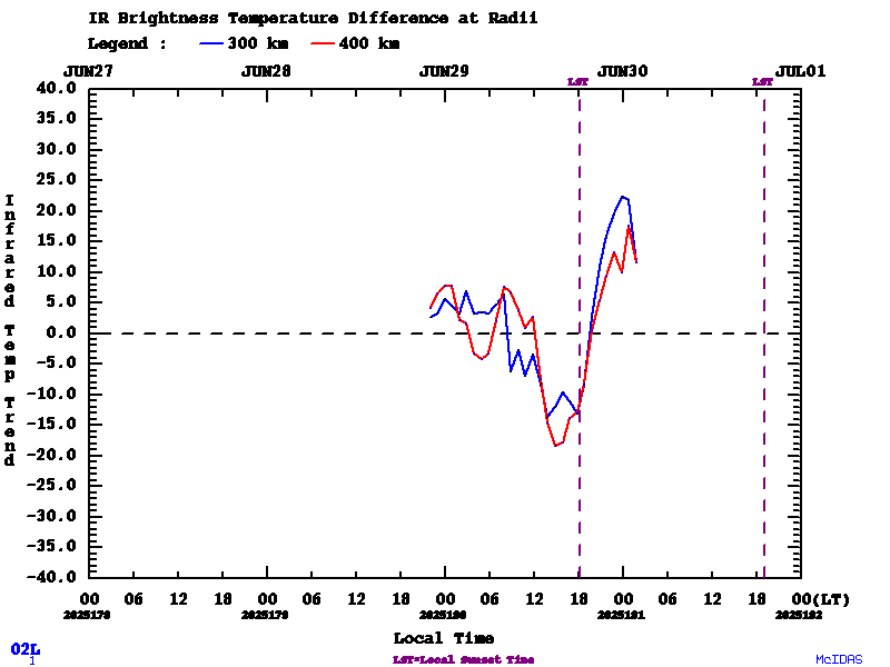
Later this afternoon, Beryl should hit a diurnal peak. We'll see if this happens.
https://tropic.ssec.wisc.edu/real-time/ ... 02L-2B.GIF
https://tropic.ssec.wisc.edu/real-time/ ... 02L-2B.GIF
1 likes

-
jaguars_22
- Category 2
- Posts: 629
- Joined: Tue Jun 20, 2017 2:26 pm
- Location: Victoria TX
Re: ATL: BERYL - Hurricane - Discussion
Whoa, it looks like Beryl took a big jog north if I understand where the eye might be!
0 likes
Who is online
Users browsing this forum: No registered users and 66 guests