

Prognosticated rainfall rates through 72 hours
ICON
https://www.tropicaltidbits.com/analysi ... 0612&fh=72
GFS
https://www.tropicaltidbits.com/analysi ... 0612&fh=72
FV-3 Hi-res (only out to 60 hours)
https://www.tropicaltidbits.com/analysi ... 0612&fh=60
NAM 12km
https://www.tropicaltidbits.com/analysi ... 0612&fh=72
Looks like a general 4-6" for Houston per these models. It does flood there, but this doesn't look too extreme. NAM has more rain but it's a bit farther west
ATL: BERYL - Models
Moderator: S2k Moderators
Re: ATL: BERYL - Models
1 likes
Re: ATL: BERYL - Models
I don’t know what to think about the HWRF. It also shows a big pulse at landfall. But it goes in south and comes up west of everything else I looked at so far. Closest to NAM but instead of going north it continues NW toward San Antonio and New Braunfels. So it’s feeling the ridge to be a little farther west I suppose.
https://www.tropicaltidbits.com/analysi ... 70612&fh=6
https://www.tropicaltidbits.com/analysi ... 70612&fh=6
2 likes
Re: ATL: BERYL - Models
HMON also shows best organization right at landfall but less than HWRF. It comes up a little east of HWRF and a little west of most of the earlier models.
0 likes


Re: ATL: BERYL - Models
HWRF is showing a closed moisture pocket forming between 03-09z Sunday. If is verifies, that’s when we should start seeing some more pronounced recovery.
0 likes
Irene '11 Sandy '12 Hermine '16 5/15/2018 Derecho Fay '20 Isaias '20 Elsa '21 Henri '21 Ida '21
I am only a meteorology enthusiast who knows a decent amount about tropical cyclones. Look to the professional mets, the NHC, or your local weather office for the best information.
I am only a meteorology enthusiast who knows a decent amount about tropical cyclones. Look to the professional mets, the NHC, or your local weather office for the best information.
-
Craters
- Category 1

- Posts: 428
- Joined: Sat Aug 24, 2013 2:34 pm
- Location: Alvin, TX (south of Houston)
Re: ATL: BERYL - Models
aspen wrote:HWRF is showing a closed moisture pocket forming between 03-09z Sunday. If is verifies, that’s when we should start seeing some more pronounced recovery.
That's when the European drops 8 mb in one frame, too...
0 likes
Nothing that I post here should ever be treated as a forecast or anything resembling one. Please check with your local NWS office or the NHC for forecasts, watches, and warnings.
-
tolakram
- Admin

- Posts: 20186
- Age: 62
- Joined: Sun Aug 27, 2006 8:23 pm
- Location: Florence, KY (name is Mark)
Re: ATL: BERYL - Models
979MB on a global which has a habit of underestimating strength. This is why I'm harping on the messaging. I don't know if it will be a cat 4 or cat 1, and I don't think the pro's do either.

7 likes
M a r k
- - - - -
Join us in chat: Storm2K Chatroom Invite. Android and IOS apps also available.
The posts in this forum are NOT official forecasts and should not be used as such. Posts are NOT endorsed by any professional institution or STORM2K.org. For official information and forecasts, please refer to NHC and NWS products.
Re: ATL: BERYL - Models
12Z Euro landfall is just east of Matagorda Bay. Landfall is close to where Nicholas made landfall in 2021.
0 likes

Re: ATL: BERYL - Models
IcyTundra wrote:18Z ICON landfall near Freeport
https://i.ibb.co/7VZntzv/icon-mslp-pcpn-watl-fh3-45.gif
iCON still showing this track. I am beginning to wonder if it is just a scratch in the CD..
2 likes
-
jaguars_22
- Category 2

- Posts: 629
- Joined: Tue Jun 20, 2017 2:26 pm
- Location: Victoria TX
-
jaguars_22
- Category 2
- Posts: 629
- Joined: Tue Jun 20, 2017 2:26 pm
- Location: Victoria TX
Re: ATL: BERYL - Models
How good are the hurricane models that show Corpus Christi to rockport still?? Should we throw those out?
Hwrf hafs
Hwrf hafs
0 likes
Re: ATL: BERYL - Models
jaguars_22 wrote:Normally the icon caves… satellite is improving
When it’s an outlier sometimes as most of them do. But not always. Icon/EC is a decent alliance. It sees things ahead of other models sometimes. Genesis and position. Pretty much everything else was south of Texas then the border. Then south padre. Maybe they’ll be right. Icon didn’t waver for better or worse. We gonna see.
3 likes
Re: ATL: BERYL - Models
Steve wrote:jaguars_22 wrote:Normally the icon caves… satellite is improving
When it’s an outlier sometimes as most of them do. But not always. Icon/EC is a decent alliance. It sees things ahead of other models sometimes. Genesis and position. Pretty much everything else was south of Texas then the border. Then south padre. Maybe they’ll be right. Icon didn’t waver for better or worse. We gonna see.
12Z Euro isn't that far off from the ICON. 12Z Euro Ensemble also has some members into Freeport so it is a possibilty still.
0 likes
Re: ATL: BERYL - Models
18Z NAM up Matagorda and angles over to N Houston....depending on what happens in the next 24hrs it could still be fairly potent then...
Last edited by ROCK on Sat Jul 06, 2024 4:50 pm, edited 1 time in total.
0 likes
Re: ATL: BERYL - Models
IcyTundra wrote:Steve wrote:jaguars_22 wrote:Normally the icon caves… satellite is improving
When it’s an outlier sometimes as most of them do. But not always. Icon/EC is a decent alliance. It sees things ahead of other models sometimes. Genesis and position. Pretty much everything else was south of Texas then the border. Then south padre. Maybe they’ll be right. Icon didn’t waver for better or worse. We gonna see.
12Z Euro isn't that far off from the ICON. 12Z Euro Ensemble also has some members into Freeport so it is a possibility still.
I havent seen the Euro ensembles today..can you post of point me in that direction. My prior link is toast.
0 likes
Re: ATL: BERYL - Models
GFS is running.
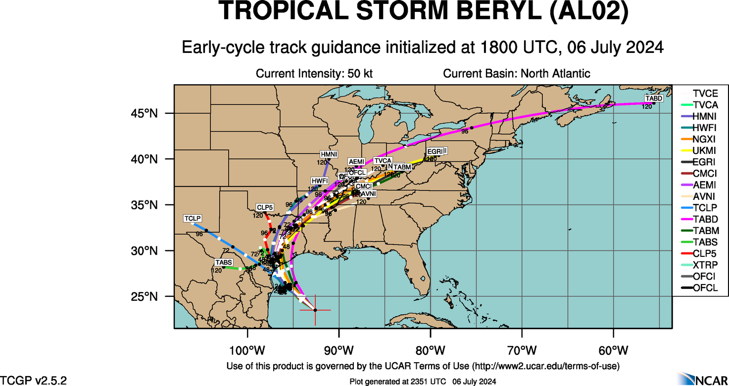
Here’s the early cycle 18z. Most mid coast
https://hurricanes.ral.ucar.edu/realtim ... _early.png
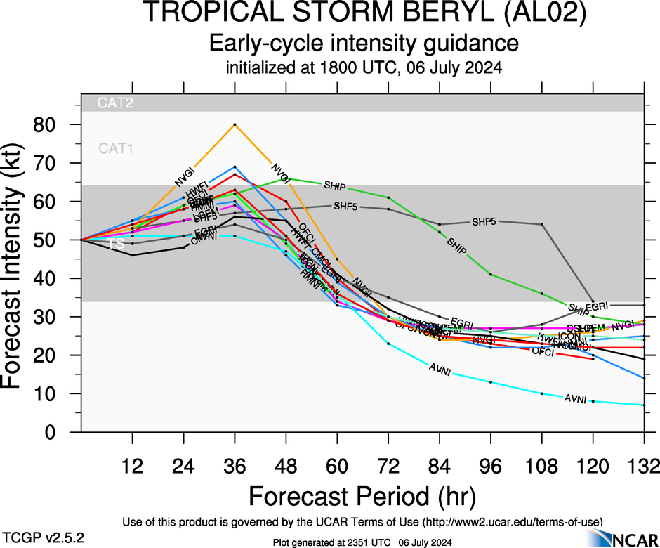
Early cycle intensity for 18z. Note all models peak at 36 hours/landfall +/- Might be slightly underdone as strengthening Cat 1 is my best guess.
https://hurricanes.ral.ucar.edu/realtim ... _early.png
Here’s the early cycle 18z. Most mid coast
https://hurricanes.ral.ucar.edu/realtim ... _early.png
Early cycle intensity for 18z. Note all models peak at 36 hours/landfall +/- Might be slightly underdone as strengthening Cat 1 is my best guess.
https://hurricanes.ral.ucar.edu/realtim ... _early.png
1 likes
Re: ATL: BERYL - Models
ROCK wrote:IcyTundra wrote:Steve wrote:
When it’s an outlier sometimes as most of them do. But not always. Icon/EC is a decent alliance. It sees things ahead of other models sometimes. Genesis and position. Pretty much everything else was south of Texas then the border. Then south padre. Maybe they’ll be right. Icon didn’t waver for better or worse. We gonna see.
12Z Euro isn't that far off from the ICON. 12Z Euro Ensemble also has some members into Freeport so it is a possibility still.
I havent seen the Euro ensembles today..can you post of point me in that direction. My prior link is toast.
My bad those were 06.
Last edited by Steve on Sat Jul 06, 2024 4:52 pm, edited 1 time in total.
1 likes


Re: ATL: BERYL - Models
18Z GFS shifted a little further east now into the middle of Matagorda Bay. Beryl strengthens 9 MB in between hour 36 and hour 42 of the run. Could be more than that because it is showing 984 MB inland and probably weakened a little bit.
0 likes
Who is online
Users browsing this forum: No registered users and 57 guests