- Verbatim, the July Euro is forecasting ONI of ~-0.1C in ASO, which is a bit warmer than the June run.
- The Euro runs over the last 15++ years have averaged too warm. My educated guess is that July has averaged 0.2 too warm for ASO.
- Thus the implied bias corrected (bc) July Euro ASO ONI prog is for -0.3.
- The latest ONI-RONI is +0.61 and has only slowly been falling from earlier record peak of +0.66. So, it’s realistic to assume an ASO ONI-RONI still up at ~+0.5. This means the bc July Euro prog for ASO RONI is ~-0.8.
- Regarding implications for H season, I posted in late May that on avg the worst seasons for US H landfalls, especially NE Gulf to Carolinas, have been when ASO RONI was weak La Niña as opposed to either mod/strong Niña or cold neutral. This is also the case for the area from the Bahamas to Lesser Antilles. This was backed by maps posted by another member.
-The bc July Euro prog for ASO RONI of ~-0.8 would be ~the worst ASO RONI if one doesn’t want a bad season. That doesn’t mean it will be bad though as not all with a weak Niña have been. These are just averages. Two months ago, when I first studied this, it was looking like ASO RONI would be below -1.0, which would have had not as bad implications for the SE US to E Caribbean.
2024 Indicators: SST's, MSLP, Shear, SAL, Steering, Instability (Day 16+ Climate Models)
Moderator: S2k Moderators
Forum rules

The posts in this forum are NOT official forecasts and should not be used as such. They are just the opinion of the poster and may or may not be backed by sound meteorological data. They are NOT endorsed by any professional institution or STORM2K. For official information, please refer to products from the National Hurricane Center and National Weather Service.
Re: 2024 Indicators: SST's, MSLP, Shear, SAL, Steering, Instability (Day 16+ Climate Models)
Last edited by LarryWx on Fri Jul 05, 2024 4:37 pm, edited 1 time in total.
1 likes
Personal Forecast Disclaimer:
The posts in this forum are NOT official forecasts and should not be used as such. They are just the opinion of the poster and may or may not be backed by sound meteorological data. They are NOT endorsed by any professional institution or storm2k.org. For official information, please refer to the NHC and NWS products.
The posts in this forum are NOT official forecasts and should not be used as such. They are just the opinion of the poster and may or may not be backed by sound meteorological data. They are NOT endorsed by any professional institution or storm2k.org. For official information, please refer to the NHC and NWS products.
-
SFLcane

- S2K Supporter

- Posts: 10281
- Age: 48
- Joined: Sat Jun 05, 2010 1:44 pm
- Location: Lake Worth Florida
Re: 2024 Indicators: SST's, MSLP, Shear, SAL, Steering, Instability (Day 16+ Climate Models)
LarryWx wrote:- Verbatim, the July Euro is forecasting ONI of ~-0.1C in ASO, which is a bit warmer than the June run.
- The Euro runs over the last 15++ years have averaged too warm. My educated guess is that July has averaged 0.2 too warm for ASO.
- Thus the implied bias corrected (bc) July Euro ASO ONI prog is for -0.3.
- The latest ONI-RONI is +0.61 and has only slowly been falling from earlier record peak of +0.66. So, it’s realistic to assume an ASO ONI-RONI still up at ~+0.5. This means the bc July Euro prog for ASO RONI is ~-0.8.
- Regarding implications for H season, I posted in late May that on avg the worst seasons for US H landfalls, especially NE Gulf to Carolinas, have been when ASO RONI was weak La Niña as opposed to either mod/strong Niña or cold neutral. This is also the case for the area from the Bahamas to Lesser Antilles. This was backed by maps posted by another member. The bc July Euro prog for ASO RONI of ~-0.8 would be ~the worst ASO RONI if one doesn’t want a bad season. That doesn’t mean it will be bad though as not all with a weak Niña have been. These are just averages. Two months ago, when I first studied this, it was looking like ASO RONI would be below -1.0, which would have had not as bad implications for the SE US.
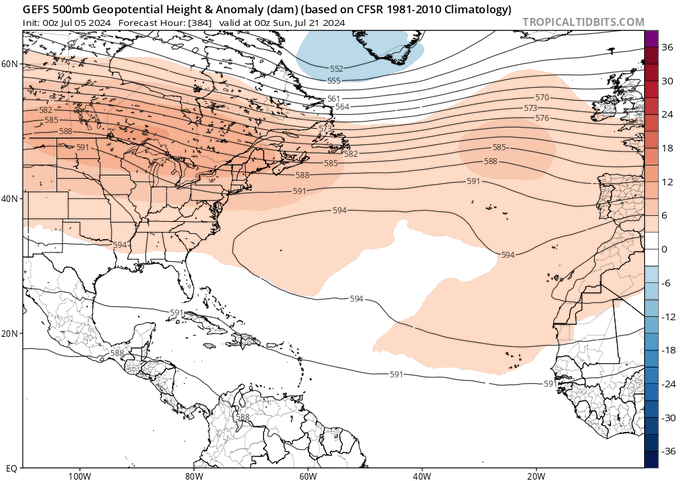
The new Euro is going with Neutral enso conditions for most of the season which in my opinion is not a good thing considering how nasty it can get for the Southeast. Honestly the ecmwf for July is not much different from it’s June forecast it’s just not accounting for massive ace from beryl which not matter how you slice it easily puts us into hyper active territory. Looking at long range guidance which off course should be taken with huge grain of salt continues with much stronger ridge into mid July.
4 likes

Re: 2024 Indicators: SST's, MSLP, Shear, SAL, Steering, Instability (Day 16+ Climate Models)
Hurricane2022 wrote:WaveBreaking wrote:Category5Kaiju wrote:
2. Extremely warm sst anomalies. Not only that though, but if you look at a map showing 2005 and 2024's sst anomaly distribution at around the same time near late June, you'll notice an interesting similarity.
Yeah 2024 and 2005 do look eerily similar currently, with the main difference being 2005 having a slight +PDO and full blown Atlantic Niña while 2024 has a -PDO and a less pronounced Atlantic Niña. I wonder if these differences will influence steering/favorability this year compared to 2005.
https://imgur.com/rbKSqaI.jpg
https://imgur.com/BQVfIPU.jpg
I wonder if that warm blob between Newfoundland and the Azores might affect activity in the tropics a bit in the coming months.
My thought exactly. There was a huge warm blob further west in 2022 that increased subsidence and wave-breaking in the MDR, leading to a rare dead August and a less active than anticipated season. Perhaps 2024’s warm blob could be enough to put a cap on pre-September activity or cause the season to fall slightly below forecasts (like 16-19 NS and 120-160 ACE instead of 20-25 NS and 160-200+ ACE). Or maybe it’ll be totally inconsequential and nothing like the 2022 blob due to its slightly different location.
0 likes
Irene '11 Sandy '12 Hermine '16 5/15/2018 Derecho Fay '20 Isaias '20 Elsa '21 Henri '21 Ida '21
I am only a meteorology enthusiast who knows a decent amount about tropical cyclones. Look to the professional mets, the NHC, or your local weather office for the best information.
I am only a meteorology enthusiast who knows a decent amount about tropical cyclones. Look to the professional mets, the NHC, or your local weather office for the best information.
-
Category5Kaiju

- Category 5

- Posts: 4330
- Joined: Thu Dec 24, 2020 12:45 pm
- Location: Seattle and Phoenix
Re: 2024 Indicators: SST's, MSLP, Shear, SAL, Steering, Instability (Day 16+ Climate Models)
aspen wrote:Hurricane2022 wrote:WaveBreaking wrote:
Yeah 2024 and 2005 do look eerily similar currently, with the main difference being 2005 having a slight +PDO and full blown Atlantic Niña while 2024 has a -PDO and a less pronounced Atlantic Niña. I wonder if these differences will influence steering/favorability this year compared to 2005.
https://imgur.com/rbKSqaI.jpg
https://imgur.com/BQVfIPU.jpg
I wonder if that warm blob between Newfoundland and the Azores might affect activity in the tropics a bit in the coming months.
My thought exactly. There was a huge warm blob further west in 2022 that increased subsidence and wave-breaking in the MDR, leading to a rare dead August and a less active than anticipated season. Perhaps 2024’s warm blob could be enough to put a cap on pre-September activity or cause the season to fall slightly below forecasts (like 16-19 NS and 120-160 ACE instead of 20-25 NS and 160-200+ ACE). Or maybe it’ll be totally inconsequential and nothing like the 2022 blob due to its slightly different location.
The main reasons why I believe that warm blob won't really impact the season is because it seems to be associated with a ridge of high pressure (if I'm not mistaken, the NE US is undergoing some pretty decent heat right now). And you also have to remember 2022 had more factors going against it than for it (third year La Nina, not-so-warm deep tropics, etc.) than 2024 does not have.
The setup this year seems to be rather different and much more favorable, and especially with Beryl having occurred, I have a strong suspicion that we're going to see more powerful Cape Verde hurricanes down the road, eventually yielding a high ACE score. If we get a Category 5 Caribbean-cruising storm in EARLY JULY, then what's to say that this season is going to underperform?
4 likes
Unless explicitly stated, all info in my posts is based on my own opinions and observations. Tropical storms and hurricanes can be extremely dangerous. Refer to an accredited weather research agency or meteorologist if you need to make serious decisions regarding an approaching storm.
-
WeatherBoy2000
- Category 1

- Posts: 460
- Joined: Mon Apr 10, 2023 9:29 am
Re: 2024 Indicators: SST's, MSLP, Shear, SAL, Steering, Instability (Day 16+ Climate Models)
aspen wrote:Hurricane2022 wrote:WaveBreaking wrote:
Yeah 2024 and 2005 do look eerily similar currently, with the main difference being 2005 having a slight +PDO and full blown Atlantic Niña while 2024 has a -PDO and a less pronounced Atlantic Niña. I wonder if these differences will influence steering/favorability this year compared to 2005.
https://imgur.com/rbKSqaI.jpg
https://imgur.com/BQVfIPU.jpg
I wonder if that warm blob between Newfoundland and the Azores might affect activity in the tropics a bit in the coming months.
My thought exactly. There was a huge warm blob further west in 2022 that increased subsidence and wave-breaking in the MDR, leading to a rare dead August and a less active than anticipated season. Perhaps 2024’s warm blob could be enough to put a cap on pre-September activity or cause the season to fall slightly below forecasts (like 16-19 NS and 120-160 ACE instead of 20-25 NS and 160-200+ ACE). Or maybe it’ll be totally inconsequential and nothing like the 2022 blob due to its slightly different location.
2024 will have a 35-40 ace head start when all is said in done with Beryl. You'd have to have a weaker peak season than 2022 to get this year below 125-130 ace. Tbh forecasts would have to bust pretty bad for 2024 to not at least meet the minimum for hyperactivity at this point.
3 likes
-
captainbarbossa19

- Professional-Met

- Posts: 1094
- Age: 27
- Joined: Wed Aug 21, 2019 11:09 pm
- Location: Beaumont, TX
Re: 2024 Indicators: SST's, MSLP, Shear, SAL, Steering, Instability (Day 16+ Climate Models)
WeatherBoy2000 wrote:aspen wrote:Hurricane2022 wrote:I wonder if that warm blob between Newfoundland and the Azores might affect activity in the tropics a bit in the coming months.
My thought exactly. There was a huge warm blob further west in 2022 that increased subsidence and wave-breaking in the MDR, leading to a rare dead August and a less active than anticipated season. Perhaps 2024’s warm blob could be enough to put a cap on pre-September activity or cause the season to fall slightly below forecasts (like 16-19 NS and 120-160 ACE instead of 20-25 NS and 160-200+ ACE). Or maybe it’ll be totally inconsequential and nothing like the 2022 blob due to its slightly different location.
2024 will have a 35-40 ace head start when all is said in done with Beryl. You'd have to have a weaker peak season than 2022 to get this year below 125-130 ace. Tbh forecasts would have to bust pretty bad for 2024 to not at least meet the minimum for hyperactivity at this point.
If we see nothing on the horizon after Beryl though on models, I guarantee we will have season cancel posts coming! Even 2005 had midseason doldrums.
6 likes
-
weeniepatrol

- Category 5
- Posts: 1341
- Joined: Sat Aug 22, 2020 5:30 pm
- Location: WA State
Re: 2024 Indicators: SST's, MSLP, Shear, SAL, Steering, Instability (Day 16+ Climate Models)
captainbarbossa19 wrote:WeatherBoy2000 wrote:aspen wrote:My thought exactly. There was a huge warm blob further west in 2022 that increased subsidence and wave-breaking in the MDR, leading to a rare dead August and a less active than anticipated season. Perhaps 2024’s warm blob could be enough to put a cap on pre-September activity or cause the season to fall slightly below forecasts (like 16-19 NS and 120-160 ACE instead of 20-25 NS and 160-200+ ACE). Or maybe it’ll be totally inconsequential and nothing like the 2022 blob due to its slightly different location.
2024 will have a 35-40 ace head start when all is said in done with Beryl. You'd have to have a weaker peak season than 2022 to get this year below 125-130 ace. Tbh forecasts would have to bust pretty bad for 2024 to not at least meet the minimum for hyperactivity at this point.
If we see nothing on the horizon after Beryl though on models, I guarantee we will have season cancel posts coming! Even 2005 had midseason doldrums.
I remember going thru the archives and seeing a post from someone in NOLA asking when activity will pick back up... like five days before Katrina hit em.
9 likes
-
jlauderdal
- S2K Supporter
- Posts: 7240
- Joined: Wed May 19, 2004 5:46 am
- Location: NE Fort Lauderdale
- Contact:
Re: 2024 Indicators: SST's, MSLP, Shear, SAL, Steering, Instability (Day 16+ Climate Models)
captainbarbossa19 wrote:WeatherBoy2000 wrote:aspen wrote:My thought exactly. There was a huge warm blob further west in 2022 that increased subsidence and wave-breaking in the MDR, leading to a rare dead August and a less active than anticipated season. Perhaps 2024’s warm blob could be enough to put a cap on pre-September activity or cause the season to fall slightly below forecasts (like 16-19 NS and 120-160 ACE instead of 20-25 NS and 160-200+ ACE). Or maybe it’ll be totally inconsequential and nothing like the 2022 blob due to its slightly different location.
2024 will have a 35-40 ace head start when all is said in done with Beryl. You'd have to have a weaker peak season than 2022 to get this year below 125-130 ace. Tbh forecasts would have to bust pretty bad for 2024 to not at least meet the minimum for hyperactivity at this point.
If we see nothing on the horizon after Beryl though on models, I guarantee we will have season cancel posts coming! Even 2005 had midseason doldrums.
Mid to late July is prime time for season cancel posts.
4 likes
Re: 2024 Indicators: SST's, MSLP, Shear, SAL, Steering, Instability (Day 16+ Climate Models)
jlauderdal wrote:captainbarbossa19 wrote:WeatherBoy2000 wrote:
2024 will have a 35-40 ace head start when all is said in done with Beryl. You'd have to have a weaker peak season than 2022 to get this year below 125-130 ace. Tbh forecasts would have to bust pretty bad for 2024 to not at least meet the minimum for hyperactivity at this point.
If we see nothing on the horizon after Beryl though on models, I guarantee we will have season cancel posts coming! Even 2005 had midseason doldrums.
Mid to late July is prime time for season cancel posts.
I’m not trying to season cancel lol. Just pointing out that the subtropical warm blob could be an unforeseen slight limiting factor this season, somewhat counteracting the clearly hyper-favorable deep tropics and base state. It is a departure from the classic +AMO configuration the basin has had for the entire year up until now. We’ll just have to see how the SSTA pattern evolves as we get closer to August.
0 likes
Irene '11 Sandy '12 Hermine '16 5/15/2018 Derecho Fay '20 Isaias '20 Elsa '21 Henri '21 Ida '21
I am only a meteorology enthusiast who knows a decent amount about tropical cyclones. Look to the professional mets, the NHC, or your local weather office for the best information.
I am only a meteorology enthusiast who knows a decent amount about tropical cyclones. Look to the professional mets, the NHC, or your local weather office for the best information.
-
Category5Kaiju
- Category 5
- Posts: 4330
- Joined: Thu Dec 24, 2020 12:45 pm
- Location: Seattle and Phoenix
Re: 2024 Indicators: SST's, MSLP, Shear, SAL, Steering, Instability (Day 16+ Climate Models)
As we enter the lull, just a cautious reminder that sometimes, these 45-day models can be...well, kind of off.

5 likes
Unless explicitly stated, all info in my posts is based on my own opinions and observations. Tropical storms and hurricanes can be extremely dangerous. Refer to an accredited weather research agency or meteorologist if you need to make serious decisions regarding an approaching storm.
-
tolakram
- Admin

- Posts: 20178
- Age: 62
- Joined: Sun Aug 27, 2006 8:23 pm
- Location: Florence, KY (name is Mark)
Re: 2024 Indicators: SST's, MSLP, Shear, SAL, Steering, Instability (Day 16+ Climate Models)
Just like last year we have more posts talking about season cancel posts than actual season cancel posts. Let's stick to indicators please. 
7 likes
M a r k
- - - - -
Join us in chat: Storm2K Chatroom Invite. Android and IOS apps also available.
The posts in this forum are NOT official forecasts and should not be used as such. Posts are NOT endorsed by any professional institution or STORM2K.org. For official information and forecasts, please refer to NHC and NWS products.

Re: 2024 Indicators: SST's, MSLP, Shear, SAL, Steering, Instability (Day 16+ Climate Models)
aspen wrote:Hurricane2022 wrote:WaveBreaking wrote:
Yeah 2024 and 2005 do look eerily similar currently, with the main difference being 2005 having a slight +PDO and full blown Atlantic Niña while 2024 has a -PDO and a less pronounced Atlantic Niña. I wonder if these differences will influence steering/favorability this year compared to 2005.
https://imgur.com/rbKSqaI.jpg
https://imgur.com/BQVfIPU.jpg
I wonder if that warm blob between Newfoundland and the Azores might affect activity in the tropics a bit in the coming months.
My thought exactly. There was a huge warm blob further west in 2022 that increased subsidence and wave-breaking in the MDR, leading to a rare dead August and a less active than anticipated season. Perhaps 2024’s warm blob could be enough to put a cap on pre-September activity or cause the season to fall slightly below forecasts (like 16-19 NS and 120-160 ACE instead of 20-25 NS and 160-200+ ACE). Or maybe it’ll be totally inconsequential and nothing like the 2022 blob due to its slightly different location.
if an if was a fifth............
1 likes
-
CyclonicFury

- Category 5
- Posts: 2032
- Age: 27
- Joined: Sun Jul 02, 2017 12:32 pm
- Location: NC
- Contact:
Re: 2024 Indicators: SST's, MSLP, Shear, SAL, Steering, Instability (Day 16+ Climate Models)
The ECMWF model backed off its Atlantic forecast somewhat. For ASONDJ it is predicting 140% of normal ACE with 16.2 tropical storms and 8.4 hurricanes. Keep in mind this is August onwards only and does not include June and July.
0 likes
NCSU B.S. in Meteorology Class of 2021. Tropical weather blogger at http://www.cyclonicfury.com. My forecasts and thoughts are NOT official, for official forecasts please consult the National Hurricane Center.
Re: 2024 Indicators: SST's, MSLP, Shear, SAL, Steering, Instability (Day 16+ Climate Models)
CyclonicFury wrote:The ECMWF model backed off its Atlantic forecast somewhat. For ASONDJ it is predicting 140% of normal ACE with 16.2 tropical storms and 8.4 hurricanes. Keep in mind this is August onwards only and does not include June and July.
Would you please provide a link?
0 likes
Personal Forecast Disclaimer:
The posts in this forum are NOT official forecasts and should not be used as such. They are just the opinion of the poster and may or may not be backed by sound meteorological data. They are NOT endorsed by any professional institution or storm2k.org. For official information, please refer to the NHC and NWS products.
The posts in this forum are NOT official forecasts and should not be used as such. They are just the opinion of the poster and may or may not be backed by sound meteorological data. They are NOT endorsed by any professional institution or storm2k.org. For official information, please refer to the NHC and NWS products.
-
jlauderdal
- S2K Supporter
- Posts: 7240
- Joined: Wed May 19, 2004 5:46 am
- Location: NE Fort Lauderdale
- Contact:
Re: RE: Re: 2024 Indicators: SST's, MSLP, Shear, SAL, Steering, Instability (Day 16+ Climate Models)
Euro has been poor, we have to discount it until further notice.CyclonicFury wrote:The ECMWF model backed off its Atlantic forecast somewhat. For ASONDJ it is predicting 140% of normal ACE with 16.2 tropical storms and 8.4 hurricanes. Keep in mind this is August onwards only and does not include June and July.
0 likes
Re: 2024 Indicators: SST's, MSLP, Shear, SAL, Steering, Instability (Day 16+ Climate Models)
CyclonicFury wrote:The ECMWF model backed off its Atlantic forecast somewhat. For ASONDJ it is predicting 140% of normal ACE with 16.2 tropical storms and 8.4 hurricanes. Keep in mind this is August onwards only and does not include June and July.
So accounting for June/July, that would be 19NS, 9H, and ~200 ACE. More quality over quantity that would still place it among the top 10 highest ACE seasons that we have records of.
3 likes
Irene '11 Sandy '12 Hermine '16 5/15/2018 Derecho Fay '20 Isaias '20 Elsa '21 Henri '21 Ida '21
I am only a meteorology enthusiast who knows a decent amount about tropical cyclones. Look to the professional mets, the NHC, or your local weather office for the best information.
I am only a meteorology enthusiast who knows a decent amount about tropical cyclones. Look to the professional mets, the NHC, or your local weather office for the best information.
Re: 2024 Indicators: SST's, MSLP, Shear, SAL, Steering, Instability (Day 16+ Climate Models)
We are seeing the huge sloppy wave issue again.
0 likes
Re: 2024 Indicators: SST's, MSLP, Shear, SAL, Steering, Instability (Day 16+ Climate Models)
zzzh wrote:https://i.postimg.cc/rFnG0pmx/ec-fast-uv850-vort-eatl-fh0-240.gif
We are seeing the huge sloppy wave issue again.
Not necessarily a good thing as we saw in 2020 it allows these tropical waves to get further west before they start developing. It could also result in the ACE score being slightly lower than expected if we don't get as many MDR long trackers that develop early in the MDR.
0 likes
-
WeatherBoy2000
- Category 1
- Posts: 460
- Joined: Mon Apr 10, 2023 9:29 am
Re: 2024 Indicators: SST's, MSLP, Shear, SAL, Steering, Instability (Day 16+ Climate Models)
zzzh wrote:https://i.postimg.cc/rFnG0pmx/ec-fast-uv850-vort-eatl-fh0-240.gif
We are seeing the huge sloppy wave issue again.
Don't know if that's completely the case off just one model run, the euro/gfs depicts sinking motion over the whole Atlantic basin around that time:


2 likes
-
Keldeo1997
- Category 2

- Posts: 688
- Joined: Fri Oct 11, 2019 11:35 pm
Re: 2024 Indicators: SST's, MSLP, Shear, SAL, Steering, Instability (Day 16+ Climate Models)
https://x.com/bennollweather/status/1809704125892088031
EURO saying we are just in the top of the 3rd inning. Also East coast looks to have a huge target
EURO saying we are just in the top of the 3rd inning. Also East coast looks to have a huge target
2 likes
Who is online
Users browsing this forum: No registered users and 361 guests