ATL: BERYL - Post-Tropical - Discussion
Moderator: S2k Moderators
-
Charleswachal
- S2K Supporter

- Posts: 118
- Age: 35
- Joined: Tue Sep 27, 2022 11:24 pm
Re: ATL: BERYL - Tropical Storm - Discussion
Healthy outer band from TS Beryl is heading into the southern parts of Houston. Could see a quick 1/2 inch of rain and gusty winds to 35 mph as it pushes through
6 likes
Tropical Systems Experienced... Hurricane Harvey 2017 (Houston); Tropical Depression Imelda 2019 (Houston); Hurricane Nicolas 2021 (Houston), Hurricane Beryl 2024 (Eye Intercept)

Re: ATL: BERYL - Tropical Storm - Discussion
HurricaneBrain wrote:My eyes see a N movement on radar and satellite. NHC says NW still and I’m not seeing that.
It Wii’s likely make landfall on TX/ LA border midday on Monday. After a. Stall the direction usually go’s more N then NE.
0 likes

-
Hurricane Mike
- Category 2

- Posts: 675
- Joined: Tue Apr 10, 2018 7:44 am
Re: ATL: BERYL - Tropical Storm - Discussion
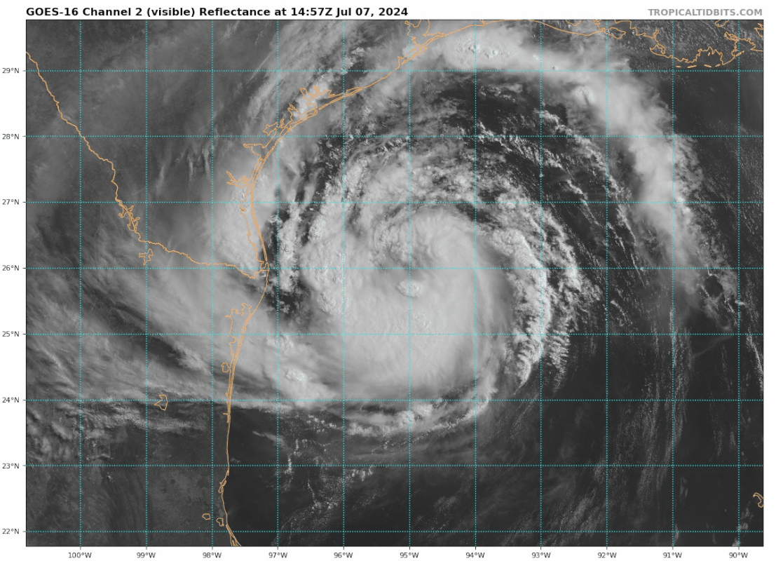
Getting better organized, and the eye looks like it will start as a much wider eye than we are used to from Beryl.
1 likes
-
tolakram
- Admin

- Posts: 20186
- Age: 62
- Joined: Sun Aug 27, 2006 8:23 pm
- Location: Florence, KY (name is Mark)
Re: ATL: BERYL - Tropical Storm - Discussion
Center is exposed at the moment.

4 likes
M a r k
- - - - -
Join us in chat: Storm2K Chatroom Invite. Android and IOS apps also available.
The posts in this forum are NOT official forecasts and should not be used as such. Posts are NOT endorsed by any professional institution or STORM2K.org. For official information and forecasts, please refer to NHC and NWS products.
Re: ATL: BERYL - Tropical Storm - Discussion
kevco wrote:HurricaneBrain wrote:My eyes see a N movement on radar and satellite. NHC says NW still and I’m not seeing that.
It Wiil likely make landfall on TX/ LA border midday on Monday. After a. Stall the direction usually go’s more N then NE.
0 likes
-
USTropics
- Professional-Met

- Posts: 2741
- Joined: Sun Aug 12, 2007 3:45 am
- Location: Florida State University
Re: ATL: BERYL - Tropical Storm - Discussion
Wampadawg wrote:abk_0710 wrote:crimi481 wrote:It may stall - go NE and miss Texas?
Is this an actual scenario?
Unlikely
I dislike using absolutes as well, but in this situation there is no chance of this stalling or not landfalling in Texas. Taking a step back and looking at the bigger picture, below is an outline of the current steering mechanisms with WV imagery (which we can depict based on our upper-level flow). Orange outlines our ridge, set by the high pressure off the NE coast and currently being pinched by the ULL off the East Coast. The pacific ridge is currently extending down towards Mexico. Our trough over the Midwest (blue) extends all the way down towards Oklahoma and is creating the break in the ridge that will steer Beryl to the north. While wobbles will play a role here, I've outlined two potential tracks in yellow; (1) the western edge (likely a weak storm will take this track) and (2) the more eastern edge (a stronger storm):

Animated loop:

If we analyze the upper-level flow at 250mb on the GFS for 2PM ET today, we can again see the eastern edge extension of the ridge (which will ensure Beryl makes landfalling in Texas) in orange. I've also outlined the upper-level jetstream here, which will (1) help ventilate Beryl as it approaches the coastline and (2) cause Beryl to move towards the NE after it makes landfall. If there is a 'stall' per se, it will be the remains of Beryl after it reaches up in the Great Lakes region and a blocking high emerges:

19 likes
-
tolakram
- Admin
- Posts: 20186
- Age: 62
- Joined: Sun Aug 27, 2006 8:23 pm
- Location: Florence, KY (name is Mark)
Re: ATL: BERYL - Tropical Storm - Discussion
closeup

8 likes
M a r k
- - - - -
Join us in chat: Storm2K Chatroom Invite. Android and IOS apps also available.
The posts in this forum are NOT official forecasts and should not be used as such. Posts are NOT endorsed by any professional institution or STORM2K.org. For official information and forecasts, please refer to NHC and NWS products.
- - - - -
Join us in chat: Storm2K Chatroom Invite. Android and IOS apps also available.
The posts in this forum are NOT official forecasts and should not be used as such. Posts are NOT endorsed by any professional institution or STORM2K.org. For official information and forecasts, please refer to NHC and NWS products.
-
MEANINGLESS_NUMBERS
- Category 2
- Posts: 503
- Joined: Mon Nov 02, 2020 1:43 pm
Re: ATL: BERYL - Tropical Storm - Discussion
tolakram wrote:closeup
https://i.imgur.com/HDMa0Pz.gif
Exposed CoC. Not much progress if this is meant to be a hurricane by tomorrow morning.
1 likes
Emily '87, Felix '95, Gert '99, Fabian '03, Humberto '19, Paulette '20, Teddy '20, Fiona '22, Lee '23, Ernesto '24, Humberto/Imelda '25
-
cheezyWXguy

- Category 5

- Posts: 6282
- Joined: Mon Feb 13, 2006 12:29 am
- Location: Dallas, TX
Re: ATL: BERYL - Tropical Storm - Discussion
Hurricane Mike wrote:Getting better organized, and the eye looks like it will start as a much wider eye than we are used to from Beryl.
Once the eye comes together, it should be a fair bit smaller than now, but yeah still bigger than we’ve seen with Beryl up to this point. Radar shows that banding is establishing itself progressively closer to the center with time, so I don’t expect to see that 48nm eye figure next time recon flies in. Shot in the dark, maybe 30-35nm?
1 likes
Re: ATL: BERYL - Tropical Storm - Discussion
New video from Levi https://www.youtube.com/watch?v=r12grs3qd1g
Link: https://youtube.com/watch?v=r12grs3qd1g
Link: https://youtube.com/watch?v=r12grs3qd1g
Last edited by tolakram on Sun Jul 07, 2024 11:12 am, edited 1 time in total.
Reason: added correct link with youtube tag
Reason: added correct link with youtube tag
3 likes

Re: ATL: BERYL - Tropical Storm - Discussion
MEANINGLESS_NUMBERS wrote:tolakram wrote:closeup
https://i.imgur.com/HDMa0Pz.gif
Exposed CoC. Not much progress if this is meant to be a hurricane by tomorrow morning.
It’s likely going to pulse today then burst again tonight. 2 isn’t out of the question but I think low low chances. Likely getting to a 1. I’d give it 70% 1, 28% TS and 2% 2.
2 likes
-
Craters
- Category 1

- Posts: 428
- Joined: Sat Aug 24, 2013 2:34 pm
- Location: Alvin, TX (south of Houston)
Re: ATL: BERYL - Tropical Storm - Discussion
That big outer band across the TX-LA border just dumped on us in Brazoria County. Feels very tropical-storm-like out there. Humid as all get-out, not as hot as it was yesterday ahead of everything. Light breezes.
4 likes
Nothing that I post here should ever be treated as a forecast or anything resembling one. Please check with your local NWS office or the NHC for forecasts, watches, and warnings.
-
Blown Away

- S2K Supporter
- Posts: 10253
- Joined: Wed May 26, 2004 6:17 am
Re: ATL: BERYL - Tropical Storm - Discussion
Beryl is shaping up nicely but a big slug of dry air near the center…
2 likes
Hurricane Eye Experience: David 79, Irene 99, Frances 04, Jeanne 04, Wilma 05… Hurricane Brush Experience: Andrew 92, Erin 95, Floyd 99, Matthew 16, Irma 17, Ian 22, Nicole 22…

Re: ATL: BERYL - Tropical Storm - Discussion
ROCK wrote:chaser1 wrote:Presentation on satellite is becoming quite respectable and evolving significantly more "traditional" then the very small inner core I had anticipated 12 hours ago. That said, I still would be very surprised for Beryl to deepen substantially and exceed a Cat 1 for the simple fact that it's challenging to expect a 40+ mile wide eye to significantly contract in a 24 hr period. Even with slow steady pressure falls the increase in winds typically lag a bit.
IDK Humberto RI closer than this to the coast into a Cat 1...very similar. But yes winds do lag after pressure drop.
Very true, Rock. On the other hand, wasn't Humberto relatively small with something like a 2-4 mile wide eye? I could be mistaken but I'm pretty sure it's inner core was far tighter then Beryl's 40 mile wide center. That was nearly 20 years ago; I have a tough time recollecting what I ate for dinner last night
4 likes
Andy D
(For official information, please refer to the NHC and NWS products.)
(For official information, please refer to the NHC and NWS products.)
-
IsabelaWeather
- Category 1
- Posts: 316
- Age: 36
- Joined: Tue Jul 07, 2020 7:29 am
- Location: Isabela, Puerto Rico
Re: ATL: BERYL - Hurricane - Discussion
capNstorms wrote:HoustonFrog wrote:capNstorms wrote:
"Pro mets in Houston are very confident that Beryl isn't much of a risk to Galveston"
oh have the tables have turned
SCW screwed up bad. About four days ago they said it may results in some rain and wrote it off. Even yesterday said impacts manageable and now this morning saying significant impacts with likely heavy power outages.
Big whiff
SETX mets took a big whiff as well, told everyone we were goooood and it was going to mexico/southern texas just before july 4th, no one is thinking about this storm, until now.....
I don't think we need this crap on the forums. This shouldnt be a place to criticize professional mets who have to balance public opinion and public awareness. 4 days ago it looked like the storm was going to tampico, there is no reason to start talking about a galveston landfall. That unnecessarily frightens people. You guys are making "forecasts" with hindsight 2020 as if it were obvious where the storm was going to go.
Many people here also have no risk whatsoever by just throwing out calls. Sure sometimes you get it right when you just check darts randomly at the dartboard.
4 likes
-
ScottNAtlanta

- Category 5
- Posts: 2535
- Joined: Sat May 25, 2013 3:11 pm
- Location: Atlanta, GA
Re: ATL: BERYL - Tropical Storm - Discussion
On the IR view you can see that there is some new convection wrapping around the north side trying to close the center

3 likes
The posts in this forum are NOT official forecast and should not be used as such. They are just the opinion of the poster and may or may not be backed by sound meteorological data. They are NOT endorsed by any professional institution or storm2k.org. For official information, please refer to the NHC and NWS products.
-
typhoonty
- Tropical Storm

- Posts: 121
- Age: 31
- Joined: Wed May 31, 2017 10:37 pm
- Location: Fort Myers / Tallahassee, FL
- Contact:
Re: ATL: BERYL - Tropical Storm - Discussion
Charleswachal wrote:toad strangler wrote:CypressMike wrote:
It would have to be a terribly bad forecast to actually leave the cone of error before the cone was updated! But yeah, the current path is taking Beryl over areas that were previously outside the cone of error.
That was my main question. I just heard differently. Obviously the cone is always shifting but did that center ever actually leave a previous release of the cone? I’m sure someone will track that in detail.
I think for the most part the NHC will always be able to keep it inside the cone for a 6 hour window. The question is was the landfall location outside of the cone and I would have to look back on previous cones to check. I believe at one point the cone was completely in the south and that Houston was not in the cone at all.
If the center is east of Port O’Connors longitude at 2AM, it will be east of the NHCs Wednesday 5AM cone. It’s theoretically possible it stays in, but it would have to take the left end of the current cone.
I’ve had a 90 kt landfall/967 at Freeport since Thursday 14Z. Which would be outside of their cone.
1 likes
FSU Meteorology student, opinions are mine, 20 years experience covering TC's, consult NHC/Local officials when making decisions.
Gabrielle '01, Michelle '01, Charley '04, Frances '04, Dennis '05, Katrina '05, Rita '05, Wilma '05, Fay '08, Isaac '12 Hermine '16, Irma '17, Michael '18, Eta '20, Elsa '21, IAN '22, Idalia '23, Debby '24, Helene '24
Gabrielle '01, Michelle '01, Charley '04, Frances '04, Dennis '05, Katrina '05, Rita '05, Wilma '05, Fay '08, Isaac '12 Hermine '16, Irma '17, Michael '18, Eta '20, Elsa '21, IAN '22, Idalia '23, Debby '24, Helene '24
-
wxman22

- Category 5
- Posts: 2008
- Joined: Mon Jan 30, 2006 12:39 am
- Location: Wichita Falls, TX
- Contact:
Re: ATL: BERYL - Tropical Storm - Discussion
kevco wrote:HurricaneBrain wrote:My eyes see a N movement on radar and satellite. NHC says NW still and I’m not seeing that.
It Wii’s likely make landfall on TX/ LA border midday on Monday. After a. Stall the direction usually go’s more N then NE.
This is not going to Louisiana there sure is a lot of -removed- with this storm for some reason.
8 likes
Who is online
Users browsing this forum: No registered users and 32 guests