ATL: BERYL - Post-Tropical - Discussion
Moderator: S2k Moderators
-
MarioProtVI
- Category 5

- Posts: 1039
- Age: 24
- Joined: Sun Sep 29, 2019 7:33 pm
- Location: New Jersey
-
cycloneye

- Admin

- Posts: 149719
- Age: 69
- Joined: Thu Oct 10, 2002 10:54 am
- Location: San Juan, Puerto Rico
Re: ATL: BERYL - Tropical Storm - Discussion
Ok folks, let's return to comment about tropical storm Beryl as it approaches the Texas coast.
https://x.com/HoustonChron/status/1810033570519363854
https://x.com/HoustonChron/status/1810033570519363854
1 likes
Visit the Caribbean-Central America Weather Thread where you can find at first post web cams,radars
and observations from Caribbean basin members Click Here
and observations from Caribbean basin members Click Here

Re: ATL: BERYL - Hurricane - Discussion
IsabelaWeather wrote:Nederlander wrote:IsabelaWeather wrote:
I don't think we need this crap on the forums. This shouldnt be a place to criticize professional mets who have to balance public opinion and public awareness. 4 days ago it looked like the storm was going to tampico, there is no reason to start talking about a galveston landfall. That unnecessarily frightens people. You guys are making "forecasts" with hindsight 2020 as if it were obvious where the storm was going to go.
Many people here also have no risk whatsoever by just throwing out calls. Sure sometimes you get it right when you just check darts randomly at the dartboard.
Some criticism is fair and warranted. There’s way too much model hugging and not enough old fashioned meteorology. The problem is that there were signs fairly early on that some models were picking up on (namely the ICON, Navy, and JWA) that the ridge could break down, but the typical favorite models weren’t giving into that.
The other problem is when Mets (and the general public) use definitive statements instead of probabilities.
There’s no way to sugarcoat this one. This was a rather big miss for models and also some mets who were convinced this was a Mexico issue.
That isn't true. There were plenty of meteorological reasons the storm could have went into CA or Mexico. The longwave trough could easily have moved slower, the big thing here is beryl was stronger and more resilient to the shear. Turned the TUTT into a retrograding upperlevel low. Had it been disrupted then it would have went SW to W into CA or Mex. Take the exact same scenario you could easily have had a disrupted storm that did not behave like Beryl. Sometimes there are randomness you cant forecast or maybe there is something we still don't fully understand.
You are just using the benefit of hindsight to make it sound so obvious.
I also don't think the models busted that badly, there were many ensemble members that took the track it ended up taking, the NHC track was pretty darn good from the outset.
Not to pick apart your opinion but the models played catch up for the last 5 days to the ICON, JMA even the crappy NAVGEM..as did the NHC.
9 likes
Re: ATL: BERYL - Tropical Storm - Discussion
Still has about 14 hours give or take over water. Plenty of time to still reach hurricane strength.
3 likes
-
capNstorms
- Tropical Storm

- Posts: 128
- Age: 33
- Joined: Mon Jun 14, 2021 12:48 pm
- Location: Beaumont, TX
Re: ATL: BERYL - Tropical Storm - Discussion
GCANE wrote:CAPE 9500!
Never seen it this high before
larger CAPE produces more vigorous
convection, which promotes more lightning (Williams et al. 1992; Rutledge et al. 1992)
3 likes
-
lilbump3000

- Category 4

- Posts: 966
- Age: 38
- Joined: Sat Sep 20, 2003 10:09 am
- Location: New Orleans, Louisiana
- Contact:

Re: ATL: BERYL - Tropical Storm - Discussion
As of right now, this isn’t a system capable of rapid intensification. I don’t care what it did previously, it seems to have been permanently disrupted by land interaction. This isn’t unusual, and something that has been seen many times before. I keep reading “just a few more hours” on here, but those hours are now running thin. This is comparatively more organized that yesterday, but not organized to see a quickly intensifying hurricane. At this point, the meager pressure drops are likely resulting in an expanding wind field (as I’ve been saying for 48 hours now) and not an increase in max winds.
8 likes
Re: ATL: BERYL - Tropical Storm - Discussion
wx98 wrote:As of right now, this isn’t a system capable of rapid intensification. I don’t care what it did previously, it seems to have been permanently disrupted by land interaction. This isn’t unusual, and something that has been seen many times before. I keep reading “just a few more hours” on here, but those hours are now running thin. This is comparatively more organized that yesterday, but not organized to see a quickly intensifying hurricane. At this point, the meager pressure drops are likely resulting in an expanding wind field (as I’ve been saying for 48 hours now) and not an increase in max winds.
I hope you're right we shall see.
5 likes
-
capNstorms
- Tropical Storm
- Posts: 128
- Age: 33
- Joined: Mon Jun 14, 2021 12:48 pm
- Location: Beaumont, TX

-
Blown Away

- S2K Supporter

- Posts: 10253
- Joined: Wed May 26, 2004 6:17 am
Re: ATL: BERYL - Tropical Storm - Discussion
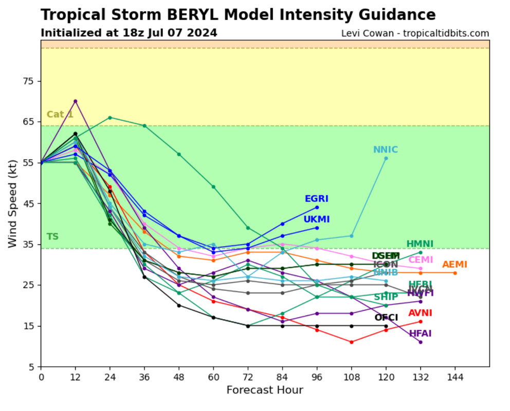
18z Intensity Guidance keeping Beryl mostly at TS.
1 likes
Hurricane Eye Experience: David 79, Irene 99, Frances 04, Jeanne 04, Wilma 05… Hurricane Brush Experience: Andrew 92, Erin 95, Floyd 99, Matthew 16, Irma 17, Ian 22, Nicole 22…
Re: ATL: BERYL - Tropical Storm - Discussion
wx98 wrote:As of right now, this isn’t a system capable of rapid intensification. I don’t care what it did previously, it seems to have been permanently disrupted by land interaction. This isn’t unusual, and something that has been seen many times before. I keep reading “just a few more hours” on here, but those hours are now running thin. This is comparatively more organized that yesterday, but not organized to see a quickly intensifying hurricane. At this point, the meager pressure drops are likely resulting in an expanding wind field (as I’ve been saying for 48 hours now) and not an increase in max winds.
Please research Humberto 2007. The fastest RI on record. TD to TS in 3 hrs then TD to high end Cat 1 with 15 miles
Before landfall in HS at 90mph
7 likes
Re: ATL: BERYL - Hurricane - Discussion
IsabelaWeather wrote:Nederlander wrote:IsabelaWeather wrote:
I don't think we need this crap on the forums. This shouldnt be a place to criticize professional mets who have to balance public opinion and public awareness. 4 days ago it looked like the storm was going to tampico, there is no reason to start talking about a galveston landfall. That unnecessarily frightens people. You guys are making "forecasts" with hindsight 2020 as if it were obvious where the storm was going to go.
Many people here also have no risk whatsoever by just throwing out calls. Sure sometimes you get it right when you just check darts randomly at the dartboard.
Some criticism is fair and warranted. There’s way too much model hugging and not enough old fashioned meteorology. The problem is that there were signs fairly early on that some models were picking up on (namely the ICON, Navy, and JWA) that the ridge could break down, but the typical favorite models weren’t giving into that.
The other problem is when Mets (and the general public) use definitive statements instead of probabilities.
There’s no way to sugarcoat this one. This was a rather big miss for models and also some mets who were convinced this was a Mexico issue.
That isn't true. There were plenty of meteorological reasons the storm could have went into CA or Mexico. The longwave trough could easily have moved slower, the big thing here is beryl was stronger and more resilient to the shear. Turned the TUTT into a retrograding upperlevel low. Had it been disrupted then it would have went SW to W into CA or Mex. Take the exact same scenario you could easily have had a disrupted storm that did not behave like Beryl. Sometimes there are randomness you cant forecast or maybe there is something we still don't fully understand.
You are just using the benefit of hindsight to make it sound so obvious.
I also don't think the models busted that badly, there were many ensemble members that took the track it ended up taking, the NHC track was pretty darn good from the outset.
It was a late August setup in June/July. Beryl has been a mysterious record breaker from the beginning. It's a storm that will be studied for years.
5 likes

Re: ATL: BERYL - Tropical Storm - Discussion
IcyTundra wrote:Still has about 14 hours give or take over water. Plenty of time to still reach hurricane strength.
Or to top up gas for your generator and finish those last minute preps.
Pressure dropped from 991 to 990 last recon pass.
With just a slow deepening the 970's could be reached.
Also tracking a little more N towards Freeport and a NNE heading is even possible.
Glad the structure hasn't lent itself to rapid intensification so far but wish it was inland already..
4 likes
-
cycloneye
- Admin
- Posts: 149719
- Age: 69
- Joined: Thu Oct 10, 2002 10:54 am
- Location: San Juan, Puerto Rico
Re: ATL: BERYL - Tropical Storm - Discussion
5 likes
Visit the Caribbean-Central America Weather Thread where you can find at first post web cams,radars
and observations from Caribbean basin members Click Here
and observations from Caribbean basin members Click Here
Re: ATL: BERYL - Tropical Storm - Discussion
Blown Away wrote:[url]https://i.postimg.cc/RhNxFVYr/IMG-7723.jpg [/url]
18z Intensity Guidance keeping Beryl mostly at TS.
Hurricane models aren't showing up on there you can go check the 12Z HWRF, HMON, HAFS-A, and HAFS-B they all show Beryl strengthening to a hurricane.
1 likes
Re: ATL: BERYL - Tropical Storm - Discussion
Blown Away wrote:[url]https://i.postimg.cc/RhNxFVYr/IMG-7723.jpg [/url]
18z Intensity Guidance keeping Beryl mostly at TS.
Being here in Brazoria I hope that it doesn’t,
Thats my wish cast lol
3 likes
Harvey,Hanna,Beta,Texas Winter storm2021,Nicholas,Beryl
-
ElectricStorm

- Category 5
- Posts: 5155
- Age: 25
- Joined: Tue Aug 13, 2019 11:23 pm
- Location: Norman, OK
Re: ATL: BERYL - Tropical Storm - Discussion
Just an amateur observation but looking at radar it just seems like the center is too broad for any significant strengthening before landfall. I still don't think this will be any higher than minimal Cat 1 at the most, maybe high end TS. Would need to start tightening up like right now if it's going to get any stronger than that IMO.
5 likes
B.S Meteorology, University of Oklahoma '25
Please refer to the NHC, NWS, or SPC for official information.
Please refer to the NHC, NWS, or SPC for official information.
Re: ATL: BERYL - Tropical Storm - Discussion
capNstorms wrote:GCANE wrote:CAPE 9500!
Never seen it this high before
larger CAPE produces more vigorous
convection, which promotes more lightning (Williams et al. 1992; Rutledge et al. 1992)
thankfully it's nowhere near where beryl is tho
0 likes

Re: ATL: BERYL - Tropical Storm - Discussion
wx98 wrote:As of right now, this isn’t a system capable of rapid intensification. I don’t care what it did previously, it seems to have been permanently disrupted by land interaction. This isn’t unusual, and something that has been seen many times before. I keep reading “just a few more hours” on here, but those hours are now running thin. This is comparatively more organized that yesterday, but not organized to see a quickly intensifying hurricane. At this point, the meager pressure drops are likely resulting in an expanding wind field (as I’ve been saying for 48 hours now) and not an increase in max winds.
I do doubt this unfortunately, we have seen time and time again this storm does what is unexpected. Guess we will see, but still thinking it's going to a cat 2 at landfall.
1 likes
-
tolakram
- Admin
- Posts: 20186
- Age: 62
- Joined: Sun Aug 27, 2006 8:23 pm
- Location: Florence, KY (name is Mark)
Re: ATL: BERYL - Tropical Storm - Discussion
The latest HWRF has this at 982 by 8pm. I think that's the metric to go on if rapid intensification is to be believed, otherwise chances for more than a cat 1 drop quickly, fortunately.
9 likes
M a r k
- - - - -
Join us in chat: Storm2K Chatroom Invite. Android and IOS apps also available.
The posts in this forum are NOT official forecasts and should not be used as such. Posts are NOT endorsed by any professional institution or STORM2K.org. For official information and forecasts, please refer to NHC and NWS products.
Who is online
Users browsing this forum: Google Adsense [Bot] and 56 guests