2024 Indicators: SST's, MSLP, Shear, SAL, Steering, Instability (Day 16+ Climate Models)

This is the general tropical discussion area. Anyone can take their shot at predicting a storms path.

Moderator: S2k Moderators

Forum rules

The posts in this forum are NOT official forecasts and should not be used as such. They are just the opinion of the poster and may or may not be backed by sound meteorological data. They are NOT endorsed by any professional institution or STORM2K. For official information, please refer to products from the National Hurricane Center and National Weather Service.

Help Support Storm2K
Message
Author
User avatar
Ubuntwo
Category 5
Category 5
Posts: 1406
Age: 31
Joined: Thu Oct 05, 2017 10:41 pm

Re: 2024 Indicators: SST's, MSLP, Shear, SAL, Steering, Instability (Day 16+ Climate Models)

#1521 Postby Ubuntwo » Mon Jul 15, 2024 8:41 am

zzzh wrote:
WaveBreaking wrote:Looks like the Newfoundland warm blob might actually reduce the chances of wave breaking this year.

 https://x.com/wxtca/status/1812584195748696494


https://i.imgur.com/V5gGUzG.png
Does it? I don't have a PVS frequency anomaly map but the 200mb vorticity should work as well: You can clearly see the enhanced anticyclonic wavebreaking near 30N, which is the opposite of what the 'bottom PVS' figure shows. I wonder if anyone has the link to the paper? I would like to read it.

You’re comparing a single month from the early season to a whole-season average. The graphic aims to establish the predictive power of SST anomalies, not their hindcast potential. The paper is Papin’s dissertation on PVS, it’s not freely available but you may have access through a university. I imagine he would also be more than willing to send a copy if you shoot him a message.
2 likes   
Kendall -> SLO -> PBC

Memorable Storms: Katrina (for its Florida landfall...) Wilma Matthew Irma

zzzh
Category 3
Category 3
Posts: 834
Joined: Thu Sep 02, 2021 1:13 pm

Re: 2024 Indicators: SST's, MSLP, Shear, SAL, Steering, Instability (Day 16+ Climate Models)

#1522 Postby zzzh » Mon Jul 15, 2024 10:12 am

Ubuntwo wrote:You’re comparing a single month from the early season to a whole-season average. The graphic aims to establish the predictive power of SST anomalies, not their hindcast potential. The paper is Papin’s dissertation on PVS, it’s not freely available but you may have access through a university. I imagine he would also be more than willing to send a copy if you shoot him a message.

Thanks, I found it :D
From Papin's paper: there is a strong correlation between June-July PVSI and ASON PVSI.
Image
Also the 8 years with lowest PVSI are 1998 1999 2010 1995 1988 2006 1979 2001, 4 of those years are hyperactive. I plotted the non-hyperactive minus hyperactive years.
Image
2 likes   

User avatar
WaveBreaking
Category 2
Category 2
Posts: 578
Joined: Sun Jun 30, 2024 11:33 am
Location: US

Re: 2024 Indicators: SST's, MSLP, Shear, SAL, Steering, Instability (Day 16+ Climate Models)

#1523 Postby WaveBreaking » Mon Jul 15, 2024 10:24 am

zzzh wrote:
WaveBreaking wrote:Looks like the Newfoundland warm blob might actually reduce the chances of wave breaking this year.

 https://x.com/wxtca/status/1812584195748696494


https://i.imgur.com/V5gGUzG.png
Does it? I don't have a PVS frequency anomaly map but the 200mb vorticity should work as well: You can clearly see the enhanced anticyclonic wavebreaking near 30N, which is the opposite of what the 'bottom PVS' figure shows. I wonder if anyone has the link to the paper? I would like to read it.


I couldn’t find the original paper, but the same poster plotted ACE anomalies for the 10 years where the Newfoundland warm blob was at its warmest; 5 are hyperactive years. So regardless of how much the warm blob correlates to PV streamer activity, it also correlates to above-average ACE in the gulf and caribbean, which we have seen already. It also hints at some OTS tracks which is hopeful.

 https://x.com/wxtca/status/1812588320695652803

0 likes   
I am NOT a professional meteorologist, so take all of my posts with a grain of salt. My opinions are mine and mine alone.

USTropics
Professional-Met
Professional-Met
Posts: 2650
Joined: Sun Aug 12, 2007 3:45 am
Location: Florida State University

Re: 2024 Indicators: SST's, MSLP, Shear, SAL, Steering, Instability (Day 16+ Climate Models)

#1524 Postby USTropics » Mon Jul 15, 2024 10:29 am

Ubuntwo wrote:
zzzh wrote:
WaveBreaking wrote:Looks like the Newfoundland warm blob might actually reduce the chances of wave breaking this year.

 https://x.com/wxtca/status/1812584195748696494


https://i.imgur.com/V5gGUzG.png
Does it? I don't have a PVS frequency anomaly map but the 200mb vorticity should work as well: You can clearly see the enhanced anticyclonic wavebreaking near 30N, which is the opposite of what the 'bottom PVS' figure shows. I wonder if anyone has the link to the paper? I would like to read it.

You’re comparing a single month from the early season to a whole-season average. The graphic aims to establish the predictive power of SST anomalies, not their hindcast potential. The paper is Papin’s dissertation on PVS, it’s not freely available but you may have access through a university. I imagine he would also be more than willing to send a copy if you shoot him a message.


Some excerpts from Papin's PHD dissertation:

3.4.2 NATL MDR SSTs
Another factor proposed to influence PVS activity in the Atlantic basin is changes in yearly SST anomalies in the Atlantic basin MDR, because SST changes modulate convective activity that can erode the southern extent of low-latitude PVSs. For this investigation, the composite PVS frequency anomaly for the lowest eight SST anomalies and highest eight SST anomalies years (corresponding to the bottom and top 20th percentiles) in the NATL basin MDR are plotted in Fig. 3.19, using SST anomaly data from Kaplan et al. (1998) extended to 2015, where the MDR is defined between 10–20o N and 20–80W (see Fig. 3.3), a location where TC development is common in the Atlantic basin (e.g., Gray 1968; Zhang et al. 2017).

In low SST anomaly years, there is a notable increase in PVS frequency relative to climatology with the greatest anomalies (+4–6%) observed along the equatorward flank of the climatological PVS frequency maximum around 25N in the Atlantic basin (Fig. 3.19a). The inverse is true for high SST anomaly years, where a -4–6% anomaly relative to climatology is present in roughly the same location in the Atlantic basin (Fig. 3.19b). A possible explanation for this inverse relationship in SST anomaly relative to PVS frequency could be related to the presumption that higher MDR SST anomalies in the Atlantic basin would promote more deep, moist, convection between 10–20N. The outflow from this convection could, therefore, impinge on PVS activity occurring poleward, and act to destroy upper-tropospheric positive PV anomalies. The opposite would be true for low SST anomaly years, where implied suppressed convective activity may allow PVSs with higher-PV air to penetrate equatorward in the Atlantic basin. When comparing MDR SST anomalies to PVSI, a moderate negative correlation is observed (r = -0.43; Fig. 3.20). A large year-to-year spread exists, however, and two of the three highest PVS activity index years feature MDR SST anomalies that are on the warmer end of the 37-y spectrum. Again, PVSs appear to influenced by more than simply MDR SST variations. One additional SST-based index that is explored in chapter 5 is the AMO, where additional context will be provided since the AMO has also been shown to significantly affect TC activity on low frequency timescales (Klotzbach and Gray 2008).

5.3.2. Spatial pattern of top and bottom ACE and PVS activity years So far we have documented statistical correlations between PVSI and ACE, and how the number of PVSs change in top and bottom ACE years. It is also illuminating, however, to plot correlations between PVS frequency and ACE in a spatial sense (Fig. 5.4). Over most of the NATL basin, a negative correlation exists between PVS frequency and ACE, though this negative correlation increases in magnitude (between -0.3 to -0.6) and is statistically significant mainly equatorward of 30N in the western NATL basin. This area is associated with the most

TC activity as evidenced by the wide swath of climatological ACE between 2–6×10⁴ kt2 spanning the region. The negative correlation in this region signifies that lower ACE is observed as PVS frequency increases over this part of the domain. To further confirm the relationship between PVS frequency and ACE, Fig. 5.5 shows yearly PVS frequency anomalies relative to climatology for bottom and top ACE years. Not surprisingly, bottom ACE years exhibit an expansive area (70–30W) of statistically significant positive PVS frequency anomalies (between +3 to +6%) relative to climatology, mostly equatorward of the climatological PVS occurrence maximum (Fig. 5.4a). One interpretation of this map is that the time-mean TUTT axis in these seasons may be stronger and displaced equatorward closer to the MDR in the NATL basin, which is associated with enhanced VWS equatorward of the TUTT and suppressed moisture along the TUTT axis (Fitzpatrick et al. 1995; Knaff 1997).

In contrast, top ACE years exhibit an expansive area (70–30W) of statistically significant negative PVS frequency anomalies (between -4 to -6%) relative to climatology, primarily equatorward of the climatological PVS occurrence maximum (Fig. 5.4a). In turn, the time-mean TUTT axis in these seasons may be weaker and displaced poleward away from the MDR in the NATL basin, which is associated with reduced VWS downstream of the TUTT axis (Fitzpatrick et al. 1995; Knaff 1997). To confirm the possible changes in environmental VWS and moisture described above, Fig. 5.6 illustrates composite difference plots of bottom ACE years minus top ACE years (see Table 5.2 for years used in each subset). The most prominent feature in Fig. 5.6a is the statistically significant dipole of enhanced westerly VWS between 10–20N across the NATL basin and a corresponding area of reduced VWS differences between 20–30N. This pattern depicts a cyclonic circulation of VWS vector differences, which is associated with the change from positive to negative PVS frequency anomalies between bottom and top ACE years in Fig. 5.5. In addition, this region is also associated with a statistically significant reduction in uppertropospheric thickness (Fig. 5.6b), precipitable water (Fig. 5.6c), and an enhancement of the sea level pressure (Fig. 5.6d) associated with 925-hPa anticyclonic flow differences. These differences in thickness, moisture, and sea level pressure link back to the stronger and larger PVS composites presented in Chapter 4 (Fig. 4.4, 4.7, 4.11, 4.14), which were previously noted to occur in higher frequency in bottom ACE years (Fig. 5.3). A lingering question that remains is if the same spatial patterns of these environmental variables also exists between top minus bottom PVSI years.

Figure 5.7 shows the same four variables described in Fig. 5.6, except for differences between top PVSI years minus bottom PVSI years. Once again, statistically significant enhancement of VWS is observed between 10–20N with an associated reduction in precipitatble water, upper-tropospheric thickness, and enhanced sea level pressure centered around 20N. Note that while the variable differences between high minus low PVSI years are similar to bottom minus top ACE years, the yearly composite subsets are not identical, since only four years are shared between top ACE, bottom PVSI and bottom ACE, top PVSI. Subtle differences do exist in the VWS, thickness, precipitable water, and sea level pressure differences, which all appear to shift further east in the NATL basin versus what is observed in Fig. 5.6. The general pattern remains, however, where cyclonic VWS differences, lower thickness, lower precipitable water, and enhanced sea level pressure around 20N appear to occur in conjunction with increased PVS activity in the NATL basin. Focusing on the region where TC activity is most prevalent, VWS and precipitable water for each year is averaged in a box between 10–30N and 20-90W to see if there are significant changes in this region associated with yearly PVSI.

Figure 5.8 shows a scatter plot of both variables versus PVSI. For VWS (Fig. 5.8a) there is a moderate positive correlation (r = 0.49) where increasing PVSI generally results in an increase in VWS where TCs frequently occur in the NATL basin (Fig. 5.4, ACE climatology in black contours). In contrast, precipitable water in this same domain exhibits a moderate negative correlation (r = -0.43) where increasing PVSI generally results in a decrease in precipitable water where TCs frequently occur in in the NATL basin. The top and bottom ACE years are also depicted as red and blue dots in both plots in Fig. 5.8. These years illustrate that significant variability in VWS and precipitatble water can still occur, even among yearly subsets associated with top and bottom ACE, respectively. Overall, the results presented in this section fall in line with the results presented in Zhang et al. (2017, see Fig. 1.9 in Chapter 1), with a few exceptions. For instance, PVS intensity variations can modify the relationship between PVS activity and TC activity (e.g., Fig. 5.1 c–d). Thus, using a metric such as PVSI provides added value by incorporating size and intensity of PVSs into its overall quantity, and produces the strongest negative correlation (Fig. 5.2), even though its relationship with TC activity is not linear. Higher PVSI years are associated with larger and stronger PVSs, which increase VWS and decrease precipitatble water in low latitudes (Figs. 5.7, 5.8). These negative environmental factors explain why the strongest negative correlation between PVS frequency and ACE occurs between 10–30 N mostly west of 40W (Fig. 5.4). The latter result suggests that different modes and locations of TCG may influence the correlation between PVSs and TCs, which will be explored in section 5.6.

Image
Image
Image
Image
Image
10 likes   

User avatar
Ubuntwo
Category 5
Category 5
Posts: 1406
Age: 31
Joined: Thu Oct 05, 2017 10:41 pm

Re: 2024 Indicators: SST's, MSLP, Shear, SAL, Steering, Instability (Day 16+ Climate Models)

#1525 Postby Ubuntwo » Mon Jul 15, 2024 10:35 am

zzzh wrote:
Ubuntwo wrote:You’re comparing a single month from the early season to a whole-season average. The graphic aims to establish the predictive power of SST anomalies, not their hindcast potential. The paper is Papin’s dissertation on PVS, it’s not freely available but you may have access through a university. I imagine he would also be more than willing to send a copy if you shoot him a message.

Thanks, I found it :D
From Papin's paper: there is a strong correlation between June-July PVSI and ASON PVSI.
https://i.imgur.com/zBL8ZKU.jpeg
Also the 8 years with lowest PVSI are 1998 1999 2010 1995 1988 2006 1979 2001, 4 of those years are hyperactive. I plotted the non-hyperactive minus hyperactive years.
https://i.imgur.com/FOb1ShN.png

Cool! I’m curious, is there a PVSI readout floating around out there? Could also write a python script if not. I’m also wondering what the overall June/July PVS look for 2005, 1998, 1933, 2017, etc. was
1 likes   
Kendall -> SLO -> PBC

Memorable Storms: Katrina (for its Florida landfall...) Wilma Matthew Irma

User avatar
ScottNAtlanta
Category 5
Category 5
Posts: 2367
Joined: Sat May 25, 2013 3:11 pm
Location: Atlanta, GA

Re: 2024 Indicators: SST's, MSLP, Shear, SAL, Steering, Instability (Day 16+ Climate Models)

#1526 Postby ScottNAtlanta » Mon Jul 15, 2024 10:42 am

al78 wrote:I can understand some of the skepticism regarding the extreme seasonal forecasts given activity has been non-existant since Beryl. We have to remember that July is normally very quiet and maybe we should not try to predict the whole season based on the lack of activity in the last two weeks. Phil said he expects the Atlantic to be quiet for now then a pickup in the last week of July based on extremely conducive lower and upper-level wind anomalies combined with the MJO moving into phase 1 and 2 which is favourable for TC genesis in the Atlantic.

A forecast bust is unlikely but not impossible. Seasonal forecasts do not predict hurricanes, they forecast how conducive the conditions in the tropics are for TC genesis and intensification, and relate that to how active hurricane seasons have been in the past under similar conditions using data going back several decades. This works the majority of the time but there are always random unpredictable factors that can throw a spanner in the works. ACE per storm can depend heavily on where that storm tracks and how much land it encounters, or whether it passes over the cold wake of another storm. An unusually active SAL can heavily suppress TC activity despite favourable SSTs and atmospheric winds. The intra-seasonal variability is very difficult or impossible to predict weeks or months in advance, e.g. August 2022.

One other thing I want to add to this. Strong SAL outbreaks can coincide with strong tropical waves coming off of Africa. The easterly flow (coming out of the east) on the top enhances dust coming off the coast. When there is SAL, you look at the wave that is going to come off AFTER the wave pushing the dust off the coast. Those waves, if they are strong, are most likely to develop. The front runner sacrifices itself to moisten the column for the next wave. We have seen that many times.
6 likes   
The posts in this forum are NOT official forecast and should not be used as such. They are just the opinion of the poster and may or may not be backed by sound meteorological data. They are NOT endorsed by any professional institution or storm2k.org. For official information, please refer to the NHC and NWS products.

USTropics
Professional-Met
Professional-Met
Posts: 2650
Joined: Sun Aug 12, 2007 3:45 am
Location: Florida State University

Re: 2024 Indicators: SST's, MSLP, Shear, SAL, Steering, Instability (Day 16+ Climate Models)

#1527 Postby USTropics » Mon Jul 15, 2024 10:47 am

Ubuntwo wrote:
zzzh wrote:
Ubuntwo wrote:You’re comparing a single month from the early season to a whole-season average. The graphic aims to establish the predictive power of SST anomalies, not their hindcast potential. The paper is Papin’s dissertation on PVS, it’s not freely available but you may have access through a university. I imagine he would also be more than willing to send a copy if you shoot him a message.

Thanks, I found it :D
From Papin's paper: there is a strong correlation between June-July PVSI and ASON PVSI.
https://i.imgur.com/zBL8ZKU.jpeg
Also the 8 years with lowest PVSI are 1998 1999 2010 1995 1988 2006 1979 2001, 4 of those years are hyperactive. I plotted the non-hyperactive minus hyperactive years.
https://i.imgur.com/FOb1ShN.png

Cool! I’m curious, is there a PVSI readout floating around out there? Could also write a python script if not. I’m also wondering what the overall June/July PVS look for 2005, 1998, 1933, 2017, etc. was


Here is some data from 1980 - 2015. Would also be interested in a live PVSI feed but haven't seen one.
Image
2 likes   

User avatar
Ubuntwo
Category 5
Category 5
Posts: 1406
Age: 31
Joined: Thu Oct 05, 2017 10:41 pm

Re: 2024 Indicators: SST's, MSLP, Shear, SAL, Steering, Instability (Day 16+ Climate Models)

#1528 Postby Ubuntwo » Mon Jul 15, 2024 10:59 am

USTropics wrote:
Ubuntwo wrote:
zzzh wrote:Thanks, I found it :D
From Papin's paper: there is a strong correlation between June-July PVSI and ASON PVSI.
https://i.imgur.com/zBL8ZKU.jpeg
Also the 8 years with lowest PVSI are 1998 1999 2010 1995 1988 2006 1979 2001, 4 of those years are hyperactive. I plotted the non-hyperactive minus hyperactive years.
https://i.imgur.com/FOb1ShN.png

Cool! I’m curious, is there a PVSI readout floating around out there? Could also write a python script if not. I’m also wondering what the overall June/July PVS look for 2005, 1998, 1933, 2017, etc. was


Here is some data from 1980 - 2015. Would also be interested in a live PVSI feed but haven't seen one.
https://i.imgur.com/mqhFAiJ.png

I saw these plots in the paper as well, but they only break PVs down by an average over an entire season OR by month over the entire study period, and not both (by month and by season). If there is an implementation of his PVSI calculation or PV detection algorithm we could figure it out ourselves.
0 likes   
Kendall -> SLO -> PBC

Memorable Storms: Katrina (for its Florida landfall...) Wilma Matthew Irma

USTropics
Professional-Met
Professional-Met
Posts: 2650
Joined: Sun Aug 12, 2007 3:45 am
Location: Florida State University

Re: 2024 Indicators: SST's, MSLP, Shear, SAL, Steering, Instability (Day 16+ Climate Models)

#1529 Postby USTropics » Mon Jul 15, 2024 11:05 am

Ubuntwo wrote:
USTropics wrote:
Ubuntwo wrote:Cool! I’m curious, is there a PVSI readout floating around out there? Could also write a python script if not. I’m also wondering what the overall June/July PVS look for 2005, 1998, 1933, 2017, etc. was


Here is some data from 1980 - 2015. Would also be interested in a live PVSI feed but haven't seen one.
https://i.imgur.com/mqhFAiJ.png

I saw these plots in the paper as well, but they only break PVs down by an average over an entire season OR by month over the entire study period, and not both (by month and by season). If there is an implementation of his PVSI calculation or PV detection algorithm we could figure it out ourselves.


When I get back home Friday I'll look more into it, but this might be a good place to start: https://www.atmos.albany.edu/student/ppapin/lb13_img/phd/pvs_climo.html
0 likes   

User avatar
Hurricane2022
Category 5
Category 5
Posts: 1541
Joined: Tue Aug 23, 2022 11:38 pm
Location: Araçatuba, Brazil

Re: 2024 Indicators: SST's, MSLP, Shear, SAL, Steering, Instability (Day 16+ Climate Models)

#1530 Postby Hurricane2022 » Mon Jul 15, 2024 12:32 pm

USTropics wrote:
Ubuntwo wrote:
zzzh wrote:https://i.imgur.com/V5gGUzG.png
Does it? I don't have a PVS frequency anomaly map but the 200mb vorticity should work as well: You can clearly see the enhanced anticyclonic wavebreaking near 30N, which is the opposite of what the 'bottom PVS' figure shows. I wonder if anyone has the link to the paper? I would like to read it.

You’re comparing a single month from the early season to a whole-season average. The graphic aims to establish the predictive power of SST anomalies, not their hindcast potential. The paper is Papin’s dissertation on PVS, it’s not freely available but you may have access through a university. I imagine he would also be more than willing to send a copy if you shoot him a message.


Some excerpts from Papin's PHD dissertation:

3.4.2 NATL MDR SSTs
Another factor proposed to influence PVS activity in the Atlantic basin is changes in yearly SST anomalies in the Atlantic basin MDR, because SST changes modulate convective activity that can erode the southern extent of low-latitude PVSs. For this investigation, the composite PVS frequency anomaly for the lowest eight SST anomalies and highest eight SST anomalies years (corresponding to the bottom and top 20th percentiles) in the NATL basin MDR are plotted in Fig. 3.19, using SST anomaly data from Kaplan et al. (1998) extended to 2015, where the MDR is defined between 10–20o N and 20–80W (see Fig. 3.3), a location where TC development is common in the Atlantic basin (e.g., Gray 1968; Zhang et al. 2017).

In low SST anomaly years, there is a notable increase in PVS frequency relative to climatology with the greatest anomalies (+4–6%) observed along the equatorward flank of the climatological PVS frequency maximum around 25N in the Atlantic basin (Fig. 3.19a). The inverse is true for high SST anomaly years, where a -4–6% anomaly relative to climatology is present in roughly the same location in the Atlantic basin (Fig. 3.19b). A possible explanation for this inverse relationship in SST anomaly relative to PVS frequency could be related to the presumption that higher MDR SST anomalies in the Atlantic basin would promote more deep, moist, convection between 10–20N. The outflow from this convection could, therefore, impinge on PVS activity occurring poleward, and act to destroy upper-tropospheric positive PV anomalies. The opposite would be true for low SST anomaly years, where implied suppressed convective activity may allow PVSs with higher-PV air to penetrate equatorward in the Atlantic basin. When comparing MDR SST anomalies to PVSI, a moderate negative correlation is observed (r = -0.43; Fig. 3.20). A large year-to-year spread exists, however, and two of the three highest PVS activity index years feature MDR SST anomalies that are on the warmer end of the 37-y spectrum. Again, PVSs appear to influenced by more than simply MDR SST variations. One additional SST-based index that is explored in chapter 5 is the AMO, where additional context will be provided since the AMO has also been shown to significantly affect TC activity on low frequency timescales (Klotzbach and Gray 2008).

5.3.2. Spatial pattern of top and bottom ACE and PVS activity years So far we have documented statistical correlations between PVSI and ACE, and how the number of PVSs change in top and bottom ACE years. It is also illuminating, however, to plot correlations between PVS frequency and ACE in a spatial sense (Fig. 5.4). Over most of the NATL basin, a negative correlation exists between PVS frequency and ACE, though this negative correlation increases in magnitude (between -0.3 to -0.6) and is statistically significant mainly equatorward of 30N in the western NATL basin. This area is associated with the most

TC activity as evidenced by the wide swath of climatological ACE between 2–6×10⁴ kt2 spanning the region. The negative correlation in this region signifies that lower ACE is observed as PVS frequency increases over this part of the domain. To further confirm the relationship between PVS frequency and ACE, Fig. 5.5 shows yearly PVS frequency anomalies relative to climatology for bottom and top ACE years. Not surprisingly, bottom ACE years exhibit an expansive area (70–30W) of statistically significant positive PVS frequency anomalies (between +3 to +6%) relative to climatology, mostly equatorward of the climatological PVS occurrence maximum (Fig. 5.4a). One interpretation of this map is that the time-mean TUTT axis in these seasons may be stronger and displaced equatorward closer to the MDR in the NATL basin, which is associated with enhanced VWS equatorward of the TUTT and suppressed moisture along the TUTT axis (Fitzpatrick et al. 1995; Knaff 1997).

In contrast, top ACE years exhibit an expansive area (70–30W) of statistically significant negative PVS frequency anomalies (between -4 to -6%) relative to climatology, primarily equatorward of the climatological PVS occurrence maximum (Fig. 5.4a). In turn, the time-mean TUTT axis in these seasons may be weaker and displaced poleward away from the MDR in the NATL basin, which is associated with reduced VWS downstream of the TUTT axis (Fitzpatrick et al. 1995; Knaff 1997). To confirm the possible changes in environmental VWS and moisture described above, Fig. 5.6 illustrates composite difference plots of bottom ACE years minus top ACE years (see Table 5.2 for years used in each subset). The most prominent feature in Fig. 5.6a is the statistically significant dipole of enhanced westerly VWS between 10–20N across the NATL basin and a corresponding area of reduced VWS differences between 20–30N. This pattern depicts a cyclonic circulation of VWS vector differences, which is associated with the change from positive to negative PVS frequency anomalies between bottom and top ACE years in Fig. 5.5. In addition, this region is also associated with a statistically significant reduction in uppertropospheric thickness (Fig. 5.6b), precipitable water (Fig. 5.6c), and an enhancement of the sea level pressure (Fig. 5.6d) associated with 925-hPa anticyclonic flow differences. These differences in thickness, moisture, and sea level pressure link back to the stronger and larger PVS composites presented in Chapter 4 (Fig. 4.4, 4.7, 4.11, 4.14), which were previously noted to occur in higher frequency in bottom ACE years (Fig. 5.3). A lingering question that remains is if the same spatial patterns of these environmental variables also exists between top minus bottom PVSI years.

Figure 5.7 shows the same four variables described in Fig. 5.6, except for differences between top PVSI years minus bottom PVSI years. Once again, statistically significant enhancement of VWS is observed between 10–20N with an associated reduction in precipitatble water, upper-tropospheric thickness, and enhanced sea level pressure centered around 20N. Note that while the variable differences between high minus low PVSI years are similar to bottom minus top ACE years, the yearly composite subsets are not identical, since only four years are shared between top ACE, bottom PVSI and bottom ACE, top PVSI. Subtle differences do exist in the VWS, thickness, precipitable water, and sea level pressure differences, which all appear to shift further east in the NATL basin versus what is observed in Fig. 5.6. The general pattern remains, however, where cyclonic VWS differences, lower thickness, lower precipitable water, and enhanced sea level pressure around 20N appear to occur in conjunction with increased PVS activity in the NATL basin. Focusing on the region where TC activity is most prevalent, VWS and precipitable water for each year is averaged in a box between 10–30N and 20-90W to see if there are significant changes in this region associated with yearly PVSI.

Figure 5.8 shows a scatter plot of both variables versus PVSI. For VWS (Fig. 5.8a) there is a moderate positive correlation (r = 0.49) where increasing PVSI generally results in an increase in VWS where TCs frequently occur in the NATL basin (Fig. 5.4, ACE climatology in black contours). In contrast, precipitable water in this same domain exhibits a moderate negative correlation (r = -0.43) where increasing PVSI generally results in a decrease in precipitable water where TCs frequently occur in in the NATL basin. The top and bottom ACE years are also depicted as red and blue dots in both plots in Fig. 5.8. These years illustrate that significant variability in VWS and precipitatble water can still occur, even among yearly subsets associated with top and bottom ACE, respectively. Overall, the results presented in this section fall in line with the results presented in Zhang et al. (2017, see Fig. 1.9 in Chapter 1), with a few exceptions. For instance, PVS intensity variations can modify the relationship between PVS activity and TC activity (e.g., Fig. 5.1 c–d). Thus, using a metric such as PVSI provides added value by incorporating size and intensity of PVSs into its overall quantity, and produces the strongest negative correlation (Fig. 5.2), even though its relationship with TC activity is not linear. Higher PVSI years are associated with larger and stronger PVSs, which increase VWS and decrease precipitatble water in low latitudes (Figs. 5.7, 5.8). These negative environmental factors explain why the strongest negative correlation between PVS frequency and ACE occurs between 10–30 N mostly west of 40W (Fig. 5.4). The latter result suggests that different modes and locations of TCG may influence the correlation between PVSs and TCs, which will be explored in section 5.6.

https://i.imgur.com/yM78biB.png
https://i.imgur.com/GmJdSky.png
https://i.imgur.com/eVEHmyP.png
https://i.imgur.com/xRUACO6.png
https://i.imgur.com/UUGkt2z.png

Wow, it's been a while since I've read so many words with so much information together, even though I go to the library near my house almost every week. It's gratifying to have people like you on this forum. It's really cool to be able to learn these things together with the other members almost every day here. I feel like I'm back at school, I really miss those times...
9 likes   
Sorry for the bad English sometimes...!
For reliable and detailed information for any meteorological phenomenon, please consult the National Hurricane Center, Joint Typhoon Warning Center , or your local Meteo Center.

--------

Una cvm Christo, pro Christo, et in Christo. Sit nomen Domini benedictvm.

User avatar
WaveBreaking
Category 2
Category 2
Posts: 578
Joined: Sun Jun 30, 2024 11:33 am
Location: US

Re: 2024 Indicators: SST's, MSLP, Shear, SAL, Steering, Instability (Day 16+ Climate Models)

#1531 Postby WaveBreaking » Mon Jul 15, 2024 2:57 pm

Very active wave over Africa right now, but what really catches my attention is how noticeable and pronounced the upper-level ridge over it is.


Image Image

None of the models develop it as they all show it getting overwhelmed by the SAL outbreak ahead of it.
Last edited by WaveBreaking on Mon Jul 15, 2024 3:03 pm, edited 1 time in total.
1 likes   

I am NOT a professional meteorologist, so take all of my posts with a grain of salt. My opinions are mine and mine alone.

User avatar
chaser1
S2K Supporter
S2K Supporter
Posts: 5464
Age: 64
Joined: Sat Oct 15, 2005 5:59 pm
Location: Longwood, Fl

Re: 2024 Indicators: SST's, MSLP, Shear, SAL, Steering, Instability (Day 16+ Climate Models)

#1532 Postby chaser1 » Mon Jul 15, 2024 3:01 pm

Oh NO you don't! I refuse to allow you guys to make me think this hard on my day off :layout:
1 likes   
Andy D

(For official information, please refer to the NHC and NWS products.)

User avatar
weeniepatrol
Category 5
Category 5
Posts: 1273
Joined: Sat Aug 22, 2020 5:30 pm
Location: WA State

Re: 2024 Indicators: SST's, MSLP, Shear, SAL, Steering, Instability (Day 16+ Climate Models)

#1533 Postby weeniepatrol » Mon Jul 15, 2024 3:41 pm

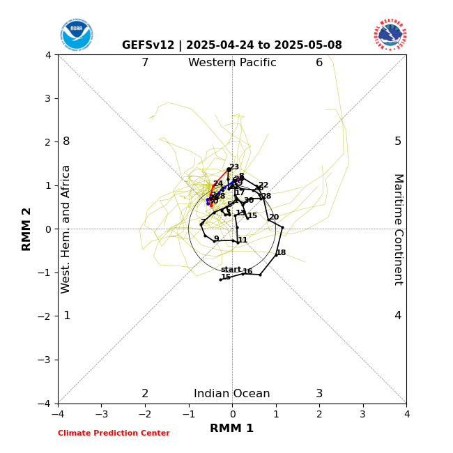
From today's weekly MJO update:

Image

In particular:

The MJO may contribute to continued broad suppression across the Western Hemisphere especially during week-2, reducing the chances for continued early season tropical cyclone (TC) activity across the Atlantic basin. Extremely warm SSTs present a significant reservoir for additional activity, however, should shear weaken in the vicinity of any disturbance or easterly wave.
0 likes   

User avatar
chaser1
S2K Supporter
S2K Supporter
Posts: 5464
Age: 64
Joined: Sat Oct 15, 2005 5:59 pm
Location: Longwood, Fl

Re: 2024 Indicators: SST's, MSLP, Shear, SAL, Steering, Instability (Day 16+ Climate Models)

#1534 Postby chaser1 » Mon Jul 15, 2024 4:25 pm

:uarrow: For the sake of clarification, I'm assuming that the reference to "week 2" suggests the 2nd week out from the (July 15th) forecast date, correct (as opposed to the 2nd week of July which has now passed)? That said, my gut sense leans toward a "EURO centric" solution and a notable convective surge emanating from a hardly discernable TW in the south/central Caribbean around the 25th of this month, followed by some level of cyclogenesis in the W. Caribbean. We've seen years where a significantly coherent MJO signal across the Atlantic basin seems prerequisite for tropical development given the otherwise lack of atmospheric instability. 2023 taught me that anomalous SST's seem to counter otherwise neutral to slightly unfavorable atmospheric conditions. I trust the EURO with regard to picking up on larger scale signals and assume there will be some lower latitude "sweet spot" that is not enveloped by SAL conditions.
1 likes   
Andy D

(For official information, please refer to the NHC and NWS products.)

User avatar
ScottNAtlanta
Category 5
Category 5
Posts: 2367
Joined: Sat May 25, 2013 3:11 pm
Location: Atlanta, GA

Re: 2024 Indicators: SST's, MSLP, Shear, SAL, Steering, Instability (Day 16+ Climate Models)

#1535 Postby ScottNAtlanta » Mon Jul 15, 2024 11:20 pm

0 likes   
The posts in this forum are NOT official forecast and should not be used as such. They are just the opinion of the poster and may or may not be backed by sound meteorological data. They are NOT endorsed by any professional institution or storm2k.org. For official information, please refer to the NHC and NWS products.

User avatar
chaser1
S2K Supporter
S2K Supporter
Posts: 5464
Age: 64
Joined: Sat Oct 15, 2005 5:59 pm
Location: Longwood, Fl

Re: 2024 Indicators: SST's, MSLP, Shear, SAL, Steering, Instability (Day 16+ Climate Models)

#1536 Postby chaser1 » Tue Jul 16, 2024 12:20 am

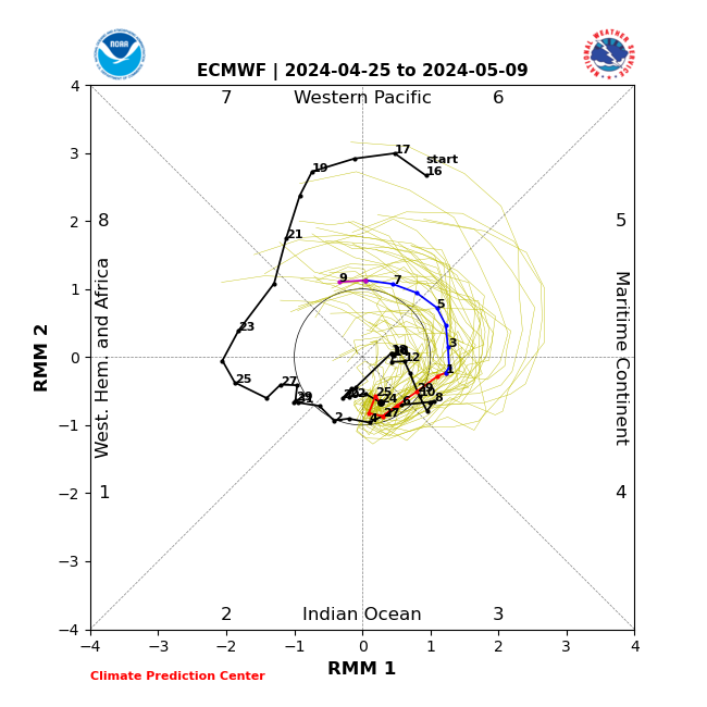
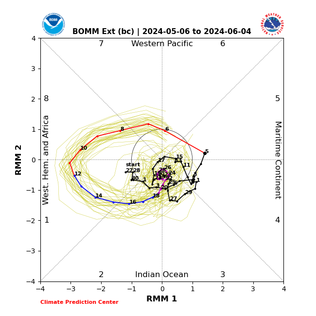
Odd, the EURO does not depict any more of a coherent MJO signal, contrary to the discussion as posted. In fact, it is the Australian model that depicts a far more clear MJO signal suggesting a possible uptick for the W. Hemisphere and Atlantic. I find that suspicious however in light of a entirely muted MJO signal by the GEFS and Euro.
0 likes   
Andy D

(For official information, please refer to the NHC and NWS products.)

User avatar
Nimbus
Category 5
Category 5
Posts: 5300
Joined: Mon Jul 19, 2004 10:54 am

Re: 2024 Indicators: SST's, MSLP, Shear, SAL, Steering, Instability (Day 16+ Climate Models)

#1537 Postby Nimbus » Tue Jul 16, 2024 6:17 am

WaveBreaking wrote:Very active wave over Africa right now, but what really catches my attention is how noticeable and pronounced the upper-level ridge over it is.


https://imgur.com/KLht6gR.gif https://i.imgur.com/VIo105L.png

None of the models develop it as they all show it getting overwhelmed by the SAL outbreak ahead of it.


The sharpening wave near 9.5N -35.7W looked stronger coming off Africa but the dry air has kept it from spinning up.
0 likes   

zzzh
Category 3
Category 3
Posts: 834
Joined: Thu Sep 02, 2021 1:13 pm

Re: 2024 Indicators: SST's, MSLP, Shear, SAL, Steering, Instability (Day 16+ Climate Models)

#1538 Postby zzzh » Tue Jul 16, 2024 8:09 am

Image
VP200 looks very favorable for the Atlantic, but 200mb wind and SLP looks like there is a subsidence branch over Atl.
1 likes   

User avatar
Steve
S2K Supporter
S2K Supporter
Posts: 9621
Joined: Sat Apr 05, 2003 11:41 pm
Location: Not a state-caster

Re: 2024 Indicators: SST's, MSLP, Shear, SAL, Steering, Instability (Day 16+ Climate Models)

#1539 Postby Steve » Tue Jul 16, 2024 8:13 am

chaser1 wrote:Odd, the EURO does not depict any more of a coherent MJO signal, contrary to the discussion as posted. In fact, it is the Australian model that depicts a far more clear MJO signal suggesting a possible uptick for the W. Hemisphere and Atlantic. I find that suspicious however in light of a entirely muted MJO signal by the GEFS and Euro.


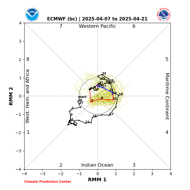
BOMM (Australian bias-corrected) often does better sniffing out pulses of MJO. When it and the JMA agree, they usually get it right. However both the ECMF and ECMM (bias corrected) show a hook through the WPAC (phases 6 and 7) and down toward phases 8 and 1.

ECMF
Image

ECMM (bias-corrected)
Image
0 likes   

User avatar
cycloneye
Admin
Admin
Posts: 145303
Age: 68
Joined: Thu Oct 10, 2002 10:54 am
Location: San Juan, Puerto Rico

Re: 2024 Indicators: SST's, MSLP, Shear, SAL, Steering, Instability (Day 16+ Climate Models)

#1540 Postby cycloneye » Tue Jul 16, 2024 8:40 am

1 likes   
Visit the Caribbean-Central America Weather Thread where you can find at first post web cams,radars
and observations from Caribbean basin members Click Here


Return to “Talkin' Tropics”

Who is online

Users browsing this forum: IsabelaWeather, riapal and 44 guests