Texas Summer 2024

U.S. & Caribbean Weather Discussions and Severe Weather Events

Moderator: S2k Moderators

Forum rules

The posts in this forum are NOT official forecast and should not be used as such. They are just the opinion of the poster and may or may not be backed by sound meteorological data. They are NOT endorsed by any professional institution or STORM2K.

Help Support Storm2K
Message
Author
weatherdude1108
Category 5
Category 5
Posts: 4228
Joined: Tue Dec 13, 2011 1:04 pm
Location: Northwest Austin/Cedar Park, TX

Re: Texas Summer 2024

#501 Postby weatherdude1108 » Tue Jul 23, 2024 4:25 pm

Stratton23 wrote:The core of the heat in regards to the ridge rebuilding back in again should be mainly focused over the northern us and highplains, with mainly mid -upper 90’s for texas, i think texas lucks out again


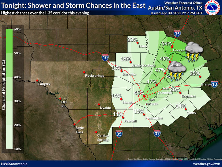
NOT complaining here at all after the previous couple of Summers we've had. I had to screenshot this graphic this morning from EWX, just on its rarity this time of year. Such a site for sore eyes.

Cherishing the moment, that even in July, it is possible to have Spring and Fall weather! :)
:rain: :lightning: :rain:

Image
3 likes   
The preceding post is NOT an official forecast, and should not be used as such. It is only the opinion of the poster and may or may not be backed by sound meteorological data. It is NOT endorsed by any professional institution including storm2k.org. For Official Information please refer to the NHC and NWS products.

User avatar
jasons2k
Storm2k Executive
Storm2k Executive
Posts: 8245
Age: 51
Joined: Wed Jul 06, 2005 12:32 pm
Location: The Woodlands, TX

Re: Texas Summer 2024

#502 Postby jasons2k » Tue Jul 23, 2024 4:56 pm

From Jeff Lindner:

Flood Watch issued for much of SE TX until Wednesday evening.

Combination of increasing Gulf moisture, lift from an upper level trough over the region, and slow/training storm motions will produce a threat for heavy to excessive rainfall early this evening and then again late tonight into Wednesday.

Heavy rainfall is currently ongoing over portions of Montgomery County with scattered to numerous showers and thunderstorms developing over much of the area west of I-45 and north of I-10. Ongoing activity should begin to weaken and dissipate by mid evening with the loss of heating, but rainfall amounts over the next 3-5 hours of 2-4 inches in an hour or less will be possible with the heavier storms.

Late tonight into Wednesday the trough axis and lift will slowly sag southward toward the I-10 corridor and this combined with low level speed convergence near the coast late tonight will result in the development of thunderstorms that slowly progress inland. These storms will have the potential to produce rainfall rates of 3-5 inches per hour which is raising the flash flood risk for early Wednesday along and south of the I-10 corridor. It is possible that much of this activity could remain near the coast or just offshore, but it is close enough to warrant a close watch.

Additional rainfall amounts of 2-4 inches can be expected over much of the area with amounts of 4-6 inches south of I-10. Would not be surprised to see an isolated 10 inch amount somewhere given the air mass in place and the amounts that have happened in central and SW TX today. Some of these higher amounts are also supported on the recent HREF guidance, especially near the coast.

Flash flooding will be possible under the heavy rain cores as well as quick rises on area creeks and bayous.

East Fork of the San Jacinto River:
Heavy rainfall yesterday and again today will produce a significant rise along the river from above Cleveland to Lake Houston starting on Wednesday and lasting into late this week. The river will rise above flood stage late Wednesday at FM 1485 and above moderate flood levels on Thursday. Low lying roads near the river will be impacted and FM 1485 will potentially be overtopped. The current forecast for the river is well below levels experienced in May of this year.

Image

Jeff Lindner
Director Hydrologic Operations Division/Meteorologist
Harris County Flood Control District
9900 Northwest Freeway | Houston, Texas 77092
346-286-4000 (main) | 346-286-4165 (direct) | 281-924-2091 (cell)
jeff.lindner@hcfcd.org | Twitter: @jefflindner1
1 likes   

User avatar
Edwards Limestone
S2K Supporter
S2K Supporter
Posts: 476
Age: 36
Joined: Tue Dec 28, 2021 11:05 am
Location: Smithson Valley, TX

Re: Texas Summer 2024

#503 Postby Edwards Limestone » Tue Jul 23, 2024 5:05 pm

weatherdude1108 wrote:
Stratton23 wrote:The core of the heat in regards to the ridge rebuilding back in again should be mainly focused over the northern us and highplains, with mainly mid -upper 90’s for texas, i think texas lucks out again


NOT complaining here at all after the previous couple of Summers we've had. I had to screenshot this graphic this morning from EWX, just on its rarity this time of year. Such a site for sore eyes.

Cherishing the moment, that even in July, it is possible to have Spring and Fall weather! :)
:rain: :lightning: :rain:

https://www.weather.gov/images/ewx/graphicast/small4.png


:notworthy: :notworthy: :notworthy: :Touchdown:
3 likes   
The above post is NOT an official forecast and should not be used as such. It is just the opinion of the poster and may or may not be backed by sound meteorological data. It is NOT endorsed by any professional institution including Storm2k. For official information, please refer to NWS products.

utpmg
S2K Supporter
S2K Supporter
Posts: 230
Age: 66
Joined: Thu Jan 03, 2013 12:07 am
Location: East Austin

Re: Texas Summer 2024

#504 Postby utpmg » Wed Jul 24, 2024 6:16 am

from LCRA this morning:
Lake level forecast: Lake Travis is expected rise to a range of 638-640 ft msl over the next 24 hours.

It is about 635 right now, was 634 last week, so while this is not a drought-buster (so far) as someone above aptly remarked it's certainly a "drought-denter."
1 likes   

weatherdude1108
Category 5
Category 5
Posts: 4228
Joined: Tue Dec 13, 2011 1:04 pm
Location: Northwest Austin/Cedar Park, TX

Re: Texas Summer 2024

#505 Postby weatherdude1108 » Wed Jul 24, 2024 8:17 am

I like looking at this. It's a real-time look at what's going on in the LCRA dam chain. You can switch between rainfall, stream flow, river stage, lake levels, etc. You can access the report links through here also.

https://hydromet.lcra.org/#
1 likes   
The preceding post is NOT an official forecast, and should not be used as such. It is only the opinion of the poster and may or may not be backed by sound meteorological data. It is NOT endorsed by any professional institution including storm2k.org. For Official Information please refer to the NHC and NWS products.

utpmg
S2K Supporter
S2K Supporter
Posts: 230
Age: 66
Joined: Thu Jan 03, 2013 12:07 am
Location: East Austin

Re: Texas Summer 2024

#506 Postby utpmg » Wed Jul 24, 2024 8:26 am

weatherdude1108 wrote:I like looking at this. It's a real-time look at what's going on in the LCRA dam chain. You can switch between rainfall, stream flow, river stage, lake levels, etc. You can access the report links through here also.

https://hydromet.lcra.org/#

Yep, been using that for years, but it doesn't work well at all on my iPhone
0 likes   

weatherdude1108
Category 5
Category 5
Posts: 4228
Joined: Tue Dec 13, 2011 1:04 pm
Location: Northwest Austin/Cedar Park, TX

Re: Texas Summer 2024

#507 Postby weatherdude1108 » Wed Jul 24, 2024 8:57 am

utpmg wrote:
weatherdude1108 wrote:I like looking at this. It's a real-time look at what's going on in the LCRA dam chain. You can switch between rainfall, stream flow, river stage, lake levels, etc. You can access the report links through here also.

https://hydromet.lcra.org/#

Yep, been using that for years, but it doesn't work well at all on my iPhone


Yeah, I've noticed it cuts off the right part of the screen on my android sometimes. Laptop/desktop works better.
0 likes   
The preceding post is NOT an official forecast, and should not be used as such. It is only the opinion of the poster and may or may not be backed by sound meteorological data. It is NOT endorsed by any professional institution including storm2k.org. For Official Information please refer to the NHC and NWS products.

Stratton23
Category 5
Category 5
Posts: 2518
Joined: Fri Jul 21, 2023 10:59 pm
Location: Katy, Tx

Re: Texas Summer 2024

#508 Postby Stratton23 » Wed Jul 24, 2024 11:01 am

Glad the hill country got good rains, but main this was such an over hyped and complete bust of a wet pattern here in se texas, everything has been at the coast, barely managed to get an inch here the past few days , big time bust
0 likes   

User avatar
Cpv17
Category 5
Category 5
Posts: 4975
Joined: Wed Dec 07, 2016 2:24 pm
Location: Wharton/El Campo, TX

Re: Texas Summer 2024

#509 Postby Cpv17 » Wed Jul 24, 2024 12:20 pm

Stratton23 wrote:Glad the hill country got good rains, but main this was such an over hyped and complete bust of a wet pattern here in se texas, everything has been at the coast, barely managed to get an inch here the past few days , big time bust


I’ve had about .05”. A couple of light showers for a couple minutes, that’s about it. Total bust.
0 likes   

User avatar
South Texas Storms
Professional-Met
Professional-Met
Posts: 4224
Joined: Thu Jun 24, 2010 12:28 am
Location: Houston, TX

Re: Texas Summer 2024

#510 Postby South Texas Storms » Wed Jul 24, 2024 1:56 pm

Cpv17 wrote:
Stratton23 wrote:Glad the hill country got good rains, but main this was such an over hyped and complete bust of a wet pattern here in se texas, everything has been at the coast, barely managed to get an inch here the past few days , big time bust


I’ve had about .05”. A couple of light showers for a couple minutes, that’s about it. Total bust.


The heaviest rain for southeast TX will likely arrive tomorrow. Some areas could pick up 4-6 inches.
0 likes   

weatherdude1108
Category 5
Category 5
Posts: 4228
Joined: Tue Dec 13, 2011 1:04 pm
Location: Northwest Austin/Cedar Park, TX

Re: Texas Summer 2024

#511 Postby weatherdude1108 » Wed Jul 24, 2024 3:30 pm

Well, our chances of precip have gone way down since yesterday, 20 to 40% (at the highest now) through Sunday. :roll:

Back to the grind.
0 likes   
The preceding post is NOT an official forecast, and should not be used as such. It is only the opinion of the poster and may or may not be backed by sound meteorological data. It is NOT endorsed by any professional institution including storm2k.org. For Official Information please refer to the NHC and NWS products.

Stratton23
Category 5
Category 5
Posts: 2518
Joined: Fri Jul 21, 2023 10:59 pm
Location: Katy, Tx

Re: Texas Summer 2024

#512 Postby Stratton23 » Wed Jul 24, 2024 5:57 pm

It looks like whatever dry/hot period after this looks to be short lived as the heat ridge looks to be transient and not park directly over texas, it actually looks to build and really amplify over the western and northern US, GFS / and Euro already showing another backdoor trough coming down into the central plains after ridging passes us by with a few hot/ dry days, overall texas should escape a prolonged heat wave yet again
3 likes   

User avatar
Ntxw
Storm2k Moderator
Storm2k Moderator
Posts: 22784
Joined: Wed Oct 21, 2009 6:34 pm
Location: DFW, Texas

Re: Texas Summer 2024

#513 Postby Ntxw » Wed Jul 24, 2024 7:55 pm

Stratton23 wrote:It looks like whatever dry/hot period after this looks to be short lived as the heat ridge looks to be transient and not park directly over texas, it actually looks to build and really amplify over the western and northern US, GFS / and Euro already showing another backdoor trough coming down into the central plains after ridging passes us by with a few hot/ dry days, overall texas should escape a prolonged heat wave yet again


This is what I'm interpreting from guidance as well. We will heat up (around 100 which isn't wildly crazy) when new ridge forms but it will quickly migrate to the Rockies and we will likely be in another area of weakness. No core ridge staying power this summer for TX.
3 likes   
The above post and any post by Ntxw is NOT an official forecast and should not be used as such. It is just the opinion of the poster and may or may not be backed by sound meteorological data. It is NOT endorsed by any professional institution including Storm2k. For official information, please refer to NWS products.

  Help support Storm2K!
Help Support Storm2K

User avatar
South Texas Storms
Professional-Met
Professional-Met
Posts: 4224
Joined: Thu Jun 24, 2010 12:28 am
Location: Houston, TX

Re: Texas Summer 2024

#514 Postby South Texas Storms » Wed Jul 24, 2024 8:05 pm

Ntxw wrote:
Stratton23 wrote:It looks like whatever dry/hot period after this looks to be short lived as the heat ridge looks to be transient and not park directly over texas, it actually looks to build and really amplify over the western and northern US, GFS / and Euro already showing another backdoor trough coming down into the central plains after ridging passes us by with a few hot/ dry days, overall texas should escape a prolonged heat wave yet again


This is what I'm interpreting from guidance as well. We will heat up (around 100 which isn't wildly crazy) when new ridge forms but it will quickly migrate to the Rockies and we will likely be in another area of weakness. No core ridge staying power this summer for TX.


The only bad thing about that is it opens up the TX coast to another tropical threat. The last thing Houston needs is another hurricane this year. Otherwise this summer has been great weather-wise around here.
2 likes   

User avatar
South Texas Storms
Professional-Met
Professional-Met
Posts: 4224
Joined: Thu Jun 24, 2010 12:28 am
Location: Houston, TX

Re: Texas Summer 2024

#515 Postby South Texas Storms » Fri Jul 26, 2024 12:21 am

Rained steadily most of the day in Houston today with a high temp in the 70s! Now that's what I call nice summer weather.
3 likes   

weatherdude1108
Category 5
Category 5
Posts: 4228
Joined: Tue Dec 13, 2011 1:04 pm
Location: Northwest Austin/Cedar Park, TX

Re: Texas Summer 2024

#516 Postby weatherdude1108 » Fri Jul 26, 2024 8:49 am

Local tv met Avery Tomasco said that he was doing the math, and said 22 BILLION gallons of water has been added to Lake Travis over the last several days!

He said someone on Twitter (now X) asked him how many cans of Dr. Pepper that is. He said in doing the math, he got 237 BILLION cans of Dr. Pepper. :lol:


Following floodgate operations at Wirtz and Starcke dams (which have now concluded), Lake Travis now sits 6 feet higher than one week ago and is closing in on 641 feet above sea level. The bad news is that we need another 40 FEET to get back to full elevation, but the good news is that rising lake levels of any variety are extremely rare in July.

This is a significant amount of water regardless. 6 feet of elevation gain translates to more than 20 billion gallons of water added to our water supply which is now at its healthiest since December 2022. A long way still to go, but a fantastic start.

Despite the closure of the floodgates upstream, there is still quite a bit of water flowing through those dams in the form of hydroelectric power generation. That will continue to add water to Lake Travis over the weekend, albeit at a slower rate. Another 1-2 feet of elevation gain is possible when all is said and done.


https://cbsaustin.com/weather
2 likes   
The preceding post is NOT an official forecast, and should not be used as such. It is only the opinion of the poster and may or may not be backed by sound meteorological data. It is NOT endorsed by any professional institution including storm2k.org. For Official Information please refer to the NHC and NWS products.

utpmg
S2K Supporter
S2K Supporter
Posts: 230
Age: 66
Joined: Thu Jan 03, 2013 12:07 am
Location: East Austin

Re: Texas Summer 2024

#517 Postby utpmg » Fri Jul 26, 2024 12:00 pm

weatherdude1108 wrote:Local tv met Avery Tomasco said that he was doing the math, and said 22 BILLION gallons of water has been added to Lake Travis over the last several days!

He said someone on Twitter (now X) asked him how many cans of Dr. Pepper that is. He said in doing the math, he got 237 BILLION cans of Dr. Pepper. :lol:


And it's still not even half full.
2 likes   

Stratton23
Category 5
Category 5
Posts: 2518
Joined: Fri Jul 21, 2023 10:59 pm
Location: Katy, Tx

Re: Texas Summer 2024

#518 Postby Stratton23 » Fri Jul 26, 2024 2:25 pm

Noaa 6-10 and 8-14 day outlooks still favor above normal odds of precipitation for most of texas, whatever drying period happens after sunday looks to be pretty short lived
4 likes   

User avatar
Edwards Limestone
S2K Supporter
S2K Supporter
Posts: 476
Age: 36
Joined: Tue Dec 28, 2021 11:05 am
Location: Smithson Valley, TX

Re: Texas Summer 2024

#519 Postby Edwards Limestone » Fri Jul 26, 2024 3:28 pm

Stratton23 wrote:Noaa 6-10 and 8-14 day outlooks still favor above normal odds of precipitation for most of texas, whatever drying period happens after sunday looks to be pretty short lived


Awesome news, let's keep it going for the rest of the summer.
Need moar rain down here plz. Canyon Lake still only up 2' with all this rain.
Image
2 likes   
The above post is NOT an official forecast and should not be used as such. It is just the opinion of the poster and may or may not be backed by sound meteorological data. It is NOT endorsed by any professional institution including Storm2k. For official information, please refer to NWS products.

weatherdude1108
Category 5
Category 5
Posts: 4228
Joined: Tue Dec 13, 2011 1:04 pm
Location: Northwest Austin/Cedar Park, TX

Re: Texas Summer 2024

#520 Postby weatherdude1108 » Fri Jul 26, 2024 4:09 pm

utpmg wrote:
weatherdude1108 wrote:Local tv met Avery Tomasco said that he was doing the math, and said 22 BILLION gallons of water has been added to Lake Travis over the last several days!

He said someone on Twitter (now X) asked him how many cans of Dr. Pepper that is. He said in doing the math, he got 237 BILLION cans of Dr. Pepper. :lol:


And it's still not even half full.


Yeah, I think the main problem is that, until this past event and back in the Fall for a bit, the rains have been falling mostly downstream of where they need to fall, and when they do fall in the right places, the dry soils soak it in before it can run off into watersheds. Then it doesn't rain for a month, and the cycle starts over when it rains on dry soils again, rinse, repeat...then the rumors of the property owners building dams diverting creeks and rivers into their stock tanks, etc., that would otherwise flow into the lakes. :roll:

What needs to happen is we need to get heavy rain events in the right places a couple times a week. But that's unrealistic.

Then there are those ocasional rain bombs that park over an area upstream, dumping 18 inches of rain in 6 hours, filling up a low lake overnight, like what happened in 2007. I remember that. Crazy!

https://cbsaustin.com/news/local/marble ... ne-27-2007
chrome-extension://efaidnbmnnnibpcajpcglclefindmkaj/https://hydromet.lcra.org/Documents/2007_flood_report.pdf
1 likes   
The preceding post is NOT an official forecast, and should not be used as such. It is only the opinion of the poster and may or may not be backed by sound meteorological data. It is NOT endorsed by any professional institution including storm2k.org. For Official Information please refer to the NHC and NWS products.


Return to “USA & Caribbean Weather”

Who is online

Users browsing this forum: cycloneye and 17 guests