Possible development in the Western Atlantic / GOM (Is Invest 97L)
Moderator: S2k Moderators
Forum rules

The posts in this forum are NOT official forecasts and should not be used as such. They are just the opinion of the poster and may or may not be backed by sound meteorological data. They are NOT endorsed by any professional institution or STORM2K. For official information, please refer to products from the National Hurricane Center and National Weather Service.
-
Stratton23
- Category 5

- Posts: 3574
- Joined: Fri Jul 21, 2023 10:59 pm
- Location: Katy, Tx
Re: Possible development in the central Atlantic
Steering pattern on the GFS and CMC is scary, that kind of pattern would lead to someone on the gulf coast getting walloped
0 likes

Re: Possible development in the central Atlantic
0z GFS does not string the wave out, but it does take the path of most resistance. Crosses directly over Hispaniola and down the spine of Cuba, and enters the Gulf as an open wave as a result. It still manages to become a hurricane by landfall.

0 likes
Kendall -> SLO -> PBC
Memorable Storms: Katrina (for its Florida landfall...) Wilma Matthew Irma
Memorable Storms: Katrina (for its Florida landfall...) Wilma Matthew Irma
Re: Possible development in the central Atlantic
0Z Euro: TD forms Bahamas forms 8/2. Becomes H and recurves a bit E of NC. Let’s see what EPS says.
1 likes
Personal Forecast Disclaimer:
The posts in this forum are NOT official forecasts and should not be used as such. They are just the opinion of the poster and may or may not be backed by sound meteorological data. They are NOT endorsed by any professional institution or storm2k.org. For official information, please refer to the NHC and NWS products.
The posts in this forum are NOT official forecasts and should not be used as such. They are just the opinion of the poster and may or may not be backed by sound meteorological data. They are NOT endorsed by any professional institution or storm2k.org. For official information, please refer to the NHC and NWS products.
-
Stratton23
- Category 5
- Posts: 3574
- Joined: Fri Jul 21, 2023 10:59 pm
- Location: Katy, Tx
Re: Possible development in the central Atlantic
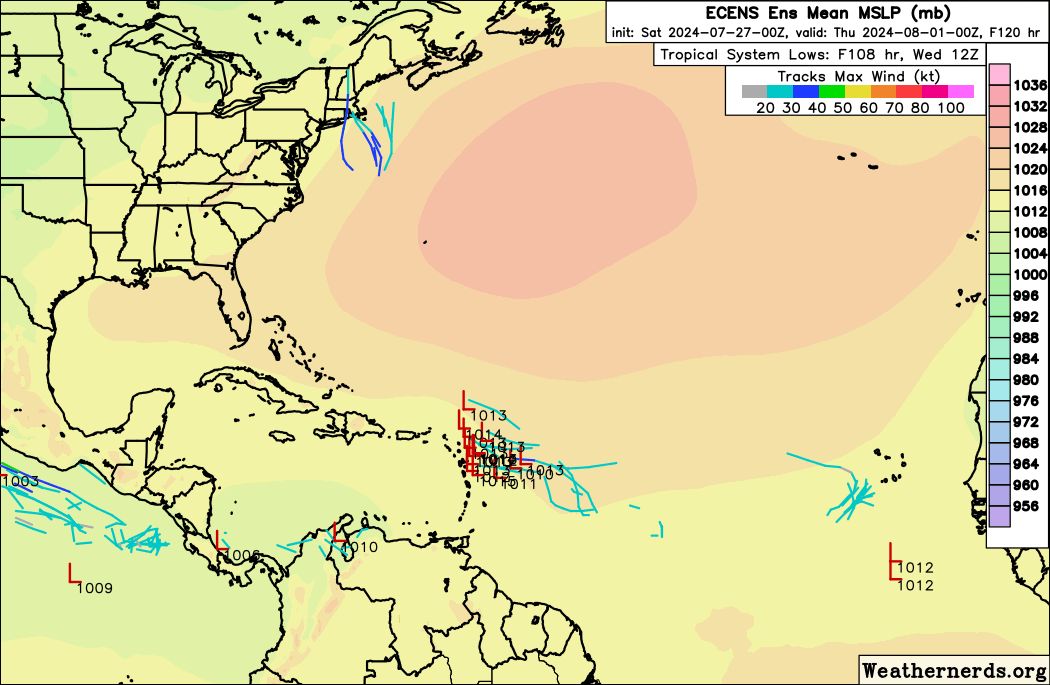
00z EPS is more aggressive , spread from s. texas to up the se us coast line
0 likes

Re: Possible development in the central Atlantic
LarryWx wrote:0Z Euro: TD forms Bahamas forms 8/2. Becomes H and recurves a bit E of NC. Let’s see what EPS says.
florida forcefield arrives just in time to recurve, lets see if it holds......
0 likes

-
Category5Kaiju

- Category 5
- Posts: 4345
- Joined: Thu Dec 24, 2020 12:45 pm
- Location: Seattle during the summer, Phoenix during the winter
Re: Possible development in the central Atlantic
CMC has the system now too (takes a Laura-like track). Funny enough, that recent ECMWF operational seems to be very anomalous as other models, assuming they do show this system, have it entering the Gulf
0 likes
Unless explicitly stated, all information in my posts is based on my own opinions and observations. Tropical storms and hurricanes can be extremely dangerous. Refer to an accredited weather research agency or meteorologist if you need to make serious decisions regarding an approaching storm.
-
AtlanticWind

- S2K Supporter

- Posts: 1898
- Age: 67
- Joined: Sun Aug 08, 2004 9:57 pm
- Location: Plantation,Fla
-
SFLcane

- S2K Supporter
- Posts: 10281
- Age: 48
- Joined: Sat Jun 05, 2010 1:44 pm
- Location: Lake Worth Florida
Re: Possible development in the central Atlantic
AtlanticWind wrote:Wow ,the euro ensembles really active now
0 likes
-
USTropics
- Professional-Met

- Posts: 2739
- Joined: Sun Aug 12, 2007 3:45 am
- Location: Florida State University
Re: Possible development in the central Atlantic
This is an interesting evolution to watch over the next 5 days. Here is an analysis I put together this morning showing our 3 current active TWS (pink, blue, green). I've outlined the monsoonal trough/ITCZ in red and the deep layer SAL in yellow (with the lesser extension outlined in dashed yellow):

Another great tool to analyze these tropical waves is Earthnull (https://earth.nullschool.net/#current/w ... 20.62,1351). Here I'm using 700mb wind flow to identify the wind field kinks with RH shaded:

Switching over to the models for the next 5 days, the ECMWF has been the most consistent with the evolution so far. This is the 00z run, and I've again outlined the three active tropical waves. I've also indicated the projected paths of their moisture plumes (which is where things get interesting). It appears the northern axis of TW3 (green) becomes fractured, and pivots around TW2 (blue) which causes TW2 to slow down as it interacts with a feature embedded in the ITCZ. The trough axis from TW3 that fractures becomes collocated to the north in ~4 days, and the moisture field from TW2 is streamlined north as TW3 passes near the Leeward Islands/Puerto Rico:

The full 5-day animation:

The 700mb vorticity product also furth shows TW3 is the main catalyst here:

The GFS has been playing a bit of catch up with this evolution. The last few runs are now showing a more pronounced moisture signature (like the ECMWF runs). Here is a trend of the last 6 GFS runs as the system approached Puerto Rico:

Another great tool to analyze these tropical waves is Earthnull (https://earth.nullschool.net/#current/w ... 20.62,1351). Here I'm using 700mb wind flow to identify the wind field kinks with RH shaded:
Switching over to the models for the next 5 days, the ECMWF has been the most consistent with the evolution so far. This is the 00z run, and I've again outlined the three active tropical waves. I've also indicated the projected paths of their moisture plumes (which is where things get interesting). It appears the northern axis of TW3 (green) becomes fractured, and pivots around TW2 (blue) which causes TW2 to slow down as it interacts with a feature embedded in the ITCZ. The trough axis from TW3 that fractures becomes collocated to the north in ~4 days, and the moisture field from TW2 is streamlined north as TW3 passes near the Leeward Islands/Puerto Rico:
The full 5-day animation:
The 700mb vorticity product also furth shows TW3 is the main catalyst here:
The GFS has been playing a bit of catch up with this evolution. The last few runs are now showing a more pronounced moisture signature (like the ECMWF runs). Here is a trend of the last 6 GFS runs as the system approached Puerto Rico:
8 likes

Re: Possible development in the central Atlantic
USTropics wrote:This is an interesting evolution to watch over the next 5 days. Here is an analysis I put together this morning showing our 3 current active TWS (pink, blue, green). I've outlined the monsoonal trough/ITCZ in red and the deep layer SAL in yellow (with the lesser extension outlined in dashed yellow):
https://i.imgur.com/NzmOQbM.png
Another great tool to analyze these tropical waves is Earthnull (https://earth.nullschool.net/#current/w ... 20.62,1351). Here I'm using 700mb wind flow to identify the wind field kinks with RH shaded:
https://i.imgur.com/hjDEa5v.png
Switching over to the models for the next 5 days, the ECMWF has been the most consistent with the evolution so far. This is the 00z run, and I've again outlined the three active tropical waves. I've also indicated the projected paths of their moisture plumes (which is where things get interesting). It appears the northern axis of TW3 (green) becomes fractured, and pivots around TW2 (blue) which causes TW2 to slow down as it interacts with a feature embedded in the ITCZ. The trough axis from TW2 that fractures becomes collocated to the north in ~4 days, and the moisture field from TW2 is streamlined north as TW3 passes near the Leeward Islands/Puerto Rico:
https://i.imgur.com/hrIG30Q.png
The full 5-day animation:
https://i.ibb.co/hyQr2wq/ecmwf-mid-RH-atl-fh0-120.gif
The 700mb vorticity product also furth shows TW3 is the main catalyst here:
https://i.ibb.co/f9FmCzT/ecmwf-z700-vort-atl-fh0-120.gif
The GFS has been playing a bit of catch up with this evolution. The last few runs are now showing a more pronounced moisture signature (like the ECMWF runs). Here is a trend of the last 6 GFS runs as the system approached Puerto Rico:
https://i.imgur.com/bX9AJSg.gif
NHC is holding off on an invest for the blue wave to see how much it dries out as it moves further west?
Tuesday is 72 hours out and the GFS ridge steering forecast has only migrated east a little with the 00z.
Everybody should be on the same page now thanks for the graphics!
0 likes
-
AtlanticWind
- S2K Supporter
- Posts: 1898
- Age: 67
- Joined: Sun Aug 08, 2004 9:57 pm
- Location: Plantation,Fla
Re: Possible development in the central Atlantic
Gfs with what looks like hurricane (984mb) near key west
0 likes
-
Keldeo1997
- Category 2

- Posts: 688
- Joined: Fri Oct 11, 2019 11:35 pm
Re: Possible development in the central Atlantic
06Z GFS is 1935 Labor day just not as strong
1 likes
-
cycloneye

- Admin

- Posts: 149696
- Age: 69
- Joined: Thu Oct 10, 2002 10:54 am
- Location: San Juan, Puerto Rico
Re: Possible development in the central Atlantic (0/30)
Tropical Weather Outlook
NWS National Hurricane Center Miami FL
800 AM EDT Sat Jul 27 2024
For the North Atlantic...Caribbean Sea and the Gulf of Mexico:
Near the Lesser and Greater Antilles:
An area of disturbed weather over the central tropical Atlantic
Ocean is expected to interact with an approaching tropical wave
during the next several days. Development of this system is possible
while it approaches the Lesser Antilles during the early to middle
part of next week and moves generally west-northwestward near or
over the Greater Antilles towards the latter part of next week.
* Formation chance through 48 hours...low...near 0 percent.
* Formation chance through 7 days...low...30 percent.
$$
Forecaster Berg

0 likes
Visit the Caribbean-Central America Weather Thread where you can find at first post web cams,radars
and observations from Caribbean basin members Click Here
and observations from Caribbean basin members Click Here
-
sphelps8681
- Category 2
- Posts: 785
- Joined: Thu Aug 16, 2007 5:37 pm
- Location: Somewhere over the rainbow
Re: Possible development in the central Atlantic
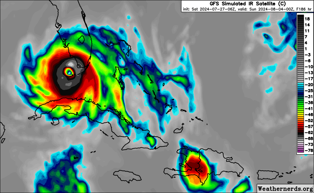
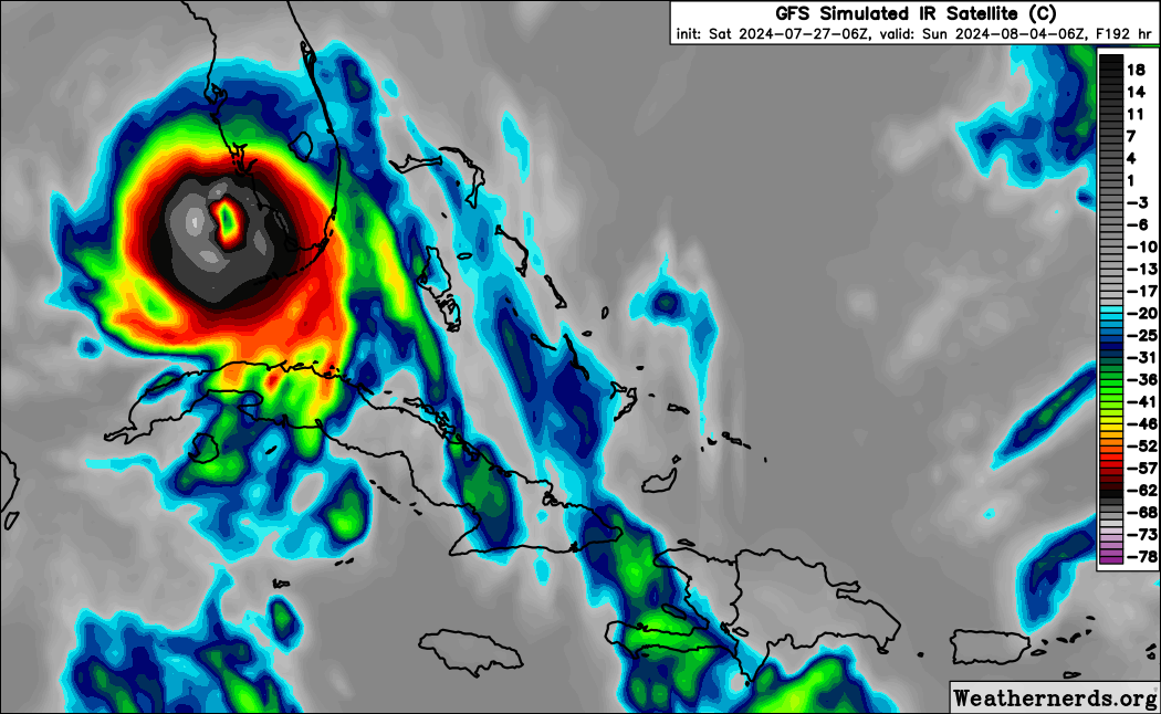
IcyTundra wrote:Looks like the GFS finally woke up.
https://i.ibb.co/kxPkQpV/gfs-mslp-pcpn-watl-fh120-264.gif
Well that is a bulleye straight at me. The day of landing is the first day of school for our area. Well still to far out so will keep an eye on this one. I am ready either way.
0 likes
-
REDHurricane

- Category 1

- Posts: 438
- Age: 28
- Joined: Sun Jul 03, 2022 2:36 pm
- Location: Northeast Pacific Ocean
2024 Global Model Runs Discussion (Out thru day 16)
00z is easily the most active EPS run yet and now GEFS/GEPS are starting to show a very faint, but still present, signal of development. Low shear, solid moisture pocket, healthy tropical disturbance, and above average SSTs all persist on the models. Things starting to get more interesting as we're now within the 7-10 day time frame where various models have demonstrated the ability to sniff out potential hurricanes somewhat effectively for the last few years at least.


0 likes
-
Hypercane_Kyle

- Category 5
- Posts: 3465
- Joined: Sat Mar 07, 2015 7:58 pm
- Location: Cape Canaveral, FL
Re: Possible development in the central Atlantic (0/30)
Much stronger model support this morning... GFS/Euro/CMC all show devleopment
0 likes
My posts are my own personal opinion, defer to the National Hurricane Center (NHC) and other NOAA products for decision making during hurricane season.
-
toad strangler

- S2K Supporter
- Posts: 4546
- Joined: Sun Jul 28, 2013 3:09 pm
- Location: Earth
- Contact:
-
toad strangler
- S2K Supporter
- Posts: 4546
- Joined: Sun Jul 28, 2013 3:09 pm
- Location: Earth
- Contact:
Who is online
Users browsing this forum: No registered users and 179 guests