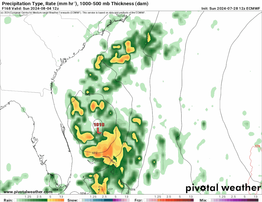
Just like is the case for the 12Z ICON, the 12Z UKMET is the first run with a TC from this (may be due to it just coming in range since TCG isn’t til the end of the run). It is in the NW Bahamas:
NEW TROPICAL CYCLONE FORECAST TO DEVELOP AFTER 168 HOURS
FORECAST POSITION AT T+168 : 25.0N 77.6W
LEAD CENTRAL MAXIMUM WIND
VERIFYING TIME TIME POSITION PRESSURE (MB) SPEED (KNOTS)
-------------- ---- -------- ------------- -------------
1200UTC 04.08.2024 168 25.0N 77.6W 1012 29
Possible development in the Western Atlantic / GOM (Is Invest 97L)
Moderator: S2k Moderators
Forum rules

The posts in this forum are NOT official forecasts and should not be used as such. They are just the opinion of the poster and may or may not be backed by sound meteorological data. They are NOT endorsed by any professional institution or STORM2K. For official information, please refer to products from the National Hurricane Center and National Weather Service.
Re: Possible development in the central Atlantic (0/40)
0 likes
Personal Forecast Disclaimer:
The posts in this forum are NOT official forecasts and should not be used as such. They are just the opinion of the poster and may or may not be backed by sound meteorological data. They are NOT endorsed by any professional institution or storm2k.org. For official information, please refer to the NHC and NWS products.
The posts in this forum are NOT official forecasts and should not be used as such. They are just the opinion of the poster and may or may not be backed by sound meteorological data. They are NOT endorsed by any professional institution or storm2k.org. For official information, please refer to the NHC and NWS products.
Re: Possible development in the central Atlantic (0/40)
Still coming in but 12z gfs has it in the Gulf again after several runs with nothing.


And then slows down/nearly stalls offshore of Panama City Beach, FL and gets in on Early Tuesday morning.

12z CMC also goes into gulf much like the 0z run.
And then slows down/nearly stalls offshore of Panama City Beach, FL and gets in on Early Tuesday morning.
12z CMC also goes into gulf much like the 0z run.
Last edited by BobHarlem on Sun Jul 28, 2024 11:34 am, edited 2 times in total.
0 likes
Re: Possible development in the central Atlantic (0/40)
BobHarlem wrote:Still coming in but 12z gfs has it in the Gulf again.
https://i.imgur.com/ZH452BU.png
https://i.imgur.com/Hirvi9Z.png
And then slows down/stalls offshore of Panama City Beach, FL.
https://i.imgur.com/zoDJ3Kh.png
The 12Z GFS is the first GFS with a TC from this since yesterday’s 6Z (hits the FL panhandle).
0 likes
Personal Forecast Disclaimer:
The posts in this forum are NOT official forecasts and should not be used as such. They are just the opinion of the poster and may or may not be backed by sound meteorological data. They are NOT endorsed by any professional institution or storm2k.org. For official information, please refer to the NHC and NWS products.
The posts in this forum are NOT official forecasts and should not be used as such. They are just the opinion of the poster and may or may not be backed by sound meteorological data. They are NOT endorsed by any professional institution or storm2k.org. For official information, please refer to the NHC and NWS products.
Re: Possible development in the central Atlantic (0/40)
LarryWx wrote:The 12Z ICON is its first run with a TC from this. At 180 it has a 1005 mb low moving NW in the direction of the central US GOM coast.
I like ICON. It seems to pick up on things some others don’t see.
Not crazy about this model run, tho!
1 likes
Cleo - 1964, Betsy - 1965, David - 1979, Andrew - 1992, Charlie (Francis, Ivan, Jeanne) - 2004, Irma - 2017, Ian - 2022, Milton - 2024
Re: Possible development in the central Atlantic (0/40)
12z CMC

12z gfs also makes landfall near Panama City Beach, but it moves very very slowly before landfall, almost stalls out.
12z gfs also makes landfall near Panama City Beach, but it moves very very slowly before landfall, almost stalls out.
Last edited by BobHarlem on Sun Jul 28, 2024 11:51 am, edited 1 time in total.
1 likes
-
Stratton23
- Category 5

- Posts: 3577
- Joined: Fri Jul 21, 2023 10:59 pm
- Location: Katy, Tx
Re: Possible development in the central Atlantic (0/40)
Things get interesting if this ends up in the gulf because as it approaches the NE gulf, the ridge may try to cut off its escape path north over land which could cause the system to temporarily stall out
0 likes
-
ThunderForce

- Tropical Storm

- Posts: 208
- Age: 26
- Joined: Tue Sep 27, 2022 6:20 pm
- Location: Calhoun County, Florida
Re: Possible development in the central Atlantic (0/40)
The Euro model and its ensembles appear to be the only ones consistently showcasing a more eastward/northeastward path.
1 likes
Please refer to the NWS, NHC, SPC or a professional meteorologist for information and decision making during storms.
-
SFLcane

- S2K Supporter

- Posts: 10281
- Age: 48
- Joined: Sat Jun 05, 2010 1:44 pm
- Location: Lake Worth Florida
Re: Possible development in the central Atlantic (0/40)
ECMWF might be a bit overamped now gfs,cmc,icon all more on a southern track. We shall see once a more coherent system forms if it ever does.
1 likes
Re: Possible development in the central Atlantic (0/40)
SFLcane wrote:ECMWF might be a bit overamped now gfs,cmc,icon all more on a southern track. We shall see once a more coherent system forms if it ever does.
Don’t forget the 12Z UKMET, which has it in the NW Bahamas recurving E of FL due to a 500 mb weakness (more like Euro). It is the only well followed 12Z with a TC not in the Gulf excluding the yet to be released Euro.
0 likes
Personal Forecast Disclaimer:
The posts in this forum are NOT official forecasts and should not be used as such. They are just the opinion of the poster and may or may not be backed by sound meteorological data. They are NOT endorsed by any professional institution or storm2k.org. For official information, please refer to the NHC and NWS products.
The posts in this forum are NOT official forecasts and should not be used as such. They are just the opinion of the poster and may or may not be backed by sound meteorological data. They are NOT endorsed by any professional institution or storm2k.org. For official information, please refer to the NHC and NWS products.
-
SFLcane
- S2K Supporter
- Posts: 10281
- Age: 48
- Joined: Sat Jun 05, 2010 1:44 pm
- Location: Lake Worth Florida
Re: Possible development in the central Atlantic (0/40)
LarryWx wrote:SFLcane wrote:ECMWF might be a bit overamped now gfs,cmc,icon all more on a southern track. We shall see once a more coherent system forms if it ever does.
Don’t forget the 12Z UKMET, which has it in the NW Bahamas recurving E of FL due to a 500 mb weakness (more like Euro). It is the only well followed 12Z with a TC not in the Gulf.
Maybe.. lets wait till something forms first.
1 likes
Re: Possible development in the central Atlantic (0/40)
The 12Z GEFS is less active than the most active to date 6Z GEFS, which had 5 TCs (all of which hit the CONUS). This run has 3 TCs, all of which either hit the E coast of FL or stay offshore the E coast. So, no Gulf TCs on the 12Z GEFS. The 6Z had one.
It is less active than the 6Z, but it is at least as active as any of the other GEFS runs to date. So, not a trend.
It is less active than the 6Z, but it is at least as active as any of the other GEFS runs to date. So, not a trend.
0 likes
Personal Forecast Disclaimer:
The posts in this forum are NOT official forecasts and should not be used as such. They are just the opinion of the poster and may or may not be backed by sound meteorological data. They are NOT endorsed by any professional institution or storm2k.org. For official information, please refer to the NHC and NWS products.
The posts in this forum are NOT official forecasts and should not be used as such. They are just the opinion of the poster and may or may not be backed by sound meteorological data. They are NOT endorsed by any professional institution or storm2k.org. For official information, please refer to the NHC and NWS products.
-
cycloneye

- Admin

- Posts: 149730
- Age: 69
- Joined: Thu Oct 10, 2002 10:54 am
- Location: San Juan, Puerto Rico
Re: Possible development in the central Atlantic (0/40)
Tropical Weather Outlook
NWS National Hurricane Center Miami FL
200 PM EDT Sun Jul 28 2024
For the North Atlantic...Caribbean Sea and the Gulf of Mexico:
Near the Leeward Islands and Greater Antilles:
An area of disturbed weather over the central tropical Atlantic
Ocean is expected to interact with an approaching tropical wave
during the next couple of days. Environmental conditions are
forecast to become conducive for some development thereafter, and
a tropical depression could form mid to late week while the system
is near or over the northern Leeward Islands, Greater Antilles, or
southwestern Atlantic Ocean.
* Formation chance through 48 hours...low...near 0 percent.
* Formation chance through 7 days...medium...40 percent.
$$
Forecaster Berg

0 likes
Visit the Caribbean-Central America Weather Thread where you can find at first post web cams,radars
and observations from Caribbean basin members Click Here
and observations from Caribbean basin members Click Here
Re: Possible development in the central Atlantic (0/40)
How about this change on the 12Z Euro?! It is much weaker (maybe a TD at most/1008 mb) that goes up the E seaboard from NC.
0 likes
Personal Forecast Disclaimer:
The posts in this forum are NOT official forecasts and should not be used as such. They are just the opinion of the poster and may or may not be backed by sound meteorological data. They are NOT endorsed by any professional institution or storm2k.org. For official information, please refer to the NHC and NWS products.
The posts in this forum are NOT official forecasts and should not be used as such. They are just the opinion of the poster and may or may not be backed by sound meteorological data. They are NOT endorsed by any professional institution or storm2k.org. For official information, please refer to the NHC and NWS products.
-
ThunderForce
- Tropical Storm
- Posts: 208
- Age: 26
- Joined: Tue Sep 27, 2022 6:20 pm
- Location: Calhoun County, Florida
Re: Possible development in the central Atlantic (0/40)
Why is the orange X way below the formation area on the NHC's chart?
0 likes
Please refer to the NWS, NHC, SPC or a professional meteorologist for information and decision making during storms.
-
Hypercane_Kyle

- Category 5
- Posts: 3465
- Joined: Sat Mar 07, 2015 7:58 pm
- Location: Cape Canaveral, FL
Re: Possible development in the central Atlantic (0/40)
LarryWx wrote:How about this change on the 12Z Euro?! It is much weaker (maybe a TD at most/1008 mb) that goes up the E seaboard from NC.
Where are you seeing the 12z Euro? Neither pivotalweather or tropicaltidbits have it out yet.
0 likes
My posts are my own personal opinion, defer to the National Hurricane Center (NHC) and other NOAA products for decision making during hurricane season.
Re: Possible development in the central Atlantic (0/40)
Hypercane_Kyle wrote:LarryWx wrote:How about this change on the 12Z Euro?! It is much weaker (maybe a TD at most/1008 mb) that goes up the E seaboard from NC.
Where are you seeing the 12z Euro? Neither pivotalweather or tropicaltidbits have it out yet.
Paid site
2 likes
Personal Forecast Disclaimer:
The posts in this forum are NOT official forecasts and should not be used as such. They are just the opinion of the poster and may or may not be backed by sound meteorological data. They are NOT endorsed by any professional institution or storm2k.org. For official information, please refer to the NHC and NWS products.
The posts in this forum are NOT official forecasts and should not be used as such. They are just the opinion of the poster and may or may not be backed by sound meteorological data. They are NOT endorsed by any professional institution or storm2k.org. For official information, please refer to the NHC and NWS products.
-
cycloneye
- Admin
- Posts: 149730
- Age: 69
- Joined: Thu Oct 10, 2002 10:54 am
- Location: San Juan, Puerto Rico
Re: Possible development in the central Atlantic (0/40)
1 likes
Visit the Caribbean-Central America Weather Thread where you can find at first post web cams,radars
and observations from Caribbean basin members Click Here
and observations from Caribbean basin members Click Here
-
SFLcane
- S2K Supporter
- Posts: 10281
- Age: 48
- Joined: Sat Jun 05, 2010 1:44 pm
- Location: Lake Worth Florida
Re: Possible development in the central Atlantic (0/40)
Hypercane_Kyle wrote:LarryWx wrote:How about this change on the 12Z Euro?! It is much weaker (maybe a TD at most/1008 mb) that goes up the E seaboard from NC.
Where are you seeing the 12z Euro? Neither pivotalweather or tropicaltidbits have it out yet.
1 likes
-
toad strangler

- S2K Supporter
- Posts: 4546
- Joined: Sun Jul 28, 2013 3:09 pm
- Location: Earth
- Contact:
Re: Possible development in the central Atlantic (0/40)
SFLcane wrote:Hypercane_Kyle wrote:LarryWx wrote:How about this change on the 12Z Euro?! It is much weaker (maybe a TD at most/1008 mb) that goes up the E seaboard from NC.
Where are you seeing the 12z Euro? Neither pivotalweather or tropicaltidbits have it out yet.
I'm assuming Storm Vista. It’s out on that service.
0 likes
My Weather Station
https://www.wunderground.com/dashboard/pws/KFLPORTS603
https://www.wunderground.com/dashboard/pws/KFLPORTS603
-
WaveBreaking

- Category 2

- Posts: 728
- Joined: Sun Jun 30, 2024 11:33 am
- Location: US
Re: Possible development in the central Atlantic (0/40)
ThunderForce wrote:Why is the orange X way below the formation area on the NHC's chart?
The current area marked by the NHC is forecast to merge with a large tropical wave off to the E. The resulting Fujiwhara interaction will pull the AOI to the NW before merging and moving WNW.


3 likes
I am NOT a professional meteorologist, so take all of my posts with a grain of salt. My opinions are mine and mine alone.
Who is online
Users browsing this forum: No registered users and 129 guests