
Possible development in the Western Atlantic / GOM (Is Invest 97L)
Moderator: S2k Moderators
Forum rules

The posts in this forum are NOT official forecasts and should not be used as such. They are just the opinion of the poster and may or may not be backed by sound meteorological data. They are NOT endorsed by any professional institution or STORM2K. For official information, please refer to products from the National Hurricane Center and National Weather Service.
-
tropicwatch

- Category 5

- Posts: 3426
- Age: 62
- Joined: Sat Jun 02, 2007 10:01 am
- Location: The Villages, Florida
- Contact:
Re: Possible development in the central Atlantic (0/50)
Whatever the 50% chance of development is based on. We might have a quick spin up situation. Right now there doesn't seem to be anything that would make it happen.
0 likes
Tropicwatch
Agnes 72', Eloise 75, Elena 85', Kate 85', Charley 86', Florence 88', Beryl 94', Dean 95', Erin 95', Opal 95', Earl 98', Georges 98', Ivan 2004', Arlene 2005', Dennis 2005', Ida 2009' Debby 2012' Irma 2017' Michael 2018'
Agnes 72', Eloise 75, Elena 85', Kate 85', Charley 86', Florence 88', Beryl 94', Dean 95', Erin 95', Opal 95', Earl 98', Georges 98', Ivan 2004', Arlene 2005', Dennis 2005', Ida 2009' Debby 2012' Irma 2017' Michael 2018'

Re: Possible development in the central Atlantic (0/50)
tropicwatch wrote:Whatever the 50% chance of development is based on. We might have a quick spin up situation. Right now there doesn't see to be anything that would make it happen. https://tropicwatch.info/GOES16-TAW-13-900x54007292024.gif
It's dry, but the juice is there.

2 likes
Kendall -> SLO -> PBC
Memorable Storms: Katrina (for its Florida landfall...) Wilma Matthew Irma
Memorable Storms: Katrina (for its Florida landfall...) Wilma Matthew Irma
-
Stratton23
- Category 5
- Posts: 3563
- Joined: Fri Jul 21, 2023 10:59 pm
- Location: Katy, Tx
Re: Possible development in the central Atlantic (0/50)
GFS wants to shunt the wave axis westward inland towards lousiana or extreme eastern texas , big differences in the 500 mb height pattern
1 likes
Re: Possible development in the central Atlantic (0/50)
For the 2nd 12z JMA in a row, it has what looks like a TD from near or just E of FL. It then moves NNE to 100-150 miles SE of the NC/SC border.
0 likes
Personal Forecast Disclaimer:
The posts in this forum are NOT official forecasts and should not be used as such. They are just the opinion of the poster and may or may not be backed by sound meteorological data. They are NOT endorsed by any professional institution or storm2k.org. For official information, please refer to the NHC and NWS products.
The posts in this forum are NOT official forecasts and should not be used as such. They are just the opinion of the poster and may or may not be backed by sound meteorological data. They are NOT endorsed by any professional institution or storm2k.org. For official information, please refer to the NHC and NWS products.
-
Category5Kaiju

- Category 5
- Posts: 4334
- Joined: Thu Dec 24, 2020 12:45 pm
- Location: Seattle and Phoenix
Re: Possible development in the central Atlantic (0/50)
Starting to think at this point we could see a Gert 2017-like storm, or at least one that takes a similar track
4 likes
Unless explicitly stated, all info in my posts is based on my own opinions and observations. Tropical storms and hurricanes can be extremely dangerous. Refer to an accredited weather research agency or meteorologist if you need to make serious decisions regarding an approaching storm.

-
MEANINGLESS_NUMBERS
- Category 2

- Posts: 503
- Joined: Mon Nov 02, 2020 1:43 pm
Re: Possible development in the central Atlantic (0/50)
GFS: nothing
Euro: 24 inches of rain in Charleston
Hmmm
Euro: 24 inches of rain in Charleston
Hmmm
1 likes
Emily '87, Felix '95, Gert '99, Fabian '03, Humberto '19, Paulette '20, Teddy '20, Fiona '22, Lee '23, Ernesto '24, Humberto/Imelda '25
-
skyline385

- Category 5
- Posts: 2728
- Age: 35
- Joined: Wed Aug 26, 2020 11:15 pm
- Location: Houston TX
Re: Possible development in the central Atlantic (0/50)
MEANINGLESS_NUMBERS wrote:GFS: nothing
Euro: 24 inches of rain in Charleston
Hmmm
You are comparing 18z GFS to 12z Euro, 12z GFS had the system stalled over Gulfport just like the Euro had it stalled over Charleston
1 likes
Re: Possible development in the central Atlantic (0/50)
The 12z GFS came within 20 miles of moving ashore before steering collapsed and allowed for brief development. As with the last two instances of the GFS dropping this system, development (with its solution) was riding on a razor's edge in the first place. There are no major synoptic or structural differences between the two runs in the mid term. The GFS remains alone in providing favorable upper-level winds south of the islands rather than north of them. If that does pan out, huge win for the GFS, but we will see.
0 likes
Kendall -> SLO -> PBC
Memorable Storms: Katrina (for its Florida landfall...) Wilma Matthew Irma
Memorable Storms: Katrina (for its Florida landfall...) Wilma Matthew Irma
Re: Possible development in the central Atlantic (0/50)
18z EPS has 75% of members developing. Most in the mid-grade TS camp, a few hurricanes all on the eastern end of guidance.

1 likes
Kendall -> SLO -> PBC
Memorable Storms: Katrina (for its Florida landfall...) Wilma Matthew Irma
Memorable Storms: Katrina (for its Florida landfall...) Wilma Matthew Irma
-
Blown Away

- S2K Supporter

- Posts: 10253
- Joined: Wed May 26, 2004 6:17 am
Re: Possible development in the central Atlantic (0/50)
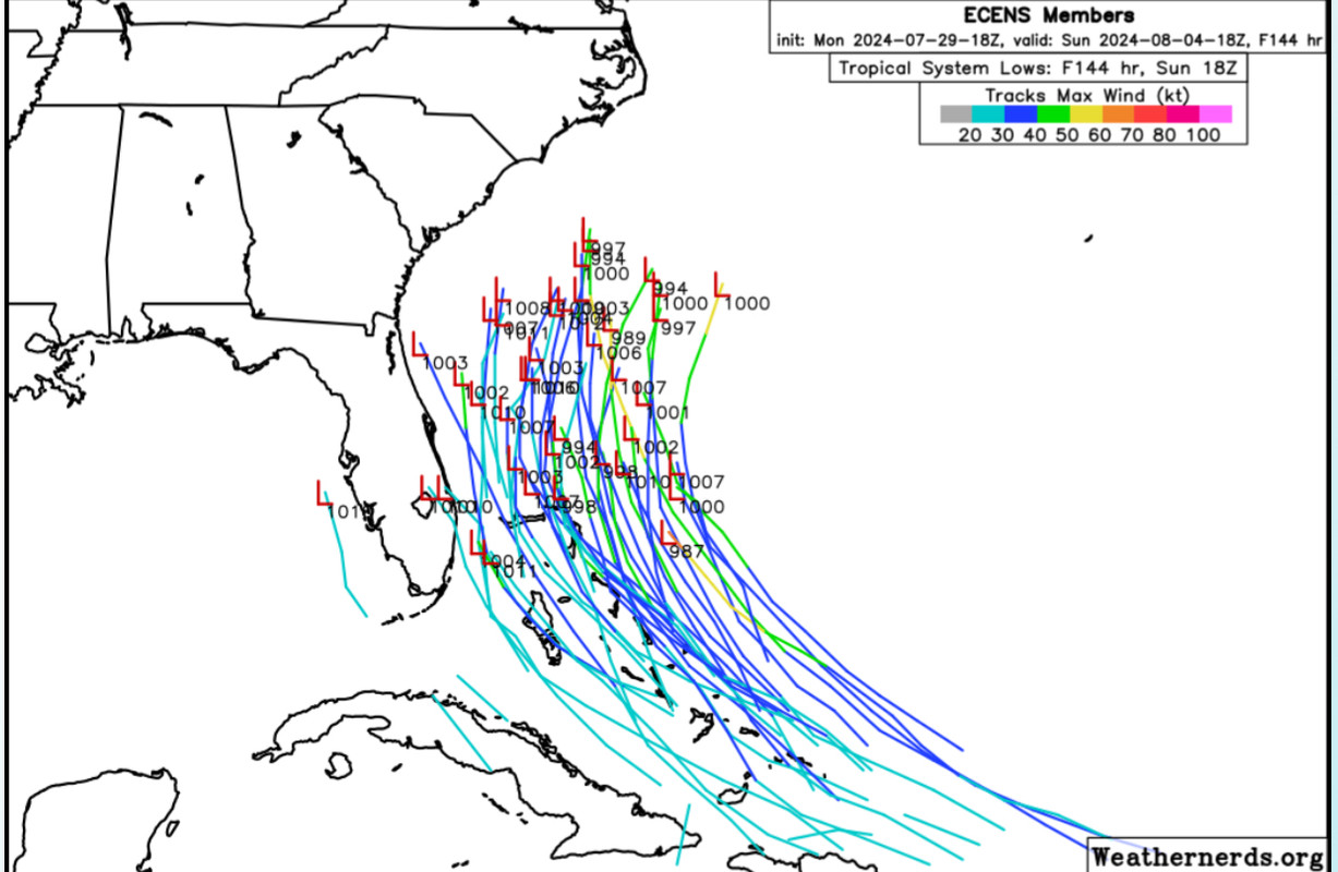
18z ECENS more active and west than 12z…
1 likes
Hurricane Eye Experience: David 79, Irene 99, Frances 04, Jeanne 04, Wilma 05… Hurricane Brush Experience: Andrew 92, Erin 95, Floyd 99, Matthew 16, Irma 17, Ian 22, Nicole 22…
Re: Possible development in the central Atlantic (0/50)
0z icon has shifted right again toward Euro, and now stays east of Florida, but goes through Bahamas and just stays offshore all the way to the outer banks and then out to sea, but gets up to hurricane strength as it passes by the OBX.
1 likes
-
Stratton23
- Category 5
- Posts: 3563
- Joined: Fri Jul 21, 2023 10:59 pm
- Location: Katy, Tx
Re: Possible development in the central Atlantic (0/50)
00z CMC has less defined weakness off the se coast isnt as defined as it was in precious runs, little more ridging this run, closer to florida , trough/ shortwave is trending east and weaker
1 likes
-
Stratton23
- Category 5
- Posts: 3563
- Joined: Fri Jul 21, 2023 10:59 pm
- Location: Katy, Tx
Re: Possible development in the central Atlantic (0/50)
GFS has a more developed system that gets trapped underneath ridging in the gulf, headed west-1002 mb to the south of new orleans
0 likes
Re: Possible development in the central Atlantic (0/50)
0Z UKMET: large shift SW and much earlier TCG just N of C Cuba with TS near Key West then turns into FL Big Bend followed by NNE motion into SC/SE GA, NE into coastal SC and then ENE move to offshore CHS; TS nearly the entire track
NEW TROPICAL CYCLONE FORECAST TO DEVELOP AFTER 102 HOURS
FORECAST POSITION AT T+102 : 22.8N 79.2W
LEAD CENTRAL MAXIMUM WIND
VERIFYING TIME TIME POSITION PRESSURE (MB) SPEED (KNOTS)
-------------- ---- -------- ------------- -------------
1200UTC 03.08.2024 108 23.3N 79.9W 1007 37
0000UTC 04.08.2024 120 24.8N 81.8W 1004 39
1200UTC 04.08.2024 132 26.9N 83.2W 1003 37
0000UTC 05.08.2024 144 28.9N 83.0W 1003 33
1200UTC 05.08.2024 156 31.4N 82.5W 1008 36
0000UTC 06.08.2024 168 32.8N 79.4W 1006 35
Last edited by LarryWx on Mon Jul 29, 2024 11:37 pm, edited 2 times in total.
0 likes
Personal Forecast Disclaimer:
The posts in this forum are NOT official forecasts and should not be used as such. They are just the opinion of the poster and may or may not be backed by sound meteorological data. They are NOT endorsed by any professional institution or storm2k.org. For official information, please refer to the NHC and NWS products.
The posts in this forum are NOT official forecasts and should not be used as such. They are just the opinion of the poster and may or may not be backed by sound meteorological data. They are NOT endorsed by any professional institution or storm2k.org. For official information, please refer to the NHC and NWS products.
-
Stratton23
- Category 5
- Posts: 3563
- Joined: Fri Jul 21, 2023 10:59 pm
- Location: Katy, Tx
Re: Possible development in the central Atlantic (0/50)
GFS down to 991 MB, south of vermillion bay and still moving west, interesting
0 likes
Re: Possible development in the central Atlantic (0/50)
Model bifurcation comes down to the ULL situated at roughly 35N 55W. Euro and most other models lift it north starting in a day. The GFS pushes it south around the same time. This shifts anticyclone development north of/just south of the Greater Antilles respectively. The wave envelope is large enough to potentially develop from either side, but vorticity will be higher to the north so it'll be a lot quicker to spin up if an anticyclone situated there. The flip side is this outcome has a clearer route for a recurve.
0 likes
Kendall -> SLO -> PBC
Memorable Storms: Katrina (for its Florida landfall...) Wilma Matthew Irma
Memorable Storms: Katrina (for its Florida landfall...) Wilma Matthew Irma
-
Stratton23
- Category 5
- Posts: 3563
- Joined: Fri Jul 21, 2023 10:59 pm
- Location: Katy, Tx
Re: Possible development in the central Atlantic (0/50)
GFS goes into galveston as a strong cat 1, we will see, but a very interesting trend tonight, more of the gulf could be possibly at risk than previously thought
0 likes
Re: Possible development in the central Atlantic (0/50)
Stratton23 wrote:00z CMC has less defined weakness off the se coast isnt as defined as it was in precious runs, little more ridging this run, closer to florida , trough/ shortwave is trending east and weaker
Then 0Z CMC gets to H strength off of NC followed by move to just off NE Nova Scotia at 240.
0 likes
Personal Forecast Disclaimer:
The posts in this forum are NOT official forecasts and should not be used as such. They are just the opinion of the poster and may or may not be backed by sound meteorological data. They are NOT endorsed by any professional institution or storm2k.org. For official information, please refer to the NHC and NWS products.
The posts in this forum are NOT official forecasts and should not be used as such. They are just the opinion of the poster and may or may not be backed by sound meteorological data. They are NOT endorsed by any professional institution or storm2k.org. For official information, please refer to the NHC and NWS products.
Re: Possible development in the central Atlantic (0/50)
Hard to take the GFS seriously with how inconsistent it has been for this AOI. A lot of time for things to change but I think the Euro has a better handle on how things will play out.
3 likes
Who is online
Users browsing this forum: Hurricane2022, mixedDanilo.E and 312 guests