
Possible development in the Western Atlantic / GOM (Is Invest 97L)
Moderator: S2k Moderators
Forum rules

The posts in this forum are NOT official forecasts and should not be used as such. They are just the opinion of the poster and may or may not be backed by sound meteorological data. They are NOT endorsed by any professional institution or STORM2K. For official information, please refer to products from the National Hurricane Center and National Weather Service.
-
cycloneye

- Admin

- Posts: 149716
- Age: 69
- Joined: Thu Oct 10, 2002 10:54 am
- Location: San Juan, Puerto Rico
Re: Possible development in the Western Atlantic (0/60)
More convection that I thought was going to have in this area.
3 likes
Visit the Caribbean-Central America Weather Thread where you can find at first post web cams,radars
and observations from Caribbean basin members Click Here
and observations from Caribbean basin members Click Here
Re: Possible development in the Western Atlantic (0/60)
cycloneye wrote:More convection that I thought was going to have in this area.
https://i.imgur.com/B4BEHqz.gif
Picking up moisture for sure. If you like watching paint dry, this one is for you. Lol
0 likes

Re: Possible development in the Western Atlantic (0/60)
06Z GFS I'll give you a hint "oranges"
0 likes
-
jlauderdal
- S2K Supporter

- Posts: 7240
- Joined: Wed May 19, 2004 5:46 am
- Location: NE Fort Lauderdale
- Contact:
Re: Possible development in the Western Atlantic (0/60)
Nimbus wrote:06Z GFS I'll give you a hint "oranges"
Thats a fast mover after it makes landfall
0 likes

Re: Possible development in the Western Atlantic (0/60)
6z GFS really focuses the vorticity southwest of Hispaniola by late tomorrow. Ends up as a hurricane in the Florida Panhandle and lingers for 6 days.


Sent from my iPad using Tapatalk
Sent from my iPad using Tapatalk
0 likes

Re: Possible development in the Western Atlantic (0/60)
Nimbus wrote:06Z GFS I'll give you a hint "oranges"
Major hurricane along Gulf Coast impacting Florida panhandle that drifts just offshore and slowly moves west toward NO. Yikes! But 7 to 10 days out so fantasy at this point.
1 likes
-
toad strangler

- S2K Supporter
- Posts: 4546
- Joined: Sun Jul 28, 2013 3:09 pm
- Location: Earth
- Contact:
Re: Possible development in the Western Atlantic (0/60)
ronjon wrote:Nimbus wrote:06Z GFS I'll give you a hint "oranges"
Major hurricane along Gulf Coast impacting Florida panhandle that drifts just offshore and slowly moves west toward NO. Yikes! But 7 to 10 days out so fantasy at this point.
There have been several models doing a long term stall in various places. The Euro was one in earlier runs in SC. Wild model output the past few days. I guess that should be expected when there is no coherent system to hone in on. I expect more of it
2 likes
My Weather Station
https://www.wunderground.com/dashboard/pws/KFLPORTS603
https://www.wunderground.com/dashboard/pws/KFLPORTS603
-
toad strangler
- S2K Supporter
- Posts: 4546
- Joined: Sun Jul 28, 2013 3:09 pm
- Location: Earth
- Contact:
Re: Possible development in the Western Atlantic (0/60)
6z Euro is complete weak sauce through 90. Looks like into or bouncing off SE FL but it's hard to tell with Storm Vistas crappy graphical output and my not so professional eyes lol. Looks very strung out too.
0 likes
My Weather Station
https://www.wunderground.com/dashboard/pws/KFLPORTS603
https://www.wunderground.com/dashboard/pws/KFLPORTS603
Re: Possible development in the Western Atlantic (0/60)
I noticed the Euro in its 00z run now splits the vorticity of this wave with one piece off SW FL in the GOM and the other in the SW Atlantic off SE coast. Seems the Euro might slowly be edging toward the GFS solution.
1 likes

Re: Possible development in the Western Atlantic (0/60)
Crazy big difference in the short-med term between the GFS and Euro in ~48 hrs through 120 hrs. The GFS shows a western extension of the ridge to the north of the disturbance further west than what the Euro forecasts thus the mid level vorticity along with the surface vorticity tracking through Hispaniola and to the south of eastern Cuba towards the SE GOM while the Euro shows less of a western extension of the ridge and the disturbance feel the weakness from the mid level shortwave coming through the eastern US.
What I have noticed is that the Euro has been trending towards the GFS in the short term.

What I have noticed is that the Euro has been trending towards the GFS in the short term.
4 likes

Re: Possible development in the Western Atlantic (0/60)
NDG wrote:Crazy big difference in the short-med term between the GFS and Euro in ~48 hrs through 120 hrs. The GFS shows a western extension of the ridge to the north of the disturbance further west than what the Euro forecasts thus the mid level vorticity along with the surface vorticity tracking through Hispaniola and to the south of eastern Cuba towards the SE GOM while the Euro shows less of a western extension of the ridge and the disturbance feel the weakness from the mid level shortwave coming through the eastern US.
What I have noticed is that the Euro has been trending towards the GFS in the short term.
https://i.imgur.com/twpVBgE.gif
That is a big difference, how soon will we know which one verifies?
0 likes
-
crownweather

- S2K Supporter
- Posts: 602
- Age: 51
- Joined: Sat Aug 12, 2006 9:21 am
- Location: Sturbridge, Massachusetts
- Contact:
Re: Possible development in the Western Atlantic (0/60)
With the increasing convection and all of models now showing at least some development, I suspect we’ll see an Invest tag later today.
Sent from my iPhone using Tapatalk
Sent from my iPhone using Tapatalk
2 likes
Rob Lightbown
Crown Weather Services
https://crownweather.com
Crown Weather Services
https://crownweather.com
-
REDHurricane

- Category 1

- Posts: 438
- Age: 28
- Joined: Sun Jul 03, 2022 2:36 pm
- Location: Northeast Pacific Ocean
Re: Possible development in the Western Atlantic (0/60)
NDG wrote:Crazy big difference in the short-med term between the GFS and Euro in ~48 hrs through 120 hrs. The GFS shows a western extension of the ridge to the north of the disturbance further west than what the Euro forecasts thus the mid level vorticity along with the surface vorticity tracking through Hispaniola and to the south of eastern Cuba towards the SE GOM while the Euro shows less of a western extension of the ridge and the disturbance feel the weakness from the mid level shortwave coming through the eastern US.
What I have noticed is that the Euro has been trending towards the GFS in the short term.
https://i.imgur.com/twpVBgE.gif
GFS appears to show a vorticity center forming on the downslope of Hispaniola's mountains right as it gets back over water:
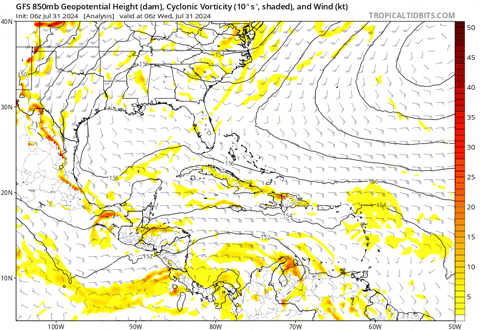
Whereas ECMWF keeps it as the broad wave it is right now:
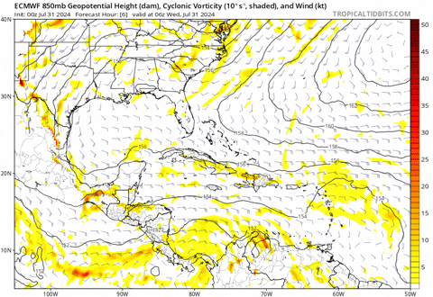
Are there examples of systems that have developed in a similar way to what GFS is showing, or could this be just another version of the early-season runs where it constantly tries to spin up disturbances out of nowhere as they come off the mountainous terrain of Colombia/Venezuela? I honestly don't know much about the GFS vs. ECMWF and their specific biases, what causes them, which things to look out for, etc. so I'd be interested to see if anyone here could shed some more light on this.
Last edited by REDHurricane on Wed Jul 31, 2024 7:58 am, edited 4 times in total.
0 likes
-
DunedinDave
- Category 1
- Posts: 269
- Joined: Fri Aug 25, 2023 10:31 am
Re: Possible development in the Western Atlantic (0/60)
So is it me or does anyone else get Elena vibes when they see the GFS?
Btw, you want a good ole GFS vs Euro battle, this is it because they’re on opposite sides of the spectrum here.
Btw, you want a good ole GFS vs Euro battle, this is it because they’re on opposite sides of the spectrum here.
1 likes
-
tolakram
- Admin
- Posts: 20186
- Age: 62
- Joined: Sun Aug 27, 2006 8:23 pm
- Location: Florence, KY (name is Mark)
Re: Possible development in the Western Atlantic (0/60)
GFS west of Florida
ICON over Florida
Euro east of Florida
I think it stays sloppy and unorganized over Florida. If it makes it into the gulf it will be in better conditions but I don't think this wave does it.
Just my opinion.
ICON over Florida
Euro east of Florida
I think it stays sloppy and unorganized over Florida. If it makes it into the gulf it will be in better conditions but I don't think this wave does it.
Just my opinion.
0 likes
M a r k
- - - - -
Join us in chat: Storm2K Chatroom Invite. Android and IOS apps also available.
The posts in this forum are NOT official forecasts and should not be used as such. Posts are NOT endorsed by any professional institution or STORM2K.org. For official information and forecasts, please refer to NHC and NWS products.
-
toad strangler
- S2K Supporter
- Posts: 4546
- Joined: Sun Jul 28, 2013 3:09 pm
- Location: Earth
- Contact:
-
wxman57

- Moderator-Pro Met

- Posts: 23175
- Age: 68
- Joined: Sat Jun 21, 2003 8:06 pm
- Location: Houston, TX (southwest)
Re: Possible development in the Western Atlantic (0/60)
DunedinDave wrote:So is it me or does anyone else get Elena vibes when they see the GFS?
Btw, you want a good ole GFS vs Euro battle, this is it because they’re on opposite sides of the spectrum here.
Yeah, that was my thought. I was forecasting Elena back in 1985. Told my mother, who lived on the MS coast, to buy a generator. When it looked like Elena might go to Florida, she was upset that she had spent the money. Elena turned west and raked the MS coast and she was without power for 3 weeks. That generator came in handy.
In this case, the GFS is the extreme outlier. I would not trust it. ICON, which did best with Beryl, has it passing east of Florida. Only 2 of the ICON ensembles take it into the eastern Gulf at all. With increasing convection, there is a greater chance of it staying east of Florida.
8 likes
-
REDHurricane
- Category 1
- Posts: 438
- Age: 28
- Joined: Sun Jul 03, 2022 2:36 pm
- Location: Northeast Pacific Ocean
Re: Possible development in the Western Atlantic (0/60)
toad strangler wrote:https://twitter.com/andyhazelton/status/1818611362769097040?s=46
And there's the answer to my question lol, Euro still seems like the more likely solution at this point then
2 likes

Re: Possible development in the Western Atlantic (0/60)
ronjon wrote:I noticed the Euro in its 00z run now splits the vorticity of this wave with one piece off SW FL in the GOM and the other in the SW Atlantic off SE coast. Seems the Euro might slowly be edging toward the GFS solution.
Yeah. I mentioned this question yesterday with the compressed timeframe and vastly different outputs. There could be two pieces of energy regardless if either or none at all form into anything classifiable. GFS landfall/stall at Santa Rosa/Okaloosa Counties would be after midnight Tuesday morning. So we're less than a week out with that solution. At that same time EC has it off the NC Coast. EC sucks it up the east coast being caught by the trough coming down.
https://www.tropicaltidbits.com/analysi ... 100&fh=144
GFS has it farther south and locks it in as the heat ridge builds back north of it
https://www.tropicaltidbits.com/analysi ... 106&fh=138
I feel like it being early August, the GFS's idea of the upper patter is better vs. if it was later in the season or into the fall. But I don't trust it that much, so I'm sticking with the more EC solution for now.
0 likes
-
Emmett_Brown

- Category 5

- Posts: 1433
- Joined: Wed Aug 24, 2005 9:10 pm
- Location: Sarasota FL
Re: Possible development in the Western Atlantic (0/60)
A lot of social media posts mentioning land interaction hindering development, or "breaking up the disturbance". Usually however, it is the land interaction that can act as a focusing mechanism to disturb the structure of the large envelop and focus it. Someone mentioned similarities to Elena; I am getting similar vibes. Elena formed from an African wave hindered by SAL. The wave crossed the big Greater Antilles islands, and a depression formed near the western tip of Cuba, and actually strengthened into a TS while over Cuba. Where the low level center actually forms is really a toss up, so the next couple of days are going to be interesting to watch.
3 likes
Who is online
Users browsing this forum: pepecool20, South Texas Storms and 245 guests