EPAC: CARLOTTA - Post-Tropical - Discussion
Moderator: S2k Moderators
-
Kingarabian

- S2K Supporter

- Posts: 16345
- Joined: Sat Aug 08, 2009 3:06 am
- Location: Honolulu, Hawaii
Re: EPAC: CARLOTTA - Tropical Storm - Discussion
With a small eye and CDO, Dvorak will need time to catch up. But this is likely a hurricane. Microwave imagery is having a hard time showing the eye due to its small size.
0 likes
RIP Kobe Bryant
-
Sciencerocks
- Category 5

- Posts: 10181
- Age: 40
- Joined: Thu Jul 06, 2017 1:51 am

-
cycloneye

- Admin

- Posts: 149263
- Age: 69
- Joined: Thu Oct 10, 2002 10:54 am
- Location: San Juan, Puerto Rico
Re: EPAC: CARLOTTA - Tropical Storm - Discussion
Tropical Storm Carlotta Discussion Number 6
NWS National Hurricane Center Miami FL EP032024
200 PM MST Thu Aug 01 2024
Carlotta has changed little in organization since the last
advisory, with satellite imagery showing a well-defined central
dense overcast with a complex of outer bands in the eastern
semicircle. Objective and subjective satellite intensity estimates
are mainly in the 45-55 kt range, and they have nudged upward a
little over the past six hours. Based on this, the initial
intensity is increased to 55 kt.
The initial motion is now 285/10 kt. Carlotta is on the south side
of a low- to mid-level ridge located over the southwestern United
States and the adjacent northeastern Pacific. The ridge is
expected to strengthen during the next day or two, and this should
steer the cyclone more westward during this time. After about 60
h, Carlotta should move west-northwestward as it approaches a
weakness in the mid-level part of the ridge caused by a large
trough over the north Central Pacific. The track guidance has
again shifted northward, and the new forecast track, which is in
best agreement with the HCCA corrected consensus model, has also
been shifted northward.
Carlotta is expected to remain in an area of light shear for the
next 48 h, with sea surface temperatures slowly decreasing along
the forecast track during that time. Thus strengthening is
expected, although the intensity guidance is forecasting less
strengthening than on the previous cycles. Based on this, the
forecast peak intensity has been decreased slightly, and the 85-kt
peak intensity forecast is at the high end of the intensity
guidance. After 48 h, increasing westerly shear and decreasing sea
surface temperatures should cause Carlotta to weaken for the
remainder of the forecast period.
FORECAST POSITIONS AND MAX WINDS
INIT 01/2100Z 17.5N 111.9W 55 KT 65 MPH
12H 02/0600Z 17.9N 113.6W 65 KT 75 MPH
24H 02/1800Z 18.2N 115.7W 75 KT 85 MPH
36H 03/0600Z 18.4N 117.9W 85 KT 100 MPH
48H 03/1800Z 18.6N 120.1W 85 KT 100 MPH
60H 04/0600Z 18.9N 122.1W 80 KT 90 MPH
72H 04/1800Z 19.2N 123.9W 75 KT 85 MPH
96H 05/1800Z 19.5N 127.0W 60 KT 70 MPH
120H 06/1800Z 20.0N 130.0W 50 KT 60 MPH
$$
Forecaster Beven
0 likes
Visit the Caribbean-Central America Weather Thread where you can find at first post web cams,radars
and observations from Caribbean basin members Click Here
and observations from Caribbean basin members Click Here

Re: EPAC: CARLOTTA - Tropical Storm - Discussion
With how persistent the small CDO has been, I agree that this is likely a low-end hurricane, but the 00z BT holds at 55 kt.
0 likes
Irene '11 Sandy '12 Hermine '16 5/15/2018 Derecho Fay '20 Isaias '20 Elsa '21 Henri '21 Ida '21
I am only a meteorology enthusiast who knows a decent amount about tropical cyclones. Look to the professional mets, the NHC, or your local weather office for the best information.
I am only a meteorology enthusiast who knows a decent amount about tropical cyclones. Look to the professional mets, the NHC, or your local weather office for the best information.
-
DorkyMcDorkface

- Category 4

- Posts: 984
- Age: 28
- Joined: Mon Sep 30, 2019 1:32 pm
- Location: Mid-Atlantic
Re: EPAC: CARLOTTA - Tropical Storm - Discussion
0 likes
Please note the thougths expressed by this account are solely those of the user and are from a hobbyist perspective. For more comprehensive analysis, consult an actual professional meteorologist or meteorology agency.
Floyd 1999 | Isabel 2003 | Hanna 2008 | Irene 2011 | Sandy 2012 | Isaias 2020
-
Sciencerocks
- Category 5
- Posts: 10181
- Age: 40
- Joined: Thu Jul 06, 2017 1:51 am

-
cycloneye
- Admin
- Posts: 149263
- Age: 69
- Joined: Thu Oct 10, 2002 10:54 am
- Location: San Juan, Puerto Rico
Re: EPAC: CARLOTTA - Tropical Storm - Discussion
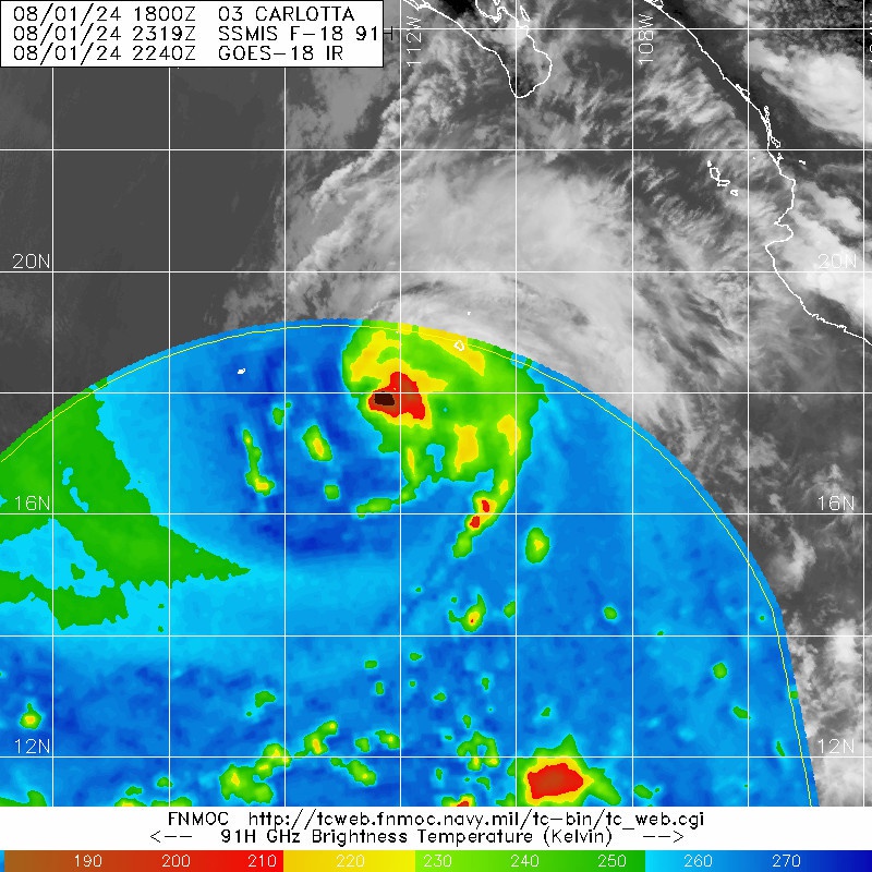
Tropical Storm Carlotta Discussion Number 7
NWS National Hurricane Center Miami FL EP032024
800 PM MST Thu Aug 01 2024
Carlotta continues to hold steady. Geostationary satellite imagery
show a healthy central dense overcast with periodic overshooting
cloud tops. Recent microwave satellite imagery from AMSR2 and
SSMIS reveal a more asymmetric low-level circulation. Subjective
and objective satellite intensity estimates range between 48-61 kt,
and the initial intensity is held at 55 kt.
The storm is moving at an estimated 285/10 kt along the south side
of a mid-level ridge centered over the southwestern United States.
The strengthening ridge is expected to turn Carlotta westward within
a day or so and steer the storm slightly north of west for the
remainder of the forecast period. The official forecast has again
shifted slightly northward, largely due to the estimated initial
center location, and lies closest to the HCCA corrected consensus
model.
While the deep layer vertical wind shear appears to be weak, the
microwave satellite imagery suggested Carlotta could be experiencing
some moderate mid-level shear. Models indicate the generally
conducive environmental and oceanic conditions should allow for
additional strengthening within the next day or two. Beyond 48 h,
cooling waters and more marginal environmental conditions should
weaken Carlotta through the end of the forecast period. The
intensity forecast remains similar to the previous forecast and lies
near the top of the guidance envelope.
FORECAST POSITIONS AND MAX WINDS
INIT 02/0300Z 17.9N 112.8W 55 KT 65 MPH
12H 02/1200Z 18.3N 114.5W 65 KT 75 MPH
24H 03/0000Z 18.6N 116.7W 75 KT 85 MPH
36H 03/1200Z 18.8N 119.0W 85 KT 100 MPH
48H 04/0000Z 19.1N 121.1W 80 KT 90 MPH
60H 04/1200Z 19.4N 123.0W 75 KT 85 MPH
72H 05/0000Z 19.7N 124.8W 70 KT 80 MPH
96H 06/0000Z 20.2N 128.0W 55 KT 65 MPH
120H 07/0000Z 20.5N 131.0W 40 KT 45 MPH
$$
Forecaster Bucci
0 likes
Visit the Caribbean-Central America Weather Thread where you can find at first post web cams,radars
and observations from Caribbean basin members Click Here
and observations from Caribbean basin members Click Here
-
Yellow Evan

- Professional-Met

- Posts: 16231
- Age: 27
- Joined: Fri Jul 15, 2011 12:48 pm
- Location: Henderson, Nevada/Honolulu, HI
- Contact:
Re: EPAC: CARLOTTA - Tropical Storm - Discussion
EP, 03, 2024080206, , BEST, 0, 180N, 1133W, 60, 991, TS, 50, NEQ, 30, 20, 0, 30, 1011, 180, 10, 0, 0, E, 0, , 0, 0, CARLOTTA, D, 0, , 0, 0, 0, 0, genesis-num, 013,
0 likes
-
Yellow Evan
- Professional-Met
- Posts: 16231
- Age: 27
- Joined: Fri Jul 15, 2011 12:48 pm
- Location: Henderson, Nevada/Honolulu, HI
- Contact:
Re: EPAC: CARLOTTA - Tropical Storm - Discussion
ASCAT with undersampling correction supports upgrade into a hurricane. Additionally, convective structure has become more hurricane like in recent frames, with convection wrapping around efficiently.
1 likes
-
cycloneye
- Admin
- Posts: 149263
- Age: 69
- Joined: Thu Oct 10, 2002 10:54 am
- Location: San Juan, Puerto Rico
Re: EPAC: CARLOTTA - Tropical Storm - Discussion
Tropical Storm Carlotta Discussion Number 8
NWS National Hurricane Center Miami FL EP032024
200 AM MST Fri Aug 02 2024
Recent scatterometer data indicate the center of Carlotta remains
embedded within a small central dense overcast as deep convection
has persisted near and over the center tonight. Satellite images
indicate the upper-level outflow is somewhat restricted over the
western part of the circulation, perhaps the result of some westerly
shear. The latest objective and subjective satellite intensity
estimates range from 54-65 kt, and the initial intensity is raised
to 60 kt for this advisory. The initial tropical-storm-force wind
field of Carlotta has been made slightly larger than previous
estimates based on the scatterometer winds.
Carlotta is moving west-northwestward (285/10 kt), but a turn toward
the west is expected later today as a ridge strengthens to the north
of the cyclone. A continued westward to west-northwestward motion is
forecast through early next week. The model guidance has once again
trended northward this cycle, and the latest NHC track forecast is
adjusted in that direction, mainly in the 72-120 h time frame. Based
on the multi-model consensus aids, the updated prediction is also
slightly faster than the previous one during the latter half of the
forecast period.
The environmental and oceanic conditions are generally favorable for
strengthening during the next couple of days. However, there remains
some dry air in the surrounding environment that has at times
disrupted Carlotta's organization in recent days given its small
size. Assuming the inner core structure has improved based on recent
convective trends, additional strengthening seems likely during the
next 24-36 h. The NHC forecast remains on the high end of the
guidance envelope, generally between the HFIP corrected consensus
and the stronger HAFS-A/B regional models. Since Carlotta is a small
cyclone, it could be susceptible to rapid intensity fluctuations.
The storm is forecast to reach the 26C isotherm in about 60-72 h.
Thereafter, weakening is forecast while Carlotta encounters cooler
SSTs, increasing shear, and decreasing mid-level moisture.
FORECAST POSITIONS AND MAX WINDS
INIT 02/0900Z 18.2N 113.8W 60 KT 70 MPH
12H 02/1800Z 18.6N 115.5W 75 KT 85 MPH
24H 03/0600Z 18.9N 117.9W 85 KT 100 MPH
36H 03/1800Z 19.2N 120.2W 85 KT 100 MPH
48H 04/0600Z 19.4N 122.3W 80 KT 90 MPH
60H 04/1800Z 19.7N 124.3W 65 KT 75 MPH
72H 05/0600Z 20.2N 126.2W 55 KT 65 MPH
96H 06/0600Z 21.0N 129.0W 45 KT 50 MPH
120H 07/0600Z 21.5N 132.0W 35 KT 40 MPH
$$
Forecaster Reinhart
0 likes
Visit the Caribbean-Central America Weather Thread where you can find at first post web cams,radars
and observations from Caribbean basin members Click Here
and observations from Caribbean basin members Click Here
-
cycloneye
- Admin
- Posts: 149263
- Age: 69
- Joined: Thu Oct 10, 2002 10:54 am
- Location: San Juan, Puerto Rico
Re: EPAC: CARLOTTA - Tropical Storm - Discussion
Hurricane Carlotta.
EP, 03, 2024080212, , BEST, 0, 185N, 1146W, 70, 983, HU,
1 likes
Visit the Caribbean-Central America Weather Thread where you can find at first post web cams,radars
and observations from Caribbean basin members Click Here
and observations from Caribbean basin members Click Here
-
cycloneye
- Admin
- Posts: 149263
- Age: 69
- Joined: Thu Oct 10, 2002 10:54 am
- Location: San Juan, Puerto Rico
Re: EPAC: CARLOTTA - Hurricane - Discussion
At 800 AM PDT (1500 UTC), the center of Hurricane Carlotta was
located near latitude 18.6 North, longitude 115.2 West. Carlotta is
moving toward the west-northwest near 14 mph (22 km/h) and a
continued west-northwestward motion with a gradual slowdown is
anticipated over the next several days.
Maximum sustained winds have increase to near 80 mph (130 km/h) with
higher gusts. Additional strengthening is forecast during the next
day or so, followed by some weakening by early next week.
Hurricane-force winds extend outward up to 10 miles (20 km) from the
center and tropical-storm-force winds extend outward up to 80 miles
(130 km). Earlier, a Mexican Navy automated station on Isla Clarion
reported a sustained wind of 55 mph (86 km/h) and a gust of 81 mph
(130 km/h).
The estimated minimum central pressure is 983 mb (29.03 inches).
Earlier, a Mexican Navy automated station on Isla Clarion reported a
minimum pressure of 986 mb (29.11 inches).
Hurricane Carlotta Discussion Number 9
NWS National Hurricane Center Miami FL EP032024
800 AM PDT Fri Aug 02 2024
Since the previous advisory, Carlotta's structure on satellite
imagery has improved, with a banding eye showing up on both infrared
and visible frames. We have been also receiving helpful surface
observations from Isla Clarion which earlier reported sustained
winds of 47 kt with a gust of 71 kt and a minimum pressure of 986 mb
as Carlotta passed by just to the north. These data, along with
subjective and objective intensity estimates in the 65-77 kt range
are the basis to increase the initial intensity to 70 kt, making
Carlotta the first hurricane of the East Pacific season.
Carlotta continues to move west-northwestward, estimated at
285/12-kt. This heading with a gradual slowdown is expected to
continue for the next several days as the hurricane remains
influenced by a large deep-layer ridge centered over the
southwestern United States. The track guidance this cycle has not
changed much other than another subtle shift north again, and the
NHC track forecast was nudged again in that direction.
The small hurricane has an opportunity to intensify further over the
next day or so while it remains over warm ocean waters and low to
moderate vertical wind shear. Similar to the previous advisory, the
NHC forecast continues to show a peak intensity as a Category 2
hurricane in 24-36 hours. However beyond that time, sea-surface
temperatures decrease under 26 C and continue to cool as the
environmental moisture becomes increasingly dry and stable. Thus,
weakening should begin in earnest after that time period, with the
system becoming post-tropical as it loses its remaining convection
by the end of the forecast period.
FORECAST POSITIONS AND MAX WINDS
INIT 02/1500Z 18.6N 115.2W 70 KT 80 MPH
12H 03/0000Z 18.9N 117.0W 80 KT 90 MPH
24H 03/1200Z 19.3N 119.3W 85 KT 100 MPH
36H 04/0000Z 19.6N 121.5W 85 KT 100 MPH
48H 04/1200Z 19.9N 123.6W 75 KT 85 MPH
60H 05/0000Z 20.3N 125.5W 60 KT 70 MPH
72H 05/1200Z 20.8N 127.4W 50 KT 60 MPH
96H 06/1200Z 21.6N 130.5W 40 KT 45 MPH
120H 07/1200Z 22.0N 134.0W 35 KT 40 MPH...POST-TROPICAL
$$
Forecaster Papin
0 likes
Visit the Caribbean-Central America Weather Thread where you can find at first post web cams,radars
and observations from Caribbean basin members Click Here
and observations from Caribbean basin members Click Here
-
Sciencerocks
- Category 5
- Posts: 10181
- Age: 40
- Joined: Thu Jul 06, 2017 1:51 am

-
Yellow Evan
- Professional-Met
- Posts: 16231
- Age: 27
- Joined: Fri Jul 15, 2011 12:48 pm
- Location: Henderson, Nevada/Honolulu, HI
- Contact:
Re: EPAC: CARLOTTA - Hurricane - Discussion
Eye clearing but it’s still battling dry air. Need deeper convection to re-develop.
0 likes


-
weeniepatrol

- Category 5
- Posts: 1340
- Joined: Sat Aug 22, 2020 5:30 pm
- Location: WA State
Re: EPAC: CARLOTTA - Hurricane - Discussion
Travorum wrote:https://i.imgur.com/4M0dqD5.jpeg
Nothing but respect for this level of hating
I believe only 2003 had a later first hurricane?
1 likes
-
Kingarabian
- S2K Supporter
- Posts: 16345
- Joined: Sat Aug 08, 2009 3:06 am
- Location: Honolulu, Hawaii
Re: EPAC: CARLOTTA - Hurricane - Discussion
Looks like a Cat 2. I would go 80kts.
0 likes
RIP Kobe Bryant
-
cycloneye
- Admin
- Posts: 149263
- Age: 69
- Joined: Thu Oct 10, 2002 10:54 am
- Location: San Juan, Puerto Rico
Re: EPAC: CARLOTTA - Hurricane - Discussion
0 likes
Visit the Caribbean-Central America Weather Thread where you can find at first post web cams,radars
and observations from Caribbean basin members Click Here
and observations from Caribbean basin members Click Here
-
cycloneye
- Admin
- Posts: 149263
- Age: 69
- Joined: Thu Oct 10, 2002 10:54 am
- Location: San Juan, Puerto Rico
Re: EPAC: CARLOTTA - Hurricane - Discussion
[Xpost]EP, 03, 2024080218, , BEST, 0, 186N, 1158W, 75, 981, HU[/Xpost]
0 likes
Visit the Caribbean-Central America Weather Thread where you can find at first post web cams,radars
and observations from Caribbean basin members Click Here
and observations from Caribbean basin members Click Here
-
Sciencerocks
- Category 5
- Posts: 10181
- Age: 40
- Joined: Thu Jul 06, 2017 1:51 am

Who is online
Users browsing this forum: No registered users and 31 guests