ATL: DEBBY - Models

Moderator: S2k Moderators

Message
Author
BobHarlem
Category 5
Category 5
Posts: 2034
Joined: Thu Oct 20, 2005 6:11 pm

Re: ATL: INVEST 97L - Models

#81 Postby BobHarlem » Thu Aug 01, 2024 6:49 pm

Hafs A and b:

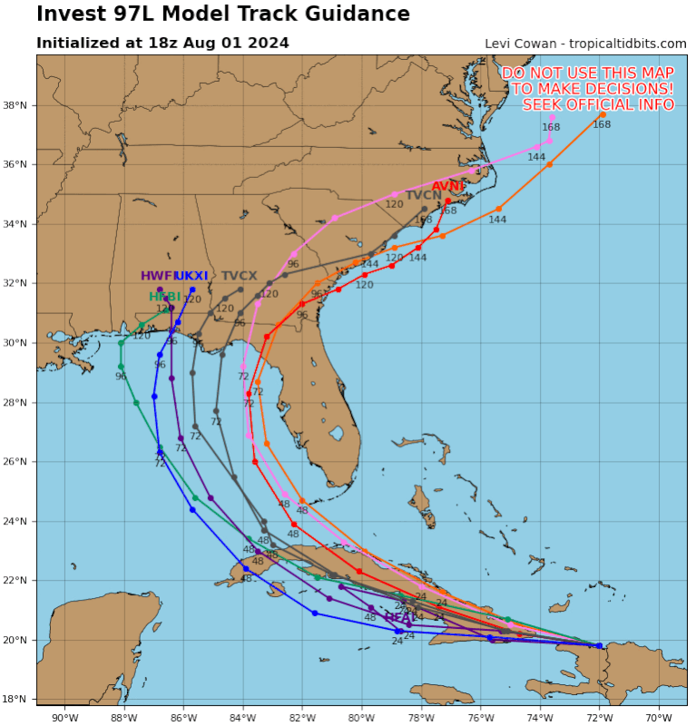
A didn't get lost this time but both struggled with genesis.
HafsA loops and stalls near the Big Bend and never leaves north Florida for the rest of the run.
Image
Image


HafsB, faster, right of prior run. But stalls here for about 24 hours before moving slightly further north, but still in Florida (Just south of GA border) by hour 117 the drifts back closer to the Gulf/Big Bend by the end of the run on 0z Wed.
Image
Last edited by BobHarlem on Thu Aug 01, 2024 7:12 pm, edited 4 times in total.
0 likes   

BobHarlem
Category 5
Category 5
Posts: 2034
Joined: Thu Oct 20, 2005 6:11 pm

Re: ATL: INVEST 97L - Models

#82 Postby BobHarlem » Thu Aug 01, 2024 6:54 pm

18z hwrf/hmon
18z HMON: Landfall here, doesn't really slow down much. way right of 12z (Which was at Mobile, AL) the crawls slowly north along the AL/GA border. Where it basically stalls for the rest of the run (GA side of the AL/FL/GA border area near Bainbridge)
Image


18z HWRF slightly right, not quite as strong as 12z. drifts into Southern Georgia after landfall.
Image
0 likes   

User avatar
Woofde
Category 1
Category 1
Posts: 475
Joined: Tue Jul 06, 2021 11:33 am

Re: ATL: INVEST 97L - Models

#83 Postby Woofde » Thu Aug 01, 2024 7:42 pm

BobHarlem wrote:18z hwrf/hmon
18z HMON: Landfall here, doesn't really slow down much. way right of 12z (Which was at Mobile, AL) the crawls slowly north along the AL/GA border. Where it basically stalls for the rest of the run (GA side of the AL/FL/GA border area near Bainbridge)
Image


18z HWRF slightly right, not quite as strong as 12z. drifts into Southern Georgia after landfall.
Image
Notably both the HWRF and HMON both become hurricanes. Its a little early to read into the Hurricane models because theres no circulation yet. That said I've noticed throughout the years that storms without early support from those two tend to fail pretty hard. So it is a sign of potential IMO.

In theory we should look towards HAFS as they should outperform the older models, but we've seen them struggle with some storms (Beryl being the most recent example). I'm glad they still run the older models.
0 likes   

User avatar
wzrgirl1
S2K Supporter
S2K Supporter
Posts: 1323
Joined: Sat Sep 04, 2004 6:44 am
Location: Pembroke Pines, Florida

Re: ATL: INVEST 97L - Models

#84 Postby wzrgirl1 » Thu Aug 01, 2024 7:43 pm

Nimbus wrote:12Z HMON had the worst track, finds the keys to the M.G. and tracks over water all the way to NOLA.


MG?
0 likes   

User avatar
ColdFusion
S2K Supporter
S2K Supporter
Posts: 443
Joined: Wed Feb 13, 2008 3:46 pm
Location: Addison, TX

Re: ATL: INVEST 97L - Models

#85 Postby ColdFusion » Thu Aug 01, 2024 8:07 pm

wzrgirl1 wrote:MG?


Mardi Gras
1 likes   

User avatar
ronjon
Category 5
Category 5
Posts: 4811
Joined: Fri Aug 19, 2005 5:17 pm
Location: Hernando Beach, FL

Re: ATL: INVEST 97L - Models

#86 Postby ronjon » Thu Aug 01, 2024 8:09 pm

Pretty good consistency among the 18z hurricane models through 84 hrs. ICON stayed consistent at 18z vs 12z. Euro has similar track as aforementioned models but continues to struggle with intensity with weak low. GFS track is now on the east side of most guidance. Watching this one closely on the west coast of FL.
1 likes   

User avatar
Gums
S2K Supporter
S2K Supporter
Posts: 169
Age: 82
Joined: Sun Oct 07, 2018 7:30 pm
Location: Niceville, FL

2024 Global Model Runs Discussion (Out thru day 16)

#87 Postby Gums » Thu Aug 01, 2024 8:10 pm

Salute!

NHC talking bad news. Where are all the other models?

Hoping for a strong recurve into the low population big bend.

Gums sends...
0 likes   

User avatar
SFLcane
S2K Supporter
S2K Supporter
Posts: 10162
Age: 47
Joined: Sat Jun 05, 2010 1:44 pm
Location: Lake Worth Florida

Re: ATL: INVEST 97L - Models

#88 Postby SFLcane » Thu Aug 01, 2024 8:13 pm

Image
2 likes   

BobHarlem
Category 5
Category 5
Posts: 2034
Joined: Thu Oct 20, 2005 6:11 pm

Re: ATL: INVEST 97L - Models

#89 Postby BobHarlem » Thu Aug 01, 2024 8:13 pm

0z shows Right shift on most of the earlies compared to 18z
Image
0 likes   

User avatar
Nimbus
Category 5
Category 5
Posts: 5274
Joined: Mon Jul 19, 2004 10:54 am

Re: ATL: INVEST 97L - Models

#90 Postby Nimbus » Thu Aug 01, 2024 8:19 pm

wzrgirl1 wrote:
Nimbus wrote:12Z HMON had the worst track, finds the keys to the M.G. and tracks over water all the way to NOLA.


MG?


The circulation is blowing south over Cuba and the lift is creating thunderstorms near Montego Bay.
The 12Z HMON initialized way far south and stayed south of Cuba.
0 likes   

User avatar
DorkyMcDorkface
Category 3
Category 3
Posts: 820
Age: 27
Joined: Mon Sep 30, 2019 1:32 pm
Location: Mid-Atlantic

Re: ATL: INVEST 97L - Models

#91 Postby DorkyMcDorkface » Thu Aug 01, 2024 8:19 pm

2 likes   
Please note the thougths expressed by this account are solely those of the user and are from a hobbyist perspective. For more comprehensive analysis, consult an actual professional meteorologist or meteorology agency.


Floyd 1999 | Isabel 2003 | Hanna 2008 | Irene 2011 | Sandy 2012 | Isaias 2020

User avatar
cycloneye
Admin
Admin
Posts: 143867
Age: 68
Joined: Thu Oct 10, 2002 10:54 am
Location: San Juan, Puerto Rico

Re: 2024 Global Model Runs Discussion (Out thru day 16)

#92 Postby cycloneye » Thu Aug 01, 2024 8:20 pm

Gums wrote:Salute!

NHC talking bad news. Where are all the other models?

Hoping for a strong recurve into the low population big bend.

Gums sends...


Hi. Moved your post to the 97L models thread.Which models you are referring to?
0 likes   
Visit the Caribbean-Central America Weather Thread where you can find at first post web cams,radars
and observations from Caribbean basin members Click Here

User avatar
wzrgirl1
S2K Supporter
S2K Supporter
Posts: 1323
Joined: Sat Sep 04, 2004 6:44 am
Location: Pembroke Pines, Florida

Re: ATL: INVEST 97L - Models

#93 Postby wzrgirl1 » Thu Aug 01, 2024 8:24 pm


Quite a shift east!!!
0 likes   

User avatar
ronjon
Category 5
Category 5
Posts: 4811
Joined: Fri Aug 19, 2005 5:17 pm
Location: Hernando Beach, FL

Re: ATL: INVEST 97L - Models

#94 Postby ronjon » Thu Aug 01, 2024 8:51 pm

wzrgirl1 wrote:


Quite a shift east!!!


In addition to the east shift, now a much tighter clustering of tracks of the various models through 84 hrs. One exception the UKMET.
1 likes   

User avatar
Hypercane_Kyle
Category 5
Category 5
Posts: 3344
Joined: Sat Mar 07, 2015 7:58 pm
Location: Cape Canaveral, FL

Re: ATL: INVEST 97L - Models

#95 Postby Hypercane_Kyle » Thu Aug 01, 2024 9:02 pm

This is a situation where I've seen the models struggle, hard. We have an open wave passing over the most mountainous regions of the Caribbean. All bets are off as to where the LLC truly forms. If the majority of the wave axis stays over Cuba and it doesn't become a TC until it reaches the Gulf, the ceiling is lower. If it can somehow establish a LLC north of Cuba, it'll run into Florida. If it can form one in the Caribbean just south of Cuba and follow the coastline, I think the situation will change dramatically.
1 likes   
My posts are my own personal opinion, defer to the National Hurricane Center (NHC) and other NOAA products for decision making during hurricane season.

BobHarlem
Category 5
Category 5
Posts: 2034
Joined: Thu Oct 20, 2005 6:11 pm

Re: ATL: INVEST 97L - Models

#96 Postby BobHarlem » Thu Aug 01, 2024 10:08 pm

0z icon, ever so slightly left of the 18z icon and slightly stronger.

Image

Exits into the Atlantic here then
Image

rides offshore just along the coast near SC... much closer than 12z
Image

Landfall at Oak Island, NC (Into Wilmington):
Image

Then stalls it over Eastern North Carolina through the end of the model run
Image

Later part of the model run is very left of the 12z, early part is only slightly left.
0 likes   

IcyTundra
Category 5
Category 5
Posts: 1205
Joined: Mon Jun 07, 2021 9:32 pm
Location: Dickinson, Texas

Re: ATL: INVEST 97L - Models

#97 Postby IcyTundra » Thu Aug 01, 2024 10:53 pm

BobHarlem wrote:0z icon, ever so slightly left of the 18z icon and slightly stronger.

https://i.imgur.com/jLkYOxt.png

Exits into the Atlantic here then
https://i.imgur.com/sdY2NlY.png

rides offshore just along the coast near SC... much closer than 12z
https://i.imgur.com/3vRFAJ2.png

Landfall at Oak Island, NC (Into Wilmington):
https://i.imgur.com/TGOhGgn.png

Then stalls it over Eastern North Carolina through the end of the model run
https://i.imgur.com/og9hkUk.png

Later part of the model run is very left of the 12z, early part is only slightly left.


Widespread area of rainfall over 12 inches on the ICON in NC and SC
1 likes   

BobHarlem
Category 5
Category 5
Posts: 2034
Joined: Thu Oct 20, 2005 6:11 pm

Re: ATL: INVEST 97L - Models

#98 Postby BobHarlem » Thu Aug 01, 2024 10:56 pm

May be a bit early to say but 0z gfs is slightly left, clips St. Pete then slows a lot straddling the shoreline just north of St. Pete. At least for a frame or so. and then slowly moving through Florida toward St. Augustine.

Image

exits near St. Augustine, south of 18z exit point
Image

After that it gets a bit further east in the Atlantic than 18z, but still winds up pretty close to 18z point by 93 hours, and a hurricane then.

By here it's about 8 mb stronger than the 18z at the same point in time.
Image

Solid cat 2 here (roughly 10mb stronger than 18z at same time)
Image

By this point the 0z veers right of the 18z, and is much less likely to make landfall
Image

And no landfall on 0z after Florida, out to sea it goes.
Last edited by BobHarlem on Thu Aug 01, 2024 11:25 pm, edited 3 times in total.
0 likes   

BobHarlem
Category 5
Category 5
Posts: 2034
Joined: Thu Oct 20, 2005 6:11 pm

Re: ATL: INVEST 97L - Models

#99 Postby BobHarlem » Thu Aug 01, 2024 11:14 pm

0z CMC is fast, for this to verify it would need to start moving NW right now.

Image
1 likes   

User avatar
ElectricStorm
Category 5
Category 5
Posts: 5017
Age: 24
Joined: Tue Aug 13, 2019 11:23 pm
Location: Skiatook, OK / Norman, OK

Re: ATL: INVEST 97L - Models

#100 Postby ElectricStorm » Fri Aug 02, 2024 12:59 am

0z HWRF further east and weaker, has mid-strong TS. HMON has a strong TS, close to Cat 1 hurricane. HAFS-A and B both have a minimal hurricane before landfall as a TS.

Interestingly, all four have this making landfall as a weakening storm rather than a strengthening one.
0 likes   
I am in no way a professional. Take what I say with a grain of salt as I could be totally wrong. Please refer to the NHC, NWS, or SPC for official information.

Boomer Sooner!


Return to “2024”

Who is online

Users browsing this forum: No registered users and 32 guests