ATL: DEBBY - Post-Tropical - Discussion
Moderator: S2k Moderators
-
InfernoFlameCat

- Category 5

- Posts: 2127
- Age: 22
- Joined: Mon Dec 14, 2020 10:52 am
- Location: Buford, GA
Re: ATL: DEBBY - Tropical Storm - Discussion
It looks like there is a proto eye forming on radar. (Key west)
2 likes
I am by no means a professional. DO NOT look at my forecasts for official information or make decisions based on what I post.
Goal: to become a registered expert over tropical and subtropical cyclones.
Goal: to become a registered expert over tropical and subtropical cyclones.

Re: ATL: DEBBY - Tropical Storm - Discussion
Popcorn?
5 likes
TC naming lists: retirements and intensity
Most aggressive Advisory #1's in North Atlantic (cr. kevin for starting the list)
Most aggressive Advisory #1's in North Atlantic (cr. kevin for starting the list)


Re: ATL: DEBBY - Tropical Storm - Discussion
Teban54 wrote:Popcorn?
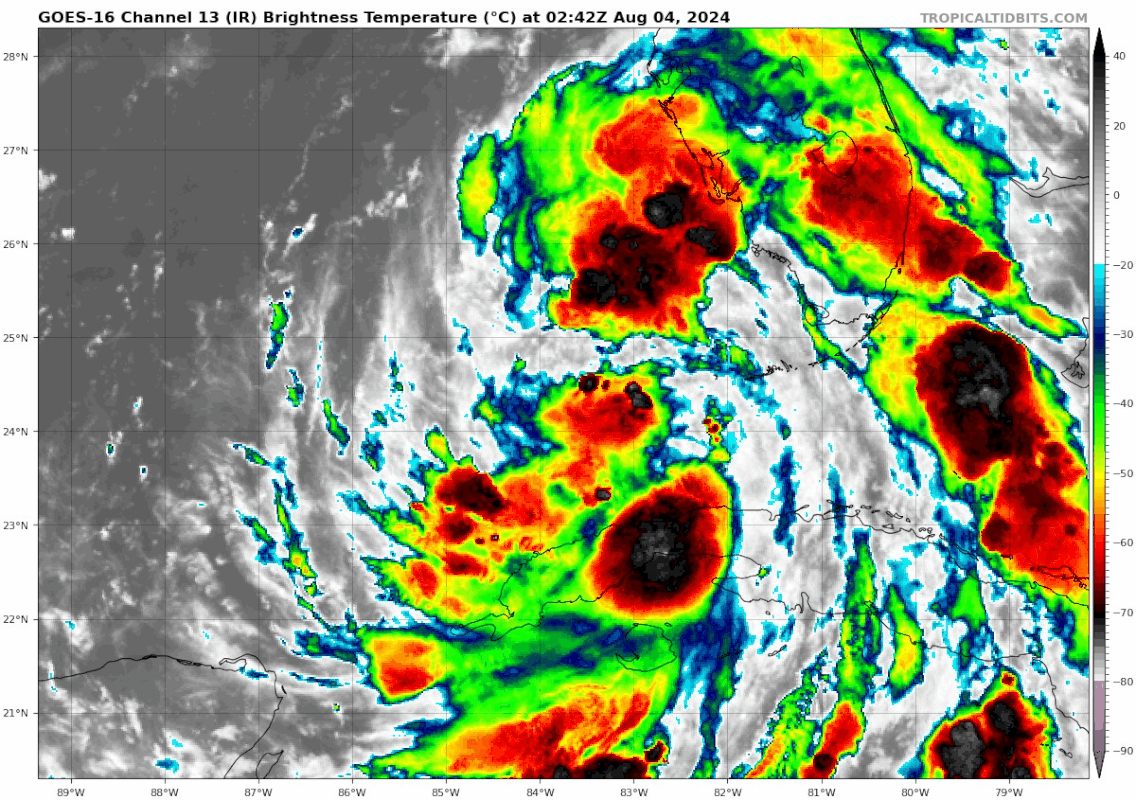
https://i.postimg.cc/dt0LpbtP/goes16-ir-04-L-202408040242.gif
Looking good and intensifying imho
2 likes

Re: ATL: DEBBY - Tropical Storm - Discussion
Good to see so many old timers on today! Welcome all to the best information ahead of time you will ever find. I am wondering what we wake up to tomorrow. The NHC is fantastic on track but decades behind on intensity. The flooding risk looks significant and may saturate areas with higher totals than are expected. A strengthening storm slowing on approach seems like a worse case scenario for what he had 24 hours ago. Gen is fueled, furniture is in the garage, and groceries are bought. Ready for what comes. Good luck to all!
9 likes
The following post is NOT an official forecast and should not be used as such. It is just the opinion of the poster and may or may not be backed by sound meteorological data. It is NOT endorsed by any professional institution including storm2k.org For Official Information please refer to the NHC and NWS products.
-
REDHurricane

- Category 1

- Posts: 438
- Age: 28
- Joined: Sun Jul 03, 2022 2:36 pm
- Location: Northeast Pacific Ocean
Re: ATL: DEBBY - Tropical Storm - Discussion
FireRat wrote:Debby sure has that "look" to it, this is a tricky situation that can escalate quickly. Perhaps it is a 2024 trend we may be about to see, in which tropical systems organize quick and rapidly intensify from the get go, like what Beryl did. Those insane Gulf temps are a wildcard too. We'll be lucky if Debby hits as a Cat 1 or less.
The flood potential will be big too if she lollygags after landfall.
Yeah, it feels like people are severely underestimating the potential threat from Debby and kind of brushing this one off from an intensity perspective... I mean, come on, just look at the environment it has to work with right now through the next 36 hours and remember what happened very recently with another storm taking advantage of unusually favorable conditions and intensifying far more rapidly than any of the guidance suggested. I highlighted "potential" because even if Debby doesn't unexpectedly blow up before landfall, which is certainly possible and even probable according to many of the experts' predictions, people in the storm's path still need to be aware of what could happen if things go very wrong, something we literally just saw a month ago with Beryl.


I know it's easy to play alarmist and backtrack after the fact if the worst case scenario doesn't actually end up occurring, but we are clearly dealing with a whole new ball game over the past few years with regards to how a hurricane season progresses, and we already know what all the experts have said about the level of anomalous activity this season likely has in store. Sure, this might look dumb a few days from now if Debby acts exactly as forecast but I think the NHC needs to stop playing catch-up and broadcasting that all of these systems will definitely only make landfall as a TS/cat 1 when we know there's a real possibility of a more serious threat if conditions turn out to be more favorable than predicted. There needs to be some sort of risk level rating for tropical systems kind of like the SPC has for severe weather, because from everything I'm seeing/hearing, people seem to have it already made up in their minds that they don't need to worry about Debby because the NHC/experts said it's "only going to be a cat 1" or whatever. Ok rant over

12 likes
-
Category5Kaiju

- Category 5
- Posts: 4334
- Joined: Thu Dec 24, 2020 12:45 pm
- Location: Seattle and Phoenix
Re: ATL: DEBBY - Tropical Storm - Discussion
REDHurricane wrote:FireRat wrote:Debby sure has that "look" to it, this is a tricky situation that can escalate quickly. Perhaps it is a 2024 trend we may be about to see, in which tropical systems organize quick and rapidly intensify from the get go, like what Beryl did. Those insane Gulf temps are a wildcard too. We'll be lucky if Debby hits as a Cat 1 or less.
The flood potential will be big too if she lollygags after landfall.
Yeah, it feels like people are severely underestimating the potential threat from Debby and kind of brushing this one off from an intensity perspective... I mean, come on, just look at the environment it has to work with right now through the next 36 hours and remember what happened very recently with another storm taking advantage of unusually favorable conditions and intensifying far more rapidly than any of the guidance suggested. I highlighted "potential" because even if Debby doesn't unexpectedly blow up before landfall, which is certainly possible and even probable according to many of the experts' predictions, people in the storm's path still need to be aware of what could happen if things go very wrong, something we literally just saw a month ago with Beryl.
https://i.ibb.co/R6tWX6J/shear-shear.gif
https://i.ibb.co/GMtDQYn/cdas-sflux-sst-watl-1.png
I know it's easy to play alarmist and backtrack after the fact if the worst case scenario doesn't actually end up occurring, but we are clearly dealing with a whole new ball game over the past few years with regards to how a hurricane season progresses, and we already know what all the experts have said about the level of anomalous activity this season likely has in store. Sure, this might look dumb a few days from now if Debby acts exactly as forecast but I think the NHC needs to stop playing catch-up and broadcasting that all of these systems will definitely only make landfall as a TS/cat 1 when we know there's a real possibility of a more serious threat if conditions turn out to be more favorable than predicted. There needs to be some sort of risk level rating for tropical systems kind of like the SPC has for severe weather, because from everything I'm seeing/hearing, people seem to have it already made up in their minds that they don't need to worry about Debby because the NHC/experts said it's "only going to be a cat 1" or whatever. Ok rant over
"I mean, come on, just look at the environment it has to work with right now through the next 36 hours and remember what happened very recently with another storm taking advantage of unusually favorable conditions and intensifying far more rapidly than any of the guidance suggested."
Which storm? Ngl I find it quite telling that I even have to ask this question.
2 likes
Unless explicitly stated, all info in my posts is based on my own opinions and observations. Tropical storms and hurricanes can be extremely dangerous. Refer to an accredited weather research agency or meteorologist if you need to make serious decisions regarding an approaching storm.
Re: ATL: DEBBY - Tropical Storm - Discussion
REDHurricane wrote:FireRat wrote:Debby sure has that "look" to it, this is a tricky situation that can escalate quickly. Perhaps it is a 2024 trend we may be about to see, in which tropical systems organize quick and rapidly intensify from the get go, like what Beryl did. Those insane Gulf temps are a wildcard too. We'll be lucky if Debby hits as a Cat 1 or less.
The flood potential will be big too if she lollygags after landfall.
Yeah, it feels like people are severely underestimating the potential threat from Debby and kind of brushing this one off from an intensity perspective... I mean, come on, just look at the environment it has to work with right now through the next 36 hours and remember what happened very recently with another storm taking advantage of unusually favorable conditions and intensifying far more rapidly than any of the guidance suggested. I highlighted "potential" because even if Debby doesn't unexpectedly blow up before landfall, which is certainly possible and even probable according to many of the experts' predictions, people in the storm's path still need to be aware of what could happen if things go very wrong, something we literally just saw a month ago with Beryl.
https://i.ibb.co/R6tWX6J/shear-shear.gif
https://i.ibb.co/GMtDQYn/cdas-sflux-sst-watl-1.png
I know it's easy to play alarmist and backtrack after the fact if the worst case scenario doesn't actually end up occurring, but we are clearly dealing with a whole new ball game over the past few years with regards to how a hurricane season progresses, and we already know what all the experts have said about the level of anomalous activity this season likely has in store. Sure, this might look dumb a few days from now if Debby acts exactly as forecast but I think the NHC needs to stop playing catch-up and broadcasting that all of these systems will definitely only make landfall as a TS/cat 1 when we know there's a real possibility of a more serious threat if conditions turn out to be more favorable than predicted. There needs to be some sort of risk level rating for tropical systems kind of like the SPC has for severe weather, because from everything I'm seeing/hearing, people seem to have it already made up in their minds that they don't need to worry about Debby because the NHC/experts said it's "only going to be a cat 1" or whatever. Ok rant over
Yep! Just saw a local update that showed water temps near 84 degrees ahead of it and they included a 79 degree sounding in Tampa Bay after rain. I thought I was looking at October! They are not even showing estimated wind speeds for Duval or Saint Johns. At least they showed the RPM forecast of getting blasted back side on Tuesday. Tomorrow will be a very interesting day indeed!
2 likes
The following post is NOT an official forecast and should not be used as such. It is just the opinion of the poster and may or may not be backed by sound meteorological data. It is NOT endorsed by any professional institution including storm2k.org For Official Information please refer to the NHC and NWS products.
-
stormhunter7

- Category 2

- Posts: 763
- Joined: Mon May 26, 2008 3:13 pm
- Location: Panama City Beach, Florida
- Contact:
Re: ATL: DEBBY - Tropical Storm - Discussion
Pretty sure the mid level and surface center are almost stacked now and the inner core is taking off. Only question is the drier air seen on AF recon on NW side and in north GOM... Will that limit the moisture on the west side???
1 likes
The following post is NOT an official forecast and should not be used as such. It is just the opinion of the poster and may or may not be backed by sound meteorological data. It is NOT endorsed by any professional institution including storm2k.org For Official Information please refer to the NHC and NWS products. http://www.nhc.noaa.gov
Re: ATL: DEBBY - Tropical Storm - Discussion
I definitely can't shake the Otis situation from last year when Acapulco expected a cat 1 and got a cat 5. I enjoy frequent swims on the west coast and the water is decadently blood warm. It is rocket fuel. I would not want to be the in the path of this fearing that potential of unexpected explosive development. I am most definitely watching with intense interest
5 likes
-
Poonwalker
- Category 1
- Posts: 270
- Joined: Tue Sep 20, 2022 11:12 am
Re: ATL: DEBBY - Tropical Storm - Discussion
Last IR loop shows a persistent comma shape and building outflow channel. I think we might see something taking off now. 
8 likes
-
stormhunter7
- Category 2
- Posts: 763
- Joined: Mon May 26, 2008 3:13 pm
- Location: Panama City Beach, Florida
- Contact:
Re: ATL: DEBBY - Tropical Storm - Discussion
4 likes
The following post is NOT an official forecast and should not be used as such. It is just the opinion of the poster and may or may not be backed by sound meteorological data. It is NOT endorsed by any professional institution including storm2k.org For Official Information please refer to the NHC and NWS products. http://www.nhc.noaa.gov

Re: ATL: DEBBY - Tropical Storm - Discussion
Looks like another round of convection is popping around the center, let's see if it will sustain and build a CDO or if it fizzles out after Dmax.
Despite the storm pulling away from the lower Keys and the pressure starting to rise, we are still getting consistent gusts over 40 mph, but still very little in the way of squalls and rain the past 6 hours in the key West vicinity.
To me it looks like the center is moving close to due north now based on radar. Too early to tell if that is just a wobble while the convection is firing or if Debby has started the predicted north trajectory.
1 likes
-
cheezyWXguy

- Category 5
- Posts: 6282
- Joined: Mon Feb 13, 2006 12:29 am
- Location: Dallas, TX
Re: ATL: DEBBY - Tropical Storm - Discussion
Core is still a bit wonky on radar. Occasionally looks like it’s trying to put together a proto-eyewall, then the structure pulls apart. Very similar to Beryl in the 12 hours or so before it got its act together near landfall. This suggests that, like Beryl at the time, the system is still not properly stacked, but as long as deep convection persists this should gradually work itself out. We’ll see how much time it has left over water when it does work itself out, but at this point I think the NHC is on the money with landfall at 75-80kt.
3 likes
-
stormhunter7
- Category 2
- Posts: 763
- Joined: Mon May 26, 2008 3:13 pm
- Location: Panama City Beach, Florida
- Contact:
Re: ATL: DEBBY - Tropical Storm - Discussion
1 likes
The following post is NOT an official forecast and should not be used as such. It is just the opinion of the poster and may or may not be backed by sound meteorological data. It is NOT endorsed by any professional institution including storm2k.org For Official Information please refer to the NHC and NWS products. http://www.nhc.noaa.gov
Re: ATL: DEBBY - Tropical Storm - Discussion
Jr0d wrote:Looks like another round of convection is popping around the center, let's see if it will sustain and build a CDO or if it fizzles out after Dmax.
Despite the storm pulling away from the lower Keys and the pressure starting to rise, we are still getting consistent gusts over 40 mph, but still very little in the way of squalls and rain the past 6 hours in the key West vicinity.
To me it looks like the center is moving close to due north now based on radar. Too early to tell if that is just a wobble while the convection is firing or if Debby has started the predicted north trajectory.
Definitely looks more CDO-like than any of her previous attempts:
6 likes
TC naming lists: retirements and intensity
Most aggressive Advisory #1's in North Atlantic (cr. kevin for starting the list)
Most aggressive Advisory #1's in North Atlantic (cr. kevin for starting the list)
-
REDHurricane
- Category 1
- Posts: 438
- Age: 28
- Joined: Sun Jul 03, 2022 2:36 pm
- Location: Northeast Pacific Ocean
Re: ATL: DEBBY - Tropical Storm - Discussion
cheezyWXguy wrote:Core is still a bit wonky on radar. Occasionally looks like it’s trying to put together a proto-eyewall, then the structure pulls apart. Very similar to Beryl in the 12 hours or so before it got its act together near landfall. This suggests that, like Beryl at the time, the system is still not properly stacked, but as long as deep convection persists this should gradually work itself out. We’ll see how much time it has left over water when it does work itself out, but at this point I think the NHC is on the money with landfall at 75-80kt.
I hope you're right about the landfall intensity, but even going along with your comparison, if Debby currently looks like Beryl 12 hours before landfall then just imagine what Beryl would have done if it had ~24 more hours over water an entire 2ºC warmer...
8 likes
-
cheezyWXguy
- Category 5
- Posts: 6282
- Joined: Mon Feb 13, 2006 12:29 am
- Location: Dallas, TX
Re: ATL: DEBBY - Tropical Storm - Discussion
REDHurricane wrote:cheezyWXguy wrote:Core is still a bit wonky on radar. Occasionally looks like it’s trying to put together a proto-eyewall, then the structure pulls apart. Very similar to Beryl in the 12 hours or so before it got its act together near landfall. This suggests that, like Beryl at the time, the system is still not properly stacked, but as long as deep convection persists this should gradually work itself out. We’ll see how much time it has left over water when it does work itself out, but at this point I think the NHC is on the money with landfall at 75-80kt.
I hope you're right about the landfall intensity, but even going along with your comparison, if Debby currently looks like Beryl 12 hours before landfall then just imagine what Beryl would have done if it had ~24 more hours over water an entire 2ºC warmer...
True, but my point was to compare it to Beryl at a time when it was still working on getting stacked. As you said, it is entirely possible that, like Beryl, it only takes another 12 hours to get a core situated and would probably overperform the intensity forecast. However, it could just as easily take longer if it struggles to mix out the dry air.
1 likes

Re: ATL: DEBBY - Tropical Storm - Discussion
SUMMARY OF 200 AM EDT...0600 UTC...INFORMATION
----------------------------------------------
LOCATION...24.9N 83.9W
ABOUT 65 MI...105 KM WNW OF THE DRY TORTUGAS
ABOUT 230 MI...370 KM SSW OF TAMPA FLORIDA
MAXIMUM SUSTAINED WINDS...45 MPH...75 KM/H
PRESENT MOVEMENT...NW OR 320 DEGREES AT 14 MPH...22 KM/H
MINIMUM CENTRAL PRESSURE...1003 MB...29.62 INCHES
Am I mistaken about recon finding 1000 mb a few hours ago, or was that someone's extrapolation?
0 likes
Andy D
(For official information, please refer to the NHC and NWS products.)
(For official information, please refer to the NHC and NWS products.)
Re: ATL: DEBBY - Tropical Storm - Discussion
Overall satellite and radar presentation looks much better in the last couple of hours. The overall system size seems to have doubled and filled out on the western side. I think we have liftoff.
1 likes
Re: ATL: DEBBY - Tropical Storm - Discussion
Um, I'm not so sure? Woke up and decided to take a peek. I have to be honest but.... our baby girl is, well.... looking rather butt-ugly if you ask me  North-south stretched convection and a COC that's looking like Captain Hook way on its western edge of convection. There's got to be some level of dry air still being advected into its core. At least that's what I'm seeing.
  Okay, back to bed. I'm sure she'll look far better on visible in the morning.
Okay, back to bed. I'm sure she'll look far better on visible in the morning.
2 likes
Andy D
(For official information, please refer to the NHC and NWS products.)
(For official information, please refer to the NHC and NWS products.)
Who is online
Users browsing this forum: No registered users and 37 guests