

ATL: DEBBY - Models
Moderator: S2k Moderators
-
AnnularCane

- S2K Supporter

- Posts: 2964
- Joined: Thu Jun 08, 2006 9:18 am
- Location: Wytheville, VA
Re: ATL: DEBBY - Models
BobHarlem wrote:cat scratched the GEFS
https://i.imgur.com/Ht0ZoBc.png
Looks like some kid scribbled on it.
0 likes
"But it never rained rain. It never snowed snow. And it never blew just wind. It rained things like soup and juice. It snowed mashed potatoes and green peas. And sometimes the wind blew in storms of hamburgers." -- Judi Barrett, Cloudy with a Chance of Meatballs

Re: ATL: DEBBY - Models
GFS caving to icon? upside down world? Luckily intensity later in the week is tamped a little but billions of dollars anyway.
Edit my bad. I had mistakenly hit cmc. GFS said no dice. I’m going west. Who knows but I’d bet GFS is the outlier.
Edit my bad. I had mistakenly hit cmc. GFS said no dice. I’m going west. Who knows but I’d bet GFS is the outlier.
0 likes
Re: ATL: DEBBY - Models
Most GEFS members are well east of the operational GFS. Other global models disagree with the GFS such as the Euro, CMC, ICON, and UKMET.
0 likes


Re: ATL: DEBBY - Models
BobHarlem wrote:cat scratched the GEFS
https://i.imgur.com/Ht0ZoBc.png
As someone who lives on the 30th parallel, I concur that the GFS has some type of cat scratch fever. Just hoping it doesn't see some weird type of TS Fay setup.
1 likes

Re: ATL: DEBBY - Models
06z ICON is very bad, 2 days along the East coast after emerging from Florida and Debby intensifies to 962 mb before its second landfall.

0 likes
-
Kingarabian

- S2K Supporter
- Posts: 16377
- Joined: Sat Aug 08, 2009 3:06 am
- Location: Honolulu, Hawaii

Re: ATL: DEBBY - Models
kevin wrote:06z ICON is very bad, 2 days along the East coast after emerging from Florida and Debby intensifies to 962 mb before its second landfall.
https://i.imgur.com/HFc1euH.png
Given that Debby made landfall further south than most of the models and the forecast track were expecting, another rare ICON verification isn’t impossible. I wonder if we’ll see the 12z runs start to lean towards more time over water like the ICON.
3 likes
Irene '11 Sandy '12 Hermine '16 5/15/2018 Derecho Fay '20 Isaias '20 Elsa '21 Henri '21 Ida '21
I am only a meteorology enthusiast who knows a decent amount about tropical cyclones. Look to the professional mets, the NHC, or your local weather office for the best information.
I am only a meteorology enthusiast who knows a decent amount about tropical cyclones. Look to the professional mets, the NHC, or your local weather office for the best information.
Re: ATL: DEBBY - Models
0 likes
-
tolakram
- Admin

- Posts: 20186
- Age: 62
- Joined: Sun Aug 27, 2006 8:23 pm
- Location: Florence, KY (name is Mark)
Re: ATL: DEBBY - Models
12z ICON

2 likes
M a r k
- - - - -
Join us in chat: Storm2K Chatroom Invite. Android and IOS apps also available.
The posts in this forum are NOT official forecasts and should not be used as such. Posts are NOT endorsed by any professional institution or STORM2K.org. For official information and forecasts, please refer to NHC and NWS products.

Re: ATL: DEBBY - Models
GFS still sticking it to Atlantic and back west path?
0 likes
Just like Jon Snow..."I know nothing" except what I know, and most of what I know is gathered by the fine people of the NHC
-
Kingarabian
- S2K Supporter
- Posts: 16377
- Joined: Sat Aug 08, 2009 3:06 am
- Location: Honolulu, Hawaii
Re: ATL: DEBBY - Models
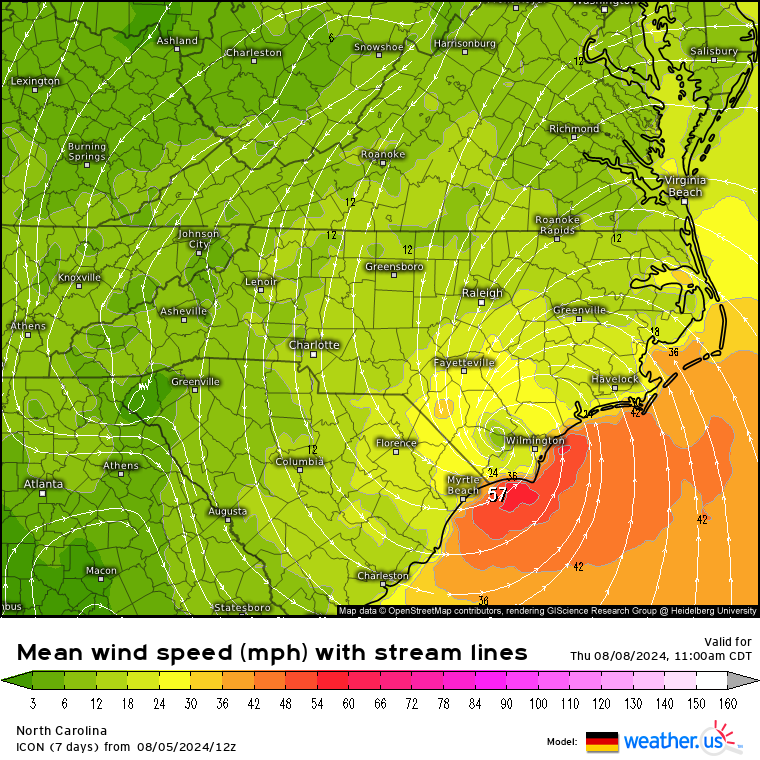
ICON showing pressure in the 960's before a NC/SC landfall. But shows 1 minute winds at barely hurricane strength at landfall. Extensive rainfall though, for Fayetteville and Raleigh.
Last edited by Kingarabian on Mon Aug 05, 2024 12:49 pm, edited 1 time in total.
0 likes
RIP Kobe Bryant
Re: ATL: DEBBY - Models
CronkPSU wrote:GFS still sticking it to Atlantic and back west path?
Kind of yeah. It doesn’t come as far back before lifting out though.
1 likes
-
tolakram
- Admin
- Posts: 20186
- Age: 62
- Joined: Sun Aug 27, 2006 8:23 pm
- Location: Florence, KY (name is Mark)
Re: ATL: DEBBY - Models
I don't trust any model that loses the low center. ICON or Euro seem most likely to me. The GFS spins down the low to above 1000mb and then jumps the center off the coast. Maybe it happens, I just doubt it.
1 likes
M a r k
- - - - -
Join us in chat: Storm2K Chatroom Invite. Android and IOS apps also available.
The posts in this forum are NOT official forecasts and should not be used as such. Posts are NOT endorsed by any professional institution or STORM2K.org. For official information and forecasts, please refer to NHC and NWS products.
- - - - -
Join us in chat: Storm2K Chatroom Invite. Android and IOS apps also available.
The posts in this forum are NOT official forecasts and should not be used as such. Posts are NOT endorsed by any professional institution or STORM2K.org. For official information and forecasts, please refer to NHC and NWS products.
-
BIFF_THE_UNRULY
- Tropical Storm

- Posts: 143
- Joined: Fri Jun 28, 2024 2:12 pm
Re: ATL: DEBBY - Models
BobHarlem wrote:cat scratched the GEFS
https://i.imgur.com/Ht0ZoBc.png
When you dont like the Spaghetti
1 likes
Re: ATL: DEBBY - Models
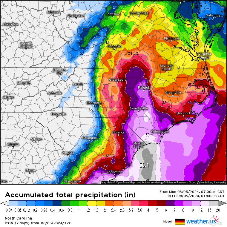
12z EC Fast mimics the ICON but looks a little weaker (983ish vs. 962). ICON is a hair faster toward the NC/SC border. I haven't seen the operational yet, so I don't know exactly where EC is going to landfall again. EC Fast has it pretty closet to the SC/NC border at 72 hours though it's trailing where ICON says it would be. CMC is a bit behind them and much weaker as it spends more time over land, goes back in and loops around South Carolina. It also lifts out at the front of the trough rather than getting absorbed.
HWRF goes off the GA coast, spins there for a few days, comes back in and ends just north of Mobile as a remnant low. HMON is fairly weak going forward but gets to the ocean and hits SC around 992mb. HAFS-A keeps it weak offshore with broadened windfield and a central pressure around 996 when it comes back to SC.
Basically every one of these models has a different solution. Even the mesoscales - FV3 High Res takes a day and a half to get to the GA Coast and spins there offshore deepening a little similar to HWRF. NAM 12km is a little south of the EC and ICON in where it it hits South Carolina.
1 likes

Re: ATL: DEBBY - Models
Really hard to determine where a storm goes with great accuracy, when it comes to a halt.
Regardless...gonna get wet here in NC
Regardless...gonna get wet here in NC
0 likes
I'm not a meteorologist, I'm an electronics engineer. While I can probably fix your toaster oven, you're not going to learn about storms from me!
New Mexico had no hurricanes. Then I moved to NC right before Fran.....
New Mexico had no hurricanes. Then I moved to NC right before Fran.....

Re: ATL: DEBBY - Models
One key distinction that I see is that the GFS wont have Debby over water until about 36 hr.'s from this past 12 run (no different than prior run forecast). Meanwhile the ICON 12Z has Debby over water far sooner in about 21 hr's.
The faster motion ICON model also plays into it taking the storm back down to 961mb while the GFS (taking longer to emerge offshore) only strengthens the storm to about 992mb. I surmise that the weaker - more shallow Debby might be slower to react to the broader mid level flow thus getting trapped and pushed back westward. It would make sense that a deeper core would ultimately get yanked up and into the Westerlies quicker.
Bottom line, a short-term GFS solution would be more impactful to continued heavy precip over NE Florida and Southeast GA, and possibly a heavier toll to coastal surge and beach erosion, dock damage, etc either side of Jacksonville. On the other hand, an ICON outcome would mean a quicker reprieve for NE Florida but a very obvious potential impact further up the coast from Savannah northward toward Wilmington. Looks to me like NHC is leaning more toward an ICON outcome in terms of track and timing. Here's where wobble-watching and "now-casting" comes into play (especially if I were in the coastal GA/S. Carolina/N. Carolina area). My only two cents worth are that if the ICON is better sniffing out the 2-3 day short term track, I'm a little doubtful on the extent of deepening it's presently forecasting out of account that I don't see this storm's inner core and pressure gradient tightening up quite as much. That and, it's my sense that ICON run-to-run intensity forecasts do tend to be all over the map.
1 likes
Andy D
(For official information, please refer to the NHC and NWS products.)
(For official information, please refer to the NHC and NWS products.)
Re: ATL: DEBBY - Models
Icon has certainly had its share of good calls over the recent years, and this may be another. Icon looks quite bad for us in NC. Debby has been quite the storm to track. Not a lot of consensus as Debby get drifty without steering. Looking forward to seeing updates this evening. Man this is nerve racking.
2 likes

Re: ATL: DEBBY - Models
Powellrm wrote:Icon has certainly had its share of good calls over the recent years, and this may be another. Icon looks quite bad for us in NC. Debby has been quite the storm to track. Not a lot of consensus as Debby get drifty without steering. Looking forward to seeing updates this evening. Man this is nerve racking.
These slow storms from the south always are nerve wracking for us in the Carolinas. We are used to them hitting Florida and then being here in 24 hours with the track nailed down pretty well. Some pretty good models have been showing much different tracks/speeds than the official forecast, some stubbornly (ICON). NHC guys must be chewing their fingernails every time they put out a track update......
2 likes
Ginger-(eye),Dennis,Diana,Kate,Gloria,Charley-(eye),Allison,Arthur,Bertha,Fran,Josephine,Bonnie,Earl,Dennis-(twice),Floyd, Isabel-(eye),Charley,Ophelia-(eyewall),Ernesto,Barry,Hanna,Irene-(eye),Arthur-(eye), Florence, Dorian, and countless depressions, storms, and nor'easters.
Who is online
Users browsing this forum: No registered users and 74 guests