2024 Global Model Runs Discussion (Out thru day 16)
Moderator: S2k Moderators
Forum rules

The posts in this forum are NOT official forecasts and should not be used as such. They are just the opinion of the poster and may or may not be backed by sound meteorological data. They are NOT endorsed by any professional institution or STORM2K. For official information, please refer to products from the National Hurricane Center and National Weather Service.
-
MarioProtVI
- Category 5

- Posts: 1034
- Age: 24
- Joined: Sun Sep 29, 2019 7:33 pm
- Location: New Jersey
Re: 2024 Global Model Runs Discussion (Out thru day 16)
Broken run. Goes from 1003 to 980s in 6 hrs. Explains why the ensemble support is pretty weak when compared to operational. But I think something like the euro is more likely for this one where it doesn’t develop until N of Hispaniola and then from there is up to the timing of trough and how far west it gets.
0 likes
-
AutoPenalti
- Category 5
- Posts: 4091
- Age: 29
- Joined: Mon Aug 17, 2015 4:16 pm
- Location: Ft. Lauderdale, Florida
Re: 2024 Global Model Runs Discussion (Out thru day 16)
Key thing to note for future runs is the weakness of the ridge and timing of trough, seems consistent for now, just have to know where that opening occurs.
1 likes
The posts in this forum are NOT official forecasts and should not be used as such. They are just the opinion of the poster and may or may not be backed by sound meteorological data. They are NOT endorsed by any professional institution or STORM2K. For official information, please refer to products from the NHC and NWS.
Model Runs Cheat Sheet:
GFS (5:30 AM/PM, 11:30 AM/PM)
HWRF, GFDL, UKMET, NAVGEM (6:30-8:00 AM/PM, 12:30-2:00 AM/PM)
ECMWF (1:45 AM/PM)
TCVN is a weighted averaged
-
WaveBreaking

- Category 2

- Posts: 717
- Joined: Sun Jun 30, 2024 11:33 am
- Location: US
Re: 2024 Global Model Runs Discussion (Out thru day 16)
This is pretty far out in the runs, but a little worrying how most op models have the African monsoon rapid-fire waves after the disturbance that models are latching on to.


5 likes
I am NOT a professional meteorologist, so take all of my posts with a grain of salt. My opinions are mine and mine alone.

Re: 2024 Global Model Runs Discussion (Out thru day 16)
(No, this is just one individual member from EPS)
https://x.com/zeb199818/status/1821349756712710376
1 likes
TC naming lists: retirements and intensity
Most aggressive Advisory #1's in North Atlantic (cr. kevin for starting the list)
Most aggressive Advisory #1's in North Atlantic (cr. kevin for starting the list)
Re: 2024 Global Model Runs Discussion (Out thru day 16)
0z GFS: Recurves east of 18z (after hitting PR, Dominican Republic and Turks & Caicos) and stronger, as it intensifies to 970s while riding the Gulf Stream. This may be due to the development of a short-lived (sub)tropical storm near New England.
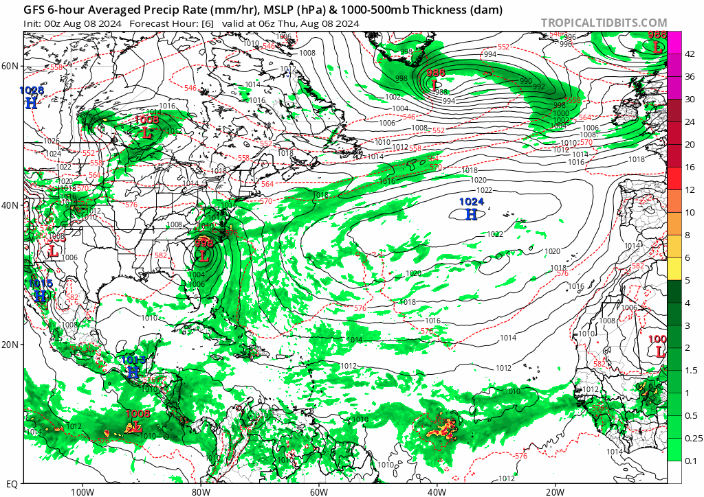
0z ICON is west of 12z, but on a similar track as GFS. 0z CMC drops development.
0z ICON is west of 12z, but on a similar track as GFS. 0z CMC drops development.
0 likes
TC naming lists: retirements and intensity
Most aggressive Advisory #1's in North Atlantic (cr. kevin for starting the list)
Most aggressive Advisory #1's in North Atlantic (cr. kevin for starting the list)
-
Stratton23
- Category 5
- Posts: 3518
- Joined: Fri Jul 21, 2023 10:59 pm
- Location: Katy, Tx
Re: 2024 Global Model Runs Discussion (Out thru day 16)
GEPS has backed off on development of this wave fwiw
0 likes
-
Stratton23
- Category 5
- Posts: 3518
- Joined: Fri Jul 21, 2023 10:59 pm
- Location: Katy, Tx
Re: 2024 Global Model Runs Discussion (Out thru day 16)
Euro trending towards a weaker trough over the eastern US, more west again
0 likes
-
weeniepatrol

- Category 5
- Posts: 1340
- Joined: Sat Aug 22, 2020 5:30 pm
- Location: WA State

-
cycloneye

- Admin

- Posts: 149266
- Age: 69
- Joined: Thu Oct 10, 2002 10:54 am
- Location: San Juan, Puerto Rico
Re: 2024 Global Model Runs Discussion (Out thru day 16)
Ok gang. All model runs will now be posted at the thread for the area of possible development.
https://www.storm2k.org/phpbb2/viewtopi ... 5#p3079685
https://www.storm2k.org/phpbb2/viewtopi ... 5#p3079685
1 likes
Visit the Caribbean-Central America Weather Thread where you can find at first post web cams,radars
and observations from Caribbean basin members Click Here
and observations from Caribbean basin members Click Here

Re: 2024 Global Model Runs Discussion (Out thru day 16)
6z GFS develops another wave behind the lemon and takes in on an Irma-like track through the northern Lesser Antilles/just north of the Greater Antilles. The precursor wave for that emerges off of Africa on Tuesday or Wednesday.
0 likes
Irene '11 Sandy '12 Hermine '16 5/15/2018 Derecho Fay '20 Isaias '20 Elsa '21 Henri '21 Ida '21
I am only a meteorology enthusiast who knows a decent amount about tropical cyclones. Look to the professional mets, the NHC, or your local weather office for the best information.
I am only a meteorology enthusiast who knows a decent amount about tropical cyclones. Look to the professional mets, the NHC, or your local weather office for the best information.
-
SFLcane

- S2K Supporter

- Posts: 10281
- Age: 48
- Joined: Sat Jun 05, 2010 1:44 pm
- Location: Lake Worth Florida
Re: 2024 Global Model Runs Discussion (Out thru day 16)
aspen wrote:6z GFS develops another wave behind the lemon and takes in on an Irma-like track through the northern Lesser Antilles/just north of the Greater Antilles. The precursor wave for that emerges off of Africa on Tuesday or Wednesday.
No irma there.. Seems we have gone back to a trof pattern one after another reinforcing. Subject to change off course at this range.
0 likes
-
TomballEd
- Category 5
- Posts: 1263
- Age: 62
- Joined: Wed Aug 16, 2023 4:52 pm
- Location: Spring/Klein area, not Tomball
Re: 2024 Global Model Runs Discussion (Out thru day 16)
Teban54 wrote::lol:
(No, this is just one individual member from EPS)
https://x.com/zeb199818/status/1821349756712710376
I count no more than 10 EPS members at 10 days that would enter/possibly enter the Gulf. The X poster going beyond 240 hours to post the one perturbation that has a big hurricane in the Gulf is a smidge weenie. The 0Z EPS has one significant TC in the Gulf.
1 likes
-
cheezyWXguy

- Category 5
- Posts: 6281
- Joined: Mon Feb 13, 2006 12:29 am
- Location: Dallas, TX
Re: 2024 Global Model Runs Discussion (Out thru day 16)
Not saying it’s incorrect this time, it could very well be right, but there’s talk every year about how the gfs has a bias toward overdoing persistent troughing on the east coast. Just something to watch for. It’ll be nice if this is a clear cut recurve from the beginning, as I don’t think we’ll be that lucky with every storm this year, but this trough is so far out for now that I’m not really putting stock into any model run past the Lesser Antilles yet
2 likes
-
cheezyWXguy
- Category 5
- Posts: 6281
- Joined: Mon Feb 13, 2006 12:29 am
- Location: Dallas, TX
Re: 2024 Global Model Runs Discussion (Out thru day 16)
TomballEd wrote:Teban54 wrote::lol:
(No, this is just one individual member from EPS)
https://x.com/zeb199818/status/1821349756712710376
I count no more than 10 EPS members at 10 days that would enter/possibly enter the Gulf. The X poster going beyond 240 hours to post the one perturbation that has a big hurricane in the Gulf is a smidge weenie. The 0Z EPS has one significant TC in the Gulf.
Ha, more than just a smidge imo. Seems like a full on Costco hotdog to me
0 likes
-
WeatherBoy2000
- Category 1

- Posts: 460
- Joined: Mon Apr 10, 2023 9:29 am
Re: 2024 Global Model Runs Discussion (Out thru day 16)
SFLcane wrote:aspen wrote:6z GFS develops another wave behind the lemon and takes in on an Irma-like track through the northern Lesser Antilles/just north of the Greater Antilles. The precursor wave for that emerges off of Africa on Tuesday or Wednesday.
No irma there.. Seems we have gone back to a trof pattern one after another reinforcing. Subject to change off course at this range.
https://i.postimg.cc/PqRyfnk5/jjjj.png
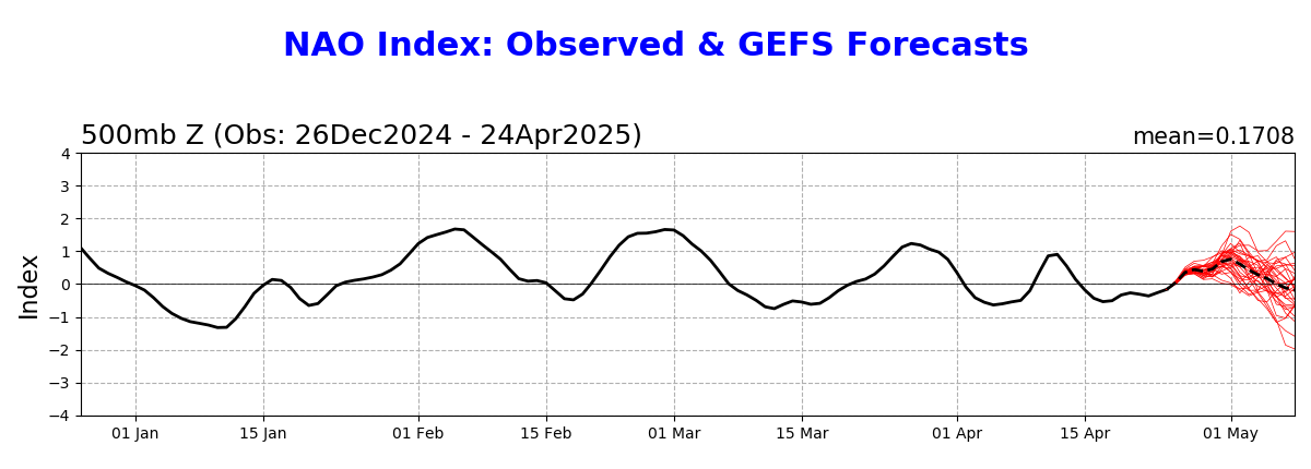
I think it's way too early to say so far out and based off just one gfs run. One thing to keep in mind is that the NAO is currently neutral with an unpredictable future:
1 likes
-
SFLcane
- S2K Supporter
- Posts: 10281
- Age: 48
- Joined: Sat Jun 05, 2010 1:44 pm
- Location: Lake Worth Florida
Re: 2024 Global Model Runs Discussion (Out thru day 16)
eps shows similar.. Might turn way before the bahamas hopefully away from Luis.
0 likes
Re: 2024 Global Model Runs Discussion (Out thru day 16)
Long range ensembles seem to hint at maybe 3-4 areas all at once (including the currently "outlooked" area) in the Atlantic to be watching sometime late next week.
0 likes
Re: 2024 Global Model Runs Discussion (Out thru day 16)
Various runs of the GFS, Euro, CMC, and ICON suggest there could be another TC forming behind the current AOI, from a wave that emerges off of Africa in 2-3 days. So far there’s not much consistency between models and individual runs of the same model. Most just show a wave.
I suspect this wave could be limited by outflow from the AOI if it develops into a hurricane, and if the two aren’t separated enough. There have been a lot of cases of MDR systems with a modeled “sibling” right behind it that either doesn’t form (Elsa ‘21, Beryl ‘24) or falls far below model expectations (Bret and Cindy ‘23). However, there have also been occasional cases of strong MDR systems co-existing, such as Irma and Jose. So who knows. There are a few more waves after that one which may need to be watched too.
I suspect this wave could be limited by outflow from the AOI if it develops into a hurricane, and if the two aren’t separated enough. There have been a lot of cases of MDR systems with a modeled “sibling” right behind it that either doesn’t form (Elsa ‘21, Beryl ‘24) or falls far below model expectations (Bret and Cindy ‘23). However, there have also been occasional cases of strong MDR systems co-existing, such as Irma and Jose. So who knows. There are a few more waves after that one which may need to be watched too.
1 likes
Irene '11 Sandy '12 Hermine '16 5/15/2018 Derecho Fay '20 Isaias '20 Elsa '21 Henri '21 Ida '21
I am only a meteorology enthusiast who knows a decent amount about tropical cyclones. Look to the professional mets, the NHC, or your local weather office for the best information.
I am only a meteorology enthusiast who knows a decent amount about tropical cyclones. Look to the professional mets, the NHC, or your local weather office for the best information.
Re: 2024 Global Model Runs Discussion (Out thru day 16)
aspen wrote:There have been a lot of cases of MDR systems with a modeled “sibling” right behind it that either doesn’t form (Elsa ‘21, Beryl ‘24) or falls far below model expectations (Bret and Cindy ‘23).
I think Cindy 2023 actually outperformed the models. Most runs initially didn't even have it form at all until just a few days before it actually did, while they had a much longer lead time for Bret.
Now, if you're talking about how Cindy's formation limited Bret from reaching its ceiling, that may be more plausible. But Bret also had to deal with June climo (as with all other systems you mentioned) in an El Nino year, which is very different from what we have now.
0 likes
TC naming lists: retirements and intensity
Most aggressive Advisory #1's in North Atlantic (cr. kevin for starting the list)
Most aggressive Advisory #1's in North Atlantic (cr. kevin for starting the list)

Re: 2024 Global Model Runs Discussion (Out thru day 16)
Teban54 wrote:aspen wrote:There have been a lot of cases of MDR systems with a modeled “sibling” right behind it that either doesn’t form (Elsa ‘21, Beryl ‘24) or falls far below model expectations (Bret and Cindy ‘23).
I think Cindy 2023 actually outperformed the models. Most runs initially didn't even have it form at all until just a few days before it actually did, while they had a much longer lead time for Bret.
Now, if you're talking about how Cindy's formation limited Bret from reaching its ceiling, that may be more plausible. But Bret also had to deal with June climo (as with all other systems you mentioned) in an El Nino year, which is very different from what we have now.
Also worth noting, none of these were in mid to late August, where it's more common to have back to back development.
1 likes
The above post is not official and should not be used as such. It is the opinion of the poster and may or may not be backed by sound meteorological data. It is not endorsed by any professional institution or storm2k.org. For official information, please refer to the NHC and NWS products.
Who is online
Users browsing this forum: dexterlabio, Hurricane2022, USTropics and 127 guests