Tropical Wave in Eastern Atlantic (Is Invest 98L)
Moderator: S2k Moderators
Forum rules

The posts in this forum are NOT official forecasts and should not be used as such. They are just the opinion of the poster and may or may not be backed by sound meteorological data. They are NOT endorsed by any professional institution or STORM2K. For official information, please refer to products from the National Hurricane Center and National Weather Service.
-
TomballEd
- Category 5

- Posts: 1318
- Age: 62
- Joined: Wed Aug 16, 2023 4:52 pm
- Location: Spring/Klein area, not Tomball
Re: 2024 Global Model Runs Discussion (Out thru day 16)
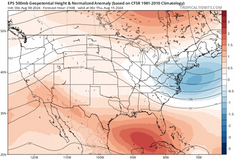
EPS has a strong signal for recurve and missing ECUSA. Obviously, things can change this far out, but I still think development before the Caribbean makes it much more likely to recurve
0 likes
-
jlauderdal
- S2K Supporter

- Posts: 7240
- Joined: Wed May 19, 2004 5:46 am
- Location: NE Fort Lauderdale
- Contact:
Re: Disturbance near the Lesser and Greater Antilles (0/30)
24 hours ago it looked very different, reminds of debbie on the early runs
0 likes
-
AutoPenalti
- Category 5
- Posts: 4091
- Age: 29
- Joined: Mon Aug 17, 2015 4:16 pm
- Location: Ft. Lauderdale, Florida
Re: Disturbance near the Lesser and Greater Antilles (0/30)
jlauderdal wrote:
24 hours ago it looked very different, reminds of debbie on the early runs
Weaker(late bloomer) solutions compared to the 0z. Not a good sign.
0 likes
The posts in this forum are NOT official forecasts and should not be used as such. They are just the opinion of the poster and may or may not be backed by sound meteorological data. They are NOT endorsed by any professional institution or STORM2K. For official information, please refer to products from the NHC and NWS.
Model Runs Cheat Sheet:
GFS (5:30 AM/PM, 11:30 AM/PM)
HWRF, GFDL, UKMET, NAVGEM (6:30-8:00 AM/PM, 12:30-2:00 AM/PM)
ECMWF (1:45 AM/PM)
TCVN is a weighted averaged
-
WeatherBoy2000
- Category 1

- Posts: 463
- Joined: Mon Apr 10, 2023 9:29 am
Re: Disturbance near the Lesser and Greater Antilles (0/30)
That hardly looks like an out to sea run to me. There's also this:
https://x.com/BigJoeBastardi/status/1821479936848257397
0 likes

Re: Disturbance near the Lesser and Greater Antilles (0/30)
Looks like they all go through the Hebert Box.
2 likes
Igor 2010, Sandy 2012, Fay 2014, Gonzalo 2014, Joaquin 2015, Nicole 2016, Humberto 2019, Imelda 2025
I am only a tropical weather enthusiast. My predictions are not official and may or may not be backed by sound meteorological data. For official information, please refer to the NHC and NWS products.
I am only a tropical weather enthusiast. My predictions are not official and may or may not be backed by sound meteorological data. For official information, please refer to the NHC and NWS products.

Re: Disturbance near the Lesser and Greater Antilles (0/30)
And another developing wave right behind it, which might be the one on the 06z GFS.
0 likes
Irene '11 Sandy '12 Hermine '16 5/15/2018 Derecho Fay '20 Isaias '20 Elsa '21 Henri '21 Ida '21
I am only a meteorology enthusiast who knows a decent amount about tropical cyclones. Look to the professional mets, the NHC, or your local weather office for the best information.
I am only a meteorology enthusiast who knows a decent amount about tropical cyclones. Look to the professional mets, the NHC, or your local weather office for the best information.

-
wxman57

- Moderator-Pro Met

- Posts: 23175
- Age: 68
- Joined: Sat Jun 21, 2003 8:06 pm
- Location: Houston, TX (southwest)
Re: Disturbance near the Lesser and Greater Antilles (0/30)
The disturbance that the models develop is not near the Lesser Antilles, it's way out near 30W. You can track the 850mb vorticity back to the eastern Tropical Atlantic. Good chance of development next Tue/Wed. If it develops then, it should see a big weakness in the ridge to the north and take a track north of the Caribbean. Hope so. Don't need another in the Gulf or on the East Coast. Nothing guaranteed this far out.
6 likes
-
AutoPenalti
- Category 5
- Posts: 4091
- Age: 29
- Joined: Mon Aug 17, 2015 4:16 pm
- Location: Ft. Lauderdale, Florida
Re: Disturbance near the Lesser and Greater Antilles (0/30)
wxman57 wrote:The disturbance that the models develop is not near the Lesser Antilles, it's way out near 30W. You can track the 850mb vorticity back to the eastern Tropical Atlantic. Good chance of development next Tue/Wed. If it develops then, it should see a big weakness in the ridge to the north and take a track north of the Caribbean. Hope so. Don't need another in the Gulf or on the East Coast. Nothing guaranteed this far out.
Yup, it's nearing 30W. GFS has hinted at this wave developing from here. https://x.com/TacleTheTropics/status/1821528481420779897
0 likes
The posts in this forum are NOT official forecasts and should not be used as such. They are just the opinion of the poster and may or may not be backed by sound meteorological data. They are NOT endorsed by any professional institution or STORM2K. For official information, please refer to products from the NHC and NWS.
Model Runs Cheat Sheet:
GFS (5:30 AM/PM, 11:30 AM/PM)
HWRF, GFDL, UKMET, NAVGEM (6:30-8:00 AM/PM, 12:30-2:00 AM/PM)
ECMWF (1:45 AM/PM)
TCVN is a weighted averaged
Re: Disturbance near the Lesser and Greater Antilles
Category5Kaiju wrote:Teban54 wrote:mantis83 wrote:East coast troughing showing up just as it starts to get active. Perfect timing if you ask me……
Hey Mantis, what happened to your earlier calls that the Euro for Debby was on a "consistent trend" of recurving east of Florida, due to the "Florida forcefield" that was in "full effect"?
It's all good. I mean, 2010, 2011, 2021, and 2023 were like that. Well, that is until you meet a season like 1933, 2004, or 2017 where the "frequent-OTS-storms" pattern fails to materialize.
To be fair, those 2004/2017 seasons tend to be the outlier compared to all those other recent seasons you mention. Of course, it was no bearing on the current pattern and season
Too early to tell but we've seen this OTS pattern shift further west, already with Debby.
0 likes
Andrew (1992), Irene (1999), Frances (2004), Katrina (2005), Wilma (2005), Fay (2008), Irma (2017), Eta (2020), Ian (2022)
-
cycloneye

- Admin

- Posts: 149700
- Age: 69
- Joined: Thu Oct 10, 2002 10:54 am
- Location: San Juan, Puerto Rico
Re: Disturbance near the Lesser and Greater Antilles (0/30)
12z ICON has the strongest run yet for this system.

0 likes
Visit the Caribbean-Central America Weather Thread where you can find at first post web cams,radars
and observations from Caribbean basin members Click Here
and observations from Caribbean basin members Click Here
Re: Disturbance near the Lesser and Greater Antilles
Nuno wrote:Category5Kaiju wrote:Teban54 wrote:Hey Mantis, what happened to your earlier calls that the Euro for Debby was on a "consistent trend" of recurving east of Florida, due to the "Florida forcefield" that was in "full effect"?
It's all good. I mean, 2010, 2011, 2021, and 2023 were like that. Well, that is until you meet a season like 1933, 2004, or 2017 where the "frequent-OTS-storms" pattern fails to materialize.
To be fair, those 2004/2017 seasons tend to be the outlier compared to all those other recent seasons you mention. Of course, it was no bearing on the current pattern and season
Too early to tell but we've seen this OTS pattern shift further west, already with Debby.
I wonder just how much further west/SW the models will shift in the coming week, if at all. Will it be a slight shift towards an Irene/Floyd track that puts the entire eastern seaboard at risk? Will it be a significant shift towards a Laura or Beryl-like track that threatens the Gulf? Or will it stay north of the GAs and go into Bermuda or Atlantic Canada like Fiona? Tons of possibilities at this point.
3 likes
Irene '11 Sandy '12 Hermine '16 5/15/2018 Derecho Fay '20 Isaias '20 Elsa '21 Henri '21 Ida '21
I am only a meteorology enthusiast who knows a decent amount about tropical cyclones. Look to the professional mets, the NHC, or your local weather office for the best information.
I am only a meteorology enthusiast who knows a decent amount about tropical cyclones. Look to the professional mets, the NHC, or your local weather office for the best information.
-
AutoPenalti
- Category 5
- Posts: 4091
- Age: 29
- Joined: Mon Aug 17, 2015 4:16 pm
- Location: Ft. Lauderdale, Florida
Re: Disturbance near the Lesser and Greater Antilles (0/30)
Weakness is there at least.
0 likes
The posts in this forum are NOT official forecasts and should not be used as such. They are just the opinion of the poster and may or may not be backed by sound meteorological data. They are NOT endorsed by any professional institution or STORM2K. For official information, please refer to products from the NHC and NWS.
Model Runs Cheat Sheet:
GFS (5:30 AM/PM, 11:30 AM/PM)
HWRF, GFDL, UKMET, NAVGEM (6:30-8:00 AM/PM, 12:30-2:00 AM/PM)
ECMWF (1:45 AM/PM)
TCVN is a weighted averaged
-
cycloneye
- Admin
- Posts: 149700
- Age: 69
- Joined: Thu Oct 10, 2002 10:54 am
- Location: San Juan, Puerto Rico
Re: Disturbance in Eastern Atlantic (0/30)
kevin, modified the title to reflect the area that may trigger development.
0 likes
Visit the Caribbean-Central America Weather Thread where you can find at first post web cams,radars
and observations from Caribbean basin members Click Here
and observations from Caribbean basin members Click Here
-
TomballEd
- Category 5
- Posts: 1318
- Age: 62
- Joined: Wed Aug 16, 2023 4:52 pm
- Location: Spring/Klein area, not Tomball
Re: Disturbance near the Lesser and Greater Antilles (0/30)
wxman57 wrote:The disturbance that the models develop is not near the Lesser Antilles, it's way out near 30W. You can track the 850mb vorticity back to the eastern Tropical Atlantic. Good chance of development next Tue/Wed. If it develops then, it should see a big weakness in the ridge to the north and take a track north of the Caribbean. Hope so. Don't need another in the Gulf or on the East Coast. Nothing guaranteed this far out.
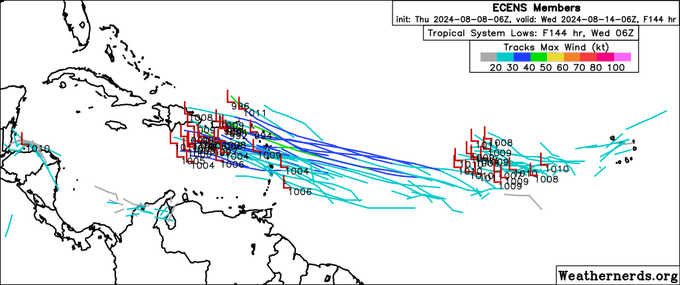
Looking at 0Z ensembles, GFS family and CMC family make a recurve almost certain, the GFS could give it a window. If it enters the Caribbean and isn't already a TC, and gets past 80W before developing, that is the only way to the Gulf based on current 15 day ensemble heights.
WxMan57, do you have access to the control run of the ensemble. I'm starting to think the op GFS isn't well supported in TC genesis by the ensembles because of the lower resolution. If the control run isn't close to the op, than resolution does make a difference.
Now for the ICON, it develops before the Caribbean and is curving N, apparently safely after sea (after it passes through the Mona Gap, which would spare Hispaniola, but is probably not going to happen). I know, the ICON, but it is available before the GFS.
0 likes
-
'CaneFreak

- Category 5
- Posts: 1487
- Joined: Mon Jun 05, 2006 10:50 am
- Location: New Bern, NC
Re: Disturbance in Eastern Atlantic (0/30)
Latest operational GFS out to 168 hours is weaker and farther southwest much closer to the north coast of the Dominican Republic.
0 likes
Re: Disturbance in Eastern Atlantic (0/30)
12z CMC finally gets a robust TC out of this.
12z GFS is weaker heading into the Lesser Antilles and interacts with Hispaniola.
12z GFS is weaker heading into the Lesser Antilles and interacts with Hispaniola.
0 likes
Irene '11 Sandy '12 Hermine '16 5/15/2018 Derecho Fay '20 Isaias '20 Elsa '21 Henri '21 Ida '21
I am only a meteorology enthusiast who knows a decent amount about tropical cyclones. Look to the professional mets, the NHC, or your local weather office for the best information.
I am only a meteorology enthusiast who knows a decent amount about tropical cyclones. Look to the professional mets, the NHC, or your local weather office for the best information.
-
toad strangler

- S2K Supporter
- Posts: 4546
- Joined: Sun Jul 28, 2013 3:09 pm
- Location: Earth
- Contact:
Re: Disturbance in Eastern Atlantic (0/30)
12z GFS weaker but further W getting into the S Bahamas through 189
0 likes
My Weather Station
https://www.wunderground.com/dashboard/pws/KFLPORTS603
https://www.wunderground.com/dashboard/pws/KFLPORTS603
-
Spacecoast

- Category 2

- Posts: 773
- Joined: Thu Aug 31, 2017 2:03 pm

-
toad strangler
- S2K Supporter
- Posts: 4546
- Joined: Sun Jul 28, 2013 3:09 pm
- Location: Earth
- Contact:
Re: Disturbance in Eastern Atlantic (0/30)
Where is mantis when you need him. It's up, up, and away! after making it as far W as S Bahamas on the 12z GFS operational.
0 likes
My Weather Station
https://www.wunderground.com/dashboard/pws/KFLPORTS603
https://www.wunderground.com/dashboard/pws/KFLPORTS603
Who is online
Users browsing this forum: Google Adsense [Bot], ouragans, pepecool20, Ulf and 210 guests